07/28-29/07
Kim is perhaps "the" Suiattle River fanatic. Road
washouts have not stopped her from visiting. After 2003 the last 2 miles
of road were closed to auto traffic. After 2006 the last 11 miles are now
closed. What to do? She wanted to bike the road with overnight gear then
hike 4600' up Sulphur Mountain. Sounded like fun! We made it through Darrington
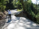
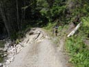
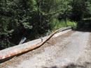
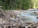
and on to the washout at milepost 12 on the Suiattle River Road. I was surprised
to see half a dozen other cars there on Saturday morning at 10:30. The first
washout is immediate and has a dirt trail winding through brush. The river
is far below the grade. The other washouts allowed passing on the far left
side without going into the forest.
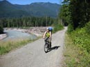
The next eight miles of road is fine. There are some short segments with sand on the road. The road gains about 700' net feet over the eleven miles. There are about 200' of downhill heading in making it about 900' in and 200' out. Carrying the overnight pack proved to not be a big problem. Kim and I chose to use low top trailrunner shoes for biking and hiking in lieu of carrying boots as well.
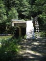
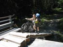
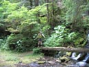
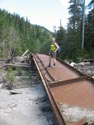
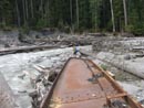
At the nine mile mark we reached Downey Creek. The left side of the road has now washed away leaving less dirt at the approach to the bridge. The old log built ladder is still there as well as a wooden ramp climbing the dozen feet or so up to the bridge deck. That was new since Kim's last visit. We poked around and found the start of the old Green Mountain trail. There are cut logs and then "newer" downed logs that look like they have been there for 30 years. It would be interesting to try and follow the old trail to the new start some 2 miles and 1800' above.
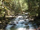
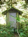
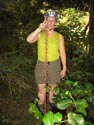
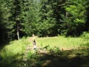
We also found an old outhouse and a strange flower that is five feet tall. After exploring we were able to walk our bikes right up the ramp and onto the bridge. Two more miles of biking brought us to the end of the road and the Suiattle River Trailhead. The old road below the trailhead sign drops quickly to the river. At that point it is asphalt. A mystery as to why the last dozen miles of road is gravel and the road to the river is paved. We set up camp on sand with a nice view of the roaring river.
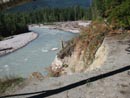
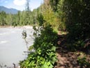
With camp set we headed up the Suiattle River trail. Kim went up to Milk Creek after the 2003 flood and found the nearly new Milk Creek bridge some 2/10th of a mile down river. I wanted to see it as well. At the bridge site we could see the concrete foundation on the other side. On this side there is a small concrete and rebar piling and no footings at all left. We scrambled down to river level. We were able to follow the edge of the river part way then were forced inland. There is a large area of sand and new small trees growing in the river's flood plain. A little bushwhacking led us to the bridge. Just before it came into sight Kim said she could smell it. The bridge had new pressure treated lumber still attached.
The Milk Creek bridge was made out of steel I-Beams attached with numerous steel cross members. It was torn from it's concrete foundation, crushed together, and severely bent. It gives a good indication of the power of the river at it's massive full flood stage. We looked up and downstream and did not find a log across the river. Before we headed back up to the trail we were crossing some sand and Kim suddenly sank. It was quicksand right out of those bad old movies. After it initially covered her boots she was able to reach for solid ground and work her way out of it.
I took a stick and thrust it down into the muck. It sank a few inches and stopped. A little more pressure and it sank a full 8 or nine inches to the rock below. It would be a real chore to try and excavate yourself from what was more like cement than mud. That fun aside, we headed back to the trail. We looked for the sunglasses Kim lost a year earlier near the bridge site but were not lucky.
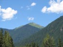
At the Sulphur Mountain turnoff, just a few minutes up the trail, we saw another trail heading down. Further sleuthing showed it to start down by the river. Was it a horse access? The road used to go a mile farther to the Milk Creek Trail. Was it access to the Sulphur Mountain Trail without parking on the old road? We have no idea. By now it was time for dinner. We could see Green Mountain from our campsite. Sitting by the river was a very nice place for dinner.
Before turning in we hiked back along the road to the Sulphur Creek Campgrounds. It was fitting to find a tree down by the entrance. Most sites are in good shape though one has a tree down across the picnic table. A few sites were damaged by the floods. The road has trees growing up to 5 feet tall in the middle. Near the Sulphur Creek Bridge we saw nine foot tall fireweed. I couldn't come close to reaching the tops. By far the largest ones I have ever seen. It was after 9:00 pm by the time we turned in.
Day two began with overcast skies. The clear sky at bedtime was now totally white. Still, there was a chance of rain and we had none of that. We ate then packed up our gear. We stashed it in the bathroom in case of rain or curious animals and set off with day packs for Sulphur Mountain. Kim hiked high on the mountain once before with Janet but snow turned them back. She also had done the lower part another time. This was my first visit to the end of the road. A few minutes up the Suiattle River Trail we came to the turn off and headed up.
The trail begins steeply. In fact, the fist quarter mile may be as steep as anything above. After a short climb we dropped down to a creek crossing It was the last water of the hike up. There has definitely been trail maintenance done in the last year. A brushy spot was completely brushed out. Most logs were cut. There were less than ten logs down across the trail on the whole route. Much nicer than we expected. This is a great trail. It is narrow but smooth. Almost no roots or rocks.
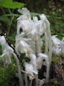
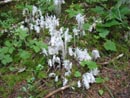
The trail goes through a myriad of eco zones. Always in dark forest it goes from valley floor with underbrush to no underbrush at all to heather meadow at the top. The constant changes keep it very interesting. There are very few really steep sections and each one is followed by a very moderate section. It's fairly steep but consistently graded and very easy to hike. At one point the route nears a large boulder field then drops a little to go beneath it. Here at just over 5000' we found tiger lilies blooming. In the darkest forest there are a number of fungus type plants like indian pipe. Very neat to see so many non green plants.
We had a very consistent pace, slowed only by much picture taking. We averaged about 1150' gained per hour. We finally exited the deep forest and saw the last few patches of snow. Heather was now the dominant plant. We switchbacked up to the final ridge and the views jumped out at us. Craggy North Cascades type peaks to the north. Sulphur Lake right down below us. A boot path left the ridge heading down towards the lake. A few minutes later we were on the first bump. The next one looked to be just a little higher. A short drop and climb brought us to the top. A marmot scurried away as we arrived.
Neither of us expected to find the top cloaked in a big rolling meadow. Heather and anemone were blooming along with a few other flowers. Clouds were swirling all around us. We could see a little of the base of Glacier Peak but the mountain was hidden in the clouds. This is a really close vantage point for Glacier. The actual summit of Sulphur came out ot the clouds. It was not all that far away but we did not have the time this day. What a terrific summit!
We ate and photographed and ate and took more photos. The clouds did obscure some phenomenal views but they added a moodiness as well. Not a drop of rain fell on us all day long. We spent about 45 minutes on top and would have loved to stay longer but a long descent and bike ride was still to come. The trip down was much quicker. Even with more photo stops we took an hour off our uphill time. We took 4 hours up and 3 hours to come down. The trailhead is at about 1600' and the top is at 6200'. The forest service web site and other trip reports call it 4200' of gain but my map shows it as 4600'. Add another 150' of ups and downs for a grand total of 4750'. Not a bad days work.
Finally back at our bikes we repacked our backpacks and took a final break. We were not sure how our legs would respond after all that elevation gain. The ride out proved to be a blast. We powered up each of the hills and coasted a good distance as well. It took 90 minutes to cover the 11 miles. By the end we were thoroughly tired. We saw a couple of motorcyclists at the end of the road and nobody else the whole weekend. Pretty good solitude. A stop back at the freeway for a late dinner and we were in Seattle by 10:30 pm.
This trip was completely Kim's idea and it turned out to be a great one. The bikes allowed us to go where few have been this year and the backpacking gear gave us the time to do some exploring. Sulphur Mountain turned out to be a terrific vantage point and the trail was in fine shape, especially considering that the road is washed out and few are getting back there. Terrific variety, a steep climb, a beat up bridge, and great company. It was a really fun weekend.
Click on thumbnails to get larger pictures.
Photo Page 2
Trips - 2007
Home
The next eight miles of road is fine. There are some short segments with sand on the road. The road gains about 700' net feet over the eleven miles. There are about 200' of downhill heading in making it about 900' in and 200' out. Carrying the overnight pack proved to not be a big problem. Kim and I chose to use low top trailrunner shoes for biking and hiking in lieu of carrying boots as well.
At the nine mile mark we reached Downey Creek. The left side of the road has now washed away leaving less dirt at the approach to the bridge. The old log built ladder is still there as well as a wooden ramp climbing the dozen feet or so up to the bridge deck. That was new since Kim's last visit. We poked around and found the start of the old Green Mountain trail. There are cut logs and then "newer" downed logs that look like they have been there for 30 years. It would be interesting to try and follow the old trail to the new start some 2 miles and 1800' above.
We also found an old outhouse and a strange flower that is five feet tall. After exploring we were able to walk our bikes right up the ramp and onto the bridge. Two more miles of biking brought us to the end of the road and the Suiattle River Trailhead. The old road below the trailhead sign drops quickly to the river. At that point it is asphalt. A mystery as to why the last dozen miles of road is gravel and the road to the river is paved. We set up camp on sand with a nice view of the roaring river.
With camp set we headed up the Suiattle River trail. Kim went up to Milk Creek after the 2003 flood and found the nearly new Milk Creek bridge some 2/10th of a mile down river. I wanted to see it as well. At the bridge site we could see the concrete foundation on the other side. On this side there is a small concrete and rebar piling and no footings at all left. We scrambled down to river level. We were able to follow the edge of the river part way then were forced inland. There is a large area of sand and new small trees growing in the river's flood plain. A little bushwhacking led us to the bridge. Just before it came into sight Kim said she could smell it. The bridge had new pressure treated lumber still attached.
The Milk Creek bridge was made out of steel I-Beams attached with numerous steel cross members. It was torn from it's concrete foundation, crushed together, and severely bent. It gives a good indication of the power of the river at it's massive full flood stage. We looked up and downstream and did not find a log across the river. Before we headed back up to the trail we were crossing some sand and Kim suddenly sank. It was quicksand right out of those bad old movies. After it initially covered her boots she was able to reach for solid ground and work her way out of it.
I took a stick and thrust it down into the muck. It sank a few inches and stopped. A little more pressure and it sank a full 8 or nine inches to the rock below. It would be a real chore to try and excavate yourself from what was more like cement than mud. That fun aside, we headed back to the trail. We looked for the sunglasses Kim lost a year earlier near the bridge site but were not lucky.
At the Sulphur Mountain turnoff, just a few minutes up the trail, we saw another trail heading down. Further sleuthing showed it to start down by the river. Was it a horse access? The road used to go a mile farther to the Milk Creek Trail. Was it access to the Sulphur Mountain Trail without parking on the old road? We have no idea. By now it was time for dinner. We could see Green Mountain from our campsite. Sitting by the river was a very nice place for dinner.
Before turning in we hiked back along the road to the Sulphur Creek Campgrounds. It was fitting to find a tree down by the entrance. Most sites are in good shape though one has a tree down across the picnic table. A few sites were damaged by the floods. The road has trees growing up to 5 feet tall in the middle. Near the Sulphur Creek Bridge we saw nine foot tall fireweed. I couldn't come close to reaching the tops. By far the largest ones I have ever seen. It was after 9:00 pm by the time we turned in.
Day two began with overcast skies. The clear sky at bedtime was now totally white. Still, there was a chance of rain and we had none of that. We ate then packed up our gear. We stashed it in the bathroom in case of rain or curious animals and set off with day packs for Sulphur Mountain. Kim hiked high on the mountain once before with Janet but snow turned them back. She also had done the lower part another time. This was my first visit to the end of the road. A few minutes up the Suiattle River Trail we came to the turn off and headed up.
The trail begins steeply. In fact, the fist quarter mile may be as steep as anything above. After a short climb we dropped down to a creek crossing It was the last water of the hike up. There has definitely been trail maintenance done in the last year. A brushy spot was completely brushed out. Most logs were cut. There were less than ten logs down across the trail on the whole route. Much nicer than we expected. This is a great trail. It is narrow but smooth. Almost no roots or rocks.
The trail goes through a myriad of eco zones. Always in dark forest it goes from valley floor with underbrush to no underbrush at all to heather meadow at the top. The constant changes keep it very interesting. There are very few really steep sections and each one is followed by a very moderate section. It's fairly steep but consistently graded and very easy to hike. At one point the route nears a large boulder field then drops a little to go beneath it. Here at just over 5000' we found tiger lilies blooming. In the darkest forest there are a number of fungus type plants like indian pipe. Very neat to see so many non green plants.
We had a very consistent pace, slowed only by much picture taking. We averaged about 1150' gained per hour. We finally exited the deep forest and saw the last few patches of snow. Heather was now the dominant plant. We switchbacked up to the final ridge and the views jumped out at us. Craggy North Cascades type peaks to the north. Sulphur Lake right down below us. A boot path left the ridge heading down towards the lake. A few minutes later we were on the first bump. The next one looked to be just a little higher. A short drop and climb brought us to the top. A marmot scurried away as we arrived.
Neither of us expected to find the top cloaked in a big rolling meadow. Heather and anemone were blooming along with a few other flowers. Clouds were swirling all around us. We could see a little of the base of Glacier Peak but the mountain was hidden in the clouds. This is a really close vantage point for Glacier. The actual summit of Sulphur came out ot the clouds. It was not all that far away but we did not have the time this day. What a terrific summit!
We ate and photographed and ate and took more photos. The clouds did obscure some phenomenal views but they added a moodiness as well. Not a drop of rain fell on us all day long. We spent about 45 minutes on top and would have loved to stay longer but a long descent and bike ride was still to come. The trip down was much quicker. Even with more photo stops we took an hour off our uphill time. We took 4 hours up and 3 hours to come down. The trailhead is at about 1600' and the top is at 6200'. The forest service web site and other trip reports call it 4200' of gain but my map shows it as 4600'. Add another 150' of ups and downs for a grand total of 4750'. Not a bad days work.
Finally back at our bikes we repacked our backpacks and took a final break. We were not sure how our legs would respond after all that elevation gain. The ride out proved to be a blast. We powered up each of the hills and coasted a good distance as well. It took 90 minutes to cover the 11 miles. By the end we were thoroughly tired. We saw a couple of motorcyclists at the end of the road and nobody else the whole weekend. Pretty good solitude. A stop back at the freeway for a late dinner and we were in Seattle by 10:30 pm.
This trip was completely Kim's idea and it turned out to be a great one. The bikes allowed us to go where few have been this year and the backpacking gear gave us the time to do some exploring. Sulphur Mountain turned out to be a terrific vantage point and the trail was in fine shape, especially considering that the road is washed out and few are getting back there. Terrific variety, a steep climb, a beat up bridge, and great company. It was a really fun weekend.
Bypassed Washout |
Kim Biking |
Washed Out |
Trail Bypass |
Buck Creek |
Small Washout |
Downey Bridge |
Second Outhouse |
Big Plant |
Kim Ramping Up |
Railing Torn Off |
Green Mountain |
Parking Lot |
Indian Pipe |
Big Patch Of Pipe |
Intact Bridge |
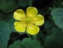
Yellow Flower |
River's Edge |
Milk Creek Bridge |
Bridge Remains |
Photo Page 2
Trips - 2007
Home