6-16-07
I joined Karen, Kim, and Steve for a return trip to
the Standup Creek trail off the Stafford Creek Road in the Teanaway area.
Rather than the usual race up Earl Peak this trip was more a case of stop
and smell the flowers. Or in this case, stop and photograph the flowers.
I have been here in the spring and enjoyed the flowers but this time they
were even better than I recalled. We met in Preston at 8:00 am and reached
the Standup Road intersection at about 9:40. There was a hand written sign
stating that a log blocked the road 1/2 mile up. The road is very narrow
with little chance to turn around in the first 1/2 mile so we chose to walk.
It's only 1 mile to the trailhead.
The road turned out to be in surprisingly good shape. There were several logs across the road and all had been recently cut out. There are half a dozen eroded dips but my Subaru could have handled them easily. Most cars could make it up. If in doubt the road walk is easy and goes fast. On my last visit in 2002 the road continued past the trailhead and on up to the old lookout site. Now the road ends at the trailhead and a foot bridge is in place where a culvert allowed cars to continue on. There is a trail sign at the footbridge but not one where the trail quickly leaves the road. The sign there has been removed. Do not walk far on the road. The trail starts almost immediately.
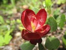
The flowers began with monkeyflowers at the edge of the parking lot. They continued almost without a break for the whole day. Tiger lilies and columbine were present early on. In fact, we saw the rare yellow columbine. It was a challenge to photograph them in the wind. There was enough to make photography difficult all day. The trail begins on an old road. When I began hiking this trail it was very much a road. It is now looking more and more like a trail as trees and brush narrow the route.
We made very slow progress as there was plenty of photos to take. It very soon was apparent that flower photos and not a summit was the goal for the day. There are seven creek crossings and in the spring they can be challenging. We all brought creek crossing shoes just in case. On the first one several of us rock hopped and several crossed on logs a little upstream. The flowers continued including lupine, indian paintbrush, vanilla leaf, nootka roses, honeysuckle, bead lily, bog orchid, waterleaf, larkspur, solomons seal, and more in the lower elevations.
Most of the other stream crossings were too wide to step across but we managed to get across with dry feet. The water was definitely lower then early June of 2002. After a steady gentle climb the trail got down to business. Much of the elevation gain is in the last half. While steeper it remains well graded all the way. The few very steep exceptions are in places where the trail at one time avoided a downed tree by going steeply up. Now the detour has become the new trail.
Elevation gain took us from the dense underbrush to more open country. Here the flowers changed to more paintbrush and dry soil flowers. A bit higher we reached balsamroot in full bloom. A flat spot gave us a chance for a food and water break. From here you can see up to near the summit of Earl Peak. We found several yellow and red paintbrush just above here. Just before the Standup/Bean trails intersection we found lots of shooting stars.
At the intersection we took a right turn. Our last crossing of the creek was an easy step across. The creek here is a series of waterfalls on a grassy hillside. We had sun much of the day but clouds were now coming in. The trail traverses the slope to the right and into forest. Here we found snow. The trail was increasingly snow covered here but still not hard to follow. Soon we were at the saddle. From this 6200' spot the trail drops to meet the Stafford Creek Trail. The other side of the ridge was snow free though there is still snow down in the Stafford basin.
We sat out of the wind to finish our lunch. Across the valley Miller, Little Navaho, Three Brothers, and Navaho were clear of clouds. McClellan Peak in the Stuart Range was also visible. The top of Little Annapuna and the other Stuart peaks were lost in the clouds. It was already past 2:30. The debate was whether to continue on to the summit of Earl or head straight back down. We decided to give Earl a shot.
We stayed below the ridge top where possible to reduce the wind. The summit was a little cloudy and light snow began to fall. Three of us still had shorts on but it was getting cold. At 6500' we went up to the ridge top and across to escape the wind. With the clouds and increasing wind we chose to turn around. Above the pass we did see douglasia, pasque flower, and a few other new flowers.
The drop to the pass went quickly. Rather than slog down the snow we went cross country to reach the trail. The rest of the descent was slow and steady. Carol and her boyfriend Scot passed us on the way down. Young knees went down much quicker than our group. We took many fewer photos on the way down. At long last we reached the trailhead. That just left the last mile of road. As always it seemed to have become much longer since the morning.
We stopped in Cle Elum for dinner. On the drive home it began to rain just west of Cle Elum. By Easton it was raining hard. It did not let up until near North Bend. A long wet drive home. In the Puget Sound area it was completely dry. At least we were not rained on that hard while on the trail. This was a very good flower hike. I had fun hiking with Karen and Kim again and for the first time with Steve. For the day we covered 11 miles with 3800' gained.
Click on thumbnails to get larger pictures.
Photo Page 2
Trips - 2007
Home
The road turned out to be in surprisingly good shape. There were several logs across the road and all had been recently cut out. There are half a dozen eroded dips but my Subaru could have handled them easily. Most cars could make it up. If in doubt the road walk is easy and goes fast. On my last visit in 2002 the road continued past the trailhead and on up to the old lookout site. Now the road ends at the trailhead and a foot bridge is in place where a culvert allowed cars to continue on. There is a trail sign at the footbridge but not one where the trail quickly leaves the road. The sign there has been removed. Do not walk far on the road. The trail starts almost immediately.
The flowers began with monkeyflowers at the edge of the parking lot. They continued almost without a break for the whole day. Tiger lilies and columbine were present early on. In fact, we saw the rare yellow columbine. It was a challenge to photograph them in the wind. There was enough to make photography difficult all day. The trail begins on an old road. When I began hiking this trail it was very much a road. It is now looking more and more like a trail as trees and brush narrow the route.
We made very slow progress as there was plenty of photos to take. It very soon was apparent that flower photos and not a summit was the goal for the day. There are seven creek crossings and in the spring they can be challenging. We all brought creek crossing shoes just in case. On the first one several of us rock hopped and several crossed on logs a little upstream. The flowers continued including lupine, indian paintbrush, vanilla leaf, nootka roses, honeysuckle, bead lily, bog orchid, waterleaf, larkspur, solomons seal, and more in the lower elevations.
Most of the other stream crossings were too wide to step across but we managed to get across with dry feet. The water was definitely lower then early June of 2002. After a steady gentle climb the trail got down to business. Much of the elevation gain is in the last half. While steeper it remains well graded all the way. The few very steep exceptions are in places where the trail at one time avoided a downed tree by going steeply up. Now the detour has become the new trail.
Elevation gain took us from the dense underbrush to more open country. Here the flowers changed to more paintbrush and dry soil flowers. A bit higher we reached balsamroot in full bloom. A flat spot gave us a chance for a food and water break. From here you can see up to near the summit of Earl Peak. We found several yellow and red paintbrush just above here. Just before the Standup/Bean trails intersection we found lots of shooting stars.
At the intersection we took a right turn. Our last crossing of the creek was an easy step across. The creek here is a series of waterfalls on a grassy hillside. We had sun much of the day but clouds were now coming in. The trail traverses the slope to the right and into forest. Here we found snow. The trail was increasingly snow covered here but still not hard to follow. Soon we were at the saddle. From this 6200' spot the trail drops to meet the Stafford Creek Trail. The other side of the ridge was snow free though there is still snow down in the Stafford basin.
We sat out of the wind to finish our lunch. Across the valley Miller, Little Navaho, Three Brothers, and Navaho were clear of clouds. McClellan Peak in the Stuart Range was also visible. The top of Little Annapuna and the other Stuart peaks were lost in the clouds. It was already past 2:30. The debate was whether to continue on to the summit of Earl or head straight back down. We decided to give Earl a shot.
We stayed below the ridge top where possible to reduce the wind. The summit was a little cloudy and light snow began to fall. Three of us still had shorts on but it was getting cold. At 6500' we went up to the ridge top and across to escape the wind. With the clouds and increasing wind we chose to turn around. Above the pass we did see douglasia, pasque flower, and a few other new flowers.
The drop to the pass went quickly. Rather than slog down the snow we went cross country to reach the trail. The rest of the descent was slow and steady. Carol and her boyfriend Scot passed us on the way down. Young knees went down much quicker than our group. We took many fewer photos on the way down. At long last we reached the trailhead. That just left the last mile of road. As always it seemed to have become much longer since the morning.
We stopped in Cle Elum for dinner. On the drive home it began to rain just west of Cle Elum. By Easton it was raining hard. It did not let up until near North Bend. A long wet drive home. In the Puget Sound area it was completely dry. At least we were not rained on that hard while on the trail. This was a very good flower hike. I had fun hiking with Karen and Kim again and for the first time with Steve. For the day we covered 11 miles with 3800' gained.
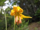
Tiger Lily |
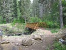
New Bridge |
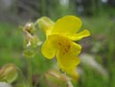
Monkeyflower |
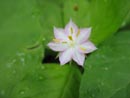
Tiny Flower |
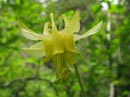
Yellow Columbine |
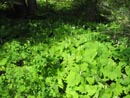
Vanilla Leaf |
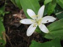
Queen's Cup |
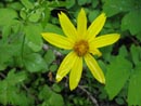
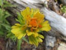
Arnica |
Mystery Flower |
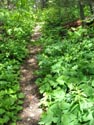
Narrow Trail |
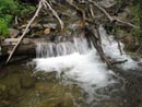
Standup Creek |
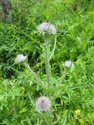
Thistle |
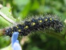
Caterpillar |
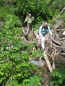
Creek Crossing |
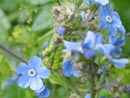
Forget-Me-Nots |
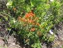
Orange Paintbrush |
Unusual Paintbrush |
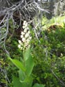
False Solomons Seal |
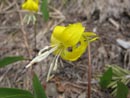
Glacier Lily |
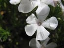
Phlox |
Photo Page 2
Trips - 2007
Home