8-25-07
The forecast as cold and rain for the Cascade crest
so we headed east. Summer is usually scorching in the Teanaway and I seldom
visit then unless everywhere else looks bad. Suzanne, Bob, and Kolleen joined
me for this adventure. None of them had ever done Teanaway or Bean Peaks
so that was an added bonus. We came in two cars so I thought a one way
trip with a car shuttle would be fun. We left one car at the Beverly Creek
trailhead and then drove back down to the NF Teanaway Road and on around
to the Iron Peak trailhead.
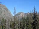
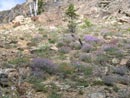
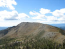
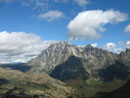
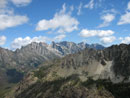
There were no other cars at the Iron Peak trailhead. I have been on top of Iron Peak more than a dozen times but only twice before via this trail. When last I was on this trail some 12 years earlier it was a little indistinct in places. Not any longer. Now it is very obvious all the way up. The day was mostly sunny as we climbed the trail up to the pass between Iron and Teanaway Peaks. The flowers are mostly gone by now but a few are hanging on.
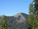
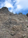
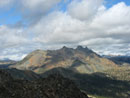
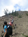
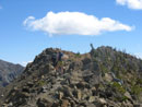
We took a break at the pass then began the scramble. We climbed up and to the right before dropping down to the main gully. Once across the gully we continued traversing to the right while trending upwards. Soon we found a bit of a bootpath. This route provides pretty easy access to the gentler ground above. Soon we were looking down on Iron Peak and across to Bean Peak. The scrambling is a little loose in places but if on route there is almost no exposure.
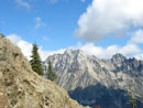
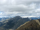
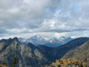
We aimed for the ridge to the right of the summit and then followed the ridge on to the top. Mt. Stuart was mostly in the clear with just a few small clouds near the top. The Cascade crest was buried in dark clouds. We were glad to have traveled this far east. The summit has the largest register tube I have seen. I first saw this one from Bill Peak. Gary and I could not believe we were seeing the register from so far away but when we headed over there we found it to be true.
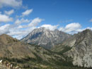
Teanaway Peak has one of the best views of Mt. Stuart. It is really up front and in your face. After a brief stay we headed on down. a few hundred feet below the summit we heard a voice asking "Is that you Bob?" It turned out to be GeoTom from nwhikers.net. He, his wife Dani, and Jasper the dog were heading up. What a strange place to run into someone. After exchanging pleasantries we headed back down. In short order we were back at the pass.
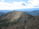
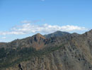
Just above the pass we met a large group of horse riders from Camp Wahoo. There were eight or nine of them. We continued on climbing higher along the summit ridge of Iron. I was last on Iron in early April when I camped on the summit. There was 8 to 10 feet of snow at that time. This day everything was brown. By the time we reached the top is was time for lunch. We had the two close peaks done but still had a ways to go to get to number three.
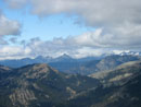
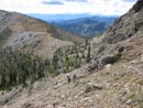
Iron does have great views. The crest still was in the clouds but Mt. Stuart was now completely in the clear. We soon headed on down. Instead of the 30 second glissade I get in the winter and spring it was a long walk on the trail. We passed Tom and Dani once again then dropped down from the pass. The trail is in fine shape and in no time we were down at the Fourth Creek intersection.
We turned left uphill and began the climb to Fourth Creek Pass. I pointed out the dirt and scree slope that leads up Bill Peak. None of the others have done that one either. Three summits were enough for this day so Bill will have to wait for another day. At the pass we turned right onto the County Line Trail. It was getting pretty hot and the late afternoon sun began to get to me. I felt like crap but kept on moving.
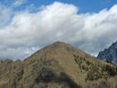
We stopped at the base of the final switchbacks to enjoy the view. Then it was on to the next pass. This one is right along the side of Volcanic Neck. At the pass the wind was now blowing hard. The others stopped to put on more clothes but I was enjoying the cool wind. In fact I began to feet much better. The ridge scramble up Bean is pretty easy. Stay on the ridge crest and avoid getting cut up by the sharp tree branches just below the ridge. I learned that lesson the hard way.
We reached the top to find nobody else there. Still mostly clear views. More food was consumed as we prepared for the final leg of our journey. It is all down hill from the summit of Bean to the Beverly Creek trailhead. Lots of folks descend via the ridge with Earl Peak. I prefer the direct approach. The face is very steep but has very good hand and foot holds. In just a few minutes we were down the face.
From there it is steep dirt and a little scree all the way down to Bean Creek Basin. We made pretty good time on the descent. In the basin we finally saw some other people. We had had several hours of solitude. The rest of the way was just a trail hike. It always seems much longer than the maps show. Back at the car we still had to drive back to the Iron Peak trailhead to pick up the other car.
On the drive home it began to rain before Easton and continued almost all the way to Issaquah. It was pouring at Snoqualmie Pass. I always enjoy a sunny day in the Teanaway when rain is falling hard at the crest. This day I had a chance to revisit three favorite summits and the others reached two brand new ones. Overall, a very nice day to be in the mountains.
Click on thumbnails to get larger pictures.
Photo Page 2
Trips - 2007
Home
There were no other cars at the Iron Peak trailhead. I have been on top of Iron Peak more than a dozen times but only twice before via this trail. When last I was on this trail some 12 years earlier it was a little indistinct in places. Not any longer. Now it is very obvious all the way up. The day was mostly sunny as we climbed the trail up to the pass between Iron and Teanaway Peaks. The flowers are mostly gone by now but a few are hanging on.
We took a break at the pass then began the scramble. We climbed up and to the right before dropping down to the main gully. Once across the gully we continued traversing to the right while trending upwards. Soon we found a bit of a bootpath. This route provides pretty easy access to the gentler ground above. Soon we were looking down on Iron Peak and across to Bean Peak. The scrambling is a little loose in places but if on route there is almost no exposure.
We aimed for the ridge to the right of the summit and then followed the ridge on to the top. Mt. Stuart was mostly in the clear with just a few small clouds near the top. The Cascade crest was buried in dark clouds. We were glad to have traveled this far east. The summit has the largest register tube I have seen. I first saw this one from Bill Peak. Gary and I could not believe we were seeing the register from so far away but when we headed over there we found it to be true.
Teanaway Peak has one of the best views of Mt. Stuart. It is really up front and in your face. After a brief stay we headed on down. a few hundred feet below the summit we heard a voice asking "Is that you Bob?" It turned out to be GeoTom from nwhikers.net. He, his wife Dani, and Jasper the dog were heading up. What a strange place to run into someone. After exchanging pleasantries we headed back down. In short order we were back at the pass.
Just above the pass we met a large group of horse riders from Camp Wahoo. There were eight or nine of them. We continued on climbing higher along the summit ridge of Iron. I was last on Iron in early April when I camped on the summit. There was 8 to 10 feet of snow at that time. This day everything was brown. By the time we reached the top is was time for lunch. We had the two close peaks done but still had a ways to go to get to number three.
Iron does have great views. The crest still was in the clouds but Mt. Stuart was now completely in the clear. We soon headed on down. Instead of the 30 second glissade I get in the winter and spring it was a long walk on the trail. We passed Tom and Dani once again then dropped down from the pass. The trail is in fine shape and in no time we were down at the Fourth Creek intersection.
We turned left uphill and began the climb to Fourth Creek Pass. I pointed out the dirt and scree slope that leads up Bill Peak. None of the others have done that one either. Three summits were enough for this day so Bill will have to wait for another day. At the pass we turned right onto the County Line Trail. It was getting pretty hot and the late afternoon sun began to get to me. I felt like crap but kept on moving.
We stopped at the base of the final switchbacks to enjoy the view. Then it was on to the next pass. This one is right along the side of Volcanic Neck. At the pass the wind was now blowing hard. The others stopped to put on more clothes but I was enjoying the cool wind. In fact I began to feet much better. The ridge scramble up Bean is pretty easy. Stay on the ridge crest and avoid getting cut up by the sharp tree branches just below the ridge. I learned that lesson the hard way.
We reached the top to find nobody else there. Still mostly clear views. More food was consumed as we prepared for the final leg of our journey. It is all down hill from the summit of Bean to the Beverly Creek trailhead. Lots of folks descend via the ridge with Earl Peak. I prefer the direct approach. The face is very steep but has very good hand and foot holds. In just a few minutes we were down the face.
From there it is steep dirt and a little scree all the way down to Bean Creek Basin. We made pretty good time on the descent. In the basin we finally saw some other people. We had had several hours of solitude. The rest of the way was just a trail hike. It always seems much longer than the maps show. Back at the car we still had to drive back to the Iron Peak trailhead to pick up the other car.
On the drive home it began to rain before Easton and continued almost all the way to Issaquah. It was pouring at Snoqualmie Pass. I always enjoy a sunny day in the Teanaway when rain is falling hard at the crest. This day I had a chance to revisit three favorite summits and the others reached two brand new ones. Overall, a very nice day to be in the mountains.
Fortune Peak |
Koppen Mountain |
Flowers At The Pass |
Start Of Scramble |
Iron Peak |
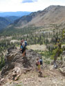
Photo Break |
First Stuart View |
Cloudy |
Mt. Stuart |
Fortune & Ingalls |
Hawkins Mountain |
Cascade Crest |
Stuart Range |
Heading Down |
Saddle Ahead |
Teanaway Peak |
Nearing Iron Summit |
Mt. Daniel |
Stuart Over Pass |
Bean Peak |
Photo Page 2
Trips - 2007
Home