2-02-08
What a week! Five feet of fresh snow in the mountains.
Snoqualmie Pass closed down for half the week. Sno-parks closed down for
the weekend. Extreme avalanche danger everywhere. Where to go? After a decade
or more of procrastinating, I finally hiked on Blanchard Hill to Oyster
Dome in 2005. It is low and close to Puget Sound. It seemed to be a place
to face a reasonable amount of snow and no avalanche danger. Suzanne and
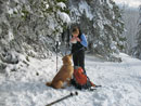
Gusto joined me. We headed out of Seattle at 8:15. Take exit 240 off I-5,
turn left under the freeway, and turn left again very quickly on Barrel
Springs Road. In only .60 mile turn right at the Blanchard Hill Trail sign.
We hit snow almost as soon as we left the freeway.
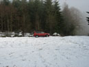
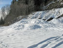
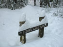
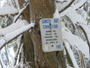
Just before the lower trailhead the road makes a switchback right and climbs steeply to another switchback left. This part was all snow. A car was turning around at the bottom of the hill as we approached. We made it up the hill fine with all wheel drive. The 700' elevation parking lot was all snow and slush. As we were getting ready the two guys in the car reached the trailhead. On my earlier visit I could not find the trail. Now there is a small sign saying the trail is 300 feet down the road.
We were on the trail by around 9:45. The route begins with a short mile hike to the upper trailhead. There was snow on the trail from the lower parking lot. At the upper lot there was more snow. We chose to take the road route up to the Alternate Incline Trail. I recall finding a gate a fair way up the road three years earlier. Now the gate is right at the upper trailhead. There were tire tracks beyond the gate. The snow rapidly grew deeper. Soon we saw ski tracks in the tire ruts.
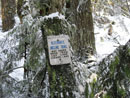
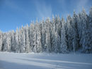
The snow was soon 5 then 6 then 7 inches deep. It was cloudy when we started but we were now out in bright sunshine. Below us we could see low clouds. So much for the forecast of overcast with showers. On my earlier visit there was no marker for the Incline Trail, just an obvious small dirt path. I was a little concerned with finding it in all the snow. The ski tracks ended and there were no other footprints. We found a small metal trail marker on the side of the road. Into the forest we went.
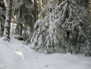
A short distance into the forest is a much larger sign for the Incline Trail and the Alternate Incline Trail. The alternate is longer but less steep. Instead of climbing up the fall line it makes a number of gentle switchbacks. We took the alternate. I expected the snow to be much less deep in the dense forest. Not so. The snow was deep and getting deeper with small increases in elevation. We brought snowshoes but since the high point of the day was only about 2000' and right above salt water, we chose not to carry them. There were a few times they might have been useful. The snow was so powdery that we were able to slog through pretty easily.
Lower down the trees were dripping and dropping flumph bombs but as we ascended it cooled down to around 32 degrees and they bombs lessened. At one point the Alternate Incline Trail began a flat leg to the left. It sure seemed like a railroad grade. Like the one over to Lily Lake on the Pacific Northwest Trail. I suggested we go back to the start of the flat spot and look for a trail right that might be the way to Lizard Lake. We found what looked like more of the railroad grade but no signs. Off we went on this new section.
We were more out in the open here. That meant deep and soft snow. Crotch deep postloling ensued. Somehow Gusto managed to walk right along in the deep holes. After about 10 minutes and not much distance a big log blocked our way. This seemed less and less like the way to Lizard Lake. We chose to head back and continue on our original route. That route continued mostly flat and in a short time we reached the junction with the PNT. It was well signed with Lily Lake to the left and Lizard Lake to the right.
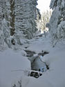
We went right and headed to Lizard Lake. It is not far at all and even slogging in deeper snow it did not take long to arrive. I was here in early spring before and the lake was high with skunk cabbage along the shore. This time it was completely snow covered. A little blue sky overhead really set off the bright white snow on the lake. One lake down and one to go. We headed back to the junction and continued on towards Lily Lake. The PNT is pretty flat from Lizard Lake to Lily Lake at about 2000'. That is also about the elevation of Oyster Dome. Most of our climbing was over for the day.
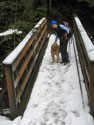
There are a few large trees down across the trail. We managed to go under or around them without too much trouble. Since they still have branches it was a bit wet pushing through a few of them. A few bridges were noticeable though under lots of snow. We came to another intersection with Lizard and Lily Lakes signs. The left turn had no footprints. I guessed this was the Lily Lake Trail coming up from the upper parking area. If so, this would be an optional way back down. I sign would be useful here. So would remembering no to leave the map in the car.
A few minutes later we reached a very confusing sign. It had distances to eight different locations but no arrows. The distances did not seem to make sense either. 1 1/2 miles to North Butte? Last time I climbed up a short way from Lily Lake and we were almost there. We headed on and reached the Lily Lake junction next. Suzanne suggested visiting now rather than on the return leg. The snow was deeper here. I remembered big beaver dams near this point and reading that they were since gone. In fact, there was no trace of the dams.
We slogged on to Lily Lake. We crossed the outlet to the camping area and went to the lake shore. Very blue sky now and all snow on the lake. It was now well past noon and we had a bit to eat before heading on. Back at the junction we headed west towards Oyster Dome. Curiously, no trail signs on the east side of the hill mention Oyster Dome. Even the map at the trailhead did not show it. Finally we had directions. The route parallels the Lily outlet creek on an old road. We had to work our way around the snow plastered trees in places.
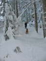
The route crossed the creek to the left side and continued a gentle descent. There were no tracks at all and Suzanne did a good job of staying on route. We dropped right, crossed the creek again, and climbed to an unsigned junction. A trench came up on our left and continued ahead. This was definitely the Oyster Dome route from Chuckanut Drive. We now had a last climb up to the dome. It was steep in a few places but no trouble with good traction in the snow. When it thaws and freezes a few times this could get really icy.
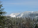
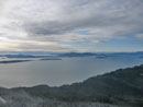
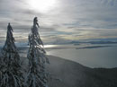
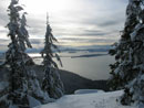
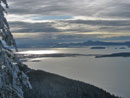
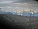
In short order we popped out at Oyster Dome. There was a group descending and another group enjoying the view. We stopped and chatted while breaking out our cameras. It was not as clear as it had been most of the day but also not all cloudy either. The San Juan Islands were laid out below us. The rock slab viewpoints were completely snow covered. Out of the forest and into the sun it seemed much warmer. The group left and a few others arrived. We arrived at 1:45 and spent half an hour. It took us four hours to reach Oyster Dome and I did want to get back to the car before dark.
At 2:15 we packed up and headed down. With a nice trench in place we made good time. In 36 minutes we were back at what I thought was the Lily Lake Trail. Still no footprints. I had hoped the two guys who were right behind us when we began the hike would have come up this route. Now we had a choice. Take the route we came up and definitely get down before dark or take the trail we were unsure about and hope it led back to the upper parking lot. We chose the latter.
The trail is very gently graded and built to confuse. We knew the parking lot was roughly below us. A series of switchbacks would have made perfect sense. That was not the case. The route does make a few switchbacks then begins a long long traverse to the right. I was beginning to fear we would come out on Chuckanut Drive far from the car. Finally, with salt water now in sight, it switched back and began a long long traverse to our left. In time we could see the road below us. We must be almost to the upper parking lot. Not so fast. We followed that road forever. We descended but never got closer. A long time later we finally reached the road.
A short uphill road walk brought us to the upper parking lot. We had met two women part way down the Lily Lake Trail who confirmed we were on the right route. Two cars were in the snow covered lot. The road had two ruts all the way down to bare dirt. It seemed there was a lot of melting while we were hiking. One more mile of hiking brought us back to the lower parking lot.
This was a fun day hike. We avoided all avalanche danger. We did not have to worry about sinking shoulder deep in all the new snow. We did have about as much snow as 2000' elevation on the shores of Puget Sound will ever give you. Other than at Oyster Dome we saw very few people. It was fun to puzzle out the route. My one earlier visit helped but it sure looked different under a foot or two of snow. The view from Oyster Dome really is nice. All in all, a very nice day to avoid the mountains and hike in the hills.
Suzanne's report with photos is here: Nwhikers report and photos .
Click on thumbnails to get larger pictures.
Trips - 2008
Home
Just before the lower trailhead the road makes a switchback right and climbs steeply to another switchback left. This part was all snow. A car was turning around at the bottom of the hill as we approached. We made it up the hill fine with all wheel drive. The 700' elevation parking lot was all snow and slush. As we were getting ready the two guys in the car reached the trailhead. On my earlier visit I could not find the trail. Now there is a small sign saying the trail is 300 feet down the road.
We were on the trail by around 9:45. The route begins with a short mile hike to the upper trailhead. There was snow on the trail from the lower parking lot. At the upper lot there was more snow. We chose to take the road route up to the Alternate Incline Trail. I recall finding a gate a fair way up the road three years earlier. Now the gate is right at the upper trailhead. There were tire tracks beyond the gate. The snow rapidly grew deeper. Soon we saw ski tracks in the tire ruts.
The snow was soon 5 then 6 then 7 inches deep. It was cloudy when we started but we were now out in bright sunshine. Below us we could see low clouds. So much for the forecast of overcast with showers. On my earlier visit there was no marker for the Incline Trail, just an obvious small dirt path. I was a little concerned with finding it in all the snow. The ski tracks ended and there were no other footprints. We found a small metal trail marker on the side of the road. Into the forest we went.
A short distance into the forest is a much larger sign for the Incline Trail and the Alternate Incline Trail. The alternate is longer but less steep. Instead of climbing up the fall line it makes a number of gentle switchbacks. We took the alternate. I expected the snow to be much less deep in the dense forest. Not so. The snow was deep and getting deeper with small increases in elevation. We brought snowshoes but since the high point of the day was only about 2000' and right above salt water, we chose not to carry them. There were a few times they might have been useful. The snow was so powdery that we were able to slog through pretty easily.
Lower down the trees were dripping and dropping flumph bombs but as we ascended it cooled down to around 32 degrees and they bombs lessened. At one point the Alternate Incline Trail began a flat leg to the left. It sure seemed like a railroad grade. Like the one over to Lily Lake on the Pacific Northwest Trail. I suggested we go back to the start of the flat spot and look for a trail right that might be the way to Lizard Lake. We found what looked like more of the railroad grade but no signs. Off we went on this new section.
We were more out in the open here. That meant deep and soft snow. Crotch deep postloling ensued. Somehow Gusto managed to walk right along in the deep holes. After about 10 minutes and not much distance a big log blocked our way. This seemed less and less like the way to Lizard Lake. We chose to head back and continue on our original route. That route continued mostly flat and in a short time we reached the junction with the PNT. It was well signed with Lily Lake to the left and Lizard Lake to the right.
We went right and headed to Lizard Lake. It is not far at all and even slogging in deeper snow it did not take long to arrive. I was here in early spring before and the lake was high with skunk cabbage along the shore. This time it was completely snow covered. A little blue sky overhead really set off the bright white snow on the lake. One lake down and one to go. We headed back to the junction and continued on towards Lily Lake. The PNT is pretty flat from Lizard Lake to Lily Lake at about 2000'. That is also about the elevation of Oyster Dome. Most of our climbing was over for the day.
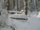
There are a few large trees down across the trail. We managed to go under or around them without too much trouble. Since they still have branches it was a bit wet pushing through a few of them. A few bridges were noticeable though under lots of snow. We came to another intersection with Lizard and Lily Lakes signs. The left turn had no footprints. I guessed this was the Lily Lake Trail coming up from the upper parking area. If so, this would be an optional way back down. I sign would be useful here. So would remembering no to leave the map in the car.
A few minutes later we reached a very confusing sign. It had distances to eight different locations but no arrows. The distances did not seem to make sense either. 1 1/2 miles to North Butte? Last time I climbed up a short way from Lily Lake and we were almost there. We headed on and reached the Lily Lake junction next. Suzanne suggested visiting now rather than on the return leg. The snow was deeper here. I remembered big beaver dams near this point and reading that they were since gone. In fact, there was no trace of the dams.
We slogged on to Lily Lake. We crossed the outlet to the camping area and went to the lake shore. Very blue sky now and all snow on the lake. It was now well past noon and we had a bit to eat before heading on. Back at the junction we headed west towards Oyster Dome. Curiously, no trail signs on the east side of the hill mention Oyster Dome. Even the map at the trailhead did not show it. Finally we had directions. The route parallels the Lily outlet creek on an old road. We had to work our way around the snow plastered trees in places.
The route crossed the creek to the left side and continued a gentle descent. There were no tracks at all and Suzanne did a good job of staying on route. We dropped right, crossed the creek again, and climbed to an unsigned junction. A trench came up on our left and continued ahead. This was definitely the Oyster Dome route from Chuckanut Drive. We now had a last climb up to the dome. It was steep in a few places but no trouble with good traction in the snow. When it thaws and freezes a few times this could get really icy.
In short order we popped out at Oyster Dome. There was a group descending and another group enjoying the view. We stopped and chatted while breaking out our cameras. It was not as clear as it had been most of the day but also not all cloudy either. The San Juan Islands were laid out below us. The rock slab viewpoints were completely snow covered. Out of the forest and into the sun it seemed much warmer. The group left and a few others arrived. We arrived at 1:45 and spent half an hour. It took us four hours to reach Oyster Dome and I did want to get back to the car before dark.
At 2:15 we packed up and headed down. With a nice trench in place we made good time. In 36 minutes we were back at what I thought was the Lily Lake Trail. Still no footprints. I had hoped the two guys who were right behind us when we began the hike would have come up this route. Now we had a choice. Take the route we came up and definitely get down before dark or take the trail we were unsure about and hope it led back to the upper parking lot. We chose the latter.
The trail is very gently graded and built to confuse. We knew the parking lot was roughly below us. A series of switchbacks would have made perfect sense. That was not the case. The route does make a few switchbacks then begins a long long traverse to the right. I was beginning to fear we would come out on Chuckanut Drive far from the car. Finally, with salt water now in sight, it switched back and began a long long traverse to our left. In time we could see the road below us. We must be almost to the upper parking lot. Not so fast. We followed that road forever. We descended but never got closer. A long time later we finally reached the road.
A short uphill road walk brought us to the upper parking lot. We had met two women part way down the Lily Lake Trail who confirmed we were on the right route. Two cars were in the snow covered lot. The road had two ruts all the way down to bare dirt. It seemed there was a lot of melting while we were hiking. One more mile of hiking brought us back to the lower parking lot.
This was a fun day hike. We avoided all avalanche danger. We did not have to worry about sinking shoulder deep in all the new snow. We did have about as much snow as 2000' elevation on the shores of Puget Sound will ever give you. Other than at Oyster Dome we saw very few people. It was fun to puzzle out the route. My one earlier visit helped but it sure looked different under a foot or two of snow. The view from Oyster Dome really is nice. All in all, a very nice day to avoid the mountains and hike in the hills.
Suzanne's report with photos is here: Nwhikers report and photos .
Snowy Parking Lot |
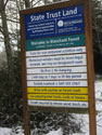
Trailhead Sign |
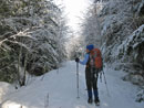
On The Trail |
Upper Parking Lot |
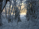
Shadows |
View Out |
Alt Incline Trail |
Truffel Digger |
Blocking Branch |
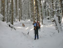
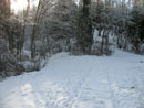
Navigating |
Snowy Log |
Lizard Lake |
Junction |
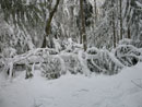
Log Across Trail |
Side Trail |
Open Water |
Lily Lake |
Oyster Sign |
Oyster Dome View |
View Southwest |
Rapt Attemtion |
Forested View |
One Last Dome View |
Bridge |
Last Look |
Trips - 2008
Home