12-6-08
Snow in the
mountains is melting
away in early December. Looks like we can get in another snow free
hike. Suzanne, Barry, and I planned to meet Bob, Kolleen, a couple of
Bob's co-workers at the Mason Lake Trailhead. The true summit of
Bandera Mountain would be the goal. On the drive Bob and Kolleen called
to say their friends were late. They suggested we go on and they would
do some other trip. Now our destination went back into play. Barry
wanted to hike up Putrid Pete's Peak (P³) and run the ridge over to Mt.
Defiance. From there complete the loop via Mason Lake. He had done it
once before. Suzanne and I had been up Putrid Pete's once too. An
alternate plan was in place.
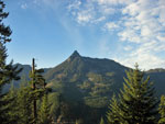
We reached the trailhead at 8:40 and within 10 minutes we were on the trail. There were already half a dozen cars in the Ira Spring Trail parking lot. The forecast was for clouds turning to rain in the afternoon. We hoped to be on the Defiance Trail heading down before the deluge began. Strangely, it was bright sunshine when we started. Within ten minutes up trail we came to the switchback where the Putrid Pete route goes straight ahead leaving the main trail. This way trail is more like a real trail at first.
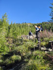
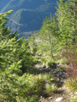
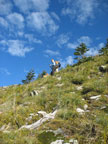
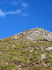
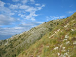
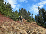
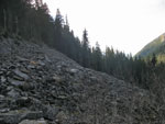
We began to slowly ascend. Farther along the route steepened. After the junction with trail to Dirty Harry's (right uphill to Pete) the trail narrows and gets steeper. Soon the real fun begins. When the trail started to descend Barry went back and found the less obvious uphill track we needed. The route is more up less straight up from where we left the forest. My recollection is that this is about as steep a trail as I have been on. Well, I still feel that way. There is some tread, some footprints and some pulling yourself up the slope hanging onto small trees. There is no real exposure it's just steep.
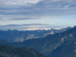
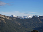
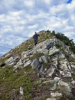
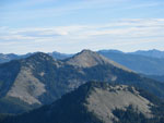
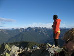
Barry blasted out ahead, Suzanne was next and I was pulling up the rear. All the usual folks that go my speed were other places. I started with a light shirt with a heaving wool shirt. Half way up I was down to the undershirt with the sleeves rolled up. It was 39 degrees when we started but it felt like September not December heading uphill. The wind picked up near the top and the heavy shirt went back on at the summit. The very top is not very big but there is plenty of room just below. Some clouds were coming in now but it was still mostly sunny. We had great views all around. Glacier Peak had some clouds but that was it. Right below us we could see the parking lot. Maybe two miles and 3150 vertical feet away. It took me a little over two hours to summit.
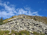
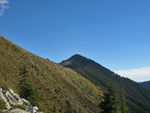
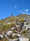
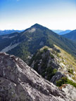
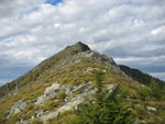
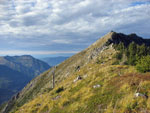
Looking down the ridge to Mt. Defiance it did not look all that hospitable. Not too bad but not all that easy either. In fact it was much easier than expected. We dropped down a little and side hilled around the first bump. From there we were able to stay on the ridge top all the way across. In places there was a lane through trees. Either animals have carved it out or someone has been maintaining the route. From the low spot we headed uphill soon reaching the Defiance Trail. Instead of following the trail to the Mt. Defiance summit spur we crossed over the trail and followed a "sort of" footpath up the ridge. We intersected the summit spur.
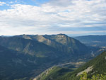
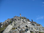
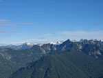
From there it wasn't too far to the top. Two other groups were already there. One person was an old friend of Suzanne's. It's a small world. The other group was two women who followed our trip reports online. A good time was had over lunch. We had similar views from Defiance plus a number of lakes. Thus far we had seen only a few tiny snow patches. There was a lot more a few weeks ago. At 1:00 pm we packed up and headed down.
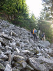
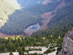
My knee was a little sore and we had steep downhill to come. Nothing remotely as steep as what we had ascended in the morning. We made good time on the way to Mason Lake. We also passed several more groups heading up Mt. Defiance. I was surprised to see a group just beyond the lake heading up at 1:30. I doubt they made it out before dark. At the lake Gusto the dog took a jump into the lake. He never met a lake he didn't want to swim in. After the lake we chose the old Mason Lake Creek Trail. It is steeper but shorter than the new trail. It's still in remarkably good shape.
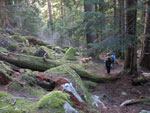
I was slower on the steep parts. There were the usual big downed trees to crawl over and under but not many new ones. It was not as muddy as I expected. At long last we popped out on the main trail about a mile from the end. I finished at about 3:10. We were back more than an hour before darkness. Since the Putrid Pete Trail is not on any maps I had to guesstimate the distance. The whole loop was about 9 miles and elevation gain was about 3900'.
We should not be doing 5500' summits in December with no snow. Not only that it was warm. Short sleeve warm. The ridge walk was new for me and it's a classic. Great views all along the way. Turning Mt. Defiance into a loop trip was fun too. The rain never did happen. It was a warm clear day to enjoy one more late season snow free hike.
Suzanne's report is here: Nwhikers Report & Photos
Click on thumbnails to get larger pictures.
Trips - 2008
Home
We reached the trailhead at 8:40 and within 10 minutes we were on the trail. There were already half a dozen cars in the Ira Spring Trail parking lot. The forecast was for clouds turning to rain in the afternoon. We hoped to be on the Defiance Trail heading down before the deluge began. Strangely, it was bright sunshine when we started. Within ten minutes up trail we came to the switchback where the Putrid Pete route goes straight ahead leaving the main trail. This way trail is more like a real trail at first.
We began to slowly ascend. Farther along the route steepened. After the junction with trail to Dirty Harry's (right uphill to Pete) the trail narrows and gets steeper. Soon the real fun begins. When the trail started to descend Barry went back and found the less obvious uphill track we needed. The route is more up less straight up from where we left the forest. My recollection is that this is about as steep a trail as I have been on. Well, I still feel that way. There is some tread, some footprints and some pulling yourself up the slope hanging onto small trees. There is no real exposure it's just steep.
Barry blasted out ahead, Suzanne was next and I was pulling up the rear. All the usual folks that go my speed were other places. I started with a light shirt with a heaving wool shirt. Half way up I was down to the undershirt with the sleeves rolled up. It was 39 degrees when we started but it felt like September not December heading uphill. The wind picked up near the top and the heavy shirt went back on at the summit. The very top is not very big but there is plenty of room just below. Some clouds were coming in now but it was still mostly sunny. We had great views all around. Glacier Peak had some clouds but that was it. Right below us we could see the parking lot. Maybe two miles and 3150 vertical feet away. It took me a little over two hours to summit.
Looking down the ridge to Mt. Defiance it did not look all that hospitable. Not too bad but not all that easy either. In fact it was much easier than expected. We dropped down a little and side hilled around the first bump. From there we were able to stay on the ridge top all the way across. In places there was a lane through trees. Either animals have carved it out or someone has been maintaining the route. From the low spot we headed uphill soon reaching the Defiance Trail. Instead of following the trail to the Mt. Defiance summit spur we crossed over the trail and followed a "sort of" footpath up the ridge. We intersected the summit spur.
From there it wasn't too far to the top. Two other groups were already there. One person was an old friend of Suzanne's. It's a small world. The other group was two women who followed our trip reports online. A good time was had over lunch. We had similar views from Defiance plus a number of lakes. Thus far we had seen only a few tiny snow patches. There was a lot more a few weeks ago. At 1:00 pm we packed up and headed down.
My knee was a little sore and we had steep downhill to come. Nothing remotely as steep as what we had ascended in the morning. We made good time on the way to Mason Lake. We also passed several more groups heading up Mt. Defiance. I was surprised to see a group just beyond the lake heading up at 1:30. I doubt they made it out before dark. At the lake Gusto the dog took a jump into the lake. He never met a lake he didn't want to swim in. After the lake we chose the old Mason Lake Creek Trail. It is steeper but shorter than the new trail. It's still in remarkably good shape.
I was slower on the steep parts. There were the usual big downed trees to crawl over and under but not many new ones. It was not as muddy as I expected. At long last we popped out on the main trail about a mile from the end. I finished at about 3:10. We were back more than an hour before darkness. Since the Putrid Pete Trail is not on any maps I had to guesstimate the distance. The whole loop was about 9 miles and elevation gain was about 3900'.
We should not be doing 5500' summits in December with no snow. Not only that it was warm. Short sleeve warm. The ridge walk was new for me and it's a classic. Great views all along the way. Turning Mt. Defiance into a loop trip was fun too. The rain never did happen. It was a warm clear day to enjoy one more late season snow free hike.
Suzanne's report is here: Nwhikers Report & Photos
 McClellan Butte |
 Talus Trail |
 Out Of The Forest |
 Looking Down |
 Steeper |
 Rocky Slope |
 Mt. Defiance |
 Washington & Balcony |
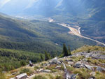 Parking Lot |
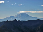 Mt. Rainier |
 Summit In Sight |
 Putrid Pete's Peak |
 A Few Clouds |
 Barry On Top |
 Glacier Peak |
 Daniel & Hinman |
 Banana Ridge |
 Thompson Lake |
 On The Ridge |
 Looking Back To P3 |
 Slope Of Ascent |
 Off Ridge Top |
 View Northeast |
 Pratt & Granite |
 Summit Of Defiance |
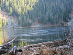 Mason Lake |
 Boulder Field |
 Old Mason Creek Trail |
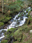 Waterfall |
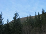 P³ From Parking Lot |
Trips - 2008
Home