3-08-08
A few years ago Matt posted a report of a snowshoe
scramble of Red Top Lookout starting from the North Fork Teanaway River
Road. It was long with a lot of elevation gain but it looked like a great
trip. We had kicked this idea around for some time. It is mostly a ridge
walk so we wanted a day with little wind and clear skies. Also, because of
the length we needed the longer days of late winter. With a forecast of
40% chance of snow in the morning and partly cloudy in the afternoon we
decided this was the time.
The National Weather Service has been wildly pessimistic for the last year. Every week has been better than forecast. This has been especially true on the east side of the mountains. If we believed the forecast we would never go out. Once again the norm proved to be true. Barry, Suzanne, and I met in North Seattle at 6:15 AM and Bob, Kolleen, David, and Jack met in Bellevue at 6:30. There was not much traffic at that hour and we cruised up the Teanaway Road arriving at about 8:00 AM.
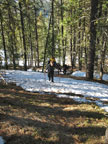
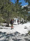
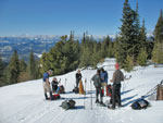
There is precious little parking as the snow is almost up to the road on both sides. The only space we could find was right where we wanted to start. The Indian Creek Road is right at the 11 mile marker. There was room for three cars. The sign on the gate says "Do Not Block Gate" though the road after the gate is under a foot of snow. We managed to squeeze in so there was access to the gate. It was in the high 20s with absolutely blue sky. So much for the forecast.
David arrived with the others at about 8:15. By 8:35 we were packed up and on our way. We walked down the road crossing Indian Creek then headed onto the snow. The snow was rock hard so we kept our snowshoes on our packs to start. Matt listed the route as 13 miles round trip with 4200' of gain. The trailhead is at 2400' and the summit is at 5361'. That meant there was some 600' of downs on the way in and 600' of ups on the way out. His group took almost 10 hours round trip with only 20 minutes on the summit. We knew it would be a long day.
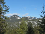
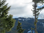
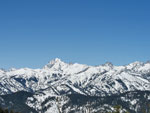
Route finding is not too hard. Matt's map helped as well. His report can be found here: Red Top Scramble . The way begins fairly flat then starts to climb. We went over one bump, descended, then began to climb again. Views out to Mt. Stuart and many Teanaway Peaks occur very quickly. Higher on the ridge most views are down the valley and not out towards Mt. Stuart. Summit views more than make up for this though.
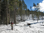
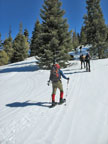
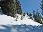
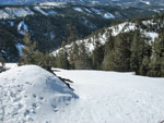
All too soon we began to post hole as the snow softened. In fact as we climbed out of the valley bottom it began to warm up fast. We were mostly in forest as we climbed up some moderately steep slopes. It was never uncomfortably steep. We crossed a road several times. We would find a number of roads before the day was done. Few were on our maps. We reached a big opening that appeared to be a logging landing then it was right back into the forest. The grade eased substantially as the ridge narrowed.
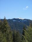
An opening in the forest gave us a view up to the lookout. It still looked to be a long distance away. Views opened up to the south and west. We were surprised to find a road. It was just below the ridge top and made walking even easier. We crested point 4238 and had a gentle descent. The road kept descending but the ridge now headed steeply up. We traversed from the road over to the low saddle in the ridge. The slope looked extremely steep with cliffs at the top. It was not quite as steep as it looked.
We headed up on hard snow that the snowshoes bit into well. We angled right and then had to make a near level traverse to the far right ridge. The snow was good and we had no trouble. One final steeper section and we were on another ridge top hump. Things became more interesting in the next section. The ridge was very narrow as we followed on the very top or just below to get around obstacles. In one place some of us took out ice axes to do a short descending traverse with some exposure.
We took Matt's advice and as we neared Point 4993 we went right side hilling around the point. The footing was pretty good in snowshoes as it was soft enough to get pretty solid steps. This took us the the saddle just south of 4993. There is a road heading east from the pass. We should have taken it. Instead we climbed up a slope to the southeast. This soon brought us to a point dropping steeply to the south and east . To the north it was more gentle. We took this route straight down and met up with the road.
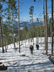
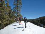
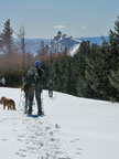
The road dropped to a valley floor and then climbed up the other side. A short way up we left the road and climbed straight up to Teanaway Ridge. This was moderately steep at the bottom but soon became quite gentle as it neared the ridge. I think most of us were getting worn out as we had been climbing consistently for over 4 hours. At the top of the ridge we broke out of the forest and into bright sunshine. Great views to the east. We could see most of our Tronsen Ridge route the weekend before.
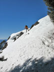
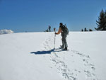
The ridge is wide and made for easy walking. A few ups and downs and the lookout came into view. We knew there was a 20' step to get onto the summit ridge and from this angle there did not seem to be any easy way to get up there. The ridge dropped a little and then entered forest for the last bit of climbing. As the ridge narrowed down we dropped snowshoes and traded one or both poles for ice axes. Bob and Barry went out ahead to scout the route. The snow was well consolidated but soft in spots. I headed up behind the leaders.
Bob led up into a narrow gully. I could not see the top. A few minutes later he called out that it looked like it would go and on we went. In the gully itself the snow was loose. Footsteps were deep though giving us a sense of security. I tried hard not to break out the steps as we hoped to use them on the descent. A few minutes later I exited the gully and stepped onto the summit ridge. The lookout was just above and Bob was out on the rock of the false summit. The ridge narrowed in the middle but was still a good six feet wide. The drop off on both sides was impressive.
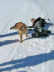
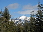
I visited Red Top one time many years ago. It was by car with a 10 minute walk from the trailhead. I can verify that it is much more impressive in the winter. One by one our group popped up the gully onto the ridge. Suzanne was worried about her dog Gusto but he rambled right up the gully with his four paw drive. Views from the top are spectacular. The Stuart Range and most all the Teanaway Peaks are laid out to the west. They are very beautiful when cloaked in snow. It took us 4:47 to summit. That was 63 minutes less than Matt's Mountaineer group but still a long time.
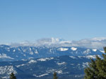
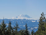
We had a nice break for lunch and photos from the top. Still in less than half an hour it was time to get moving. I sure would like to spend a night in that lookout in the winter. What a sunset and sunrise you would have. A few clouds were above mostly near Mt. Rainier and the Cascade crest. It was still beautiful over the Teanaway area. We had no problems descending the gully and were back on the lower ridge.
Our trip down went pretty well. My only real concern was descending the steep slope from near 4600' to the road down at about 4150'. The snow had softened significantly and we were able to take off our snowshoes and plunge step all the way down. It was even too soft for any glissading. At the bottom we put snowshoes back on and climbed up the road to where we left it for the ridge top again. With about a mile to go we managed to lose our tracks and headed too far north. With map and GPS we rambled below the ridge top until we ran into Indian Creek.
One small snow bridge held our weight and we were on the Indian Creek Road. Less than half a mile later we reached the cars. It was 5:30 PM, about 9 hours after our start. Still , we beat darkness by about 45 minutes. This was a long but very enjoyable day. There were a few spicy sections to add excitement but mostly it was just a long ridge walk from the valley bottom to the summit of the peak. The weather was perfect and the company was excellent. All in all a great day spent in the mountains.
For the day we traveled about 13 miles with 4200' of elevation gain. I think it should be shorter to head up from the Highway 97 side via Blue Creek but that route has snowmobiles and lesser views. We had solitude and some spectacular views. The payoff was well worth the effort of which there was plenty.
Suzanne's report can be found here: Nwhikers Report And Photos
Click on thumbnails to get larger pictures.
Photo Page 2
Trips - 2008
Home
The National Weather Service has been wildly pessimistic for the last year. Every week has been better than forecast. This has been especially true on the east side of the mountains. If we believed the forecast we would never go out. Once again the norm proved to be true. Barry, Suzanne, and I met in North Seattle at 6:15 AM and Bob, Kolleen, David, and Jack met in Bellevue at 6:30. There was not much traffic at that hour and we cruised up the Teanaway Road arriving at about 8:00 AM.
There is precious little parking as the snow is almost up to the road on both sides. The only space we could find was right where we wanted to start. The Indian Creek Road is right at the 11 mile marker. There was room for three cars. The sign on the gate says "Do Not Block Gate" though the road after the gate is under a foot of snow. We managed to squeeze in so there was access to the gate. It was in the high 20s with absolutely blue sky. So much for the forecast.
David arrived with the others at about 8:15. By 8:35 we were packed up and on our way. We walked down the road crossing Indian Creek then headed onto the snow. The snow was rock hard so we kept our snowshoes on our packs to start. Matt listed the route as 13 miles round trip with 4200' of gain. The trailhead is at 2400' and the summit is at 5361'. That meant there was some 600' of downs on the way in and 600' of ups on the way out. His group took almost 10 hours round trip with only 20 minutes on the summit. We knew it would be a long day.
Route finding is not too hard. Matt's map helped as well. His report can be found here: Red Top Scramble . The way begins fairly flat then starts to climb. We went over one bump, descended, then began to climb again. Views out to Mt. Stuart and many Teanaway Peaks occur very quickly. Higher on the ridge most views are down the valley and not out towards Mt. Stuart. Summit views more than make up for this though.
All too soon we began to post hole as the snow softened. In fact as we climbed out of the valley bottom it began to warm up fast. We were mostly in forest as we climbed up some moderately steep slopes. It was never uncomfortably steep. We crossed a road several times. We would find a number of roads before the day was done. Few were on our maps. We reached a big opening that appeared to be a logging landing then it was right back into the forest. The grade eased substantially as the ridge narrowed.
An opening in the forest gave us a view up to the lookout. It still looked to be a long distance away. Views opened up to the south and west. We were surprised to find a road. It was just below the ridge top and made walking even easier. We crested point 4238 and had a gentle descent. The road kept descending but the ridge now headed steeply up. We traversed from the road over to the low saddle in the ridge. The slope looked extremely steep with cliffs at the top. It was not quite as steep as it looked.
We headed up on hard snow that the snowshoes bit into well. We angled right and then had to make a near level traverse to the far right ridge. The snow was good and we had no trouble. One final steeper section and we were on another ridge top hump. Things became more interesting in the next section. The ridge was very narrow as we followed on the very top or just below to get around obstacles. In one place some of us took out ice axes to do a short descending traverse with some exposure.
We took Matt's advice and as we neared Point 4993 we went right side hilling around the point. The footing was pretty good in snowshoes as it was soft enough to get pretty solid steps. This took us the the saddle just south of 4993. There is a road heading east from the pass. We should have taken it. Instead we climbed up a slope to the southeast. This soon brought us to a point dropping steeply to the south and east . To the north it was more gentle. We took this route straight down and met up with the road.
The road dropped to a valley floor and then climbed up the other side. A short way up we left the road and climbed straight up to Teanaway Ridge. This was moderately steep at the bottom but soon became quite gentle as it neared the ridge. I think most of us were getting worn out as we had been climbing consistently for over 4 hours. At the top of the ridge we broke out of the forest and into bright sunshine. Great views to the east. We could see most of our Tronsen Ridge route the weekend before.
The ridge is wide and made for easy walking. A few ups and downs and the lookout came into view. We knew there was a 20' step to get onto the summit ridge and from this angle there did not seem to be any easy way to get up there. The ridge dropped a little and then entered forest for the last bit of climbing. As the ridge narrowed down we dropped snowshoes and traded one or both poles for ice axes. Bob and Barry went out ahead to scout the route. The snow was well consolidated but soft in spots. I headed up behind the leaders.
Bob led up into a narrow gully. I could not see the top. A few minutes later he called out that it looked like it would go and on we went. In the gully itself the snow was loose. Footsteps were deep though giving us a sense of security. I tried hard not to break out the steps as we hoped to use them on the descent. A few minutes later I exited the gully and stepped onto the summit ridge. The lookout was just above and Bob was out on the rock of the false summit. The ridge narrowed in the middle but was still a good six feet wide. The drop off on both sides was impressive.
I visited Red Top one time many years ago. It was by car with a 10 minute walk from the trailhead. I can verify that it is much more impressive in the winter. One by one our group popped up the gully onto the ridge. Suzanne was worried about her dog Gusto but he rambled right up the gully with his four paw drive. Views from the top are spectacular. The Stuart Range and most all the Teanaway Peaks are laid out to the west. They are very beautiful when cloaked in snow. It took us 4:47 to summit. That was 63 minutes less than Matt's Mountaineer group but still a long time.
We had a nice break for lunch and photos from the top. Still in less than half an hour it was time to get moving. I sure would like to spend a night in that lookout in the winter. What a sunset and sunrise you would have. A few clouds were above mostly near Mt. Rainier and the Cascade crest. It was still beautiful over the Teanaway area. We had no problems descending the gully and were back on the lower ridge.
Our trip down went pretty well. My only real concern was descending the steep slope from near 4600' to the road down at about 4150'. The snow had softened significantly and we were able to take off our snowshoes and plunge step all the way down. It was even too soft for any glissading. At the bottom we put snowshoes back on and climbed up the road to where we left it for the ridge top again. With about a mile to go we managed to lose our tracks and headed too far north. With map and GPS we rambled below the ridge top until we ran into Indian Creek.
One small snow bridge held our weight and we were on the Indian Creek Road. Less than half a mile later we reached the cars. It was 5:30 PM, about 9 hours after our start. Still , we beat darkness by about 45 minutes. This was a long but very enjoyable day. There were a few spicy sections to add excitement but mostly it was just a long ridge walk from the valley bottom to the summit of the peak. The weather was perfect and the company was excellent. All in all a great day spent in the mountains.
For the day we traveled about 13 miles with 4200' of elevation gain. I think it should be shorter to head up from the Highway 97 side via Blue Creek but that route has snowmobiles and lesser views. We had solitude and some spectacular views. The payoff was well worth the effort of which there was plenty.
Suzanne's report can be found here: Nwhikers Report And Photos
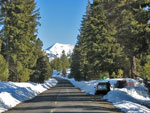
Not Much Parking |
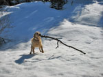
"I've Got A Stick" |
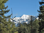
Earl Peak |
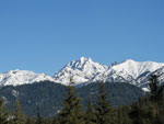
Mt. Stuart |
Teanaway Butte |
Bare Ground |
Logging Landing |
Back To Forest |

Parallel Ridges |
Thinning Forest |
First View Of Lookout |
Help! |
Mt. Rainier |
Break Time |
A Little Closer |
Miller Peak |
Steepest Climb |
Traverse |
On The Ridge Top |
Don't Slip |
Narrow Ridge |
Teanaway Peaks |
On Teanaway Ridge Top |
Lookout Ahead |
Mt. Rainier II |
Photo Page 2
Trips - 2008
Home