5-18-08
The flood of 2003 took out the White Chuck River Road.
It also took out the bridge across the Sauk that accessed the boat launch,
campgrounds, and the White Chuck Bench Trail. Last summer Kim and I biked
up the White Chuck Road bypassing a number of washouts. Then we hiked up
the road and did a three day backpacking trip to Circle Peak and Meadow
Mountain. On those trips we passed the eastern trailhead of the White Chuck
Bench Trail. It was very overgrown and the early part of the trail seemed
to have washed into the river.
It recently came to our attention that access to the western trailhead has been reestablished. The bridge to the boat launch is set to be repaired and access was needed to both sides. Alexi knows the roads in the area and wanted to check out the trail. Kim and I joined him. We met in North Seattle at 6:00 AM. We cruised into Darrington and turned north. Just before the ranger station we turned right on the Sauk Prairie Road. In less than two miles we turned right again on a major dirt road.
This road (Road 24 I believe) is in good shape. It ascends around the east side of Gold Hill. We avoided spur 2411 heading for the summit. We also a major spur turning sharply off to the left. The road is potholed but easily derivable by most cars. After topping out we began to descend. The road continues down to the old Mountain Loop Highway on the east side of the Sauk River. We came to a major road turning off to the left.
Alexi knows these roads well and he did not recognize a road here. It looked to be as well used or better than the one we were on. After a little debate we chose to head left on this road. There are a few trees down but all were cut out. This road actually seems to be two dead end roads that have been connected together. We dropped quickly and lo and behold we came out at the old boat launch. The old Mountain Loop Highway has been closed off with large rocks heading back towards Darrington. As expected there were no other people in the lot.
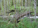
Alexi had done the White Chuck Bench one way ending at the west end. It was eleven years ago. He remembered the trailhead being at the campgrounds. The report we had seen a week earlier showed a photo of the trailhead sign. We immediately found a problem. The road to the campgrounds and the old bridge is no more. It fell into the river. In fact, so did the campgrounds.
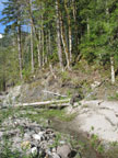
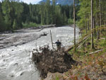
We followed a narrow route along the steep slope to reach some of the old road near the bridge. There is no water going under the bridge. The channel carved away the bridge approach and that is where the water now runs. We found a campgrounds sign but the campgrounds itself fell into the river. Now what to do? We headed up the White Chuck River looking for some tiny piece of the old trail. We soon came to a big washout that took away the whole hillside. We chose to climb up the steep slope alongside the washout.
We climbed up and found... the road we had just driven down. Huh?? We could walk the road above the washout but the map seemed to show the trail down by the river. How what? We chose to descend back down the slope. We continued down from where we had been earlier and found a route to the sandy shore of the river. There were many animal tracks here but no hiker tracks. What about the guy who hiked the trail a week earlier? Now what? We followed the river a little ways then headed inland to the base of the slope.
We were now beyond the washout and the terrain was sandy ground with lots of small alder trees and thickening underbrush. We had no desire to fight our way upstream to the consensus was to head up an even steeper slope to try to find the trail. Up we went using vegetable belays and we climbed up to... a great big bench along the White Chuck. At the lip of the bench was a very obvious trail. It took us one hour to make it to this point which is about 1/4 mile from the real trailhead. Now I'm getting ahead of myself.
Now on trail the going was much easier. There are lots of branches down and 5 years without boots has left the trail overgrown in many places but it's not in all that bad shape. Photo opportunities slowed us down and we did as fair amount of trail maintenance as well. The old trail follows very near the edge of the cliff much of the way. If you lose it stay near the edge and it will reappear. After nearly 1 1/2 hours we reached the 1 km marker. Six tenths of a mile in an hour and a half! Now that's moving!
The grade stayed mostly flat until it began a gentle descent towards the river. We heard the rush of a creek and came to Black Oak Creek. It has a fairly new bridge across and it is in fine shape. The creek may have risen to near bridge deck level in the floods but it survived with no damage. The first part of the trail was in older forest with minimal underbrush. Lower down the brush thickened. We also found more trees down. Some were a pain to get over or under but none proved to be too much of a problem.
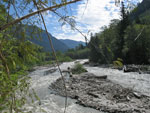
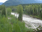
We came to a point right above the river and called it lunch time. We had noticed bugs along the way but they were especially thick here. I was soon ready to get moving again. We were near our turn around time and chose to head a little farther where it looked like we might be able access a big sandy beach along the river. In fact the trail came right to it. A short descent brought us to what was part of the river during the biggest floods. Water was high this weekend with very warm temperatures but this big section was bone dry. We hiked across the sand to the edge of the river.
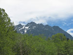
From here we could see up to Meadow Mountain and far down the river. I'm glad we made it far enough to see this spot. Including lunch it took us 3 hours to reach this spot some 2 //2 miles down the trail. We were well short of the mid point of the 6.6 mile trail. In fact we were only about 2 miles from the real trailhead. The trip back was a bit easier as we continued to remove branches from the trail. We passed the point where we first climbed onto the bench and a little farther along the trail seemed to split.
The main route turned right, inland, and a faint path continued along the bluff. We scouted both and neither seemed to go very far. Hmm.... One of them had to work. We chose to take the right path and soon it was buried in a mass of skinny 5 - 8 foot tall fir seedlings. There was still tread but you could not see below your waist. It was not too hard to fight through though we were careful not to fall as we could not see our feet. Within a few hundred feet the trail reappeared and a few minutes later we came out on the road he had driven down.
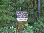
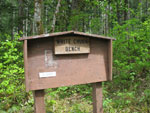
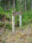
There is a nice big sign for the White Chuck Bench Trail. Another sign shows the distance to the east trailhead. Both signs are pointing downhill. That is the only direction you could drive before the floods. We drove downhill and completely missed the signs. From there we had another half mile of road walking to reach the car.
It was a most interesting day. We messed up at the start and wasted a lot of time but we did succeed in finding the trail and following it a fair distance. There are not a lot of trials that can be hiked all year long. This should be one. The current driving route would be snow covered much of the winter but when the bridge is repaired this trail deserves to be remembered and used. It is not a "view" hike but is a very nice walk in deep dark forest .We saw bleeding hearts, trillium, spring beauty, and a number of other flowers in full bloom. There is also lots of fungus. It was well worth our time and trouble to help bring this trail back into peoples minds and plans once again.
It was fun to continue hiking inaccessible trails in the Darrington area with Kim. It as very nice to finally get out on the trail with Alexi. Hopefully in a few years Sulphur Peak, Circle Peak, Meadow Mountain, and the White Chuck Bench will again be visited by hikers on a regular basis.
Click on thumbnails to get larger pictures.
Trips - 2008
Home
It recently came to our attention that access to the western trailhead has been reestablished. The bridge to the boat launch is set to be repaired and access was needed to both sides. Alexi knows the roads in the area and wanted to check out the trail. Kim and I joined him. We met in North Seattle at 6:00 AM. We cruised into Darrington and turned north. Just before the ranger station we turned right on the Sauk Prairie Road. In less than two miles we turned right again on a major dirt road.
This road (Road 24 I believe) is in good shape. It ascends around the east side of Gold Hill. We avoided spur 2411 heading for the summit. We also a major spur turning sharply off to the left. The road is potholed but easily derivable by most cars. After topping out we began to descend. The road continues down to the old Mountain Loop Highway on the east side of the Sauk River. We came to a major road turning off to the left.
Alexi knows these roads well and he did not recognize a road here. It looked to be as well used or better than the one we were on. After a little debate we chose to head left on this road. There are a few trees down but all were cut out. This road actually seems to be two dead end roads that have been connected together. We dropped quickly and lo and behold we came out at the old boat launch. The old Mountain Loop Highway has been closed off with large rocks heading back towards Darrington. As expected there were no other people in the lot.
Alexi had done the White Chuck Bench one way ending at the west end. It was eleven years ago. He remembered the trailhead being at the campgrounds. The report we had seen a week earlier showed a photo of the trailhead sign. We immediately found a problem. The road to the campgrounds and the old bridge is no more. It fell into the river. In fact, so did the campgrounds.
We followed a narrow route along the steep slope to reach some of the old road near the bridge. There is no water going under the bridge. The channel carved away the bridge approach and that is where the water now runs. We found a campgrounds sign but the campgrounds itself fell into the river. Now what to do? We headed up the White Chuck River looking for some tiny piece of the old trail. We soon came to a big washout that took away the whole hillside. We chose to climb up the steep slope alongside the washout.
We climbed up and found... the road we had just driven down. Huh?? We could walk the road above the washout but the map seemed to show the trail down by the river. How what? We chose to descend back down the slope. We continued down from where we had been earlier and found a route to the sandy shore of the river. There were many animal tracks here but no hiker tracks. What about the guy who hiked the trail a week earlier? Now what? We followed the river a little ways then headed inland to the base of the slope.
We were now beyond the washout and the terrain was sandy ground with lots of small alder trees and thickening underbrush. We had no desire to fight our way upstream to the consensus was to head up an even steeper slope to try to find the trail. Up we went using vegetable belays and we climbed up to... a great big bench along the White Chuck. At the lip of the bench was a very obvious trail. It took us one hour to make it to this point which is about 1/4 mile from the real trailhead. Now I'm getting ahead of myself.
Now on trail the going was much easier. There are lots of branches down and 5 years without boots has left the trail overgrown in many places but it's not in all that bad shape. Photo opportunities slowed us down and we did as fair amount of trail maintenance as well. The old trail follows very near the edge of the cliff much of the way. If you lose it stay near the edge and it will reappear. After nearly 1 1/2 hours we reached the 1 km marker. Six tenths of a mile in an hour and a half! Now that's moving!
The grade stayed mostly flat until it began a gentle descent towards the river. We heard the rush of a creek and came to Black Oak Creek. It has a fairly new bridge across and it is in fine shape. The creek may have risen to near bridge deck level in the floods but it survived with no damage. The first part of the trail was in older forest with minimal underbrush. Lower down the brush thickened. We also found more trees down. Some were a pain to get over or under but none proved to be too much of a problem.
We came to a point right above the river and called it lunch time. We had noticed bugs along the way but they were especially thick here. I was soon ready to get moving again. We were near our turn around time and chose to head a little farther where it looked like we might be able access a big sandy beach along the river. In fact the trail came right to it. A short descent brought us to what was part of the river during the biggest floods. Water was high this weekend with very warm temperatures but this big section was bone dry. We hiked across the sand to the edge of the river.
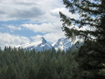
From here we could see up to Meadow Mountain and far down the river. I'm glad we made it far enough to see this spot. Including lunch it took us 3 hours to reach this spot some 2 //2 miles down the trail. We were well short of the mid point of the 6.6 mile trail. In fact we were only about 2 miles from the real trailhead. The trip back was a bit easier as we continued to remove branches from the trail. We passed the point where we first climbed onto the bench and a little farther along the trail seemed to split.
The main route turned right, inland, and a faint path continued along the bluff. We scouted both and neither seemed to go very far. Hmm.... One of them had to work. We chose to take the right path and soon it was buried in a mass of skinny 5 - 8 foot tall fir seedlings. There was still tread but you could not see below your waist. It was not too hard to fight through though we were careful not to fall as we could not see our feet. Within a few hundred feet the trail reappeared and a few minutes later we came out on the road he had driven down.
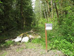
There is a nice big sign for the White Chuck Bench Trail. Another sign shows the distance to the east trailhead. Both signs are pointing downhill. That is the only direction you could drive before the floods. We drove downhill and completely missed the signs. From there we had another half mile of road walking to reach the car.
It was a most interesting day. We messed up at the start and wasted a lot of time but we did succeed in finding the trail and following it a fair distance. There are not a lot of trials that can be hiked all year long. This should be one. The current driving route would be snow covered much of the winter but when the bridge is repaired this trail deserves to be remembered and used. It is not a "view" hike but is a very nice walk in deep dark forest .We saw bleeding hearts, trillium, spring beauty, and a number of other flowers in full bloom. There is also lots of fungus. It was well worth our time and trouble to help bring this trail back into peoples minds and plans once again.
It was fun to continue hiking inaccessible trails in the Darrington area with Kim. It as very nice to finally get out on the trail with Alexi. Hopefully in a few years Sulphur Peak, Circle Peak, Meadow Mountain, and the White Chuck Bench will again be visited by hikers on a regular basis.
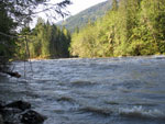
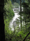
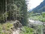
Sauk River |
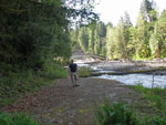
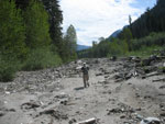
End Of The Road |
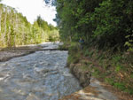
What Road? |
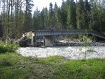
Broken Bridge |
Campgrounds Sign |
Route To River |
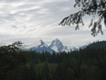
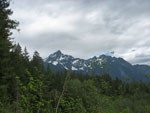
Bedal & Sloan Peaks |
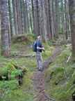
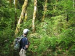
Alixi On Trail |
River Below |
A Little Overgrown |
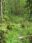
The Trail Is There |
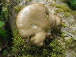
Mushroom |
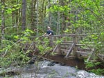
Bridge is Intact |
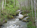
Black Oak Creek |
Lunch Spot |
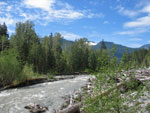
Towards Meadow Mt. |
Almost Took Out Trail |
Dry Channel |
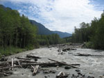
Up River |
Turn Around Point |
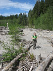
Kim In The River Bed |
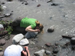
Cooling Off |
Mountain View |
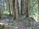
Back On Trail |
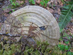
Fungus |
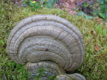
Another Fungus |
Black Oak Bridge |
Trailhead Sign |
Mileage Sign |
More Mountains |
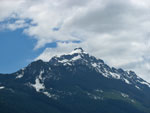
Mt. Pugh |
Where We Were |
Bedal & Sloan Again |
Old MLH |
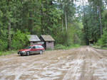
Boat Launch Lot |
Trips - 2008
Home