Page 2
Day Two
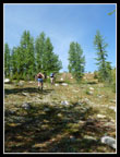
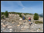
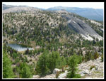
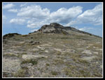
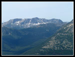
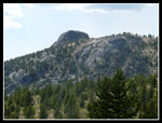
We planned to head west to scramble up Haig and the high point of Bauerman Ridge. Janet was on her first backpacking trip since knee surgeries and was planning to stay off the steep slopes. We all headed out together early under blue skies and a rising temperature. The trail drops into the burn beyond Louden Lake. Suzanne and I did the peak to the north in 2007 which we named Sadie's Peak. We made very fast time and stopped at a creek under the summit of Haig to pump water. We had hiked about four miles in one hour and ten minutes. Soon we headed up easy an easy slope on grass with some trees. The grade flattened on the ridge top. Views were outstanding.
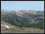
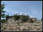
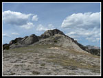
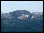
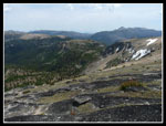
One more short climb took us to the upper ridge and small summit block. Most of the summits in this area are huge. Armstong seems to be a mile across. Others are little rocky points on big broad flats. With 4 1/2 miles in the books we looked over to Bauerman Ridge. From Haig the broad ridge descends gently before a steeper drop to a saddle. I steep climb goes to the top of Teapot Dome. Another drop to a small tarn on the map in a saddle then a climb up Bauerman and a longer ridge walk past a few bumps to the high point on the far end. The whole route is rightward curving in a "C" shape.
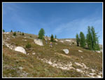
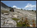
We had very nice views from Haig. Armstong now seemed quite far away, Cathedral Peak not quite so far. Windy Pea was always in sight. Bauerman Ridge seemed to be a long way away. It was still mid morning and we had lots of time. We dropped down from the summit and headed towards Tea Pot Dome. The broad ridge is almost like high desert. Not much grows there. The grade steepened though it was still an easy descent.
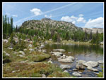
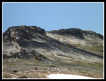
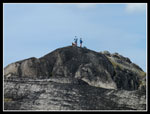
Coming down and looking across the saddle the other side looked awfully steep. At the bottom it looked a little better. Barry led up the slope weaving around big rocks. It turned out to be much easier than it looked. This slope gained 450' in a very short distance. It now felt like it was in the mid 80s and I was really feeling it. I dragged up to the (again) small rock block on top. There I felt a steady breeze we had missed below. It was invigorating. A little food and water and we headed down to the tarn in the saddle before Bauerman Ridge. Turns out it's not a tarn. It's a lake. Much larger than we expected.
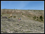
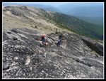
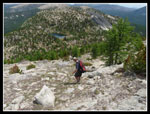
The descent was easy and soon we were at the lake. For simplicity I'll refer to it as Teapot Lake. We were able to easily pump water at the inlet and get ready for the final climb. The slope was part grass and part loose rock. Even that provided good enough footing. As expected Barry, Suzanne, and Gus golden retriever sped ahead and David and I made steady progress. We had seen the side of Bauerman from Haig and it is very steep in places. Once on the ridge top we found it to be plenty wide and easy to travel. No exposure at all.
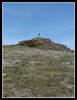
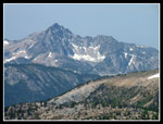
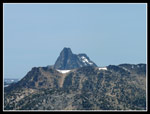
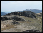
We slogged along past one then another false summit until another came into view. Barry, Suzanne, and Gus were already on top. This one provided a short scramble rather than a walk up. At 8044' it was the highest point I reached this trip. We were only 1000' above camp but we gained three times that getting there. Haig now seemed to be a long way in the distance. Armstong looked tiny. Cathedral Peak was now looking much closer. We could even see the top of Mt. Baker far to the west.
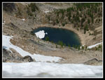
Below us was Sheelite Lake. It still has an iceberg floating in it. Bauerman Ridge keeps most sun off the lake. The wind was blowing hard and cold on the summit. We we able to drop out of the wind and spent about 25 minutes on top. Our plan was to drop back to Teapot Lake then drop down to the Boundary Trail we hiked in on in the morning. We figured a nice easy hike around Haig and back to where we left the trail. That was the theory...
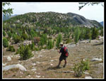
We easily dropped back to the lake. Desscending to the trail was no problem. Then came the hike out. We hiked around a ridge and found the trail went almost to the saddle between Teapot Dome and Haig. Next we hiked out around a longer ridge to pick up where we first left the trail. Except we didn't. It was not the correct ridge. We contoured far in towards Haig then far our aournd another ridge. The trail is in forest here but somehow there wasn't any shade. It was really getting hot. At the crossing to the next ridge we found a running creek and were able to pump even more water. I was badly dehydrated though I had been drinking all day.
Another uphill took us over this ridge and finally to the place we left the ridge. This "easy trail" segment had little shade, lots of ups and down, and added more than a few miles compared to our ridge route in. I was beat but we still had four more miles to go. At least the afternoon clouds began to form and provided a few small bits of shade. David and I pulled into camp running on fumes. Suzanne, Barry, and Gus added Sadie's Summit and another 900' to their day. I'm not much good in high heat and this day proved it. I was very happy to have covered 17 miles with 3600' of gain.
Another evening of bugs and dinner followed by lounging around camp. I finally gave in and broke out the 100% DEET spray. I hate using that stuff but it kept me sane. Actually it worked pretty well. We still had on long sleeves and long pants but my face and hands were not too badly bitten. The hard day was done and we had an easy one planned for tomorrow. Well, at least some of us did.
Click on thumbnails to get larger
pictures.
<< Report &Photo Page >>
Horseshoe Basin Report
Home
We planned to head west to scramble up Haig and the high point of Bauerman Ridge. Janet was on her first backpacking trip since knee surgeries and was planning to stay off the steep slopes. We all headed out together early under blue skies and a rising temperature. The trail drops into the burn beyond Louden Lake. Suzanne and I did the peak to the north in 2007 which we named Sadie's Peak. We made very fast time and stopped at a creek under the summit of Haig to pump water. We had hiked about four miles in one hour and ten minutes. Soon we headed up easy an easy slope on grass with some trees. The grade flattened on the ridge top. Views were outstanding.
One more short climb took us to the upper ridge and small summit block. Most of the summits in this area are huge. Armstong seems to be a mile across. Others are little rocky points on big broad flats. With 4 1/2 miles in the books we looked over to Bauerman Ridge. From Haig the broad ridge descends gently before a steeper drop to a saddle. I steep climb goes to the top of Teapot Dome. Another drop to a small tarn on the map in a saddle then a climb up Bauerman and a longer ridge walk past a few bumps to the high point on the far end. The whole route is rightward curving in a "C" shape.
We had very nice views from Haig. Armstong now seemed quite far away, Cathedral Peak not quite so far. Windy Pea was always in sight. Bauerman Ridge seemed to be a long way away. It was still mid morning and we had lots of time. We dropped down from the summit and headed towards Tea Pot Dome. The broad ridge is almost like high desert. Not much grows there. The grade steepened though it was still an easy descent.
Coming down and looking across the saddle the other side looked awfully steep. At the bottom it looked a little better. Barry led up the slope weaving around big rocks. It turned out to be much easier than it looked. This slope gained 450' in a very short distance. It now felt like it was in the mid 80s and I was really feeling it. I dragged up to the (again) small rock block on top. There I felt a steady breeze we had missed below. It was invigorating. A little food and water and we headed down to the tarn in the saddle before Bauerman Ridge. Turns out it's not a tarn. It's a lake. Much larger than we expected.
The descent was easy and soon we were at the lake. For simplicity I'll refer to it as Teapot Lake. We were able to easily pump water at the inlet and get ready for the final climb. The slope was part grass and part loose rock. Even that provided good enough footing. As expected Barry, Suzanne, and Gus golden retriever sped ahead and David and I made steady progress. We had seen the side of Bauerman from Haig and it is very steep in places. Once on the ridge top we found it to be plenty wide and easy to travel. No exposure at all.
We slogged along past one then another false summit until another came into view. Barry, Suzanne, and Gus were already on top. This one provided a short scramble rather than a walk up. At 8044' it was the highest point I reached this trip. We were only 1000' above camp but we gained three times that getting there. Haig now seemed to be a long way in the distance. Armstong looked tiny. Cathedral Peak was now looking much closer. We could even see the top of Mt. Baker far to the west.
Below us was Sheelite Lake. It still has an iceberg floating in it. Bauerman Ridge keeps most sun off the lake. The wind was blowing hard and cold on the summit. We we able to drop out of the wind and spent about 25 minutes on top. Our plan was to drop back to Teapot Lake then drop down to the Boundary Trail we hiked in on in the morning. We figured a nice easy hike around Haig and back to where we left the trail. That was the theory...
We easily dropped back to the lake. Desscending to the trail was no problem. Then came the hike out. We hiked around a ridge and found the trail went almost to the saddle between Teapot Dome and Haig. Next we hiked out around a longer ridge to pick up where we first left the trail. Except we didn't. It was not the correct ridge. We contoured far in towards Haig then far our aournd another ridge. The trail is in forest here but somehow there wasn't any shade. It was really getting hot. At the crossing to the next ridge we found a running creek and were able to pump even more water. I was badly dehydrated though I had been drinking all day.
Another uphill took us over this ridge and finally to the place we left the ridge. This "easy trail" segment had little shade, lots of ups and down, and added more than a few miles compared to our ridge route in. I was beat but we still had four more miles to go. At least the afternoon clouds began to form and provided a few small bits of shade. David and I pulled into camp running on fumes. Suzanne, Barry, and Gus added Sadie's Summit and another 900' to their day. I'm not much good in high heat and this day proved it. I was very happy to have covered 17 miles with 3600' of gain.
Another evening of bugs and dinner followed by lounging around camp. I finally gave in and broke out the 100% DEET spray. I hate using that stuff but it kept me sane. Actually it worked pretty well. We still had on long sleeves and long pants but my face and hands were not too badly bitten. The hard day was done and we had an easy one planned for tomorrow. Well, at least some of us did.
 Starting Up Haig |
 Near the Ridge Top |
 Final Climb To Haig |
 Summit Of Haig |
 Teapot & Bauerman |
 Peak To West |
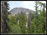
 Rock Formation |
 Haig Ridge |
 About To Descend |
 Teapot Dome Summit |
 Teapot Lake & Bauerman |
 David Looking Down |
 Lake & Dome |
 Bauerman Ridge Above |
 Almost On Top |
 Bumps On Bauerman |
 One More Bump |
 Bauerman High Point |
 On The Summit |
 Cathedral Peak |
 Ampitheater |
 Apex |
 Descending Summit |
 Bauerman Bumps |
 Sheelite Lake |
 Steep Face |
 David Descending |
 Teapot From Trail |
 Formation |
 Back In Camp |
<< Report &Photo Page >>
Horseshoe Basin Report
Home