1-23-10
Back in 1992 I
found an interesting
trip in the book "Footsore 2". A close in low elevation hike where you
can drive to a waterfall and hike to a lake. I must have liked it since
I did the trip three times in one month. I had not been back since. A
few years ago I found out that logging had obliterated some of the
trail. It fell farther off the radar screen. It came back up when Brian
on nwhikers.net hiked some of the trail and did a major clean up of the
lower trail. I was intrigued and joined Brian and some other hikers on
a return clean up trip with an attempt to find the trail to Echo Lake.
I was the only one in the group who had hiked to Echo Lake.
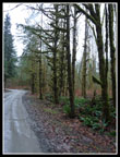
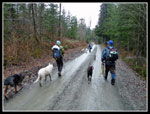
Kathy and I carpooled together from North Seattle. There is no easy direct way to get to the trailhead. We headed towards Granite Falls and took the Machias Road and a few others to get to Lake Roesiger. I recalled a dirt road from the lake to the base of Explorer Falls Things have changed. Now the road is paved and gated just over a mile before the trail start near the falls. We arrived at 9:00 am and Brian was already there. The others would be along soon so we started ahead using the extra time to do some of the clean up work.
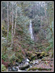
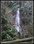
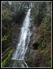
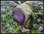
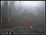
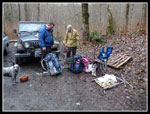
It was easier when I was able to drive the road though it's an easy mile walk. To the right of the road is the Everett watershed and numerous "no trespassing" signs. In short order we reached the unsigned trailhead. The falls can be heard and seen just a short ways off the road. We broke out the garbage sacks as there was a pile of garbage right there. A short walk brought us to near the base of the falls and very nice views. Soon we were heading up the trail. Along the road in is Camp Brinkley, a boy scout camp. The scouts built this trail and do some maintenance. The trail begins with gentle switchbacks that climb to the top of the falls. Next is an easy crossing of Woods Creek. On the other side we quickly found several campsites. These were just piles of trash.
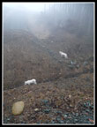
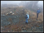
Brian didn't have time to totally clean these up on his previous trip. Chairs, bottles, plastic, and just plain trash. We filled bags and left it to be picked up on the way out. Another series of switchbacks climbs to the ridge top. We took one more detour to another campsite that Brian had cleaned up before. There was very little left to pack out. Part way up the switchbacks we heard barking as the rest of our group caught up. Kent, his daughter Jessica, Joanna, and four more dogs joined us. We reached the ridge, hiked along it a short way, and came to the clear cut.
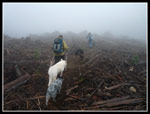
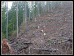
We were hiking in the clouds and visibility was minimal. Even so the cut looked vast. Brian, Kent, and Kathy had been up beyond this point in the last few weeks. A trail has been built through the slash and logs to a logging road. The old trail is not easy to see as it leaves this new route within 75' of the start of the clear cut. It goes left and stays at the far left side of the cut. It has been cleared too. We took the old trail and switchbacked uphill to a flat ridge top. This trail also goes on to the logging road. The old trail turns off left and descends a short way to a creek. Across it is a shelter.
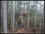
The old trail had a big shelter built by the scouts. It came down in recent years and a new one has replaced it on the same spot. It was already 11:30 and time for a lunch break. After that we headed on via the old trail. An old cut log verified we were on the original trail. Unfortunately, the trail soon ended in more clear cut. Going straight ahead about 1/4 mile would take us to the logging road. Rather than fight slash and downed logs we chose to head back. Across the creek and up the short climb brought us back to the "new" trail. The tall mounds of logging debris and the clouds made for an eerie feel.
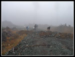
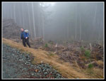
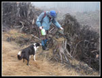
We quickly reached the road and headed left hoping to find where the old trail crossed the road. The road has already been massacred by trenching. Many deep trenches dug in the road with the dirt piled up on both sides. Trails and bridges led around the first ones. Someone has been busy. We came to another road heading off to our right. Kent has been a ways up this one. We chose to keep on the main road looking for the old trail. All the trenches ahead had no bridges. It was a lot of work to climb down and back up each one. Some were more than 20 feet deep. Brian thought he found an old railroad grade heading off left towards the shelter. I had loaded a GPS track from the shelter area straight to the lake and this grade was right on the line. I have never seen an actual map showing the trail so we had to guess the exact location.
On the other side of the road was a more obvious old grade. It was a bit swampy with a number of trees down near the road. I went a short way in and thought this might be the old trail as it was on a railroad grade at this point. We chose to head farther on the road as it was believed the road would switch back and meet the railroad grade father along. The trenches got deeper and more cumbersome to get across. Two members chose to head back to the shelter and the rest of us continued on. In time we came to an intersection. This was a much older road. We chose to turn right towards the lake. Not too much farther along the road came to an end.
Studying satellite photos after the trip it is clear that turning left at the intersection will take you, with a few more turns, to very near Echo Lake. Much longer but it would work. We headed back. At the railroad grade crossing I headed down to take a closer look. After fighting through some downed trees the going became much better. The ponds also went away. There is no doubt in my mind that we were on the old trail to the lake once again. The GPS said we were 1.70 miles away. I will be back this winter to finish the job. Echo Lake is really not all that scenic but I want to finish unraveling the mystery of the disappearing trail. Especially before logging obliterates more of it.
We retraced out steps back to the "new trail". On the way Brian and Kent removed two big heavy filters from big logging machinery. We also found two logging boots sitting on a stump. Our group got back together at the shelter. From there it's all downhill. We stopped to pick up all the garbage we had collected in the morning. I had about 10 lbs. of chairs strapped to my daypack. The road walk was not a great way to finish a hike but it goes by quickly.
I can report that the trail is nearly garbage free now. Much thanks to all who helped. The route to the lake has not been definitively found but I'm almost sure I have it figured out now. As expected, we saw exactly zero people as this is not a heavily used area. It is a nice low elevation winter hiking area. If the old railroad grade does not have many downed trees it may be very hikable without too much difficulty. I saw the falls again after nearly 18 years. I saw the lower trail. I saw a shelter though not the one I remember. I also think the lake is back within reach again. Not a bad way to do some good and have a day of exploration in the Puget Sound lowlands. For the day we hiked just over 8 miles with about 1200' of gain.
The others have posted reports and photos including Brian's GPS track here: Nwhikers Report & Photos
Click on thumbnails to get larger pictures.
Trips - 2010
Home
Kathy and I carpooled together from North Seattle. There is no easy direct way to get to the trailhead. We headed towards Granite Falls and took the Machias Road and a few others to get to Lake Roesiger. I recalled a dirt road from the lake to the base of Explorer Falls Things have changed. Now the road is paved and gated just over a mile before the trail start near the falls. We arrived at 9:00 am and Brian was already there. The others would be along soon so we started ahead using the extra time to do some of the clean up work.
It was easier when I was able to drive the road though it's an easy mile walk. To the right of the road is the Everett watershed and numerous "no trespassing" signs. In short order we reached the unsigned trailhead. The falls can be heard and seen just a short ways off the road. We broke out the garbage sacks as there was a pile of garbage right there. A short walk brought us to near the base of the falls and very nice views. Soon we were heading up the trail. Along the road in is Camp Brinkley, a boy scout camp. The scouts built this trail and do some maintenance. The trail begins with gentle switchbacks that climb to the top of the falls. Next is an easy crossing of Woods Creek. On the other side we quickly found several campsites. These were just piles of trash.
Brian didn't have time to totally clean these up on his previous trip. Chairs, bottles, plastic, and just plain trash. We filled bags and left it to be picked up on the way out. Another series of switchbacks climbs to the ridge top. We took one more detour to another campsite that Brian had cleaned up before. There was very little left to pack out. Part way up the switchbacks we heard barking as the rest of our group caught up. Kent, his daughter Jessica, Joanna, and four more dogs joined us. We reached the ridge, hiked along it a short way, and came to the clear cut.
We were hiking in the clouds and visibility was minimal. Even so the cut looked vast. Brian, Kent, and Kathy had been up beyond this point in the last few weeks. A trail has been built through the slash and logs to a logging road. The old trail is not easy to see as it leaves this new route within 75' of the start of the clear cut. It goes left and stays at the far left side of the cut. It has been cleared too. We took the old trail and switchbacked uphill to a flat ridge top. This trail also goes on to the logging road. The old trail turns off left and descends a short way to a creek. Across it is a shelter.
The old trail had a big shelter built by the scouts. It came down in recent years and a new one has replaced it on the same spot. It was already 11:30 and time for a lunch break. After that we headed on via the old trail. An old cut log verified we were on the original trail. Unfortunately, the trail soon ended in more clear cut. Going straight ahead about 1/4 mile would take us to the logging road. Rather than fight slash and downed logs we chose to head back. Across the creek and up the short climb brought us back to the "new" trail. The tall mounds of logging debris and the clouds made for an eerie feel.
We quickly reached the road and headed left hoping to find where the old trail crossed the road. The road has already been massacred by trenching. Many deep trenches dug in the road with the dirt piled up on both sides. Trails and bridges led around the first ones. Someone has been busy. We came to another road heading off to our right. Kent has been a ways up this one. We chose to keep on the main road looking for the old trail. All the trenches ahead had no bridges. It was a lot of work to climb down and back up each one. Some were more than 20 feet deep. Brian thought he found an old railroad grade heading off left towards the shelter. I had loaded a GPS track from the shelter area straight to the lake and this grade was right on the line. I have never seen an actual map showing the trail so we had to guess the exact location.
On the other side of the road was a more obvious old grade. It was a bit swampy with a number of trees down near the road. I went a short way in and thought this might be the old trail as it was on a railroad grade at this point. We chose to head farther on the road as it was believed the road would switch back and meet the railroad grade father along. The trenches got deeper and more cumbersome to get across. Two members chose to head back to the shelter and the rest of us continued on. In time we came to an intersection. This was a much older road. We chose to turn right towards the lake. Not too much farther along the road came to an end.
Studying satellite photos after the trip it is clear that turning left at the intersection will take you, with a few more turns, to very near Echo Lake. Much longer but it would work. We headed back. At the railroad grade crossing I headed down to take a closer look. After fighting through some downed trees the going became much better. The ponds also went away. There is no doubt in my mind that we were on the old trail to the lake once again. The GPS said we were 1.70 miles away. I will be back this winter to finish the job. Echo Lake is really not all that scenic but I want to finish unraveling the mystery of the disappearing trail. Especially before logging obliterates more of it.
We retraced out steps back to the "new trail". On the way Brian and Kent removed two big heavy filters from big logging machinery. We also found two logging boots sitting on a stump. Our group got back together at the shelter. From there it's all downhill. We stopped to pick up all the garbage we had collected in the morning. I had about 10 lbs. of chairs strapped to my daypack. The road walk was not a great way to finish a hike but it goes by quickly.
I can report that the trail is nearly garbage free now. Much thanks to all who helped. The route to the lake has not been definitively found but I'm almost sure I have it figured out now. As expected, we saw exactly zero people as this is not a heavily used area. It is a nice low elevation winter hiking area. If the old railroad grade does not have many downed trees it may be very hikable without too much difficulty. I saw the falls again after nearly 18 years. I saw the lower trail. I saw a shelter though not the one I remember. I also think the lake is back within reach again. Not a bad way to do some good and have a day of exploration in the Puget Sound lowlands. For the day we hiked just over 8 miles with about 1200' of gain.
The others have posted reports and photos including Brian's GPS track here: Nwhikers Report & Photos
 Mossy Trees |
 First Look At Falls |
 Closer Look |
 Explorer Falls |
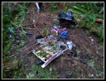 Pile Of Garbage |
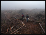 Trail Through Clear Cut |
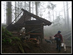 Shelter |
 Group In Shelter |
 Cut Log On Old Trail |
 On The "New Trail" |
 Dogs In Road Trench |
 On The Road Again |
 Avoiding More Trenches |
 The Biggest Trench |
 "Old Trail" In Distance |
 Boots On A Stump |
 Back To The Shelter |
 Goats? |
 Hauling Trash |
 Trash Pile |
Trips - 2010
Home