6-06-10
I often return
to a hike after a 5
or 10 year period. I visited Squak Mountain just a year or two after I
started hiking regularly. That was about 27 years ago. Joey Greene and
I hiked up to Central Peak from Highway 900 the day after Thanksgiving.
We were passed by about 40 two stroke smelly motorcycles. Many of them
were the same folks multiple times. The noise and the smell had me
giving Squak a wide berth while I did a hundred or more hikes on Tiger
and Cougar Mountains. Even when motorcycles were banned I still stayed
away. After such a long time away I decided it was time for a return
visit.
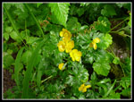
Saturday was sunny and 70 degrees. I couldn't hike. This day was 60 and drizzle most all day. Oh well, getting out is better than staying home. I had a little trouble finding the start but soon had it figured out. A short walk along the highway and I was onto the old road where the West Access Trail begins. There were some flowers right at the gate. The route makes a steady climb gaining about 1500' in 2.3 to Central Peak.
All the junctions are signed, most well. This was my second trip with a new GPS unit and it made navigating pretty easy. All the trails showed up on the GPS. All the creeks were at high water. Most had bridges and the rest were rock hops. I suspect they are dry most of the year. The drizzle was consistent and became a little harder as the day went. on. An umbrella worked just fine as the 60+ degree temperature would have had me stewing in my own juices with a rain jacket on.
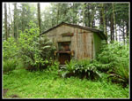
The summit of Central Peak looked different. I wish I had taken a camera on my first visit. From Central Peak I backtracked then took a trail up to the Bullitt Fireplace. I had not visited it before. Hard to imaging a big cabin all alone up there many decades earlier. My route descended to a confusing junction. The trail to West Peak is not signed there. Go 30 on the trail down to May Valley and the spur is signed. The GPS map made this easy to figure out. I climbed over one bump then down to a saddle and one final push up to the top of West Peak.
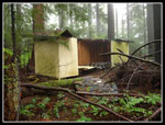
There is a building there though it's in pretty sad shape. My clockwise loop dropped down to the Chybinski Loop Trail. It was a little overgrown in spots and the soaking wet brush quickly left me with soaking wet long pants. I could have put on rain pants but it only took a moment to soak me and then it was too late. A short side trail to the block house is unsigned. I went by before deciding to go back and take a look. There is a whole in the back wall. It was pitch black inside though a flash photo showed the interior. Not much there to get excited about.
I closed the loop and then just had a mile or so back to Highway 900. I passed a family of three just beyond the Bullitt Chimney and nobody else all day. Considering the crowds on Tiger rain or shine I was pleased with the near total solitude right outside Issaquah. I'd say my long overdue return was a success. The trails were all in good condition even with all the rain. There were few folks venturing out on a rainy day. All the intersecting trails make for a number of loop and figure eight possibilities. I will be back for those after work hikes and days when I must be back in the city early. A good time was had, rain not. For the day I hiked 6 miles with 2000' gained.
Click on thumbnails to get larger pictures.
Trips - 2010
Home
Saturday was sunny and 70 degrees. I couldn't hike. This day was 60 and drizzle most all day. Oh well, getting out is better than staying home. I had a little trouble finding the start but soon had it figured out. A short walk along the highway and I was onto the old road where the West Access Trail begins. There were some flowers right at the gate. The route makes a steady climb gaining about 1500' in 2.3 to Central Peak.
All the junctions are signed, most well. This was my second trip with a new GPS unit and it made navigating pretty easy. All the trails showed up on the GPS. All the creeks were at high water. Most had bridges and the rest were rock hops. I suspect they are dry most of the year. The drizzle was consistent and became a little harder as the day went. on. An umbrella worked just fine as the 60+ degree temperature would have had me stewing in my own juices with a rain jacket on.
The summit of Central Peak looked different. I wish I had taken a camera on my first visit. From Central Peak I backtracked then took a trail up to the Bullitt Fireplace. I had not visited it before. Hard to imaging a big cabin all alone up there many decades earlier. My route descended to a confusing junction. The trail to West Peak is not signed there. Go 30 on the trail down to May Valley and the spur is signed. The GPS map made this easy to figure out. I climbed over one bump then down to a saddle and one final push up to the top of West Peak.
There is a building there though it's in pretty sad shape. My clockwise loop dropped down to the Chybinski Loop Trail. It was a little overgrown in spots and the soaking wet brush quickly left me with soaking wet long pants. I could have put on rain pants but it only took a moment to soak me and then it was too late. A short side trail to the block house is unsigned. I went by before deciding to go back and take a look. There is a whole in the back wall. It was pitch black inside though a flash photo showed the interior. Not much there to get excited about.
I closed the loop and then just had a mile or so back to Highway 900. I passed a family of three just beyond the Bullitt Chimney and nobody else all day. Considering the crowds on Tiger rain or shine I was pleased with the near total solitude right outside Issaquah. I'd say my long overdue return was a success. The trails were all in good condition even with all the rain. There were few folks venturing out on a rainy day. All the intersecting trails make for a number of loop and figure eight possibilities. I will be back for those after work hikes and days when I must be back in the city early. A good time was had, rain not. For the day I hiked 6 miles with 2000' gained.
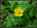 Yellow Flower |
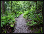 Wet Trail |
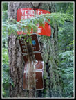 Old Signs |
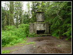 Bullitt Fireplace |
 West Peak |
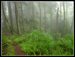 In The Clouds |
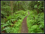 A Thin Brown Line |
 Block House |
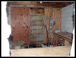 Inside Block House |
 Wet Flowers |
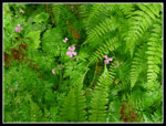 Pink & Green |
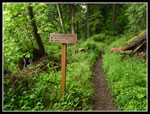 Start Of Trail |
Trips - 2010
Home