6-12-11
Time
for another snow scramble in
the Teanaway area. Janet joined me for a trip up West Esmerelda Peak. I
have done this scramble on dirt in summer and on snow in spring. Snow
is much easier. It does present some additional challenges however. Up
high there was more snow than I have seen before. We met in Bellevue at
6:45 and headed east. Not much traffic as we sailed by Cle Elum then
north on Highway 970 and up the Teanaway Valley. The road is still not
bare to the end with snow the last half mile. Our destination, DeRoux
campground, is about 1 1/2 miles before that. One other car at the
trailhead and another arrived as we were set to leave. That person told
us about a Mountaineer scramble trip up Esmerelda the day before. We
should have tracks to follow in the snow. At 9:05 we were on our way.
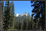
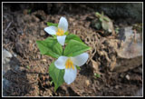
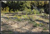
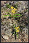
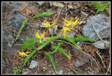
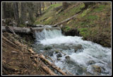
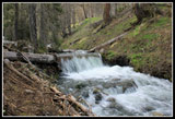
We made it as far as the bridge over the NF Teanaway River when I had to go back to the trailhead. 4/10th of a mile later we were again on our way. It was shorts weather and expected to be warm and sunny later on. Lots of glacier lilies starting in the parking lot. Many trillium also in bloom. Within half a mile there were some snow patches. More snow as we neared the junction with the DeRoux Spur trail. I managed to get onto the wrong trail here. A dozen or more visits and I still messed up in the snow. The GPS quickly showed the error of my ways and we slogged cross country a short way back to the trail. Lots of water on the trail in places and quite a few trees down starting 150' out of the parking lot. We must have climbed over or around a dozen downed trees, some impressively large.
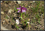
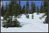
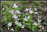
There were still large dirt sections as the route finally began to gain elevation. I have never used a GPS on this trail before and it makes route finding much easier when the trail is under snow. The trail heads north to an open area above the creek. A number of wildflowers in bloom here. Grass widows, violets, glacier lilies, spring beauty among others. With all the snow this was more an early spring flower hike down low and only a cover of white up higher. There were tracks but less than I was expecting with a big Mountaineer group the day before.
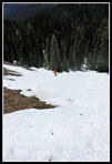
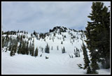
After the route was completely snow covered (about 4300') we found and lost the tracks a number of times. On my previous climb of Esmerelda in early June 2008 we had a tough time near the upper crossing of DeRoux Creek. The route winds around to the north side of the steep ridge just before the crossing. The narrow trail was completely covered with snow. We had to work our way around using brush for hand holds with rotten snow breaking away as we kicked steps. The exposure here may be fatal as you would plummet down to the creek far below. On a trip the year before the other members of the trip had gone straight up and over the ridge we traversed around. I had not tried it but it is a viable option.
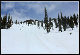
As we neared that dicey spot the previous boot steps headed straight uphill. We decided to follow them up and over rather than checking out the conditions of the traverse. Ice axes came out and we had already put on microspikes. As we climbed steeply the snow became thinner. I left the snow before the other boot prints and climbed up dirt to the ridge top. This was the steepest snow Janet had climbed on her new knees and though she was a little uncomfortable she followed me on up. The way down the other side was just as steep but the snow on the forested northwest side was much deeper. We were able to safely work our way down to the creek.
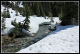
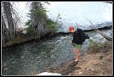
A very steep snow slope separated us from the usual trail crossing. Rather than heading back that way we followed alongside the creek looking for a good log or fording place. No logs but a good ford was found. The far bank was dirt in one place instead of the mostly vertical snowbank. To keep boots dry we crossed barefoot. The water was at least 34 degrees. Boots went back on and we immediately spotted another hiker. It was the guy who arrived as we were getting started. He took the low traverse around the ridge and crossed the creek on a log.
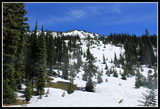
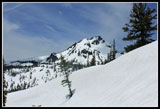
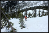
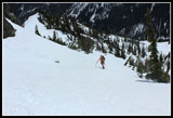
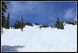
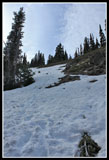
We headed a little farther up the creek and then headed straight uphill. We climbed right in the middle of the summer trail switchbacks. We came out right at the boulder field above the trail. It was already 12:30 and time for lunch. It was getting very warm on the snow. The other guy kept going setting a track up to the basin just above us. We soon caught up. He was done for the day. We continued on up. The route gets quite steep but the footing was good. Open slope gave way to weaving between spaced trees and finally we reached the ridge to our right and followed it. Another basin led to another climb.
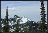
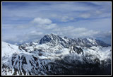
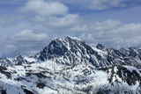
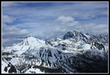
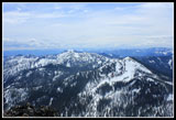
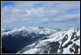
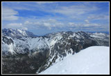
We angled to the right and climbed the final slope to the summits. We picked up steps and a glissade track on the final climb. The hot afternoon sun just about did me in. Some clouds blew in and helped a lot. Near the top we saw another climber traversing above us. He reached the summit first. There was a steady cold wind blowing over the summit. It felt pretty good. Though we could now see more clouds to the north most peaks were in the clear. Fortune was right across to the north and the Stuart Range looked as good as ever. It was 2:30 when we summited. We met Dennis on top. He took a direct route from just after the first bridge crossing. We took the requisite photos and enjoyed the views. By 3:00 pm we headed down.
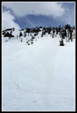
We climbed down to the top of the glissade track. Hard snow with a few inches of afternoon warmed slush on top. I went first. It was faster than I thought it would be. My ice axe was 2/3rds buried to check my speed. Far down the track headed towards a tree. Not a good idea. I self arrested with plenty of space left. Seeing this Janet chose to plunge step down. From the tree we had another good glissade with a gentle run out. We traversed right through trees back to the upper basin. Not steep but we managed a short glissade. Back on the ridge we descended here rather than weave through the trees on the steep slope. Farther down I traversed back onto the open slope for the best glissade of the day. Fast with a flat area at the bottom.
That is where we left the other hiker after lunch. The rest of the way down to the creek was a mix of plunge stepping and glissading. One more cold creek crossing and an easier climb back to the ridge top. The soft thin snow was a pain to downclimb but soon enough we were back on gentle terrain. The rest of the way was just a snow and then dirt slog. At 6:30 we arrived at the lot to find one camper and not hikers. On the drive home it rained on and off most of the way. That made our sunny day all that much sweeter. My two most recent visits to Esmerelda were totally in clouds. This day at least I had some views. All in all, a great day for a snow scramble.
Click on thumbnails to get
larger pictures.
Trips - 2011
Home
We made it as far as the bridge over the NF Teanaway River when I had to go back to the trailhead. 4/10th of a mile later we were again on our way. It was shorts weather and expected to be warm and sunny later on. Lots of glacier lilies starting in the parking lot. Many trillium also in bloom. Within half a mile there were some snow patches. More snow as we neared the junction with the DeRoux Spur trail. I managed to get onto the wrong trail here. A dozen or more visits and I still messed up in the snow. The GPS quickly showed the error of my ways and we slogged cross country a short way back to the trail. Lots of water on the trail in places and quite a few trees down starting 150' out of the parking lot. We must have climbed over or around a dozen downed trees, some impressively large.
There were still large dirt sections as the route finally began to gain elevation. I have never used a GPS on this trail before and it makes route finding much easier when the trail is under snow. The trail heads north to an open area above the creek. A number of wildflowers in bloom here. Grass widows, violets, glacier lilies, spring beauty among others. With all the snow this was more an early spring flower hike down low and only a cover of white up higher. There were tracks but less than I was expecting with a big Mountaineer group the day before.
After the route was completely snow covered (about 4300') we found and lost the tracks a number of times. On my previous climb of Esmerelda in early June 2008 we had a tough time near the upper crossing of DeRoux Creek. The route winds around to the north side of the steep ridge just before the crossing. The narrow trail was completely covered with snow. We had to work our way around using brush for hand holds with rotten snow breaking away as we kicked steps. The exposure here may be fatal as you would plummet down to the creek far below. On a trip the year before the other members of the trip had gone straight up and over the ridge we traversed around. I had not tried it but it is a viable option.
As we neared that dicey spot the previous boot steps headed straight uphill. We decided to follow them up and over rather than checking out the conditions of the traverse. Ice axes came out and we had already put on microspikes. As we climbed steeply the snow became thinner. I left the snow before the other boot prints and climbed up dirt to the ridge top. This was the steepest snow Janet had climbed on her new knees and though she was a little uncomfortable she followed me on up. The way down the other side was just as steep but the snow on the forested northwest side was much deeper. We were able to safely work our way down to the creek.
A very steep snow slope separated us from the usual trail crossing. Rather than heading back that way we followed alongside the creek looking for a good log or fording place. No logs but a good ford was found. The far bank was dirt in one place instead of the mostly vertical snowbank. To keep boots dry we crossed barefoot. The water was at least 34 degrees. Boots went back on and we immediately spotted another hiker. It was the guy who arrived as we were getting started. He took the low traverse around the ridge and crossed the creek on a log.
We headed a little farther up the creek and then headed straight uphill. We climbed right in the middle of the summer trail switchbacks. We came out right at the boulder field above the trail. It was already 12:30 and time for lunch. It was getting very warm on the snow. The other guy kept going setting a track up to the basin just above us. We soon caught up. He was done for the day. We continued on up. The route gets quite steep but the footing was good. Open slope gave way to weaving between spaced trees and finally we reached the ridge to our right and followed it. Another basin led to another climb.
We angled to the right and climbed the final slope to the summits. We picked up steps and a glissade track on the final climb. The hot afternoon sun just about did me in. Some clouds blew in and helped a lot. Near the top we saw another climber traversing above us. He reached the summit first. There was a steady cold wind blowing over the summit. It felt pretty good. Though we could now see more clouds to the north most peaks were in the clear. Fortune was right across to the north and the Stuart Range looked as good as ever. It was 2:30 when we summited. We met Dennis on top. He took a direct route from just after the first bridge crossing. We took the requisite photos and enjoyed the views. By 3:00 pm we headed down.
We climbed down to the top of the glissade track. Hard snow with a few inches of afternoon warmed slush on top. I went first. It was faster than I thought it would be. My ice axe was 2/3rds buried to check my speed. Far down the track headed towards a tree. Not a good idea. I self arrested with plenty of space left. Seeing this Janet chose to plunge step down. From the tree we had another good glissade with a gentle run out. We traversed right through trees back to the upper basin. Not steep but we managed a short glissade. Back on the ridge we descended here rather than weave through the trees on the steep slope. Farther down I traversed back onto the open slope for the best glissade of the day. Fast with a flat area at the bottom.
That is where we left the other hiker after lunch. The rest of the way down to the creek was a mix of plunge stepping and glissading. One more cold creek crossing and an easier climb back to the ridge top. The soft thin snow was a pain to downclimb but soon enough we were back on gentle terrain. The rest of the way was just a snow and then dirt slog. At 6:30 we arrived at the lot to find one camper and not hikers. On the drive home it rained on and off most of the way. That made our sunny day all that much sweeter. My two most recent visits to Esmerelda were totally in clouds. This day at least I had some views. All in all, a great day for a snow scramble.
 Esmerelda Peaks |
 Trillium |
 Grass Widows |
 Glacier Lilies |
 Blooming Glacier Lilies |
 Ascending Detour |
 Creek Crossing Time |
 Looking Towards Summit |
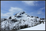
 Hawkins Mountain |
 DeRoux Peak |
 More Uphill |
 Gentler Slope |
 Second Basin |
 Final Slope |
 Almost On Top |
 The Stuart Range |
 Mt. Stuart |
 Fortune Peak |
 Jolly Mountain |
 Harding & The Cradle |
 Teanaway Peaks |
 Heading Down |
 Hawkins Again |
 Last Glissade |
 Last Creek Ford |
 Descending Detour |
 Off Of The Snow |
 Spring Beauty Cluster |
 Slow Motion |
 Fast Motion |
Trips - 2011
Home