8-13-11
I
had only been up the Norse Peak
trail 2 or 3 times in 25 years though I had been to the summit 3 other
times via the winter ridge route. My first visit was on the old trail
and it was shorter and steep. The new trail is very gentle as it makes
many long switchbacks up the mountain. I had a heck of a time settling
on a destination not making the final choice until 7:30 am. I was on
the road at 7:55 heading south. From Enumclaw down Highway 410 to
Crystal Mountain and 4.2 miles up the access road from the highway.
Their is no trailhead parking lot. Cars park right alongside the road.
I was underway at 9:45 am.
The way starts with 2/10ths of a mile of dirt road to the actual trail.
There is a sign but it has no words to identify the Norse Peak trail.
The way starts out at a gentle grade and never changes.
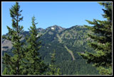
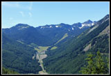
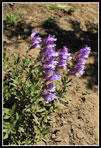
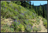
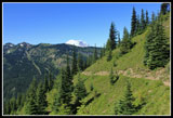
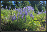
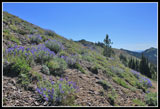
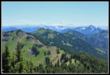
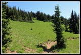
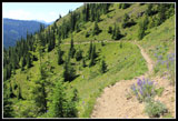
The morning was cool but sunny. As I climbed it quickly warmed up. This is a dry trail. No creek crossings all the way to the summit. I had plenty of water and it never became all that hot. A few ripe strawberries near the start and some wildflower most of the way up. A few open slopes had much more color. The first views out through the trees were of the ridge across the valley and up the valley to the ski area. The lot was already filling up. Since I had all day there was no real hurry. I took lots of photo breaks. Many times I came to bits of the old trail. Some had "trail closed" signs. Most of the junctions had no signs. Taking the gently graded uphill trail was always the correct choice.
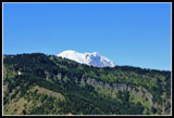
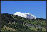
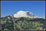
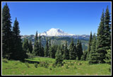
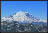
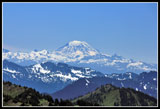
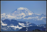
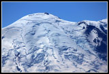
At one open switchback I noticed that the big white top of Mt. Rainier came into view. Not a cloud in the sky. The ice cream cone like summit was crystal clear. Lots of tiger lilies for about the 4th week in a row. They seem to be blooming everywhere right now. The trail goes from open slopes to forest numerous times. A few minutes of views then back into the cool forest. The trail has not been logged out yet this year though none of the half dozen plus logs down presented a problem. I did manage to drag one off the trail. It had been so long since I had been up the trail that I remembered almost none of it. Near the ridge top the route switchbacked up some larger green meadows. I saw exactly one beargrass here, the only one of the day.
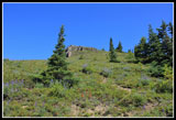
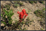
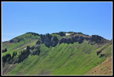
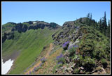
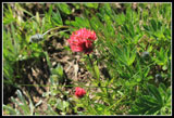
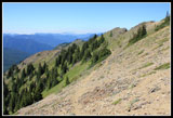
The trail reached the ridge top and followed it a short way. It reached a junction with a trail dropping down the back side. Just after the route traversed below the ridge on the left side. A short steep climb brought me back to the ridge top and now onto the right side. The next section is the sketchiest part of the hike. The route is narrow on the steep hillside as it also has some loose rock here. Not really dangerous but a little unnerving if you only hike wide smooth trails. That is quickly\y passed and the route aims for the summit which is finally in sight. The trail winds around the left side before climbing up the summit. Along here I saw the only magenta Indian paintbrush of the day.
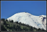
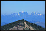
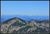
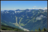
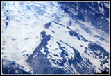
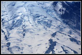
I arrived at the summit at 12:20. 5 miles in 2 hours and 35 minutes. Not too bad considering all the stops for photos and just to enjoy the views. There were three hikers on the summit. They were enjoying a little wine. When offered I accepted a glass. Not what I usually find on a summit. Those folks had a great time coming up and were soon to be heading back down. Great summit views. Mt. Adams was especially clear. Still a lot of white on the north side. There were clouds to the west and north with Mt. Baker hidden in white. Glacier Peak did peak out from behind the Cascade crest peaks just north of Snoqualmie Pass.
The other soon left and I had a brief time alone before a group of 12 arrived. I like meeting other hikers but 12 was just a little too much so I moved down the slope a ways. Warm at the summit with a little cool breeze made for near perfect conditions. I had no bug problems coming up but they were present on the summit. The wind kept them mostly at bay. I spent 1:45 on top, outlasting the big group and allowing me to go back to the summit. At 2:00 pm I headed down. The hike down was very easy. The old 4 mile trail was lengthened to 5 miles and is the same gentle grade most all the way. I met a couple of groups coming up and mysteriously I could hear voices behind me though I never saw the hikers. They must have come up a different route. They came out just a few minutes behind me.
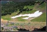
With only about a half mile to go I met a large group of horse riders. I had to climb down the steep slope to let them by. I think there were 8-10 horses in the group. I reached my car at about 4:00 pm. This was a very nice hike. Other than the one summit group I saw very few folks. The temperature was perfect. Bugs were not a problem. The summit views are outstanding. Wildflowers were not spectacular but good along much of the way. There was no snow on the trail. On a summer day like this the trail should have been packed. After two winter trips and a long period since my last summer visit it was nice to do this hike on a warm dry day.
Click on thumbnails to get
larger pictures.
Trips - 2011
Home
The morning was cool but sunny. As I climbed it quickly warmed up. This is a dry trail. No creek crossings all the way to the summit. I had plenty of water and it never became all that hot. A few ripe strawberries near the start and some wildflower most of the way up. A few open slopes had much more color. The first views out through the trees were of the ridge across the valley and up the valley to the ski area. The lot was already filling up. Since I had all day there was no real hurry. I took lots of photo breaks. Many times I came to bits of the old trail. Some had "trail closed" signs. Most of the junctions had no signs. Taking the gently graded uphill trail was always the correct choice.
At one open switchback I noticed that the big white top of Mt. Rainier came into view. Not a cloud in the sky. The ice cream cone like summit was crystal clear. Lots of tiger lilies for about the 4th week in a row. They seem to be blooming everywhere right now. The trail goes from open slopes to forest numerous times. A few minutes of views then back into the cool forest. The trail has not been logged out yet this year though none of the half dozen plus logs down presented a problem. I did manage to drag one off the trail. It had been so long since I had been up the trail that I remembered almost none of it. Near the ridge top the route switchbacked up some larger green meadows. I saw exactly one beargrass here, the only one of the day.
The trail reached the ridge top and followed it a short way. It reached a junction with a trail dropping down the back side. Just after the route traversed below the ridge on the left side. A short steep climb brought me back to the ridge top and now onto the right side. The next section is the sketchiest part of the hike. The route is narrow on the steep hillside as it also has some loose rock here. Not really dangerous but a little unnerving if you only hike wide smooth trails. That is quickly\y passed and the route aims for the summit which is finally in sight. The trail winds around the left side before climbing up the summit. Along here I saw the only magenta Indian paintbrush of the day.
I arrived at the summit at 12:20. 5 miles in 2 hours and 35 minutes. Not too bad considering all the stops for photos and just to enjoy the views. There were three hikers on the summit. They were enjoying a little wine. When offered I accepted a glass. Not what I usually find on a summit. Those folks had a great time coming up and were soon to be heading back down. Great summit views. Mt. Adams was especially clear. Still a lot of white on the north side. There were clouds to the west and north with Mt. Baker hidden in white. Glacier Peak did peak out from behind the Cascade crest peaks just north of Snoqualmie Pass.
The other soon left and I had a brief time alone before a group of 12 arrived. I like meeting other hikers but 12 was just a little too much so I moved down the slope a ways. Warm at the summit with a little cool breeze made for near perfect conditions. I had no bug problems coming up but they were present on the summit. The wind kept them mostly at bay. I spent 1:45 on top, outlasting the big group and allowing me to go back to the summit. At 2:00 pm I headed down. The hike down was very easy. The old 4 mile trail was lengthened to 5 miles and is the same gentle grade most all the way. I met a couple of groups coming up and mysteriously I could hear voices behind me though I never saw the hikers. They must have come up a different route. They came out just a few minutes behind me.
With only about a half mile to go I met a large group of horse riders. I had to climb down the steep slope to let them by. I think there were 8-10 horses in the group. I reached my car at about 4:00 pm. This was a very nice hike. Other than the one summit group I saw very few folks. The temperature was perfect. Bugs were not a problem. The summit views are outstanding. Wildflowers were not spectacular but good along much of the way. There was no snow on the trail. On a summer day like this the trail should have been packed. After two winter trips and a long period since my last summer visit it was nice to do this hike on a warm dry day.
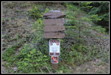 Trailhead Non Sign |
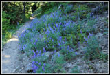 Lupine |
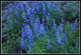 Lupine Close Up |
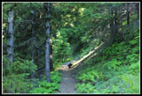 Hiking Grouse |
 Lit Up Paintbrush |
 First View Out |
 Crystal Mt. Ski Area |
 Penstemon |
 Rainier Peaks Over Ridge |
 Closer Look |
 Even Closer |
 Open Grassy Slope |
 Flower Lined Trail |
 Bright Paintbrush |
 Trail & Rainier |
 Bright Lupine |
 More Of The Mountain |
 Rainier Over Meadow |
 Ridge To The North |
 Flowers On Ridge Top |
 Tranversing To Summit |
 Magenta Paintbrush |
 Glacier Peak |
 Cascade Crest Peaks |
 Mt. Rainier From Summit |
 Mt. Adams |
 Meadering Ridge |
 Ski Area |
 Steamboat Prow |
 Adams Close Up |
 Emmons Glacier |
 Upper Emmons |
 Sketchy Trail |
 Only Snow Seen |
 Meadow |
 Gently Graded Trail |
Trips - 2011
Home