01-09-11
Choosing
a destination was difficult as the snow level approached sea level.
There were supposed to be some snow showers in the morning then
clearing in the afternoon. I chose to stay out of the Cascades and head
north to Blanchard Mountain. Before leaving I saw an area of snow
showers south of Mt. Vernon but the highway cameras in Mt. Vernon
showed bare roads. Heck, a little snow would not be problem. I left
Seattle just after 8:00 am. The road was clear until south of Mt.
Vernon where slush was on the freeway. Traffic slowed down and there
were a couple cars that had spun off the road. Nearer to Mt. Vernon the
slush grew deeper. A whole lot deeper.
Soon the whole road was covered in compact snow and the big flakes coming down were more like a blizzard. Traffic slowed to about 30 mph and visibility was minimal. Not what I was expecting. I thought about turning around but the unplowed exits looked pretty bad. I clung to the fact that an hour earlier cameras showed no snow to here or to the north. Somewhere just north of Highway 20 the snow stopped. Then the road was bare again. Back to 70 mph. There was no snow to be seen until a mile before the Alger exit. At the exit the ground was covered in white.
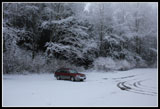
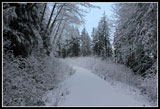
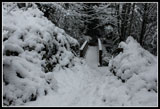
I turned left then left again soon on Barrell Springs Road. The road was covered in several inches of wet slush. A right turn on the gravel road to the trailhead proved to be much less of a problem than expected. The road was covered in snow but it was only a few inches deep. I made it up the one steep hill fine and continued on to the Upper Trailhead. There were tracks but no cars in the lot. It was 9:45 when I got started. I chose to make a counter clockwise loop this time.
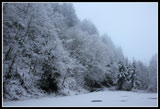
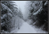
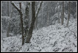
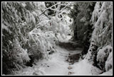
I started up the road passing the gate almost immediately. The small deciduous trees lining the road were weighed down with inches of fresh snow. It was nice to hike with no bootprints in the snow. Animal tracks were all I saw. The gray sky began to lighten. I held out hope for some good views from Oyster Dome. On the other hand, if that blizzard kept moving north it might get awfully white awfully fast.
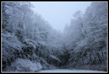
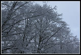
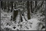
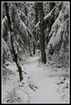
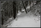
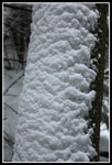
I turned left onto the Alternate Incline Trail. Before leaving the road the snow depth grew from a couple inches at my car to 4 or 5 inches. In the trees it was a little thinner though almost no ground was bare. The snow covered trail was not too hard to follow. The very heavily flocked trees, ferns, stumps, etc. were very pretty. I took my heavier DSLR on this trip and spent a lot of time shooting the snowy scenery.
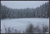
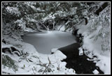
I had no trouble finding both ends of the old Incline Trail by the bright red and white "This Is Not A Trail" signs. After merging with the upper end the route becomes much more gentle. I wove through the forest to the junction with the Pacific Northwest Trail (PNT). I turned right a short way to Lizard Lake. I visited in early February last year and skunk cabbage was already blooming. That "non winter" looked nothing like this winter. The lake was covered in white though there was a little open water at the shore.
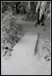
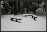
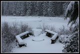
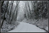
The tables and the fire pit were buried in snow. My visit was short. In a few minutes I was back at the junction. The PNT follows an old grade so the route is pretty flat over to Lily Lake. A few snowflakes were beginning to fall. The sky was a uniform dark gray again. I was not hopeful for any views. I reached the Lily Lake Trail which would be my return route. It reaches the road just below the parking lot. There were no tracks on that trail.
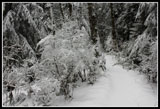
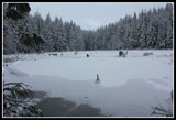
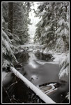
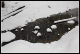
Next I reached the side trail to Lily Lake and turned right on it. A very short walk brought me to the lake. The lake was completely white. Snow covered everything including the water. It was 11:30 am when I reached the lake. I returned to the junction and headed on towards Oyster Dome. The route descends gentle soon crossing the Lily Lake outlet creek. More water here than I have ever seen. The route turns to the right and with a few ups and downs reaches the junction with the main Oyster Dome trail that comes up from Chuckanut Drive. After seeing no boot prints all day it now looked like and army had come through.
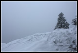
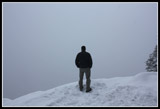
One more wider than normal creek crossing and it was all uphill. I reached the Oyster Dome overlook to find two people there. The view was non existent. White snow merged into gray sky. I couldn't even see the trees right below. The flocked trees at the overlook did look good though. Snow was falling steadily now. I had my lunch and enjoyed the company. We had a true Trail Pair summit view. Twenty minutes later I was ready to leave. I took a short side trip to the summit of the dome but as expected even close by North Butte was lost in the clouds.
It did not take long to reach the junction with the trail to Lily Lake. No bootprints while I was gone. The trail back to the lake had a few open spots and I could see the snow was coming down much harder now. When I reached Max's Shortcut there suddenly were many footprints. They were all heading down that trail. It was not far to the Lily Lake junction with the PNT. There were just a few bootprints heading downhill. I saw two other tracks. A close look showed it wasn't ski tracks. It was from two bicycles. From 2-5 inches of soft snow and folks were biking?
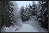
The downhill went pretty well. The only bad part was the snow and temperature. Snow stuck to the bottom of my gaiters. Every dozen steps I had to try to grind off several inches of hard packed icy snow. The trail was built to be easy for horses and bikes and it takes some 2 1/2 miles to lose 1200'. At less than a 10% grade it seems to wind all over the mountain. Near the trail that goes over to Max's Shortcut I met two bikers coming up. They were having fun despite the conditions. Towards the bottom the snow thinned out considerably. There was even a little bare ground.
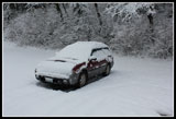
When I reached the road I found that the tire tracks I followed in the morning were now completely snow covered. Back at my car I found a group of trail runners who were just getting started. My car had about 4 inches of snow covering it. I arrived back at the start at 2:15. The 8 mile loop took 4 1/2 hours. The road was slick coming down. Barrell Springs Road was even slushier than in the morning. The freeway was bare all the way home. There was no indication of the compact snow seen in the morning. I even made it home before dark. This is a great winter hike. Even better when it has a fresh coating of snow. In another three months the wildflowers and skunk cabbage will be out. For now it is winter on Blanchard Hill.
Click on thumbnails to get
larger pictures.
Trips - 2011
Home
Soon the whole road was covered in compact snow and the big flakes coming down were more like a blizzard. Traffic slowed to about 30 mph and visibility was minimal. Not what I was expecting. I thought about turning around but the unplowed exits looked pretty bad. I clung to the fact that an hour earlier cameras showed no snow to here or to the north. Somewhere just north of Highway 20 the snow stopped. Then the road was bare again. Back to 70 mph. There was no snow to be seen until a mile before the Alger exit. At the exit the ground was covered in white.
I turned left then left again soon on Barrell Springs Road. The road was covered in several inches of wet slush. A right turn on the gravel road to the trailhead proved to be much less of a problem than expected. The road was covered in snow but it was only a few inches deep. I made it up the one steep hill fine and continued on to the Upper Trailhead. There were tracks but no cars in the lot. It was 9:45 when I got started. I chose to make a counter clockwise loop this time.
I started up the road passing the gate almost immediately. The small deciduous trees lining the road were weighed down with inches of fresh snow. It was nice to hike with no bootprints in the snow. Animal tracks were all I saw. The gray sky began to lighten. I held out hope for some good views from Oyster Dome. On the other hand, if that blizzard kept moving north it might get awfully white awfully fast.
I turned left onto the Alternate Incline Trail. Before leaving the road the snow depth grew from a couple inches at my car to 4 or 5 inches. In the trees it was a little thinner though almost no ground was bare. The snow covered trail was not too hard to follow. The very heavily flocked trees, ferns, stumps, etc. were very pretty. I took my heavier DSLR on this trip and spent a lot of time shooting the snowy scenery.
I had no trouble finding both ends of the old Incline Trail by the bright red and white "This Is Not A Trail" signs. After merging with the upper end the route becomes much more gentle. I wove through the forest to the junction with the Pacific Northwest Trail (PNT). I turned right a short way to Lizard Lake. I visited in early February last year and skunk cabbage was already blooming. That "non winter" looked nothing like this winter. The lake was covered in white though there was a little open water at the shore.
The tables and the fire pit were buried in snow. My visit was short. In a few minutes I was back at the junction. The PNT follows an old grade so the route is pretty flat over to Lily Lake. A few snowflakes were beginning to fall. The sky was a uniform dark gray again. I was not hopeful for any views. I reached the Lily Lake Trail which would be my return route. It reaches the road just below the parking lot. There were no tracks on that trail.
Next I reached the side trail to Lily Lake and turned right on it. A very short walk brought me to the lake. The lake was completely white. Snow covered everything including the water. It was 11:30 am when I reached the lake. I returned to the junction and headed on towards Oyster Dome. The route descends gentle soon crossing the Lily Lake outlet creek. More water here than I have ever seen. The route turns to the right and with a few ups and downs reaches the junction with the main Oyster Dome trail that comes up from Chuckanut Drive. After seeing no boot prints all day it now looked like and army had come through.
One more wider than normal creek crossing and it was all uphill. I reached the Oyster Dome overlook to find two people there. The view was non existent. White snow merged into gray sky. I couldn't even see the trees right below. The flocked trees at the overlook did look good though. Snow was falling steadily now. I had my lunch and enjoyed the company. We had a true Trail Pair summit view. Twenty minutes later I was ready to leave. I took a short side trip to the summit of the dome but as expected even close by North Butte was lost in the clouds.
It did not take long to reach the junction with the trail to Lily Lake. No bootprints while I was gone. The trail back to the lake had a few open spots and I could see the snow was coming down much harder now. When I reached Max's Shortcut there suddenly were many footprints. They were all heading down that trail. It was not far to the Lily Lake junction with the PNT. There were just a few bootprints heading downhill. I saw two other tracks. A close look showed it wasn't ski tracks. It was from two bicycles. From 2-5 inches of soft snow and folks were biking?
The downhill went pretty well. The only bad part was the snow and temperature. Snow stuck to the bottom of my gaiters. Every dozen steps I had to try to grind off several inches of hard packed icy snow. The trail was built to be easy for horses and bikes and it takes some 2 1/2 miles to lose 1200'. At less than a 10% grade it seems to wind all over the mountain. Near the trail that goes over to Max's Shortcut I met two bikers coming up. They were having fun despite the conditions. Towards the bottom the snow thinned out considerably. There was even a little bare ground.
When I reached the road I found that the tire tracks I followed in the morning were now completely snow covered. Back at my car I found a group of trail runners who were just getting started. My car had about 4 inches of snow covering it. I arrived back at the start at 2:15. The 8 mile loop took 4 1/2 hours. The road was slick coming down. Barrell Springs Road was even slushier than in the morning. The freeway was bare all the way home. There was no indication of the compact snow seen in the morning. I even made it home before dark. This is a great winter hike. Even better when it has a fresh coating of snow. In another three months the wildflowers and skunk cabbage will be out. For now it is winter on Blanchard Hill.
 Upper Trailhead |
 Trees Form Roof |
 Lone Car In Lot |
 Starting Up Road |
 New Trees Narrow Road |
 Only Bluish Sky Of Day |
 Flocked Trees Overhead |
 Stump Along Trail |
 Snowy Trail |
 White Foliage |
 Bridge At Lizard Lake |
 Lizard Lake |
 Lizard Lake Camp |
 On The PNT |
 Lily Outlet |
 Lily Lake Viewpoint |
 Lily Lake |
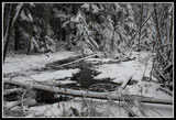 Snowy Outlet Creek |
 Oyster Dome View |
 Hiker At OD Cliff Edge |
 Heavy Snowfall |
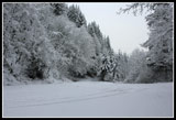
 Freeze On Creek |
 Snow Patterns |
 More Heavy Snowfall |
 A Little Bare Trail |
 Last Bridge |
 Back On The Road |
 5" Of New Snow |
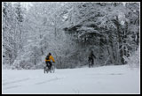 Crazy Bikers |
 Last Flocked View |
Trips - 2011
Home