8-06-11
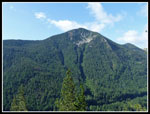
Rock Mountain via the trail up
from Highway 2 is an early summer favorite of mine. The switchbacking
climb up the south facing slope melts out early then the upper part is
partly to mostly on snow to the summit. As much as I like it, it had
been 9 years since my last trip up this trail. Janet joined me for this
trip. We met in Monroe at 7:30 am and drove across Stevens Pass to the
small parking lot under powerlines. One other car there as we got
started at 8:50 am. The route begins on the road up to the powerline
towers. A couple of switchbacks and road is left for trail. The trail
is narrow but in pretty good condition. Flowers began almost at once.
Scarlet gilia is still holding on but probably not for much longer.
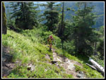
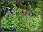
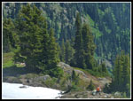
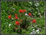
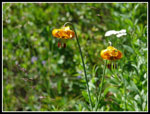
The trail is easy to describe. Many short switchbacks. It is not all that steep but it climbs relentlessly. Forest gives way to open slopes and more forest. It would be awfully hot in mid afternoon heading up but was not too bad with our early start. We had overcast and even a little drizzle all the way to within a few miles of the trailhead. We were under blue sky but it was dark and gray just to the west. It was also much windier than expected. That was not all bad as it kept us cooler on that sun baked south slope. The flower shop continued with roses, lupine, paintbrush, and a whole lot of blooming tiger lilies. In places the slope was away in bright yellow and red stonecrop.
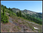
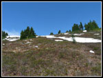
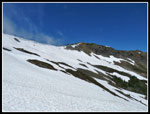
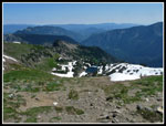
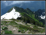
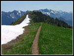
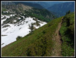
We made steady progress. While the trail is not too steep there are a number of big steps that slowed us down. Recent trip reports were cryptic with no photos so just where the snow began was a mystery. The route becomes more gentle when it leaves the south slope and heads north. Somewhere around 5800' we began to see snow. The trail alternated between a few feet of snow and bare trail. Up on the ridge top the trail disappeared under snow as it began to sidehill on the left side of the ridge. Rather than sidehill I chose to stay on the ridge top. Brush is not bad and we made easy progress. Glacier lilies were just poking up as the slope became steeper. Part bare and part snowy it was easy to gain elevation.
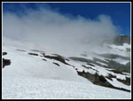
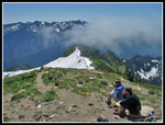
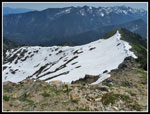
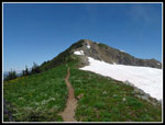
At some point we crossed the trail and found it again coming from the left. We reached the ridge near the Rock Lake - Rock Mountain junction of the Nason Ridge Trail. Now at 6200', we had gained 3400' with just 600' to go to the summit. The ridge was mostly snow with some bare dirt in groves of trees. Janet chose to stop here but gave me the okay to try for the summit. The wind was now howling and I put on a jacket for the ascent. The summit ridge was still corniced. At the far left there was some bare heather. This is the area of the summer trail. I figured I'd give it a shot.
We had heard a motor a few minutes earlier and as I hiked along the ridge I saw and talked with a guy with a chain saw. I have no idea what was to be cut way up there. The route steepened and I pulled out my ice axe. The snow was soft enough for good steps with little if any exposure. I left the snow and climbed a short bit of heather to intersect the summer trail. It switchbacked up the heather. Near the ridge top I chose to head left around the snow rather than climb a short very steep bit. Once on the ridge top the bare dirt trail was visible all the way to the summit. Hiking along the ridge I could see much of the Snowy Creek trail. It was nearly snow free. That is an easier way to the summit of Rock now until the snow finally felts out on the Highway 2 route.
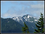
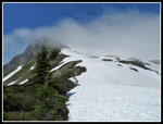
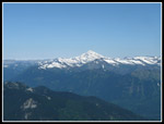
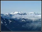
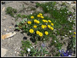
Lots of flowers all along the summit ridge. A real showcase of colors. Reds, yellows, whites, and blues. It took me about 40 minutes from where I left Janet to the summit. It was 12:50 when I reached the summit. Two women were already there. They came up Snowy Creek. Down at the ridge the summit was in and out of clouds. Now it had cleared up. It was still cloudy to the west but crystal clear looking north to Glacier Peak. The north side of Mt. Daniel was still plastered with snow. Much more than usual for August.
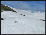
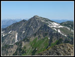
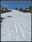
My summit stay was short. Within 10 minutes I was on my way down. The descent went fast. The steep heather was slick but once on the dirt trail it took only a few minutes to get back onto the snow. I glissaded most of the way back down. In less than 20 minutes I was back on the ridge. Janet and I were soon descending. I was able to standing glissade much of the steeper snow. The rest of the way down was easy. We saw 4 or 5 groups on the day. Most of them before the snow began. We had time to admire the flower show and the views across to the Chiwaukum peaks, Arrowhead Mountain, and Jim Hill Mountain. When we reached the car there seemed to be more cars than people seen.
This trip recalled why I enjoy the route. Many short switchbacks to get you up the mountain, some fun snow travel, and great summit views. Janet pushed her elevation gain to 9000' in the past 8 days. Some day I'll hike this trail late in the year and actually see the trail near and above the Nason Ridge junction. Until then I'll just enjoy the snow up high. A great day on a great trail.
Click on thumbnails to get
larger pictures.
Trips - 2011
Home
The trail is easy to describe. Many short switchbacks. It is not all that steep but it climbs relentlessly. Forest gives way to open slopes and more forest. It would be awfully hot in mid afternoon heading up but was not too bad with our early start. We had overcast and even a little drizzle all the way to within a few miles of the trailhead. We were under blue sky but it was dark and gray just to the west. It was also much windier than expected. That was not all bad as it kept us cooler on that sun baked south slope. The flower shop continued with roses, lupine, paintbrush, and a whole lot of blooming tiger lilies. In places the slope was away in bright yellow and red stonecrop.
We made steady progress. While the trail is not too steep there are a number of big steps that slowed us down. Recent trip reports were cryptic with no photos so just where the snow began was a mystery. The route becomes more gentle when it leaves the south slope and heads north. Somewhere around 5800' we began to see snow. The trail alternated between a few feet of snow and bare trail. Up on the ridge top the trail disappeared under snow as it began to sidehill on the left side of the ridge. Rather than sidehill I chose to stay on the ridge top. Brush is not bad and we made easy progress. Glacier lilies were just poking up as the slope became steeper. Part bare and part snowy it was easy to gain elevation.
At some point we crossed the trail and found it again coming from the left. We reached the ridge near the Rock Lake - Rock Mountain junction of the Nason Ridge Trail. Now at 6200', we had gained 3400' with just 600' to go to the summit. The ridge was mostly snow with some bare dirt in groves of trees. Janet chose to stop here but gave me the okay to try for the summit. The wind was now howling and I put on a jacket for the ascent. The summit ridge was still corniced. At the far left there was some bare heather. This is the area of the summer trail. I figured I'd give it a shot.
We had heard a motor a few minutes earlier and as I hiked along the ridge I saw and talked with a guy with a chain saw. I have no idea what was to be cut way up there. The route steepened and I pulled out my ice axe. The snow was soft enough for good steps with little if any exposure. I left the snow and climbed a short bit of heather to intersect the summer trail. It switchbacked up the heather. Near the ridge top I chose to head left around the snow rather than climb a short very steep bit. Once on the ridge top the bare dirt trail was visible all the way to the summit. Hiking along the ridge I could see much of the Snowy Creek trail. It was nearly snow free. That is an easier way to the summit of Rock now until the snow finally felts out on the Highway 2 route.
Lots of flowers all along the summit ridge. A real showcase of colors. Reds, yellows, whites, and blues. It took me about 40 minutes from where I left Janet to the summit. It was 12:50 when I reached the summit. Two women were already there. They came up Snowy Creek. Down at the ridge the summit was in and out of clouds. Now it had cleared up. It was still cloudy to the west but crystal clear looking north to Glacier Peak. The north side of Mt. Daniel was still plastered with snow. Much more than usual for August.
My summit stay was short. Within 10 minutes I was on my way down. The descent went fast. The steep heather was slick but once on the dirt trail it took only a few minutes to get back onto the snow. I glissaded most of the way back down. In less than 20 minutes I was back on the ridge. Janet and I were soon descending. I was able to standing glissade much of the steeper snow. The rest of the way down was easy. We saw 4 or 5 groups on the day. Most of them before the snow began. We had time to admire the flower show and the views across to the Chiwaukum peaks, Arrowhead Mountain, and Jim Hill Mountain. When we reached the car there seemed to be more cars than people seen.
This trip recalled why I enjoy the route. Many short switchbacks to get you up the mountain, some fun snow travel, and great summit views. Janet pushed her elevation gain to 9000' in the past 8 days. Some day I'll hike this trail late in the year and actually see the trail near and above the Nason Ridge junction. Until then I'll just enjoy the snow up high. A great day on a great trail.
 Arrowhead Mountain |
 Janet On Trail |
 Jim Hill Mountain |
 Lupine & Tiger Lilies |
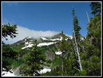 Clouds On Ridge |
 Wet Trail |
 Heading Uphill |
 Janet On Ridge |
 Summit In Clouds |
 Heading Up The Snow |
 Summit Is Now Clear |
 Climbing To Heather |
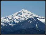 Glacier Peak |
 View North |
 Mt. Howard |
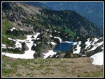 Rock Lake |
 View Southeast |
 Summit Company |
 Daniel & Hinman |
 Ridge I Came Up |
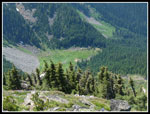 Snowy Creek Meadow |
 Snowy Ridge Up |
 Daisy Like Flowers |
 Indian Paintbrush |
 Ridge Walking |
 Rock Summit |
 Trail Junction |
 Descending Heather |
 Glissade Tracks |
 Tiger Lilies |
Trips - 2011
Home