1-28-12
This
was my third trip up Hex Mountain. All of them have been on snow. In
the summer you can drive 2 miles up the road to the trailhead which is
only 2 miles from the summit. Starting at the main road makes it a
longer and more interesting trip. On the first visit with a Mountaineer
group in 2001 we had very strong winds on the open ridge. Almost knock
you over strong wind. At the summit it was just a mild breeze. Brutal
wind in the same place coming down. I have read other trip reports
mentioning the same thing. On my second
visit, just last winter, Janet
and I had overcast but pretty gentle wind. Both trips had white sky and
white peaks. Not the best for views.
For this trip our motley group of 8 met in Bellevue and consolidated into two cars for the drive east. From the roundabout entering Roslyn it is 8.5 miles to the start. The siding just before Newport Creek was plowed with room for half a dozen cars. One was already there. The duo left a little ahead of us and stayed ahead of us all day. It was an overcast day. Our plan to head east might have avoided a little rain but did not give us any blue sky. With the snotel site on Sasse Ridge showing a two week gain from 48 inches of snow to 83 inches I feared for a lot of soft new snow. That never was a problem.
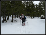
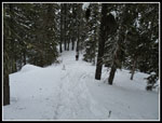
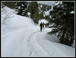
We arrived a little before 9:00 am and were packed and moving at about 9:15 am. We walked down the road a short way to the start of the road we needed. The snow was firm enough to walk on a short way but we soon stopped to put on snowshoes. The snow level was exactly even with the top of the gate so we walked right over it. On my first visit one simply walked the road to the trailhead. On last winter's trip I found that there are now more roads. A sign mentioned ten building lots. One can take a mistaken route. One did.
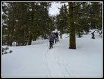
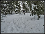
The road was clear enough until we reached a major junction. Right was a road with just a few tracks. To the left were more tracks. The left road immediately splits again. The right and uphill road had the most tracks on it. That's the way we went. The first right turn would be correct to follow the main road to the summer trailhead. Our route climbed and soon it did not look at all familiar. The GPS confirmed we were on a different route. Rather than turn around we looked to get over the ridge to our right and back on track.
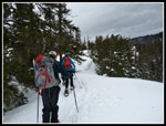
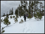
A few moments later the track did exactly that. It headed straight up to the ridge top. The correct road was now below us on the right. The tracks continued along the ridge as it descended. We followed the tracks. At the low point we could have dropped about 150' to the road. Instead we climbed steeply over a forested bump, dropped a little, and found an old road. This road began a rightward curve towards the trailhead. In fact, it soon met the main road beyond the summer trailhead. Our tracks angled uphill and quickly met the summer trail. The new route we took is a little shorter with a little more elevation gain. All in all, it worked just fine.
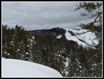
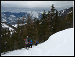
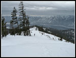
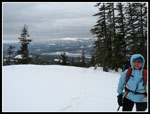
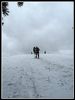
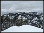
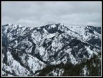
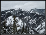
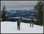
The summer route stays near the crest of the ridge as it steadily gains elevation. It is in thin forest with a few views out. We reached a high point with views out to Kachess Ridge, Cle Elum Lake, and the summit of Hex Mountain. The sky was white but views were not too bad. The ridge descends a little to a saddle then begins a steady climb. This area was clear cut before my first visit. This is where we had the strong winds. this day was almost wind free... until we reached that point. The wind was immediately strong and very cold. Too strong for a ball cap. It would have blown away. A wool hat helped and then it was just a slog up the slope.
The snow was surprisingly good. Firm with good grip but not icy. Taking off a glove to get a photo was not appealing. I took just a few photos along here. At least I knew that forest lay ahead. Not sure I would have wanted to stay on an open ridge with that much wind. It was strong but not as bad as on my first visit. Not strong enough to knock you over. At long last we reached forest and most of the wind was blocked. It felt about 30 degrees warmer.
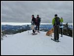
Our route now wound through the trees at a gentler grade. At the top of Sasse Ridge we turned to the right for the last bit to the top of Hex Mountain. A little below the summit we met the two other snowshoers. They had gone up then retreated to the forest for lunch. The last bit is steeper but with good snow conditions it was no problem. On top there was wind but nothing like on the ridge below. We arrived at 12:05 pm taking just under 3 hours to come up. We took time to admire the view and for a group photo. Then it was time to drop down out of the cold for lunch. My thermometer showed it to be just around freezing though it felt much colder. I put on two more layers.
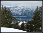
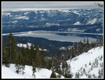
After a 20 minute lunch break I put on my warmest mittens but had two very cold hands. Within 15 minutes we were back at the blast zone. It was blowing just as hard if not harder. Far below I could see a near perfect reflection in Cle Elum Lake. Not the least bit of wind down there. I had a tough time taking photos with numb fingers. Just a few along this stretch. Another 15 minutes brought us back to the saddle and the end of the worst wind. A little farther down the ridge it was calm once again. For the return we chose to take the main road. We reached the road at the summer trailhead. The two mile road walk went by pretty fast. At about the time we reached the "wrong turn" junction light rain began to fall. So much for heading east to avoid rain.
We reached the cars at about 2:00 pm. Just 1 1/2 hours to descend. As we finished packing our gear it began to rain harder. Good timing. This is a fun winter snowshoe trip. Some road walking and a great open ridge walk. The summit has pretty good views too. Totals for the day were about 7 1/2 miles with 2800' of gain. Knock off 100' if you take the road both ways. This was a fun trip with a good group. After hiking up two years in a row it might be awhile before I return.
Click on thumbnails to get
larger pictures.
Trips - 2012
Home
For this trip our motley group of 8 met in Bellevue and consolidated into two cars for the drive east. From the roundabout entering Roslyn it is 8.5 miles to the start. The siding just before Newport Creek was plowed with room for half a dozen cars. One was already there. The duo left a little ahead of us and stayed ahead of us all day. It was an overcast day. Our plan to head east might have avoided a little rain but did not give us any blue sky. With the snotel site on Sasse Ridge showing a two week gain from 48 inches of snow to 83 inches I feared for a lot of soft new snow. That never was a problem.
We arrived a little before 9:00 am and were packed and moving at about 9:15 am. We walked down the road a short way to the start of the road we needed. The snow was firm enough to walk on a short way but we soon stopped to put on snowshoes. The snow level was exactly even with the top of the gate so we walked right over it. On my first visit one simply walked the road to the trailhead. On last winter's trip I found that there are now more roads. A sign mentioned ten building lots. One can take a mistaken route. One did.
The road was clear enough until we reached a major junction. Right was a road with just a few tracks. To the left were more tracks. The left road immediately splits again. The right and uphill road had the most tracks on it. That's the way we went. The first right turn would be correct to follow the main road to the summer trailhead. Our route climbed and soon it did not look at all familiar. The GPS confirmed we were on a different route. Rather than turn around we looked to get over the ridge to our right and back on track.
A few moments later the track did exactly that. It headed straight up to the ridge top. The correct road was now below us on the right. The tracks continued along the ridge as it descended. We followed the tracks. At the low point we could have dropped about 150' to the road. Instead we climbed steeply over a forested bump, dropped a little, and found an old road. This road began a rightward curve towards the trailhead. In fact, it soon met the main road beyond the summer trailhead. Our tracks angled uphill and quickly met the summer trail. The new route we took is a little shorter with a little more elevation gain. All in all, it worked just fine.
The summer route stays near the crest of the ridge as it steadily gains elevation. It is in thin forest with a few views out. We reached a high point with views out to Kachess Ridge, Cle Elum Lake, and the summit of Hex Mountain. The sky was white but views were not too bad. The ridge descends a little to a saddle then begins a steady climb. This area was clear cut before my first visit. This is where we had the strong winds. this day was almost wind free... until we reached that point. The wind was immediately strong and very cold. Too strong for a ball cap. It would have blown away. A wool hat helped and then it was just a slog up the slope.
The snow was surprisingly good. Firm with good grip but not icy. Taking off a glove to get a photo was not appealing. I took just a few photos along here. At least I knew that forest lay ahead. Not sure I would have wanted to stay on an open ridge with that much wind. It was strong but not as bad as on my first visit. Not strong enough to knock you over. At long last we reached forest and most of the wind was blocked. It felt about 30 degrees warmer.
Our route now wound through the trees at a gentler grade. At the top of Sasse Ridge we turned to the right for the last bit to the top of Hex Mountain. A little below the summit we met the two other snowshoers. They had gone up then retreated to the forest for lunch. The last bit is steeper but with good snow conditions it was no problem. On top there was wind but nothing like on the ridge below. We arrived at 12:05 pm taking just under 3 hours to come up. We took time to admire the view and for a group photo. Then it was time to drop down out of the cold for lunch. My thermometer showed it to be just around freezing though it felt much colder. I put on two more layers.
After a 20 minute lunch break I put on my warmest mittens but had two very cold hands. Within 15 minutes we were back at the blast zone. It was blowing just as hard if not harder. Far below I could see a near perfect reflection in Cle Elum Lake. Not the least bit of wind down there. I had a tough time taking photos with numb fingers. Just a few along this stretch. Another 15 minutes brought us back to the saddle and the end of the worst wind. A little farther down the ridge it was calm once again. For the return we chose to take the main road. We reached the road at the summer trailhead. The two mile road walk went by pretty fast. At about the time we reached the "wrong turn" junction light rain began to fall. So much for heading east to avoid rain.
We reached the cars at about 2:00 pm. Just 1 1/2 hours to descend. As we finished packing our gear it began to rain harder. Good timing. This is a fun winter snowshoe trip. Some road walking and a great open ridge walk. The summit has pretty good views too. Totals for the day were about 7 1/2 miles with 2800' of gain. Knock off 100' if you take the road both ways. This was a fun trip with a good group. After hiking up two years in a row it might be awhile before I return.
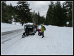 Plowed Parking |
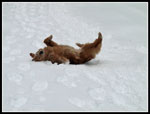 Gus Likes Snow |
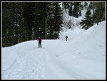 Snowshoeing The Road |
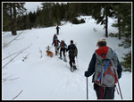 Off Road Now |
 Short Steep Climb |
 On Summer Trail |
 Hex Summit |
 Cornice Forming |
 Dropping To Saddle |
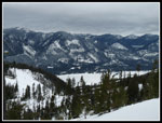 Kachess Ridge |
 Starting Up Clear Cut |
 Looking Down Clear Cut |
 Leaving Windy Ridge |
 Back In Forest |
 Last Climb To Summit |
 View North |
 Summit View |
 Group On Summit |
 Ridge & Lake |
 Last Summit View |
 Dropping Off Summit |
 Back In The Wind |
 No Wind On Lake |
 Summer Trailhead |
 Heading Down Road |
Trips - 2012
Home