4-28-12
Janet
wanted to head east and I was in agreement. We were looking for a snow
free trail with some elevation gain and sunshine. Her suggestion was
Icicle Ridge. I have done that trail a number of times but not in the
past 10 years. Time for a return visit. This was the WTA hike of the
week and there were two trip reports from the previous week. With that
in mind we headed out early. We met in Monroe at 6:55 am and headed
east. Very cloudy at Stevens Pass but the sky began to clear farther
east. We cruised into Leavenworth and took a right turn on Icicle Creek
Road. 1.4 miles later another right turn and into the parking lot. On
my last visit there was a parking lot. Now there is a circular road
with parking along side. More parking on the lower road. There were
only a few cars when we arrived. 86 miles from the smokestack in Monroe
and 119 from my place in North Seattle. By 8:45 am we were packed and
on our way.
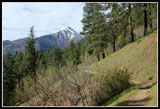
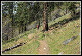
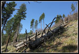
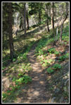
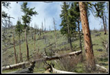
The forecast was for partly cloudy but it was bright sunshine most of the day. There were a few clouds by the time we were heading down. Some flowers in bloom right from the start. Waterleaf, spring beauty, and balsamroot especially. Not a real flower show yet but not very far away either. The trail is gently graded yet gains elevation at a steady rate. There were five groups signed in ahead of us and several were coming down already. The route is in and out of open forest. Open enough to provide views out but providing more shade than I recalled. My last visit was soon after a fire burned nearly to the houses below the lower trail. Time has rapidly healed the burn. Mostly just blackened bark on evergreen trees to show the damage. It was cool at the start but quickly warmed up. I soon rolled up my sleeves and then zipped off my pants legs. Nice to be out hiking in shorts and short sleeves again.
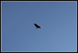
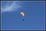
With the good early morning sun we stopped frequently for flower photos. No great hurry this day. There is no destination on this hike. At least not for an early season day hike. The trail goes on to the Cascade Crest but there is no "summit" to aim for. The trail makes many easy switchbacks. In some places the route crosses a much steeper trail. It looks like there was an original trail that headed higher fast without all the switchbacks and long traverses. The current trail is very easy on the knees. We say a flock of what looked like vultures circling above us. Not the most comforting site. The thermals allowed them to soar higher and higher.
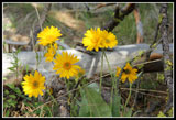
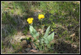
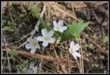
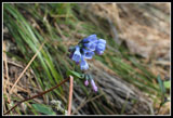
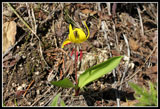
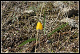
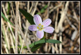
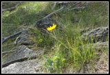
The balsamroot were mostly blooming near the start of the trail. most were near peak. higher up we saw many leaves just poking up. It will be a few weeks before all those flowers are blooming. Spring beauty was everywhere. Big ones, medium ones, and small ones. Mostly white with a few more colorful. We did see some bluebells, yellow bells, and glacier lilies. While the conditions seemed ideal for glacier lilies with recent snow melt we did not see many of them. The trailhead is at about 1300'. At about 3000' the trail nears a saddle on the ridge top. We stopped at the saddle for a food and water break. For the first time you can look down on the north side of the ridge to Tumwater Canyon, the Wenatchee River, and Highway 2. There is still snow on the north side of the ridge though we had seen none on our south side route to that point.
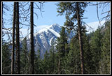
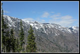
Our stop was short and we headed higher. There will be lots of color in a few weeks on open rocky slopes. Just a few glacier lilies, yellow bells, and spring beauty for now. Once it hits the ridge the trail switchbacks below on the south side with a few more ridge top view opportunities. It was 11:20 at the next ridge top spot and time for lunch. Still almost snow free at 3400'. Really nice views from the ridge top looking north. Tumwater Mountain is just across the valley.
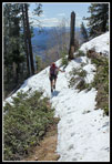
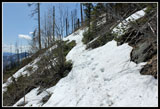
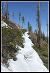
By the time we reached the ridge again at about 4000' we had a few snowy stretches on the trail. Not much and it will be gone soon. There was clearly more snow ahead. I hoped to get up to a view towards the Stuart Range and went ahead while Janet enjoyed a viewpoint break. The snow soon covered the trail. It was tedious as every few steps it I would sink knee deep in snow that is not much more than knee deep total depth. Before the next switchback I met a group we had passed and been passed by several times. They did not go much farther and had had enough of the post holing. The slope is quite steep here and falling off the snowy trail would not be much fun.
I continued on and at the switchback I tried to go straight to get a view to the southwest. I immediately sank to my crotch. Maybe that was not such a good idea. I continued up the snowy trail and soon came tot he conclusion the other group did. Not worth the effort. At about 4200' I turned around. In short order I was back to Janet on the ridge. The trip down was easy. The steady smooth grade was a pleasure to hike. There are half a dozen trees down across the trail but none proved to be much of a problem. In one place folks have cut below the trail to get over and have collapsed the hillside. The sooner that log is cut out the less damage will be done.
On the way down we met a whole lot of folks coming up. Enough to more than fill the parking spaces. It did look like a "hike of the day" crowd. I was even more pleased that we started early. It was still pretty early when we finished so we drove to the end of the Icicle Creek Road. Lots of balsamroot in full bloom on the exposed southern slopes. The road is snow free to where it is blocked a little beyond mile post 11. Snow covers the road beyond that point. No snow at the Fourth of July trailhead. Coming home early on a Saturday left us with an easy drive on Highway 2.
This was a great choice for the day. Sunshine all day long but not nearly as hot as the day on snow at Mazama Ridge the week before. No snow for most of the trip and no bugs. Not many people until the last few miles coming down. Some wildflowers and signs that they will be great in a few weeks here. A very pleasant way to spend a Saturday in April.
Click on thumbnails to get
larger pictures.
Trips - 2012
Home
The forecast was for partly cloudy but it was bright sunshine most of the day. There were a few clouds by the time we were heading down. Some flowers in bloom right from the start. Waterleaf, spring beauty, and balsamroot especially. Not a real flower show yet but not very far away either. The trail is gently graded yet gains elevation at a steady rate. There were five groups signed in ahead of us and several were coming down already. The route is in and out of open forest. Open enough to provide views out but providing more shade than I recalled. My last visit was soon after a fire burned nearly to the houses below the lower trail. Time has rapidly healed the burn. Mostly just blackened bark on evergreen trees to show the damage. It was cool at the start but quickly warmed up. I soon rolled up my sleeves and then zipped off my pants legs. Nice to be out hiking in shorts and short sleeves again.
With the good early morning sun we stopped frequently for flower photos. No great hurry this day. There is no destination on this hike. At least not for an early season day hike. The trail goes on to the Cascade Crest but there is no "summit" to aim for. The trail makes many easy switchbacks. In some places the route crosses a much steeper trail. It looks like there was an original trail that headed higher fast without all the switchbacks and long traverses. The current trail is very easy on the knees. We say a flock of what looked like vultures circling above us. Not the most comforting site. The thermals allowed them to soar higher and higher.
The balsamroot were mostly blooming near the start of the trail. most were near peak. higher up we saw many leaves just poking up. It will be a few weeks before all those flowers are blooming. Spring beauty was everywhere. Big ones, medium ones, and small ones. Mostly white with a few more colorful. We did see some bluebells, yellow bells, and glacier lilies. While the conditions seemed ideal for glacier lilies with recent snow melt we did not see many of them. The trailhead is at about 1300'. At about 3000' the trail nears a saddle on the ridge top. We stopped at the saddle for a food and water break. For the first time you can look down on the north side of the ridge to Tumwater Canyon, the Wenatchee River, and Highway 2. There is still snow on the north side of the ridge though we had seen none on our south side route to that point.
Our stop was short and we headed higher. There will be lots of color in a few weeks on open rocky slopes. Just a few glacier lilies, yellow bells, and spring beauty for now. Once it hits the ridge the trail switchbacks below on the south side with a few more ridge top view opportunities. It was 11:20 at the next ridge top spot and time for lunch. Still almost snow free at 3400'. Really nice views from the ridge top looking north. Tumwater Mountain is just across the valley.
By the time we reached the ridge again at about 4000' we had a few snowy stretches on the trail. Not much and it will be gone soon. There was clearly more snow ahead. I hoped to get up to a view towards the Stuart Range and went ahead while Janet enjoyed a viewpoint break. The snow soon covered the trail. It was tedious as every few steps it I would sink knee deep in snow that is not much more than knee deep total depth. Before the next switchback I met a group we had passed and been passed by several times. They did not go much farther and had had enough of the post holing. The slope is quite steep here and falling off the snowy trail would not be much fun.
I continued on and at the switchback I tried to go straight to get a view to the southwest. I immediately sank to my crotch. Maybe that was not such a good idea. I continued up the snowy trail and soon came tot he conclusion the other group did. Not worth the effort. At about 4200' I turned around. In short order I was back to Janet on the ridge. The trip down was easy. The steady smooth grade was a pleasure to hike. There are half a dozen trees down across the trail but none proved to be much of a problem. In one place folks have cut below the trail to get over and have collapsed the hillside. The sooner that log is cut out the less damage will be done.
On the way down we met a whole lot of folks coming up. Enough to more than fill the parking spaces. It did look like a "hike of the day" crowd. I was even more pleased that we started early. It was still pretty early when we finished so we drove to the end of the Icicle Creek Road. Lots of balsamroot in full bloom on the exposed southern slopes. The road is snow free to where it is blocked a little beyond mile post 11. Snow covers the road beyond that point. No snow at the Fourth of July trailhead. Coming home early on a Saturday left us with an easy drive on Highway 2.
This was a great choice for the day. Sunshine all day long but not nearly as hot as the day on snow at Mazama Ridge the week before. No snow for most of the trip and no bugs. Not many people until the last few miles coming down. Some wildflowers and signs that they will be great in a few weeks here. A very pleasant way to spend a Saturday in April.
 Blooming Balsamroot |
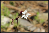 Woodland Star |
 Lone Balsamroot |
 Traversing Trail |
 Two Balsamroots |
 Big Bird |
 Janet Is Ahead |
 All Blue Sky |
 Wedge Mountain |
 Back In Shade |
 Spring Beauty |
 Bluebells |
 Yellow Stamens |
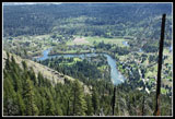 Wenatchee River |
 Yellow Bells |
 Single Spring Beauty |
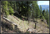 Continuing to Ascend |
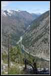 Tumwater Canyon |
 Snow On North Side |
 Now On Snow |
 Sinking In With Each Step |
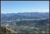 Leavenworth Is Below |
 Turn Around Point |
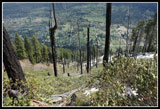 Old Burn |
 Para Glider |
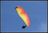 Close Up Glider |
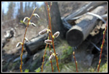 Signs Of Spring |
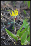 Glacier Lily |
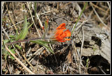 Indian Paintbrush |
 Looking Up To Ridge |
 Glowing Balsamroot |
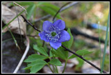 Oregon Anemone |
Trips - 2012
Home