6-02-12
I
had a rare Saturday business
meeting on Puyallup's South Hill. It was scheduled for 9:00 am so I
planned to get in a hike while in the area. Pack Forest is not too much
farther south. My last
visit to Pack Forest was after a
meeting with
the same clients back in 2002. Ten years later I returned for my fourth
visit. I headed straight down Highway 161 through Eatonville to Highway
7. A left turn and the entrance was just ahead on the left. I parked
right by the highway next to the Hugo Peak trail. I was on the trail at
11:35 am. It had rained for much of my drive and it was very gray but
dry when I started.
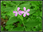
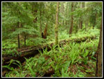
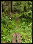
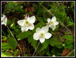
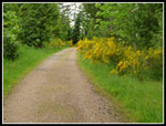
A number of wildflowers are blooming at lower levels. I did not see any trillium. They are probably done for the year. A sign asked hikers to try not to walk on the calypso orchids. I have seen a lot of them this spring but none this day. My decision not to wear rain pants was a bad one. While the trail is not overly brushy the wet brush did hang across it and I was soon soaked. On went the rain pants, though a bit late. The sign at the start says it is 2.5 miles to Hugo Peak. My GPS registered exactly 2 miles. The flats at the bottom were muddy but the trail has numerous boardwalks to get you across. My lightweight boots were soon soaked and stayed that way all day.
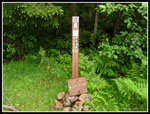
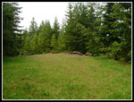
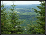
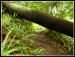
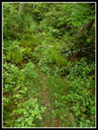
I was surprised that this trail has not received much/any maintenance so far this year. There are a number of trees down. None proved to be much trouble to get around. There are a few spots with views in old clear cuts. Not much of a view this day. Mostly just other peaks in the clouds. With the recent rain and overcast the green forest was really green. Great colors. Dripping moss all over the place. The route is never steep as it climbs up Hugo Peak. Near the top are a number of old grassy roads all well signed to keep you on track. All I could recall about the summit was that it was a flat meadow with few views. The flat part was correct. Several benches sit at one end by an opening in the trees. Not much to see but clouds this day.
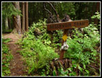
Since I had a late start I had a late lunch on top of Hugo. I pulled out my map and planned out the rest of the day. I knew I wanted to finish with a visit to Little Mashel Falls. My initial itinerary changed a few times as I went along. From Hugo Peak I dropped down to Kirkland Pass going by the Reservoir Trail. I have done that one before but planned on bypassing it today. Kirkland Pass is the center of Pack Forest. Five roads/trails meet here and one hikers only trail. How could I not head out on the Trail Of The Giants?SS
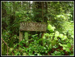
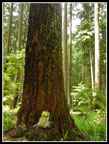
This trail goes through an area kept as old growth. The sign mentions that a fire swept through in 1800 with some trees surviving. The others are "only" up to 212 years old. There are a number of big trees along this trail. It is a must see place in Pack Forest. The trail has not seen much recent upkeep as there were again a number of trees down across the trail. Add a little mud to the wet brush and I was dripping soon enough. It is a fun narrow trail with enough big trees to keep me entertained. The trail drops then climbs up to a road. Across the way is the trail to Windy Ridge. I have done that one before so I chose to turn right on the road.
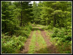
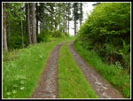
For the most part the roads in Pack Forest are not rock hard gravel. Mostly pretty easy on the feet. Many have grass growing down the middle. There were more views out along here but once again not much but gray clouds to see. I always add at least one new trail on each visit and this time I headed for the New Forestry trail. A new trail? Maybe in excellent shape? I took a right then a left as the road began a gentle descent. There were no maps in the map boxes around the route but I printed one at home. Add in the GPS which did not have all the roads or trails and I had enough info though I had to stop occasionally to puzzle out where to go next.
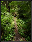
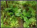
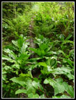
I found the New Forestry trail easily enough. It was definitely not a new trail. It is more of a route than trail. In forested places there is real tread. In other places just a slightly wider spot in the grass or bushes. If my boots had been dry before they stood no chance of remaining that way. There are some very big skunk cabbage leaves growing on the trail. I had to lift them up in one place to see where to go. There are yellow diamonds nailed to trees all along the route so I was in no danger of losing the way. A most interesting trail. Very different from the one up Hugo Peak. The trail dumped me out on a road that was not on my GPS. From the paper map I figured my position. A left turn then a right and I was heading up to Windy Ridge.
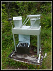
An obvious left turn took me to the top of Windy Ridge. There is a tower up there now. I descended back to the road and went left. This route makes a circle back to Kirkland Pass. On the way I made one more short jaunt to the high point of Pack Forest at 2040'. There is another memorial plaque up there. To the south I saw some very black clouds heading my way. Overhead it was actually sunny for the first time all day. I had dumped the rain pants after the New Forestry trail and my pants were finally drying out. It was easy walking with a gentle descent back to Kirkland Pass. At the pass I chose to take the road down to the falls. My umbrella soon came out as those black clouds were now overhead and spitting rain. The road makes a sharp turn to the left at a water tower and continues to drop.
A road came in on the right and I pulled out the map. I thought it might be the road over to the falls. This one headed uphill and I thought the falls access road was flatter. I chose to take the new road. I was incorrect. By the time I was sure I was on the wrong road I was half a mile along. Well, I was out to get in some miles this day. Mission accomplished. I came back down and continued down the road. A little farther along the terrain flattened and a road headed off to the right. It was marked as "falls". Yep, that's the one. The trail to the falls is not well marked. A boot path heading left across some grass seemed familiar and I took it. That part was correct. It immediately crosses a grassy road. Coming out I took the grassy road out to the road I came in on and there is a rock with "falls" painted on it.
The trail sits on a bluff above the Little Mashel River. The river is far below. It winds through forest with a number of boot paths going over the lip of the bluff. I recalled a steep trail that dropped to the top of the middle and bottom of the lower falls. After going a ways I decided to go back to one of the descending paths. It was very steep and slick with mud. I turned around and headed back where I just came from. This time I went farther. The Falls trail continues well beyond the falls turn off, at least on the map. At a slightly bigger boot path I turned off and began to drop off the bluff. It was muddy and steep with a few trees down across it but it was the correct route.
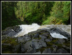
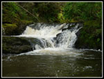
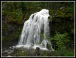
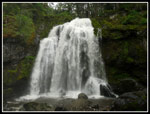
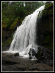
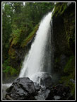
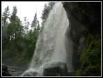
I reached a trail going right and left parallel to the river and turned right. This brought me to the middle falls. It was very loud as the water cascades over the small middle falls then drops down the larger 125' lower falls. You can stand right at the top of the big falls. After a short stay I went back to the descending trail and followed it down. On my other visits the last 50' was a slick scramble. Now the trail goes all the way to the bottom. It is very muddy at the end. There is a great viewpoint before the last drop. The falls is right in front of you. I could hear voices but not see anyone. Huh? Where were they? I put on a rain coat and went to the base of the falls. The noise was deafening. Much more water coming over the falls than on my previous visits. Lots of spray. I went to the right to get out of the spray. There I spied the people behind the voices.
Four teenagers were coming out from behind the falls. I went over to talk. They said it was easy enough to get back there. As they left I decided to go take a look. I should have put my rain pants back on. I did not. The slabs of rock were as slick as ice, maybe slicker. It was all I could do not to fall down. Low and behold the path did go right behind the falls. I'm not saying it is risk free or that everyone should try but it was neat to climb back there. Very loud. I was surprised to be able to see through the falling water. It was not dry. My pants were completely soaked in seconds. I managed to get a short movie without ruining my camera though it was plenty wet.
With all the fun done I headed back up the trail. Those four kids were the only people I saw in a 6 1/2 hour trip. Climbing back up the muddy trail was easier than descending. I retraced my steps back to the main loop road and followed it back. It ends at the main administration area and hikers parking lot. I just had to walk the paved road back to the highway and my car. I arrived at 6:00 pm. It was a fun day with some good trails, some less good trails, easy road walking, a big waterfall, some rain, and almost no other people. If you have to work on a weekend it's nice to still get in a hike somewhere you seldom visit. It was late enough that the traffic on Meridian was only somewhat bad instead of gridlock. A small price to pay for a fun day in the forest.
Click on thumbnails to get
larger pictures.
Trips - 2012
Home
A number of wildflowers are blooming at lower levels. I did not see any trillium. They are probably done for the year. A sign asked hikers to try not to walk on the calypso orchids. I have seen a lot of them this spring but none this day. My decision not to wear rain pants was a bad one. While the trail is not overly brushy the wet brush did hang across it and I was soon soaked. On went the rain pants, though a bit late. The sign at the start says it is 2.5 miles to Hugo Peak. My GPS registered exactly 2 miles. The flats at the bottom were muddy but the trail has numerous boardwalks to get you across. My lightweight boots were soon soaked and stayed that way all day.
I was surprised that this trail has not received much/any maintenance so far this year. There are a number of trees down. None proved to be much trouble to get around. There are a few spots with views in old clear cuts. Not much of a view this day. Mostly just other peaks in the clouds. With the recent rain and overcast the green forest was really green. Great colors. Dripping moss all over the place. The route is never steep as it climbs up Hugo Peak. Near the top are a number of old grassy roads all well signed to keep you on track. All I could recall about the summit was that it was a flat meadow with few views. The flat part was correct. Several benches sit at one end by an opening in the trees. Not much to see but clouds this day.
Since I had a late start I had a late lunch on top of Hugo. I pulled out my map and planned out the rest of the day. I knew I wanted to finish with a visit to Little Mashel Falls. My initial itinerary changed a few times as I went along. From Hugo Peak I dropped down to Kirkland Pass going by the Reservoir Trail. I have done that one before but planned on bypassing it today. Kirkland Pass is the center of Pack Forest. Five roads/trails meet here and one hikers only trail. How could I not head out on the Trail Of The Giants?SS
This trail goes through an area kept as old growth. The sign mentions that a fire swept through in 1800 with some trees surviving. The others are "only" up to 212 years old. There are a number of big trees along this trail. It is a must see place in Pack Forest. The trail has not seen much recent upkeep as there were again a number of trees down across the trail. Add a little mud to the wet brush and I was dripping soon enough. It is a fun narrow trail with enough big trees to keep me entertained. The trail drops then climbs up to a road. Across the way is the trail to Windy Ridge. I have done that one before so I chose to turn right on the road.
For the most part the roads in Pack Forest are not rock hard gravel. Mostly pretty easy on the feet. Many have grass growing down the middle. There were more views out along here but once again not much but gray clouds to see. I always add at least one new trail on each visit and this time I headed for the New Forestry trail. A new trail? Maybe in excellent shape? I took a right then a left as the road began a gentle descent. There were no maps in the map boxes around the route but I printed one at home. Add in the GPS which did not have all the roads or trails and I had enough info though I had to stop occasionally to puzzle out where to go next.
I found the New Forestry trail easily enough. It was definitely not a new trail. It is more of a route than trail. In forested places there is real tread. In other places just a slightly wider spot in the grass or bushes. If my boots had been dry before they stood no chance of remaining that way. There are some very big skunk cabbage leaves growing on the trail. I had to lift them up in one place to see where to go. There are yellow diamonds nailed to trees all along the route so I was in no danger of losing the way. A most interesting trail. Very different from the one up Hugo Peak. The trail dumped me out on a road that was not on my GPS. From the paper map I figured my position. A left turn then a right and I was heading up to Windy Ridge.
An obvious left turn took me to the top of Windy Ridge. There is a tower up there now. I descended back to the road and went left. This route makes a circle back to Kirkland Pass. On the way I made one more short jaunt to the high point of Pack Forest at 2040'. There is another memorial plaque up there. To the south I saw some very black clouds heading my way. Overhead it was actually sunny for the first time all day. I had dumped the rain pants after the New Forestry trail and my pants were finally drying out. It was easy walking with a gentle descent back to Kirkland Pass. At the pass I chose to take the road down to the falls. My umbrella soon came out as those black clouds were now overhead and spitting rain. The road makes a sharp turn to the left at a water tower and continues to drop.
A road came in on the right and I pulled out the map. I thought it might be the road over to the falls. This one headed uphill and I thought the falls access road was flatter. I chose to take the new road. I was incorrect. By the time I was sure I was on the wrong road I was half a mile along. Well, I was out to get in some miles this day. Mission accomplished. I came back down and continued down the road. A little farther along the terrain flattened and a road headed off to the right. It was marked as "falls". Yep, that's the one. The trail to the falls is not well marked. A boot path heading left across some grass seemed familiar and I took it. That part was correct. It immediately crosses a grassy road. Coming out I took the grassy road out to the road I came in on and there is a rock with "falls" painted on it.
The trail sits on a bluff above the Little Mashel River. The river is far below. It winds through forest with a number of boot paths going over the lip of the bluff. I recalled a steep trail that dropped to the top of the middle and bottom of the lower falls. After going a ways I decided to go back to one of the descending paths. It was very steep and slick with mud. I turned around and headed back where I just came from. This time I went farther. The Falls trail continues well beyond the falls turn off, at least on the map. At a slightly bigger boot path I turned off and began to drop off the bluff. It was muddy and steep with a few trees down across it but it was the correct route.
I reached a trail going right and left parallel to the river and turned right. This brought me to the middle falls. It was very loud as the water cascades over the small middle falls then drops down the larger 125' lower falls. You can stand right at the top of the big falls. After a short stay I went back to the descending trail and followed it down. On my other visits the last 50' was a slick scramble. Now the trail goes all the way to the bottom. It is very muddy at the end. There is a great viewpoint before the last drop. The falls is right in front of you. I could hear voices but not see anyone. Huh? Where were they? I put on a rain coat and went to the base of the falls. The noise was deafening. Much more water coming over the falls than on my previous visits. Lots of spray. I went to the right to get out of the spray. There I spied the people behind the voices.
Four teenagers were coming out from behind the falls. I went over to talk. They said it was easy enough to get back there. As they left I decided to go take a look. I should have put my rain pants back on. I did not. The slabs of rock were as slick as ice, maybe slicker. It was all I could do not to fall down. Low and behold the path did go right behind the falls. I'm not saying it is risk free or that everyone should try but it was neat to climb back there. Very loud. I was surprised to be able to see through the falling water. It was not dry. My pants were completely soaked in seconds. I managed to get a short movie without ruining my camera though it was plenty wet.
With all the fun done I headed back up the trail. Those four kids were the only people I saw in a 6 1/2 hour trip. Climbing back up the muddy trail was easier than descending. I retraced my steps back to the main loop road and followed it back. It ends at the main administration area and hikers parking lot. I just had to walk the paved road back to the highway and my car. I arrived at 6:00 pm. It was a fun day with some good trails, some less good trails, easy road walking, a big waterfall, some rain, and almost no other people. If you have to work on a weekend it's nice to still get in a hike somewhere you seldom visit. It was late enough that the traffic on Meridian was only somewhat bad instead of gridlock. A small price to pay for a fun day in the forest.
 Dripping Flowers |
 Bright Colors |
 Buttercups |
 Scotch Broom |
 Well Signed |
 Hugo Peak Summit |
 Hugo Peak View |
 Road Becoming Trail |
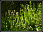 Lit Up Ferns |
 Reservoir Trail |
 Kirkland Pass |
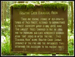 Trail Of The Giants |
 Long Nurse Log |
 Pack For Scale |
 Log Is Trail |
 I Need To Duck |
 New Forestry Trail |
 Trail? What Trail? |
 Green & Muddy |
 Big Skunk Cabbage |
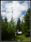 Windy Ridge Tower |
 What Is It? |
 Blue Sky! |
 Strawberry Flowers |
 Many Shades Of Green |
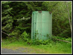 Water Tower |
 Top Of Big Falls |
 Middle Falls |
 Little Mashel Falls View |
 Straight On |
 Right Side View |
 Farther Right |
 Look Behind |
 On The Road Again |
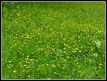 Field Of Buttercups |
 Small Lake |
Trips - 2012
Home