Day 3
Monday
morning we slept in until
8:00 am. This day we planned to take a day trip loop out Foam Creek
Basin, over to the Whitechuck Moraine, over to Red Pass, up Portal
Peak, and back to camp on the PCT. Back in 2003 we summited White
Mountain early in the morning of our last day and looked out at the
whole route. Foam Basin and the moraine looked like great places to
visit. Gary had done it long ago in the opposite direction. For John
and I it would be all new. By 9:30 am we were on our way. Our packs
were about half the weight of the first two days.
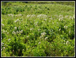
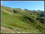
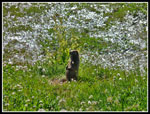
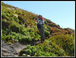
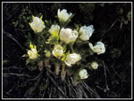
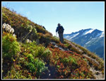
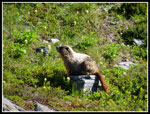
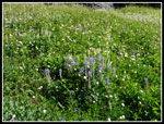
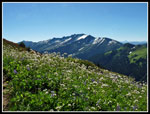
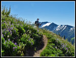
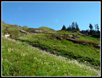
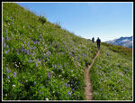
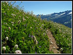
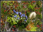
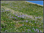
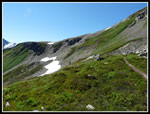
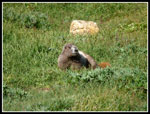
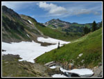
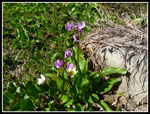
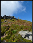
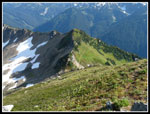
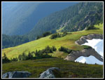
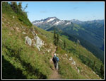
We climbed up to the PCT where I met John Porter of onehikeaweek.com. His group was returning from a successful summit of Glacier Peak. They had a break in the clouds when they were on top. As we headed up the Foam Basin trail we passed several more groups of climbers coming out. The trail traverses below the ridge top. Lots of creek crossings with water to make the slope light up with color. This is a great stretch of trail. Views out to Indian Head, Mt. David, Daniel, Hinman, Stuart, and more. Many nooks creeks lined with monkeyflower. Lots of marmots. There were still a few snow patches on this south slope though not long or steep. So much to photograph and we did. With less mileage and elevation gain planned this day we had time to enjoy. We ended up taking an average of one hour per mile hiked. Slow but a lot of fun.
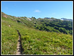
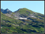
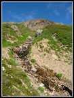
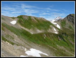
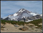
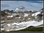
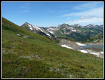
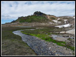
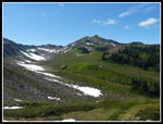
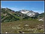
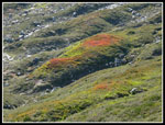
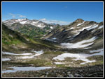
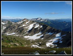
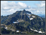
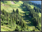
The route brought us around Point 6770. Our GPS maps showed the trail heading over the ridge a little earlier. We saw no junctions so kept heading forward. The junction is hard to miss. The high route continues forward. A big cairn marks the spot. An obvious trail heads straight uphill to the ridge crest. Up we went. Even better views on top. Our route dropped down into another valley then contoured the head and climbed up to another pass. Still a little snow on the north side of the ridge but no problem to cross. The climb to the next pass was very steep but short. This pass was fantastic. Glacier Peak was now right in our faces. Red Pass and Portal Peak were to the west. We would be there hours later. Below lay the rocky and snowy moraine of the Whitechuck. Behind and on the ridge was alpine splendor. Below us lay rocky desolation. The lake does not even show up on maps. It was under ice not too long ago.
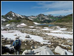
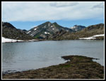
Most folks on this route are heading to climb Glacier Peak. We followed the trail down into the moraine then left it to drop down towards the lake. Below us was one lone tent, its bright yellow and blue standing out in the gray landscape. We headed down a snow slope then went onto rocks as we descended. Closer to the lake we found a big eight foot tall flat topped rock for our lunch break. What a great spot! This day was almost cloud free and warm. I was surprised to see that climbers still had a good way to go from here to Glacier Peak. We had solitude not far from the busy PCT. In fact we could see the PCT and Red Pass. Much of the rest of our route was laid out in front of us.
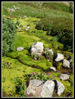
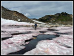
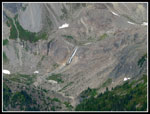
After a long lunch we headed down the last bit to the lake. There is a grassy area at the end that is bigger than a football field. Just a few big boulders in the flat grassy field. When Gary had come up many years ago they had hugged the ridge on our left. That is the route we chose for our descent. We swung around a hill just left of the lake into another creek valley. We crossed the creek and followed it down the rocky grassy slope. Once around the hill we could see down to the Whitechuck River Valley and up to Red Pass. Part way down we found a small creek where we stopped to pump more water. The bug creek to our right had an arching snow bridge across it. I could not convince Gary to try crossing it.
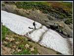
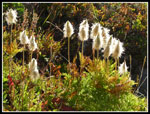
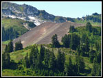
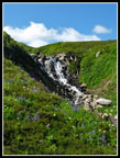
We dropped down to the flats and crossed another snowfield. Beyond that we headed straight uphill. We thought we were climbing to the PCT. Not quite. At the top we saw another drop then we could climb up to the trail. Down we went. We had one more creek to cross. It had a very photogenic waterfall lined with wildflowers in bloom. Very pretty. Atop that we crossed the creek and had a short hike up to the PCT. Now we just had another 900' of climbing to Red Pass. We had seen three backpackeers from a distance heading uphill.. We also saw a few groups heading down as we hiked uphill. One short detour was taken for a good look at the Whitechuck Cinder Cone.
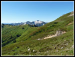
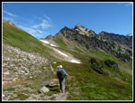
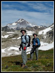
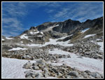
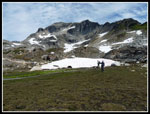
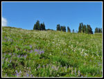
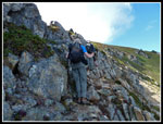
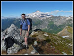
Nearing the top of the climb the heat began to get to me. We had not had any shade all day long. There is a snow patch just below Red Pass. I ground snow into my hair for an instant cooling. It really helped. A little food and water helped too. It was no surprise to see a number of folks at Red Pass. After a short break we headed up the scramble route for Portal Peak. Red Pass is at 6500' and Portal is at 6999'. About 500' up in about .28 miles. Short and steep. The bottom has some rock scrambling and the top part is just a steep trail. Not a hard scramble but it does have exposure. The top gave us a slightly different perspective of Glacier Peak. Black Mountain was now close by. Great views in all directions. We could also look down on our route from entering the moraine to Red Pass. We dropped to the pass and now just had a couple miles along the PCT back to White Pass. Easy walking with more flowers and marmots. Looking down at the camping area we could see our tents and nothing else. The crowds had headed home.
We met one person along the PCT. She was camped at White Pass. That group and us were the only ones left. After a long day hike we were ready for dinner. We had headed out at 9:30 am and did not arrive back until almost 6:00 pm. A long day for just 8.5 miles with 2400' of gain. We were beat and discussed leaving out an early morning hike up White Mountain. If so it would be almost all downhill for the last day. The exploratory day hike turned out to be probably the best day of the trip. A worthy improvement over our 2003 hike.
We climbed up to the PCT where I met John Porter of onehikeaweek.com. His group was returning from a successful summit of Glacier Peak. They had a break in the clouds when they were on top. As we headed up the Foam Basin trail we passed several more groups of climbers coming out. The trail traverses below the ridge top. Lots of creek crossings with water to make the slope light up with color. This is a great stretch of trail. Views out to Indian Head, Mt. David, Daniel, Hinman, Stuart, and more. Many nooks creeks lined with monkeyflower. Lots of marmots. There were still a few snow patches on this south slope though not long or steep. So much to photograph and we did. With less mileage and elevation gain planned this day we had time to enjoy. We ended up taking an average of one hour per mile hiked. Slow but a lot of fun.
The route brought us around Point 6770. Our GPS maps showed the trail heading over the ridge a little earlier. We saw no junctions so kept heading forward. The junction is hard to miss. The high route continues forward. A big cairn marks the spot. An obvious trail heads straight uphill to the ridge crest. Up we went. Even better views on top. Our route dropped down into another valley then contoured the head and climbed up to another pass. Still a little snow on the north side of the ridge but no problem to cross. The climb to the next pass was very steep but short. This pass was fantastic. Glacier Peak was now right in our faces. Red Pass and Portal Peak were to the west. We would be there hours later. Below lay the rocky and snowy moraine of the Whitechuck. Behind and on the ridge was alpine splendor. Below us lay rocky desolation. The lake does not even show up on maps. It was under ice not too long ago.
Most folks on this route are heading to climb Glacier Peak. We followed the trail down into the moraine then left it to drop down towards the lake. Below us was one lone tent, its bright yellow and blue standing out in the gray landscape. We headed down a snow slope then went onto rocks as we descended. Closer to the lake we found a big eight foot tall flat topped rock for our lunch break. What a great spot! This day was almost cloud free and warm. I was surprised to see that climbers still had a good way to go from here to Glacier Peak. We had solitude not far from the busy PCT. In fact we could see the PCT and Red Pass. Much of the rest of our route was laid out in front of us.
After a long lunch we headed down the last bit to the lake. There is a grassy area at the end that is bigger than a football field. Just a few big boulders in the flat grassy field. When Gary had come up many years ago they had hugged the ridge on our left. That is the route we chose for our descent. We swung around a hill just left of the lake into another creek valley. We crossed the creek and followed it down the rocky grassy slope. Once around the hill we could see down to the Whitechuck River Valley and up to Red Pass. Part way down we found a small creek where we stopped to pump more water. The bug creek to our right had an arching snow bridge across it. I could not convince Gary to try crossing it.
We dropped down to the flats and crossed another snowfield. Beyond that we headed straight uphill. We thought we were climbing to the PCT. Not quite. At the top we saw another drop then we could climb up to the trail. Down we went. We had one more creek to cross. It had a very photogenic waterfall lined with wildflowers in bloom. Very pretty. Atop that we crossed the creek and had a short hike up to the PCT. Now we just had another 900' of climbing to Red Pass. We had seen three backpackeers from a distance heading uphill.. We also saw a few groups heading down as we hiked uphill. One short detour was taken for a good look at the Whitechuck Cinder Cone.
Nearing the top of the climb the heat began to get to me. We had not had any shade all day long. There is a snow patch just below Red Pass. I ground snow into my hair for an instant cooling. It really helped. A little food and water helped too. It was no surprise to see a number of folks at Red Pass. After a short break we headed up the scramble route for Portal Peak. Red Pass is at 6500' and Portal is at 6999'. About 500' up in about .28 miles. Short and steep. The bottom has some rock scrambling and the top part is just a steep trail. Not a hard scramble but it does have exposure. The top gave us a slightly different perspective of Glacier Peak. Black Mountain was now close by. Great views in all directions. We could also look down on our route from entering the moraine to Red Pass. We dropped to the pass and now just had a couple miles along the PCT back to White Pass. Easy walking with more flowers and marmots. Looking down at the camping area we could see our tents and nothing else. The crowds had headed home.
We met one person along the PCT. She was camped at White Pass. That group and us were the only ones left. After a long day hike we were ready for dinner. We had headed out at 9:30 am and did not arrive back until almost 6:00 pm. A long day for just 8.5 miles with 2400' of gain. We were beat and discussed leaving out an early morning hike up White Mountain. If so it would be almost all downhill for the last day. The exploratory day hike turned out to be probably the best day of the trip. A worthy improvement over our 2003 hike.
 Shiny Western Anemone |
 Foam Basin Start |
 Foam Basin |
 Moss & Monkeyflower |
 Many Creeks |
 Blue Sky |
 First Marmot |
 Johnson & White Pass |
 Snow Crossing |
 Gary At Work |
 White Flowers |
 Lit Up Like Light Bulbs |
 Red Leaves |
 Another Marmot |
 Thick With Flowers |
 Flowers & Indian Head |
 Trail Through Flowers |
 Evergreens |
 Purple & White |
 Up Close |
 Gentian |
 Up On The Ridge |
 Thickest Flowers |
 Into Next Basin |
 Looking Backwards |
 Glacier Peak |
 Gary & John At Saddle |
 Upper Moraine |
 Lake Is Below |
 Third Marmot |
 Entering Moraine |
 Moraine Headwall |
 Creek To Lake |
 Grassy Field |
 Moraine Lake |
 Red Snow |
 Marmot Four |
 Green & Red |
 Leaving Moraine |
 Waterfall |
 Whitechuck Valley |
 Portal Peak |
 Whitechuck Cinder Cone |
 Looking Back |
 Flowery Waterfall |
 Flower Field |
 Shooting Stars |
 Bright Red |
 Our Route |
 Scrambling Portal Peak |
 Near Portal Summit |
 Jim On Portal Summit |
 View Southeast |
 Red Pass Below |
 Black Mountain |
 Big Waterfall |
 Bright Meadow |
 On PCT |
 White Pass Campsite |
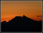 White Pass Sunset |
<< Day >>
Pilot Ridge - NF Sauk Report
Home