7-04-12
A
last minute change of plans had me looking for a long hike with minimal
snow. I have done Snoqualmie Lake via Lake Dorothy three time but never
from the Taylor River side. I have hiked the Taylor River trail but not
since 2000. Time for a return to Taylor with a new trail to Snoqualmie
Lake. After driving the usual potholed North Fork Snoqualmie Road I was
on the trail at 9:12 am. There were half a dozen cars in the lot. It
was cool but fine for shorts. The trailhead is at about 1200'
and the lake is at 3147'. Low enough to possibly be snow free.
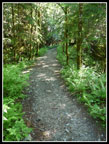
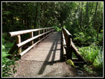
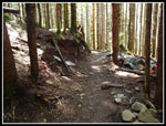
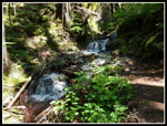
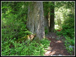
This trail has changed quite a bit in the 12 years since my last visit. After the first few miles the old road has narrowed to near trail size. There are now signs. First one for the Quartz Creek Road and also a huge cairn marking the turn off to Otter Falls. A new (to me) bridge is now at Marten Creek. The old automobile bridge has broken logs in places. It was removed and replaced with a narrow hiker bridge. Although the creeks were running fairly high I managed all the crossings with dry feet. Poles were helpful on the widest ones. It is very easy to make good time on the gentle grade. I averaged about 3.3 mph excluding a few stops.
I brought a GPS to record the distance and elevation change. Not at all necessary for navigation on this old road. I checked the GPS map at 2.73 miles and saw a trail shown just behind me. I backtracked a hundred feet and found the tread. I thought this must be the route to Otter Falls. Up I went on a steep and wet trail. As it neared a cascading creek on my right I realized that the Otter Falls trail is on the right of that creek. Oops! Zooming out the map showed that this was the trail to Marten Lake. I went up about an eighth of a mile before turning around. Well, at least I know where the trail is now. Once back on the trail I reached the bridge over Marten Creek in just a few minutes.
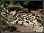
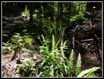
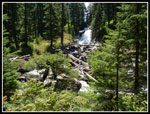
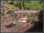
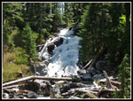
There are several creek crossings where the old road bed has been washed out. At one, there are two large culverts down the hill. In each case the creek crossing has been hacked farther into the hillside. No problems getting by. Next up was Otter Falls and Lipsy Lake. No problem finding the turn off now. A very large cairn made of rocks and blocks on the right and a smaller one on the left. The trail up is hard to follow as there are several paths. No matter, they all lead in short order to the falls. Plenty of water cascading down the rocks right now. Surprisingly, I was the only one there. I had a nice short break enjoying the sights.
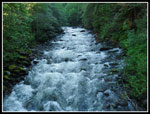
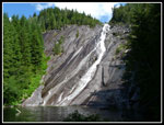
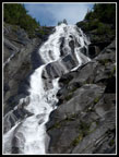
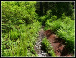
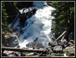
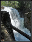
The next major landmark is Big Creek Falls. The old two lane concrete bridge there looks more and more out of place as the road narrows to trail. Big Creek Falls was really raging with snow melt. That is worth the effort alone. After Big Creek there is much more brush along the way. In some places the wet leaves can soak the hiker. For the most part it is narrow but still has room to get by and stay dry. The grade descends gently along here. It is about 5 miles to Big Creek and another 3/4 mile to the start of the trail to Snoqualmie Lake. On all my previous visits I went to the end of the road where the Nordrum Lake trail starts. This time I would be turning off the road a quarter mile before the end.
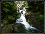
I met a couple of hikers at a creek crossing near the junction. Only the second party I had seen so far. Of most interest at the junction are the old signs. The one pointing to North Bend is from bygone automobile days. It is only 2 1/4 miles up to the lake gaining 1350'. After 5 3/4 miles of road/trail the net gain is only 600'. The gross gain with my wrong turn and Otter Falls visit was about 1000'. The trail up to the lake is in pretty good condition. It is muddy in places though recent work has been done to mitigate the muck. At one point the trail switchbacks right near another large waterfall. On the way back I scrambled over to get a partial view of it. There are a number more creek crossings and with care I made them all with dry feet.
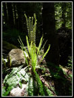
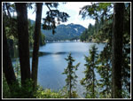
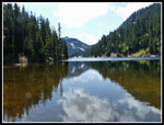
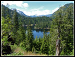
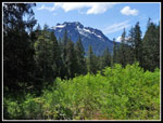
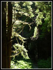
Higher up the deep forest gives way to some small meadows. Spring flowers were still blooming here. Some violets, bleeding hearts, and trillium. Spring in July. Just before the lake is a big loud waterfall. It starts right out of the lake outlet. Waterfalls were one of the hallmarks of the day. To my surprise the lake is completely melted out. Just some snow on the hillside above the far end of the lake. Campsites are bare and many are already dry. I found a rock jutting out into the water and stopped for a late lunch, I reached the lake at 12:27. Three hours and 15 minutes to cover about 8 1/2 miles, including my two side trips. Not a bad time at all.
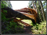
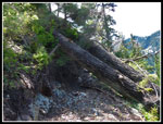
There are a few bugs at the lake though they are still slow and not much of a problem. Give it a week or two. On my visits via Lake Dorothy I dropped down to the lake and found a meadow on the shore to lay back and relax. I thought that the trail continued around the lake and then descended to Taylor River. With that in mind I decided to hike around the lake and then turn around. My GPS batteries were now about shot too. The trail begins with a short walk through grass and flowers then starts to ascend. It continues up and up. Going around the lake? Hmm... There were no sizable trees uncleared all the way to the lake. Beyond the outlet there are a bunch. About 15 or more trees from 12" to 36" in diameter. All are a pain to get over, under, or around. One fell on a bridge and crushed it. On several occasions I had to crawl on my hands and knees to get under.
The route continued up and began a series of short switchbacks. Had this not been a last minute decision I would have had a map plus my GPS batteries went from 3 bars to one in short order. The result is I did not figure out exactly where I was until I arrived home and looked at the GPS track on a map. In fact , I climbed 380' to within less than 10 minutes of Deer Lake. One full mile from the outlet. It just looked totally different arriving from the opposite direction. I've seen Deer Lake many times so it was not a disappointment, however I was so close I would have managed a few more downed trees had I realized I was almost there.
I hiked back to the outlet and then down the trail to the Taylor junction. I was very surprised to meet a total of 13 hikers coming up the trail. Only two groups had overnight gear. That is an awfully long day hike. Nice to see so many hikers putting in a lot of effort. The last 5 3/4 miles was very fast. I passed dozens of hikers going in and coming out. I left the lake at 1:56 and reached the car at 4:37. Only two hours and 41 minutes to cover eight miles.
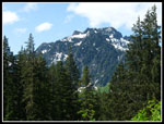
My last minute choice met my goals. Other than a few patches along the lake the trail was snow free. It was fast allowing me to get in a lot of miles and return home before fireworks traffic clogged up my route home. There were other people though an early start and long trip minimized that. The waterfalls were the stars of the day. Otter, Big Creek, the one along the Snoqualmie Lake trail, and the falls from the lake outlet were all big and loud. At 18.5 miles this was my longest hike since Mission Ridge - Devils Gulch last year. The trails were never steep but over that much distance it still added up to 2800' of elevation gain. Throw in sun and near 70 degrees and it was a great day for a hike.
Click on thumbnails to get
larger pictures.
Trips - 2012
Home
This trail has changed quite a bit in the 12 years since my last visit. After the first few miles the old road has narrowed to near trail size. There are now signs. First one for the Quartz Creek Road and also a huge cairn marking the turn off to Otter Falls. A new (to me) bridge is now at Marten Creek. The old automobile bridge has broken logs in places. It was removed and replaced with a narrow hiker bridge. Although the creeks were running fairly high I managed all the crossings with dry feet. Poles were helpful on the widest ones. It is very easy to make good time on the gentle grade. I averaged about 3.3 mph excluding a few stops.
I brought a GPS to record the distance and elevation change. Not at all necessary for navigation on this old road. I checked the GPS map at 2.73 miles and saw a trail shown just behind me. I backtracked a hundred feet and found the tread. I thought this must be the route to Otter Falls. Up I went on a steep and wet trail. As it neared a cascading creek on my right I realized that the Otter Falls trail is on the right of that creek. Oops! Zooming out the map showed that this was the trail to Marten Lake. I went up about an eighth of a mile before turning around. Well, at least I know where the trail is now. Once back on the trail I reached the bridge over Marten Creek in just a few minutes.
There are several creek crossings where the old road bed has been washed out. At one, there are two large culverts down the hill. In each case the creek crossing has been hacked farther into the hillside. No problems getting by. Next up was Otter Falls and Lipsy Lake. No problem finding the turn off now. A very large cairn made of rocks and blocks on the right and a smaller one on the left. The trail up is hard to follow as there are several paths. No matter, they all lead in short order to the falls. Plenty of water cascading down the rocks right now. Surprisingly, I was the only one there. I had a nice short break enjoying the sights.
The next major landmark is Big Creek Falls. The old two lane concrete bridge there looks more and more out of place as the road narrows to trail. Big Creek Falls was really raging with snow melt. That is worth the effort alone. After Big Creek there is much more brush along the way. In some places the wet leaves can soak the hiker. For the most part it is narrow but still has room to get by and stay dry. The grade descends gently along here. It is about 5 miles to Big Creek and another 3/4 mile to the start of the trail to Snoqualmie Lake. On all my previous visits I went to the end of the road where the Nordrum Lake trail starts. This time I would be turning off the road a quarter mile before the end.
I met a couple of hikers at a creek crossing near the junction. Only the second party I had seen so far. Of most interest at the junction are the old signs. The one pointing to North Bend is from bygone automobile days. It is only 2 1/4 miles up to the lake gaining 1350'. After 5 3/4 miles of road/trail the net gain is only 600'. The gross gain with my wrong turn and Otter Falls visit was about 1000'. The trail up to the lake is in pretty good condition. It is muddy in places though recent work has been done to mitigate the muck. At one point the trail switchbacks right near another large waterfall. On the way back I scrambled over to get a partial view of it. There are a number more creek crossings and with care I made them all with dry feet.
Higher up the deep forest gives way to some small meadows. Spring flowers were still blooming here. Some violets, bleeding hearts, and trillium. Spring in July. Just before the lake is a big loud waterfall. It starts right out of the lake outlet. Waterfalls were one of the hallmarks of the day. To my surprise the lake is completely melted out. Just some snow on the hillside above the far end of the lake. Campsites are bare and many are already dry. I found a rock jutting out into the water and stopped for a late lunch, I reached the lake at 12:27. Three hours and 15 minutes to cover about 8 1/2 miles, including my two side trips. Not a bad time at all.
There are a few bugs at the lake though they are still slow and not much of a problem. Give it a week or two. On my visits via Lake Dorothy I dropped down to the lake and found a meadow on the shore to lay back and relax. I thought that the trail continued around the lake and then descended to Taylor River. With that in mind I decided to hike around the lake and then turn around. My GPS batteries were now about shot too. The trail begins with a short walk through grass and flowers then starts to ascend. It continues up and up. Going around the lake? Hmm... There were no sizable trees uncleared all the way to the lake. Beyond the outlet there are a bunch. About 15 or more trees from 12" to 36" in diameter. All are a pain to get over, under, or around. One fell on a bridge and crushed it. On several occasions I had to crawl on my hands and knees to get under.
The route continued up and began a series of short switchbacks. Had this not been a last minute decision I would have had a map plus my GPS batteries went from 3 bars to one in short order. The result is I did not figure out exactly where I was until I arrived home and looked at the GPS track on a map. In fact , I climbed 380' to within less than 10 minutes of Deer Lake. One full mile from the outlet. It just looked totally different arriving from the opposite direction. I've seen Deer Lake many times so it was not a disappointment, however I was so close I would have managed a few more downed trees had I realized I was almost there.
I hiked back to the outlet and then down the trail to the Taylor junction. I was very surprised to meet a total of 13 hikers coming up the trail. Only two groups had overnight gear. That is an awfully long day hike. Nice to see so many hikers putting in a lot of effort. The last 5 3/4 miles was very fast. I passed dozens of hikers going in and coming out. I left the lake at 1:56 and reached the car at 4:37. Only two hours and 41 minutes to cover eight miles.
My last minute choice met my goals. Other than a few patches along the lake the trail was snow free. It was fast allowing me to get in a lot of miles and return home before fireworks traffic clogged up my route home. There were other people though an early start and long trip minimized that. The waterfalls were the stars of the day. Otter, Big Creek, the one along the Snoqualmie Lake trail, and the falls from the lake outlet were all big and loud. At 18.5 miles this was my longest hike since Mission Ridge - Devils Gulch last year. The trails were never steep but over that much distance it still added up to 2800' of elevation gain. Throw in sun and near 70 degrees and it was a great day for a hike.
 Trailhead |
 Taylor River |
 Old Road/Trail |
 Marten Creek Bridge |
 Marten Creek Cascades |
 Creek Wash Out |
 Otter Falls |
 Upper Falls |
 Waves In Falls |
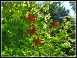 Columbine |
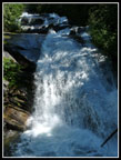 Big Creek Falls |
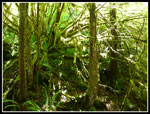 Lit Up Moss |
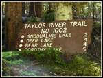 Old Trail Sign |
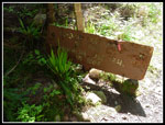 Older Trail Sign |
 Ferns |
 Bright Against Dark |
 No Underbrush |
 Creek Crossing |
 Green & Greener |
 Big Trees |
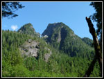
 Peak Above |
 Waterfall Below Lake |
 Falls Close Up |
 Snoqualmie Lake |
 Lake Reflection |
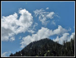 Clouds |
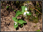 Trillium |
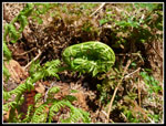 Unfurling Fern |
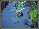 Frog |
 Broken Tree |
 Crawling Time |
 Lake Is Below |
 Crushed Bridge |
 Outlet Falls Again |
 Shades Of Green |
 Hidden Falls |
 Mossy Ground |
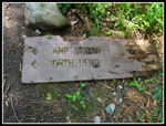 Oldest Sign |
 More Glowing Moss |
 View Across Taylor |
Trips - 2012
Home