12-29-12
I
had been planning this trip for several weeks. Since then there had
been several more snow storms in the mountains. I hoped that we would
be able to make the whole loop. The day before I found only about 3
inches of snow at Wallace Lake elevation on Tiger Mountain. I was
hopeful. Kim and Sarah joined me for this trip. It rained nearly all
the way to Wallace Falls State Park. Only a few cars in the lot as we
started out at 9:30 am. The rain had stopped too. It was just above
freezing. Cloudy enough that the viewpoint under the powerlines
provided
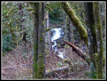
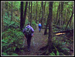
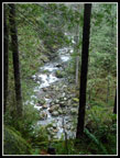
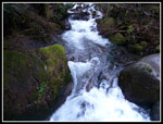
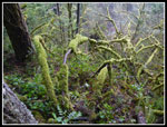
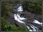
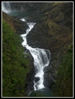
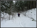
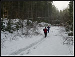
no views at all. We took the Woody Trail along the river. Plenty of
water in the side creeks and waterfalls. A number of ups and downs
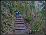
until we crossed the first branch of the Wallace River. From there it
was all uphill.
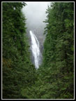
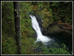
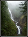
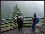
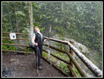
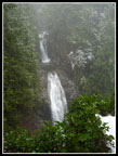
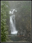
We took a short stop at the shelter site for views of the lower falls. The hanging clouds and fog added a moody feel to the waterfalls. The trail was not as muddy as I was expecting. So far we had seen a couple of groups going down already. When we reached bottom of the upper falls viewpoint there was suddenly heavy snow falling. In the forest we did not see it but at the viewpoint we had big flakes falling on us. I did not expect snow at only about 1500' elevation. We were soon heading on to the upper falls viewpoint. One group was already there. The snow was still falling very hard. The ground was brown but if looked like a winter snowstorm.
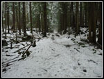
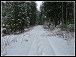
The route is not marked from the upper viewpoint but soon we were on the blue diamond route up to the upper old road. The very top is a built switchbacking trail. At the top there was a thin snow cover on the ground. Since we were only a few hundred feet below the lake it was looking good to get there without too much snow on the ground. We chose not to bring snowshoes so deep post holing would turn us around. I knew that part of the route to the lake is on a newer road with no tree cover. The snow would be deeper. How much? In all my years of taking the route to the lake I have seen only a few trees down blocking the way. This time was different.
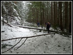
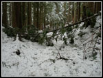
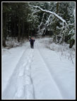
In the spring I did this loop and there were no trees down. Now there are dozens. clumps of three or four in one place. Single big trees. Branches closing off the gaps. Add in snow and it was slower going than hoped for. There are at least 20 - 30 trees that need to be sawed out. The snow was soon 4 - 6 inches deep. Not a big problem but it did slow us down. It was noon when we reached the road atop the falls. That left us 4.5 hours to hike the last 7 miles. We were doing fine the first half of the way to the lake. Then we popped out of the forest onto the newer road. The snow was instantly three to four feet deep. There were snowshoe tracks and deep post holes from multiple boots. On the positive side it was below freezing. The crust on top held our weight some of the time. Sometimes it did not. Our pace slowed way down.
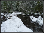
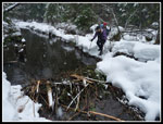
I had less trouble as my legs are much longer than Kim's and Sarah's. It was still snowing with no wind. If not for all the sinking in it was really beautiful. Finally we left the new road for the narrower old one that goes to the lake. We had only .40 miles to go. The mile on the newer road took us 1.5 hours. I kept a close watch on the amount of daylight we had left. The snow depth dropped dramatically back in the trees. Still some sinking but not up to our knees and beyond. Just a quarter mile from the lake is a small creek crossing. At least that's what I have seen on many previous visits. Not now. An industrious beaver has blacked the creek. Then we built a wall on one side. Then he built another wall on the other side. There is quite a lake now. The tracks we were following went across the real creek then along a narrow snow bank with weather on both sides to a dam built across the trail at the far side. The trail itself is now part of a lake that looked to be at least one to two feet deep.
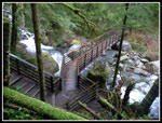
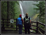
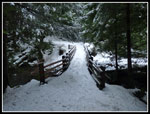
We crossed atop the beaver dam at the far end and were back on solid snow. A few minutes later we were at the bridge across the outlet of Wallace Lake. It was now 2:20 pm. Two hours until sunset with 4+ miles to go. We had not stopped for lunch and so had to do so now. The picnic tables had several feet of snow on top. By 2:35 pm we were heading down. The first road section is forested and the snow was not that deep. We made good time. The short section on the newer road had some post holing. There are several trees down across the road here too. We were glad to reach the top of the Greg Ball Trail. It has seen many more feet than the falls to lake route. There was a well packed trench. A little slick but no post holing. We stopped for Sarah to put on traction devices. A group passed us here. They had slogged up the newer road through deep snow. That was tough.
The trail down went fine. Within a mile the snow was gone. We made it to the bottom of the trail at 4:05 pm. Now we had the wide smooth railroad grade the rest of the way down. We covered the last 2.2 miles in one hour. It was almost pitch black at 5:05 back at the trailhead. This trip proved to be more word than I had envisioned. It ended up being a full day on the trail for 10 miles and 1700' of gain. It was also a blast. Big falling snowflakes. Long periods without seeing anyone else. Of course the waterfalls and the lake. A great next to last hike of the year.
Click on thumbnails to get
larger pictures.
Trips - 2012
Home
We took a short stop at the shelter site for views of the lower falls. The hanging clouds and fog added a moody feel to the waterfalls. The trail was not as muddy as I was expecting. So far we had seen a couple of groups going down already. When we reached bottom of the upper falls viewpoint there was suddenly heavy snow falling. In the forest we did not see it but at the viewpoint we had big flakes falling on us. I did not expect snow at only about 1500' elevation. We were soon heading on to the upper falls viewpoint. One group was already there. The snow was still falling very hard. The ground was brown but if looked like a winter snowstorm.
The route is not marked from the upper viewpoint but soon we were on the blue diamond route up to the upper old road. The very top is a built switchbacking trail. At the top there was a thin snow cover on the ground. Since we were only a few hundred feet below the lake it was looking good to get there without too much snow on the ground. We chose not to bring snowshoes so deep post holing would turn us around. I knew that part of the route to the lake is on a newer road with no tree cover. The snow would be deeper. How much? In all my years of taking the route to the lake I have seen only a few trees down blocking the way. This time was different.
In the spring I did this loop and there were no trees down. Now there are dozens. clumps of three or four in one place. Single big trees. Branches closing off the gaps. Add in snow and it was slower going than hoped for. There are at least 20 - 30 trees that need to be sawed out. The snow was soon 4 - 6 inches deep. Not a big problem but it did slow us down. It was noon when we reached the road atop the falls. That left us 4.5 hours to hike the last 7 miles. We were doing fine the first half of the way to the lake. Then we popped out of the forest onto the newer road. The snow was instantly three to four feet deep. There were snowshoe tracks and deep post holes from multiple boots. On the positive side it was below freezing. The crust on top held our weight some of the time. Sometimes it did not. Our pace slowed way down.
I had less trouble as my legs are much longer than Kim's and Sarah's. It was still snowing with no wind. If not for all the sinking in it was really beautiful. Finally we left the new road for the narrower old one that goes to the lake. We had only .40 miles to go. The mile on the newer road took us 1.5 hours. I kept a close watch on the amount of daylight we had left. The snow depth dropped dramatically back in the trees. Still some sinking but not up to our knees and beyond. Just a quarter mile from the lake is a small creek crossing. At least that's what I have seen on many previous visits. Not now. An industrious beaver has blacked the creek. Then we built a wall on one side. Then he built another wall on the other side. There is quite a lake now. The tracks we were following went across the real creek then along a narrow snow bank with weather on both sides to a dam built across the trail at the far side. The trail itself is now part of a lake that looked to be at least one to two feet deep.
We crossed atop the beaver dam at the far end and were back on solid snow. A few minutes later we were at the bridge across the outlet of Wallace Lake. It was now 2:20 pm. Two hours until sunset with 4+ miles to go. We had not stopped for lunch and so had to do so now. The picnic tables had several feet of snow on top. By 2:35 pm we were heading down. The first road section is forested and the snow was not that deep. We made good time. The short section on the newer road had some post holing. There are several trees down across the road here too. We were glad to reach the top of the Greg Ball Trail. It has seen many more feet than the falls to lake route. There was a well packed trench. A little slick but no post holing. We stopped for Sarah to put on traction devices. A group passed us here. They had slogged up the newer road through deep snow. That was tough.
The trail down went fine. Within a mile the snow was gone. We made it to the bottom of the trail at 4:05 pm. Now we had the wide smooth railroad grade the rest of the way down. We covered the last 2.2 miles in one hour. It was almost pitch black at 5:05 back at the trailhead. This trip proved to be more word than I had envisioned. It ended up being a full day on the trail for 10 miles and 1700' of gain. It was also a blast. Big falling snowflakes. Long periods without seeing anyone else. Of course the waterfalls and the lake. A great next to last hike of the year.
 Small Falls |
 Hiking Woody Trail |
 Above Wallace River |
 Bridge |
 River From Bridge |
 Steep Trail |
 Moss Everywhere |
 Middle Falls View |
 Lower Falls |
 Cascades |
 Middle Falls |
 Enjoying The View |
 White Water |
 Snowing Hard |
 Catching Snowflakes |
 Upper Falls |
 Snowy Falls |
 On Snowy Road/Trail |
 Trees Down |
 More Trees Down |
 Deeper Snow |
 Snowshoe Tracks |
 Slow Progress |
 Beaver Pond/Trail |
 Crossing Beaver Dam |
 Wallace Outlet Bridge |
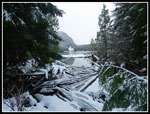 Wallace Lake |
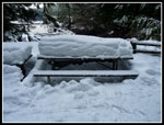 Snow Covered Tables |
 Top Of Greg Ball |
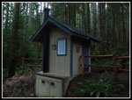 New Outhouse |
Trips - 2012
Home