9-30-12
At
the end of September I still had not had a good fall color hike.
Suzanne and company were heading to the far north and I joined in. I
hiked to Gold Run Pass in 1995. I finally made it to Yellow
Aster Butte in July 2006. The
new trail was built between my two visits. I had not been there in the
fall. It is a long drive from Seattle. We met at 7:15 am and
arrived at the crowded trailhead at 9:50 am. Folks were walking from
well below the last switchback though we found space for both cars
right at the switchback. There must have been 30 cars there before
10:00 am. This is not a hike to find much solitude. The distance and
elevation gain are moderate and the payoff is so high. It was 10:10 am
when we were on the trail. This can be a hot, dusty, and buggy
trailhead in the summer. No such problems this day.
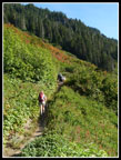
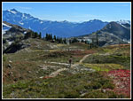
The trail is fairly narrow making it a challenge to pass a large party. Everyone was in a good mood and soon we were well between groups and on our own. After a few switchbacks in tall brush the way heads into forest for the next mile. After so many smoky trips the past month it was nice to have clean air once again. The big fires between Wenatchee and Ellensburg are still going but the wind was blowing to the east. The route climbs continuously though not very steeply. The forest thins and a few small meadows appear. I kept expecting to reach the junction but the route continues up towards Gold Run Pass.
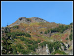
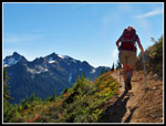
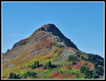
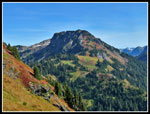
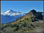
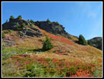
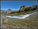
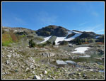
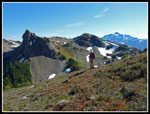
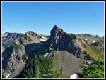
Views do open up to the backside of the three Yellow Aster bumps. On my first visit we climbed to the usual rounded summit. From there we descended to the ridge and followed a trail over to the higher pointed summit. A little scrambling but the trail leads to the top. On this trip the group planned to reach the third point, the one that is marked as Yellow Aster Butte on the USGS map. The most reasonable route is via the backside nearer to Gold Run Pass. At the junction we took the trail to the left. It contours around the basin and climbs up the slope. Part way around we parted company. I tweaked my knee on Kendall Peak a few weeks ago and chose not to do the scramble. Instead, Janet and I went ahead on the main trail. The scramble worked fine and the others reached the summit.
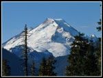
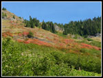
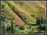
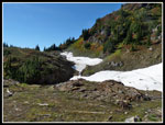
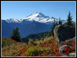
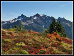
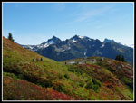
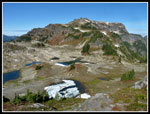
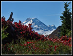
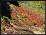
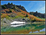
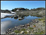
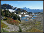
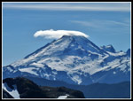
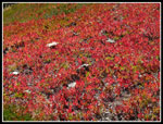
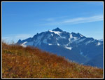
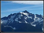
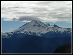
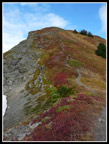
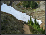
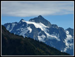
With lots of time at hand we took our time getting around to the tarns. The leaves were a little past prime but with enough backlighting they lit up very nicely. Dull leaves in one direction. Bright red, yellow, and orange in another. Although the forecast was for clouds to come in, the sky was crystal clear. The open slopes provide a great view south to Mt. Baker and Mt. Shuksan. There are still a couple snow patches. One will not come close to melting this year. No problems to cross therm. The route swings around the first Yellow Aster bump and soon the valley of the tarns comes into view. We could see a couple tents near the tarns.
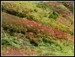
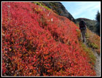
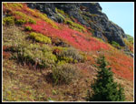
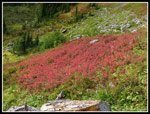
Our route came to an unsigned junction. It's a steep 400' straight uphill to the first summit. We chose to descend instead to the upper tarns. On my first visit we hit two summits and I kept looking over to the ridge of Tomyhoi Peak. It climbs steeply then more gradually through meadowed park land. I was much more interested in exploring that than going back up to the summits. In fact, there was no time all day that I did not see at least half a dozen hikers on the rounded summit. The steep switchbacked slope down to the tarns had the brightest red leaves of the day. Down at the first tarn I saw it was already 12:30 and time for lunch.
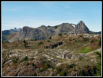
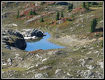
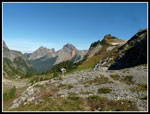
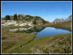
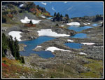
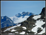
After food and water it was time to visit the other tarns and head up the Tomyhoi ridge. One tarn is still largely ice covered at the end of September. The route up the ridge is very steep at the bottom. After a few hundred feet it crests the top and gentle meadows commence. A really fantastic place. Based on the crowds a whole lot of folks already know this. We climbed higher until we had a look down to Tomyhoi Lake. It is a big lake. I was surprised to see that one end is all mud. The lake level is very low. We could now see the YAB named on the map. Our folks were long gone as the summit was unoccupied. The views were tremendous from our turn around spot. We spent at least a half hour there. At 2:00 pm we reluctantly headed back. There were a number of bright red leave patches to enjoy coming down.
I was a bit afraid of hurting my knee again on the steep loose section but had no problem. Janet has had two knees replaced and she did just fine too. As we circled the tarns we met Darryl from our group. Seems the rest had climbed up the rounded YAB bump. We headed up to the junction with that route. Darryl and I decided to climb up to that vantage point. Janet enjoyed the views from below. When we reached the top the others were nowhere to be found. There aren't a lot of ways down. A glance down the ridge to the highest summit showed a group on top. I had had enough climbing but Daryll headed down to the ridge and over to the other summit.
When the others finally started back I headed on down. I expected them to catch up but they never did. I had a nice solo hike back to the trailhead. Lots more to photograph and much different lighting than in the morning. I took my time and enjoyed the hike down. I finally reached the trailhead at 5:00 pm. The others arrived about fifteen minutes later. As has happened on several occasions, I saw Nancy and Mark. They finished just ahead of me. It is a small world. It's also a long drive home. We stopped for dinner in Mt. Vernon and so it was 9:30 pm by the time I arrived home.
This was a very good fall trip. Lots of time above tree level with views for many miles. The colors were not quite at their peak but were still very good. I expected crowds and they really did not detract from the day. Just lots of happy people enjoying the mountains. This is a fun trip in early summer when the flowers are blooming. There is a lot to be said for little snow, no bugs, and fall colors too. I plan to return in a not too distant September.
Click on thumbnails to get
larger pictures.
Trips - 2012
Home
The trail is fairly narrow making it a challenge to pass a large party. Everyone was in a good mood and soon we were well between groups and on our own. After a few switchbacks in tall brush the way heads into forest for the next mile. After so many smoky trips the past month it was nice to have clean air once again. The big fires between Wenatchee and Ellensburg are still going but the wind was blowing to the east. The route climbs continuously though not very steeply. The forest thins and a few small meadows appear. I kept expecting to reach the junction but the route continues up towards Gold Run Pass.
Views do open up to the backside of the three Yellow Aster bumps. On my first visit we climbed to the usual rounded summit. From there we descended to the ridge and followed a trail over to the higher pointed summit. A little scrambling but the trail leads to the top. On this trip the group planned to reach the third point, the one that is marked as Yellow Aster Butte on the USGS map. The most reasonable route is via the backside nearer to Gold Run Pass. At the junction we took the trail to the left. It contours around the basin and climbs up the slope. Part way around we parted company. I tweaked my knee on Kendall Peak a few weeks ago and chose not to do the scramble. Instead, Janet and I went ahead on the main trail. The scramble worked fine and the others reached the summit.
With lots of time at hand we took our time getting around to the tarns. The leaves were a little past prime but with enough backlighting they lit up very nicely. Dull leaves in one direction. Bright red, yellow, and orange in another. Although the forecast was for clouds to come in, the sky was crystal clear. The open slopes provide a great view south to Mt. Baker and Mt. Shuksan. There are still a couple snow patches. One will not come close to melting this year. No problems to cross therm. The route swings around the first Yellow Aster bump and soon the valley of the tarns comes into view. We could see a couple tents near the tarns.
Our route came to an unsigned junction. It's a steep 400' straight uphill to the first summit. We chose to descend instead to the upper tarns. On my first visit we hit two summits and I kept looking over to the ridge of Tomyhoi Peak. It climbs steeply then more gradually through meadowed park land. I was much more interested in exploring that than going back up to the summits. In fact, there was no time all day that I did not see at least half a dozen hikers on the rounded summit. The steep switchbacked slope down to the tarns had the brightest red leaves of the day. Down at the first tarn I saw it was already 12:30 and time for lunch.
After food and water it was time to visit the other tarns and head up the Tomyhoi ridge. One tarn is still largely ice covered at the end of September. The route up the ridge is very steep at the bottom. After a few hundred feet it crests the top and gentle meadows commence. A really fantastic place. Based on the crowds a whole lot of folks already know this. We climbed higher until we had a look down to Tomyhoi Lake. It is a big lake. I was surprised to see that one end is all mud. The lake level is very low. We could now see the YAB named on the map. Our folks were long gone as the summit was unoccupied. The views were tremendous from our turn around spot. We spent at least a half hour there. At 2:00 pm we reluctantly headed back. There were a number of bright red leave patches to enjoy coming down.
I was a bit afraid of hurting my knee again on the steep loose section but had no problem. Janet has had two knees replaced and she did just fine too. As we circled the tarns we met Darryl from our group. Seems the rest had climbed up the rounded YAB bump. We headed up to the junction with that route. Darryl and I decided to climb up to that vantage point. Janet enjoyed the views from below. When we reached the top the others were nowhere to be found. There aren't a lot of ways down. A glance down the ridge to the highest summit showed a group on top. I had had enough climbing but Daryll headed down to the ridge and over to the other summit.
When the others finally started back I headed on down. I expected them to catch up but they never did. I had a nice solo hike back to the trailhead. Lots more to photograph and much different lighting than in the morning. I took my time and enjoyed the hike down. I finally reached the trailhead at 5:00 pm. The others arrived about fifteen minutes later. As has happened on several occasions, I saw Nancy and Mark. They finished just ahead of me. It is a small world. It's also a long drive home. We stopped for dinner in Mt. Vernon and so it was 9:30 pm by the time I arrived home.
This was a very good fall trip. Lots of time above tree level with views for many miles. The colors were not quite at their peak but were still very good. I expected crowds and they really did not detract from the day. Just lots of happy people enjoying the mountains. This is a fun trip in early summer when the flowers are blooming. There is a lot to be said for little snow, no bugs, and fall colors too. I plan to return in a not too distant September.
 Mt. Baker |
 First Color |
 Brush Along Trail |
 Views Up To YAB |
 Trail Through Color |
 Snow Crossings |
 Janet On Trail |
 Thistles |
 Baker & Color |
 Towards Welcome Pass |
 Alpine Terrain |
 Colorful But Muted |
 Towards Gold Run Pass |
 Color & Mt. Shuksan |
 Many Colors |
 Lower Tarn |
 Ice and Fall Colors |
 Tarns & Tomyhoi |
 Border Peaks |
 Framed Baker |
 Trail Down To Tarns |
 Great Color! |
 Tarn Reflection |
 Great Scenery |
 Green Water |
 Reds & Yellows |
 Still Ice Covered |
 Last Tarn |
 Popular Summit |
 Up Tomyhoi Ridge |
 Admiring The View |
 Lenticular Cloud |
 Two YAB Summits |
 Tomyhoi Meadows |
 Leaves On Fire |
 View Of Tarns |
 Grass & Shuksan |
 Canadian Peaks |
 Glacier To The East |
 Shuksan Close Up |
 Clouds Rolled In |
 Heading To Summit |
 Hiker Crossing Snow |
 Monkeyflower |
 Shuksan Again |
 Last Color Shot |
 Big Lenticular |
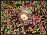
 Looks Like Cotton |
Trips - 2012
Home