4-20-13
On
the west side of the mountains I have seen some blooming trillium,
violets, and skunk cabbage this spring. On the east side the real
spring wildflower show is underway. Gwen planned another visit to Sauer
Mountain near Leavenworth and I went along. We met in Monroe at the
civilized hour of 7:45 am and headed east. It rained much of the way
across Stevens Pass. Things improved as we neared Leavenworth. We went
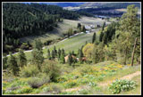
into Peshastin, back to Anderson Canyon and up to the trailhead. The
start is on private land and much thanks goes to the Sauer family for
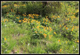
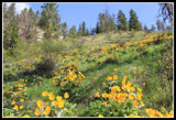
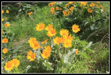
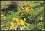
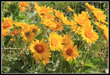
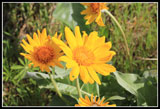
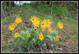
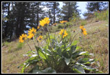
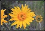
providing this trail. Lots of balsamroot in bloom from the start. The
blue sky and flowers made the long drive well worthwhile. It was just
after 9:30 when we headed out.
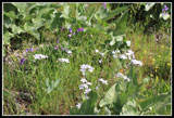
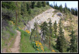
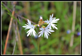
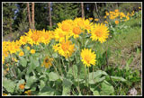
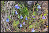
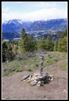
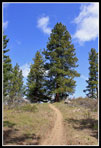
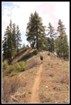
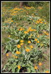
The first bit of trail has many of the Sauer's carved totems, faces on trees, and the like. The balsamroot was at or just past peak near the start. It is going strong higher up. The trail is very narrow and the hillside quite steep so getting around other hikers takes a little care. The trail itself climbs at a steady grade. There was a little lupine in bloom but the vast majority is still a week or two away. Lots of small flowers whose names I could not recall. There were a lot of bluebells and some yellow bells higher up. The phlox had very large flowers. The afternoon forecast was for winds up to 30 mph and I was pleased to find it very light in the morning. Not so easy to photograph flowers blowing in the wind.
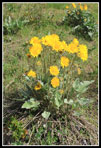
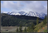
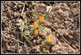
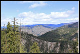
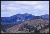
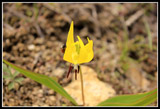
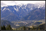
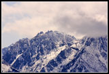
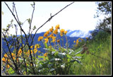
We were taking our time and we let several other groups pass on by. As we ascended we could see the far eastern end of the Stuart Range area peaks. Much of it was lost in clouds farther west. At the junction Gwen suggested going left on the trail to the viewpoint. From there we had even better views of the peaks and out to the Wenatchee River Valley. Icicle Ridge was right in front of us and to the west we could see rain. None for us this day. The trail leaves the viewpoint on the ridge top. We stayed on the ridge all the way to our turn around point. Now higher in forest we began to see blooming glacier lilies. Nearby were lots of spring beauty. Also more bluebells and yellow bells here.
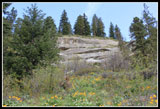
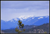
The ridge top is seldom flat. Up and down we went as we slowly worked our way higher. There are half mile markers along the main trail allowing you to see where you are. The trail crosses into National Forest land and later crosses an old road. There are notices on trees denoting a timber cut. I sure hope the trail is not wrecked by a cut. Judging by the stumps it was logged years ago and the trees are mostly not that big. After about a dozen false summits a steep climb brought us to the sign for Sauer Mountain. Pretty good views out from there. A wooden sign shows that Rock, Clark, Glacier Peak, and many other summits are visible on a clear day. We did not have clear sky to the west but it was blue over head. We went a little farther going up then down then up to a spot out of the wind for lunch. At our slow photo pace it was already 12:20 pm. It is about 2.5 miles to the top.
After lunch we continued on the ridge top trail. The Sauer Mountain sign and summit register is not the end of the trail. More ups and downs including a higher high point and then we started heading down. The trail on private land is way too narrow for wheels and they are not allowed. Farther along we did see tire tracks. We also met some motorcyclers near our turn around point. They were courteous as I seem to always find on east side trails. We stopped where the trail spit. One dropped steeply to our left. The other dropped steeply in front of us. From the map the main trail drops to a maintained road and continues. One trip report showed a 10.5 mile one way trip. We had no desire to drop off the ridge into the canyon below and then climb back up.
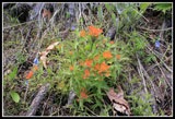
We added a little over a mile of ridge walking beyond the summit sign where most folks seem to stop. That brought the total distance to a bit over 7 miles. Its about 1800' gross gain to the top but all the ups and downs and our extra mile brought it to somewhere around 2200' I did not bring a GPS for this trip. The trip back was pleasant though the wind did pick up. it was sunny so we stayed with short sleeves. At the junction we took the left and main trail creating a loop. Along here we saw many more balsamroot. To our surprise we also saw blooming Indian paintbrush. I did not expect it to be out so early.
It was 4:10 pm by the time we reached the trailhead. We packed a full day into 7 miles. I was in no hurry to get back to the rain and clouds to the west. I always look forward to several wildflower hikes on the east side of the mountains in the spring time. This trail is one I will come back to in the future. A lot of bang for the buck and effort. It may be only April but the flower show is well on its way. On the drive back it rained most of the way. I always enjoy escaping the rain even for just a day.
Click on thumbnails to get
larger pictures.
Trips - 2013
Home
The first bit of trail has many of the Sauer's carved totems, faces on trees, and the like. The balsamroot was at or just past peak near the start. It is going strong higher up. The trail is very narrow and the hillside quite steep so getting around other hikers takes a little care. The trail itself climbs at a steady grade. There was a little lupine in bloom but the vast majority is still a week or two away. Lots of small flowers whose names I could not recall. There were a lot of bluebells and some yellow bells higher up. The phlox had very large flowers. The afternoon forecast was for winds up to 30 mph and I was pleased to find it very light in the morning. Not so easy to photograph flowers blowing in the wind.
We were taking our time and we let several other groups pass on by. As we ascended we could see the far eastern end of the Stuart Range area peaks. Much of it was lost in clouds farther west. At the junction Gwen suggested going left on the trail to the viewpoint. From there we had even better views of the peaks and out to the Wenatchee River Valley. Icicle Ridge was right in front of us and to the west we could see rain. None for us this day. The trail leaves the viewpoint on the ridge top. We stayed on the ridge all the way to our turn around point. Now higher in forest we began to see blooming glacier lilies. Nearby were lots of spring beauty. Also more bluebells and yellow bells here.
The ridge top is seldom flat. Up and down we went as we slowly worked our way higher. There are half mile markers along the main trail allowing you to see where you are. The trail crosses into National Forest land and later crosses an old road. There are notices on trees denoting a timber cut. I sure hope the trail is not wrecked by a cut. Judging by the stumps it was logged years ago and the trees are mostly not that big. After about a dozen false summits a steep climb brought us to the sign for Sauer Mountain. Pretty good views out from there. A wooden sign shows that Rock, Clark, Glacier Peak, and many other summits are visible on a clear day. We did not have clear sky to the west but it was blue over head. We went a little farther going up then down then up to a spot out of the wind for lunch. At our slow photo pace it was already 12:20 pm. It is about 2.5 miles to the top.
After lunch we continued on the ridge top trail. The Sauer Mountain sign and summit register is not the end of the trail. More ups and downs including a higher high point and then we started heading down. The trail on private land is way too narrow for wheels and they are not allowed. Farther along we did see tire tracks. We also met some motorcyclers near our turn around point. They were courteous as I seem to always find on east side trails. We stopped where the trail spit. One dropped steeply to our left. The other dropped steeply in front of us. From the map the main trail drops to a maintained road and continues. One trip report showed a 10.5 mile one way trip. We had no desire to drop off the ridge into the canyon below and then climb back up.
We added a little over a mile of ridge walking beyond the summit sign where most folks seem to stop. That brought the total distance to a bit over 7 miles. Its about 1800' gross gain to the top but all the ups and downs and our extra mile brought it to somewhere around 2200' I did not bring a GPS for this trip. The trip back was pleasant though the wind did pick up. it was sunny so we stayed with short sleeves. At the junction we took the left and main trail creating a loop. Along here we saw many more balsamroot. To our surprise we also saw blooming Indian paintbrush. I did not expect it to be out so early.
It was 4:10 pm by the time we reached the trailhead. We packed a full day into 7 miles. I was in no hurry to get back to the rain and clouds to the west. I always look forward to several wildflower hikes on the east side of the mountains in the spring time. This trail is one I will come back to in the future. A lot of bang for the buck and effort. It may be only April but the flower show is well on its way. On the drive back it rained most of the way. I always enjoy escaping the rain even for just a day.
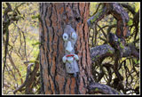 Tree Art |
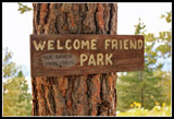
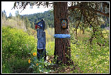 Welcome To Sauer Mt. |
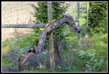 Wolf |
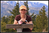
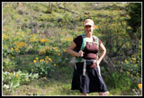 Gwen |
 Blooming Balsamroot |
 Yellow Hillside |
 At Their Peak |
 Good Color |
 Close Up |
 Closer Still |
 Sandstone Cliffs |
 Bouquet |
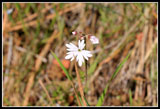 Prairie Star |
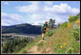 Gwen On Narrow Trail |
 Plox & Purple Flower |
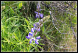 Lupine |
 Anderson Canyon |
 Snowy Peaks |
 Trail Above Cliffs |
 More Prairie Stars |
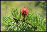 Tree Flower? |
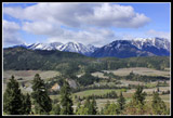 Icicle Ridge |
 Balsamroot At Viewpoint |
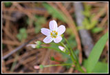 Spring Beauty |
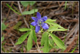 Oregon Anemone |
 Narrow Petals |
 Bluebells |
 Yellow Bells |
 Sauer Mt.Summit |
 More Uphill |
 View North |
 View Northwest |
 More High Clouds |
 Ridge Top Trail |
 Bug On Glacier Lily |
 Leavenworth |
 McClellan Peak |
 Gwen At Summit |
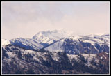 Snowy Cloudy Peak |
 Welcome Friend Park |
 Back Lit Balsamroot |
 Indian Paintbrush |
 Another Big Bloom |
 Sun Lit |
 Awash In Yellow |
Trips - 2013
Home