5-25-14
On
Saturday, I did a hike on the east side of the Cascades with Janet.
Sunday I joined Gwen for one on the west side. since the entire state
would be under clouds we chose a shorter trip where summit views were
not the draw. I had never hiked on the Deception Creek Trail or even
stopped at Deception Falls which is right off the Highway. Time for
something new. The Doppler radar showed the main rainy spot in the
state was between Skykomish and Stevens Pass. Yep, that's were we were
headed. We met in Bothell and headed east. As we passed Skykomish the
pavement was dry. Huh? I guess I should not always believe the radar
map. It was bone dry when we arrived at the trailhead. It is less than
half a mile off Highway 2 just beyond the Deception Falls parking lot.
There was one truck in the 2000' elevation parking lot. We arrived at
9:40 am and were on the trail before 10:00 am. No early bird start this
day.
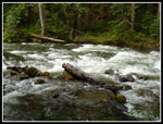
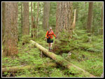
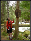
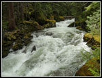
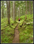
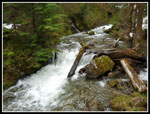
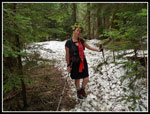
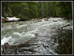
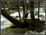
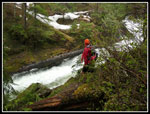
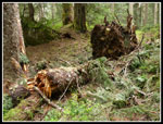
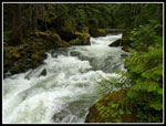
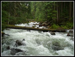
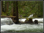
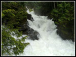
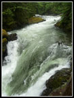
This hike is all about the trees and the creek. There are no views out to mountains are anything else. That does not make this a boring trail. At least not to me. The trail drops quickly to Deception Creek. If may be a trickle in late summer but it is a wild raging torrent at this time of year. Lots of snow melt has the river running high. It is a continuously roiling froth of white water. In several places early on the trail is under water. It is easy to detour around. Some big cedar trees were islands with water roaring around the trunks. The water was several feet higher than normal. In short order we entered the Alpine Lakes Wilderness. No more stumps. Lots of very big trees. I did not see any 9 foot wide trees on this hike. I did see countless 4-7 foot wide trees. A great example of easy to access old growth forest.
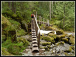
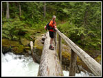
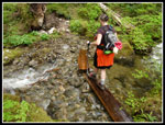
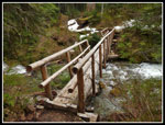
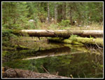
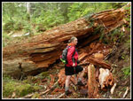
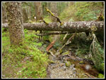
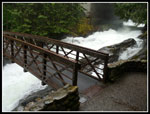
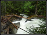
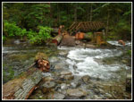
The first part had the unmistakable aroma of skunk cabbage. They are at or just beyond their peak. Farther along we saw many more. Trillium were also blooming in abundance along with yellow violets. Within half a mile we reached the bridge over Deception Creek. It is quite an engineering wonder. Steps lead high up to the log bridge. Handrails provide support as the sight and sound of the crashing white water is impressive as we crossed. Now on the west side of the creek the trail begins to climb away from the creek. It is out of sight for several miles though it can always be heard. The trail is very narrow and lends a more isolated feel to the route. I liked it. we soon came upon blow downs. There are half a dozen good sized ones that require climbing over, around, or through. We spent some time on the way out and cleared several of them of piles of branches. Lots of small creek crossings. A few had logs placed. None were a problem.
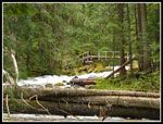
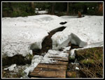
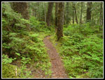
The trail climbs consistently for a mile. Not overly steep but at a steady grade. This is one green trail. Big trees, green brush, and lots of moss. We saw acres of devils club that is just now leafing out. From the 3200' high point the trail begins to descend. We crossed Sawyer Creek on a log bridge. A section of the handrail on one side is gone. This side creek was huge. As we neared the creek there were were some open spots and the lack of trees meant deeper snow and some still lingering. The trail was buried on and off but not hard to follow. We met one couple who were coming back. The campsite at 3 miles is under snow. I never saw it though there is a good sized flat area as we reached Deception Creek once again.
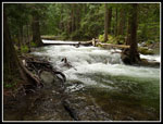
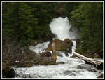
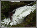
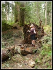
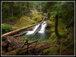
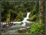
We left the trail and went over to the creek. Forget about finding any gravel bars this time of year. The creek went right up to the forest. Gwen had hiked this trail once before at low water and it was like a brand new hike for her. Much more water than before. We sat and had lunch at a very wide spot. So wide that it looked like one could possibly even ford the creek here. Not that I would want to cross 100' feet of icy water. With all the snow we contemplated turning around. Gwen noticed moving white between the trees in the distance. It sure looked like a waterfall. We packed up and headed up along the creek. The creek made a turn and we went far enough to see around it. There was one very loud waterfall. The creek squeezed down in a narrow chasm and the water roared through. We climbed back up the slope and found the now bare trail. In short order the trail took us to the great views of the falls. It was several continuous falls in the narrow chasm. The noise and blowing mist was very impressive. We found some very good viewpoints.
A single hiker with a dog caught up with us here He kept going. At the top of the cascading falls we stopped. It was time to head back. On the return we did trail work as mentioned. In several spots we were able to reopen the trail. A few spots will require a crew to saw through the big trees. We met one more group of two guys heading up. That was it for the day. Yet another hike with a whole lot of solitude. Part way back the rain finally arrived. It was steady but light. I had on a jacket but never did pull out my umbrella. If you are going to do a river (creek) walk this is the time to do it. The water was high and loud and put on quite a show. The trees were bigger than the second growth I usually see. A great hike without a day trip destination.
Back at the car we drove back to the highway and quickly left it for the Deception Falls parking lot. It was closed just two weeks ago but is open now. We put our rain jackets back on, left the packs and headed out for the half mile loop trial. First we went to the falls. It is not very far from the lot. The trail drops then heads for the creek. The upper falls is partly under the highway. A walkway goes under the road. The mist was so bad it was hard to get a photo. Very impressive during high snow melt times.
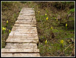
We went on to the loop and quickly found that a side channel of the creek currently blocks the trail. There is no bridge and the water is more than knee deep and running fast. We went back and did the loop in the other direction. Lots of sign boards with information about the creek and the forest. A good interpretive site. A bridge took us across the side channel and around to the point of no bridge. We headed back and turned a half mile loop into a one mile out and back. There were a number of folks walking around in the rain. Back at the car we changed into dry clothes and headed for home. The rain did not seem to have sent holiday weekend campers home early as we had light traffic. This was a surprisingly good hike. A lot of fast and loud water, a big popular falls and a big not popular falls along with good company made for a great day on the trail.
Click on thumbnails to get
larger pictures.
Trips - 2014
Home
This hike is all about the trees and the creek. There are no views out to mountains are anything else. That does not make this a boring trail. At least not to me. The trail drops quickly to Deception Creek. If may be a trickle in late summer but it is a wild raging torrent at this time of year. Lots of snow melt has the river running high. It is a continuously roiling froth of white water. In several places early on the trail is under water. It is easy to detour around. Some big cedar trees were islands with water roaring around the trunks. The water was several feet higher than normal. In short order we entered the Alpine Lakes Wilderness. No more stumps. Lots of very big trees. I did not see any 9 foot wide trees on this hike. I did see countless 4-7 foot wide trees. A great example of easy to access old growth forest.
The first part had the unmistakable aroma of skunk cabbage. They are at or just beyond their peak. Farther along we saw many more. Trillium were also blooming in abundance along with yellow violets. Within half a mile we reached the bridge over Deception Creek. It is quite an engineering wonder. Steps lead high up to the log bridge. Handrails provide support as the sight and sound of the crashing white water is impressive as we crossed. Now on the west side of the creek the trail begins to climb away from the creek. It is out of sight for several miles though it can always be heard. The trail is very narrow and lends a more isolated feel to the route. I liked it. we soon came upon blow downs. There are half a dozen good sized ones that require climbing over, around, or through. We spent some time on the way out and cleared several of them of piles of branches. Lots of small creek crossings. A few had logs placed. None were a problem.
The trail climbs consistently for a mile. Not overly steep but at a steady grade. This is one green trail. Big trees, green brush, and lots of moss. We saw acres of devils club that is just now leafing out. From the 3200' high point the trail begins to descend. We crossed Sawyer Creek on a log bridge. A section of the handrail on one side is gone. This side creek was huge. As we neared the creek there were were some open spots and the lack of trees meant deeper snow and some still lingering. The trail was buried on and off but not hard to follow. We met one couple who were coming back. The campsite at 3 miles is under snow. I never saw it though there is a good sized flat area as we reached Deception Creek once again.
We left the trail and went over to the creek. Forget about finding any gravel bars this time of year. The creek went right up to the forest. Gwen had hiked this trail once before at low water and it was like a brand new hike for her. Much more water than before. We sat and had lunch at a very wide spot. So wide that it looked like one could possibly even ford the creek here. Not that I would want to cross 100' feet of icy water. With all the snow we contemplated turning around. Gwen noticed moving white between the trees in the distance. It sure looked like a waterfall. We packed up and headed up along the creek. The creek made a turn and we went far enough to see around it. There was one very loud waterfall. The creek squeezed down in a narrow chasm and the water roared through. We climbed back up the slope and found the now bare trail. In short order the trail took us to the great views of the falls. It was several continuous falls in the narrow chasm. The noise and blowing mist was very impressive. We found some very good viewpoints.
A single hiker with a dog caught up with us here He kept going. At the top of the cascading falls we stopped. It was time to head back. On the return we did trail work as mentioned. In several spots we were able to reopen the trail. A few spots will require a crew to saw through the big trees. We met one more group of two guys heading up. That was it for the day. Yet another hike with a whole lot of solitude. Part way back the rain finally arrived. It was steady but light. I had on a jacket but never did pull out my umbrella. If you are going to do a river (creek) walk this is the time to do it. The water was high and loud and put on quite a show. The trees were bigger than the second growth I usually see. A great hike without a day trip destination.
Back at the car we drove back to the highway and quickly left it for the Deception Falls parking lot. It was closed just two weeks ago but is open now. We put our rain jackets back on, left the packs and headed out for the half mile loop trial. First we went to the falls. It is not very far from the lot. The trail drops then heads for the creek. The upper falls is partly under the highway. A walkway goes under the road. The mist was so bad it was hard to get a photo. Very impressive during high snow melt times.
We went on to the loop and quickly found that a side channel of the creek currently blocks the trail. There is no bridge and the water is more than knee deep and running fast. We went back and did the loop in the other direction. Lots of sign boards with information about the creek and the forest. A good interpretive site. A bridge took us across the side channel and around to the point of no bridge. We headed back and turned a half mile loop into a one mile out and back. There were a number of folks walking around in the rain. Back at the car we changed into dry clothes and headed for home. The rain did not seem to have sent holiday weekend campers home early as we had light traffic. This was a surprisingly good hike. A lot of fast and loud water, a big popular falls and a big not popular falls along with good company made for a great day on the trail.
 Deception Creek |
 Gwen On Detour |
 White Water Creek |
 Bridge Is In Sight |
 Wilderness Sign |
 Log Steps |
 Gwen On Bridge |
 Roaring Creek |
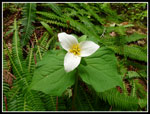 Trillium |
 Green Forest |
 Crossing Side Creek |
 Marsh Marigolds |
 Sawyer Creek Bridge |
 Sawyer Creek |
 Bog Orchids |
 Suddenly On Snow |
 Mountain Nymph |
 Lunch Spot |
 Bottom Of Falls |
 Viewing Spot |
 Above The Torrent |
 Narrow & Fast |
 Reflection |
 Big Blocking Tree |
 Before |
 After |
 Toughest Blockage |
 More Green Forest |
 More White Water |
 Near The End |
 Trees In The Creek |
 Deception Falls |
 Upper Falls |
 Right Turn |
 Right By Creek |
 Not A Loop |
 Small Falls |
 Last Waterfall |
Trips - 2014
Home