1-25-15
I
have hiked up Mt Teneriffe a
number of times since my first visit in 1994. At first the road was the
only way. There was just a short description on Footsore 2 to go by.
Later I heard about the direct ridge route though it took several more
years to find the start and more years before I hiked it. The road
route was long but not too awfully steep. The boot path from the road
end saddle to the summit was a faint route to the top. Today the
situation is much different. The ridge route via Kamikaze Falls is very
short and steep. More folks have heard about the mountain. Total
solitude is much less often achieved.
When I heard that the road had been converted to a trail I had to check it out. It had almost nine years since I went up via the road route. Last weekend I cross country skied east of Stevens Pass on Smith Brook Road starting at 3200'. On Wednesday we hiked to Grand Prospect on Rattlesnake Mountain at over 3000' and had no snow at all. There were no recent reports on Teneriffe. to be safe I took heavier boots, an ice axe, and microspikes. It turned out to be serious overkill. Light trail runners on my feet would have been fine. There was very little snow to be seen. None at the 4788' summit. This is late January?
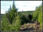
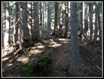
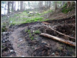
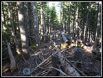
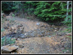
I arrived at the Teneriffe Road trailhead at 7:50 am. There were four other cards in the small lot. It was already in the low 50s. The high was to be around 60 degrees. The road up to the turn off for the falls is unchanged. Still the same wide road. The turn is signed for the falls but there is no sign for the road route to the summit. At about 1.5 miles the flats are left and the climbing begins. This is where the road to trail conversion starts. All the culverts have been pulled. About half the width of the road has been dug up. It does feel a lot more trail like. Unlike the Granite Creek Road conversion, this one does not weave back and forth from road edge to edge. It is straight. Considering the length of the route I'm glad it was not made longer with all the twists and turns of the Granite route.
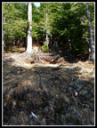
There is only one negative. Digging up the road unearthed several thousand small rocks. Many now lie on the trail. I took time to kick off several hundred baseball to softball sized rocks. If enough other hikers do the same it will be much better. Going up is fine. The problem is slipping on the many rocks when coming down. I was careful and still had a few slips. Remove enough rocks and the route can be much better than it was as a road. Definitely not as hard as the long hard roadbed used to be.
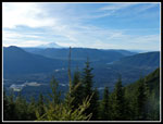
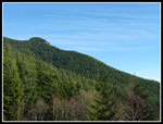
By 9:00 am it was hot enough to have me sweating (in January?). Blue sky and very little wind. The long switchbacks went by and I had a good view from just above the last leftward switchback. Mailbox Peak, Mt Washington, the SF Snoqualmie Valley, and over to Rattlesnake Mountain. At the flat area two culverts were pulled and now there are two creeks to cross. Lots of water but easy to step across. I took a short water break at the Mt. Si junction and headed higher. The traverse over to the road end at the saddle was mostly in the open in 1994. Views out the whole way. Now the forest has grown up and there are only a couple places with views. There is also shade now instead of it all being out in the sun. As I climbed I looked back to see the Haystack summit of Mt Si. Ahead I had a couple views over to the summit of Mt. Teneriffe. It was still several miles away.
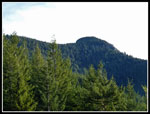
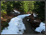
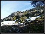
As the road reached a high point and began to descend I found the first snow of the day. The road was mostly snow covered for about five minutes of walking. That was it for the day. Soon the road was bare once again. The old cabin site is still visible but only if you knew it was there. I reached the road end saddle and took a short break. The old boot path climbed steeply to the ridge top and followed it along the ridge, down to a saddle and then steeply up to the top of Teneriffe. Now there is a built trail climbing gently from the saddle well below the ridge. It switches back several times coming closer to the ridge top. The grade is very gentle.
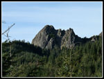
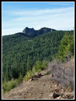
After three or four switchbacks the ridge top is reached about 2/3s of the way along. The new trail disappears and the old boot path continues. Up over the high point and down to the saddle it still goes. A few small trees have been removed to make the hiking easier. At the saddle the track is still a little hard to follow as the route begins to climb. Then built trail starts up again. I expected numerous short switchbacks would climb along the same route as the old trail. It does not. Instead, there are a number of switchbacks then the route traverses under the summit to the far ridge. Where it meets the Kamikaze Ridge route it ends and the ridge path continues on to the summit some 75' above. I met a hiker coming down the road road just below the top. The first person I saw all day. Two others were on top. They came up the ridge and were going down the road/trail via Mt. Si.
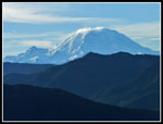
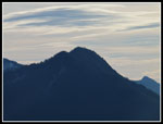
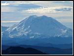
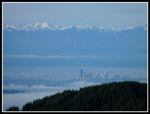
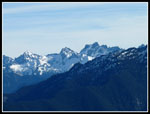
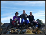
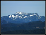
I arrived on top at 11:20 am. Beautiful views north to Mt. Baker and south to Mt. Rainier. Both peaks line up with the summit ridge. As mentioned earlier, the whole ridge trail to the top was snow free except for about 8' of trail. Not a drop of snow on the summit ( January right?). I had a long stay on top before more folks started to arrive. Teneriffe has great 360 degree views. Looking just right of Si I could see downtown Seattle with the Olympic Mountains above. Some of the lowlands were under a fog layer. It was about 54 degrees and very sunny on top. I even met a group of friends of a hiking acquaintance. I spent a full 50 minutes on top. With seven miles left to hike down I left the top at 12:10 pm. I met two groups on the way back to the road end saddle. That was it until the last mile. Total solitude on the way up and near solitude on the way down.
I did have to zip off my pants legs and roll up my sleeves for the hike out. It was still very warm (in January?). I took much more time on the descent moving rocks off the trail. A work in progress. I reached the trailhead at 3:04 pm. I took 2:53 to come down. The road/trail route is a long day. Especially during the shorter days of mid winter. Nearly 14 miles round trip with about 4400' of elevation gain counting ups and downs on the road/trail and the summit ridge. The high temperature in Seattle was 63 degrees which broke the record temperature for 1-25 by five degrees. A beautiful and most unusual winter day (was it really late January?).
Click on thumbnails to get
larger pictures.
Trips - 2015
Home
When I heard that the road had been converted to a trail I had to check it out. It had almost nine years since I went up via the road route. Last weekend I cross country skied east of Stevens Pass on Smith Brook Road starting at 3200'. On Wednesday we hiked to Grand Prospect on Rattlesnake Mountain at over 3000' and had no snow at all. There were no recent reports on Teneriffe. to be safe I took heavier boots, an ice axe, and microspikes. It turned out to be serious overkill. Light trail runners on my feet would have been fine. There was very little snow to be seen. None at the 4788' summit. This is late January?
I arrived at the Teneriffe Road trailhead at 7:50 am. There were four other cards in the small lot. It was already in the low 50s. The high was to be around 60 degrees. The road up to the turn off for the falls is unchanged. Still the same wide road. The turn is signed for the falls but there is no sign for the road route to the summit. At about 1.5 miles the flats are left and the climbing begins. This is where the road to trail conversion starts. All the culverts have been pulled. About half the width of the road has been dug up. It does feel a lot more trail like. Unlike the Granite Creek Road conversion, this one does not weave back and forth from road edge to edge. It is straight. Considering the length of the route I'm glad it was not made longer with all the twists and turns of the Granite route.
There is only one negative. Digging up the road unearthed several thousand small rocks. Many now lie on the trail. I took time to kick off several hundred baseball to softball sized rocks. If enough other hikers do the same it will be much better. Going up is fine. The problem is slipping on the many rocks when coming down. I was careful and still had a few slips. Remove enough rocks and the route can be much better than it was as a road. Definitely not as hard as the long hard roadbed used to be.
By 9:00 am it was hot enough to have me sweating (in January?). Blue sky and very little wind. The long switchbacks went by and I had a good view from just above the last leftward switchback. Mailbox Peak, Mt Washington, the SF Snoqualmie Valley, and over to Rattlesnake Mountain. At the flat area two culverts were pulled and now there are two creeks to cross. Lots of water but easy to step across. I took a short water break at the Mt. Si junction and headed higher. The traverse over to the road end at the saddle was mostly in the open in 1994. Views out the whole way. Now the forest has grown up and there are only a couple places with views. There is also shade now instead of it all being out in the sun. As I climbed I looked back to see the Haystack summit of Mt Si. Ahead I had a couple views over to the summit of Mt. Teneriffe. It was still several miles away.
As the road reached a high point and began to descend I found the first snow of the day. The road was mostly snow covered for about five minutes of walking. That was it for the day. Soon the road was bare once again. The old cabin site is still visible but only if you knew it was there. I reached the road end saddle and took a short break. The old boot path climbed steeply to the ridge top and followed it along the ridge, down to a saddle and then steeply up to the top of Teneriffe. Now there is a built trail climbing gently from the saddle well below the ridge. It switches back several times coming closer to the ridge top. The grade is very gentle.
After three or four switchbacks the ridge top is reached about 2/3s of the way along. The new trail disappears and the old boot path continues. Up over the high point and down to the saddle it still goes. A few small trees have been removed to make the hiking easier. At the saddle the track is still a little hard to follow as the route begins to climb. Then built trail starts up again. I expected numerous short switchbacks would climb along the same route as the old trail. It does not. Instead, there are a number of switchbacks then the route traverses under the summit to the far ridge. Where it meets the Kamikaze Ridge route it ends and the ridge path continues on to the summit some 75' above. I met a hiker coming down the road road just below the top. The first person I saw all day. Two others were on top. They came up the ridge and were going down the road/trail via Mt. Si.
I arrived on top at 11:20 am. Beautiful views north to Mt. Baker and south to Mt. Rainier. Both peaks line up with the summit ridge. As mentioned earlier, the whole ridge trail to the top was snow free except for about 8' of trail. Not a drop of snow on the summit ( January right?). I had a long stay on top before more folks started to arrive. Teneriffe has great 360 degree views. Looking just right of Si I could see downtown Seattle with the Olympic Mountains above. Some of the lowlands were under a fog layer. It was about 54 degrees and very sunny on top. I even met a group of friends of a hiking acquaintance. I spent a full 50 minutes on top. With seven miles left to hike down I left the top at 12:10 pm. I met two groups on the way back to the road end saddle. That was it until the last mile. Total solitude on the way up and near solitude on the way down.
I did have to zip off my pants legs and roll up my sleeves for the hike out. It was still very warm (in January?). I took much more time on the descent moving rocks off the trail. A work in progress. I reached the trailhead at 3:04 pm. I took 2:53 to come down. The road/trail route is a long day. Especially during the shorter days of mid winter. Nearly 14 miles round trip with about 4400' of elevation gain counting ups and downs on the road/trail and the summit ridge. The high temperature in Seattle was 63 degrees which broke the record temperature for 1-25 by five degrees. A beautiful and most unusual winter day (was it really late January?).
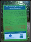 Road Conversion Info |
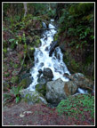 Waterfall |
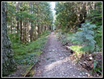 Road Narrows To Trail |
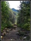 Summit Is In Sight |
 Mt. Rainier |
 Ridge & Summit |
 Road/Trail & Mt. Si |
 Si Haystack |
 View South |
 Mailbox Peak |
 Finally Some Snow! |
 Old Cabin Site |
 On The New Ridge Trail |
 New Trail |
 Now On Kamikaze Trail |
 Just Below Summit |
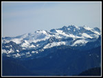 Snowy Crest Peaks |
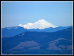 Mt. Baker |
 Rainier Close Up |
 Rattlesnake Lake |
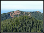 Dixie Peak |
 Downtown Seattle |
 Mt. Si Summit |
 More Snowy Peaks |
 Summit Trio |
 New Trail & Boot Path |
 Peak From Saddle |
 Hikers On Summit |
 Descending Road/Trail |
 Culvert Removed |
 Last Summit View |
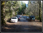 Lot Is Full |
Trips - 2015
Home