9-05-15
For
the first day of the Labor Day Weekend I planned a long day hike. With
work to do on Sunday a backpacking trip was out. This was also supposed
to be the sunniest day. That part was not exactly true. The Pacific
Crest Trail (PCT) is steadily and gently graded north of Snoqualmie
Pass. It hikes very fast. After a blazing hot summer the past week had
been wet and cool. I was out the door by 7:25 am heading east. Exit at
Snoqualmie Pass and quickly into the trailhead parking lot. To my
surprise, the lot was 80% full at 8:25 am. The cloud level was right
about trailhead elevation. It had been sunny in Seattle but not in the
mountains. It seemed awfully thick to expect it to burn off. It was
cold enough for gloves at the start. By 8:35 am I was on the move.
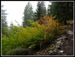
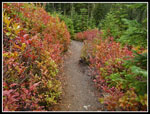
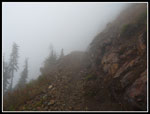
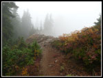
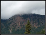
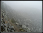
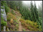
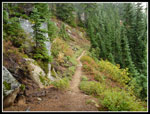
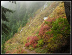
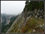
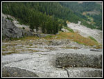
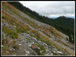
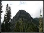
This trail is very busy all summer long. I always plan for an early start to avoid the crowds. That was not the case this day. There were a number of folks to pass or by passed by. I considered the Commonwealth Creek short cut but it starts out a little brushy and the brush was wet. The cool weather, a light day pack, and light hiking shoes allowed for a fast pace. Where the trail descends through the rock field I looked for the great views of Guye Peak and Red Mountain. Not this day. Nothing was visible except for clouds and more clouds. There is a little fall color out now though. I hiked past the Commonwealth Creek connector trail and soon reached the old "4k" marker. I hiked the first 2.5 miles in 52 minutes. Not bad for uphill. Even with the recent rain the small waterfall that showers down on hikers in the spring and early summer was dry. At least the hike was dry too. The next creek can be interesting to cross early in the year. There was water running there but not much.
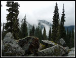
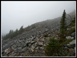
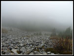
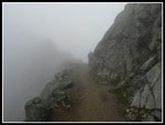
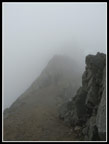
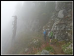
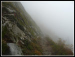
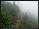
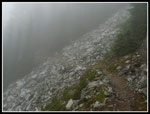
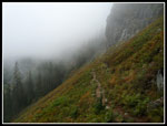
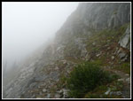
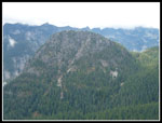
Crossing the avalanche swath I looked up but could not see any of Kendall Peak up above. When the trail neared the ridge a very cold wind blew through the forest. A caught up with several more parties along here. The trail leaves the ridge and soon breaks out onto the big talus field below Kendall Peak. The breeze seemed to be a headwind now. Cold but not enough to put on a jacket and sweat inside it. No views at all. No highway, no Guye Peak, no summit ridge above. The thick clouds seemed to cut out the traffic noise and the sight of anyone else. Instant solitude on a busy trail. There had been reports of snow the previous day above 5500' At near 5000' I did not see any traces. The trail wraps around the west side of Kendall. I could hear folks coming before I could see them. A few backpackers were coming out. Up the switchbacks I went. At the Kendall Peak summit climbers trail I decided the lack of views suggested I pass on the summit.
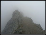
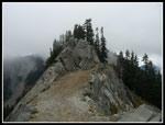
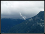
Around to the north side the wind was gone. It was instantly much warmer. I stopped where the trail first reaches the ridge. Looking out I saw white clouds. Looking down to Gold Creek I saw the same. The wind was back and since most of the climbing was over I stopped to put on my jacket. Much better and not too hot at all. A few ups and downs and I arrived at the Kendall Katwalk. A good sized group was right at the point the trail switches from the west to east side of the ridge. Ironically the wind was howling there. 30 feet ahead where the trail is on the east side it was dead calm. Hiking across the Katwalk was interesting. I could only see about 30' ahead. One hiker appeared out of the cloud as he hiked back. I arrived at the Katwalk at 10:54 am. The hike up took 2:19 to cover 5.25 miles.
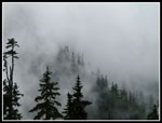
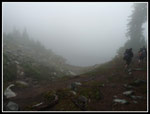
I had expected a sunny day to enjoy all the great mountain views. It was still pea soup. On many occasions I have hiked to Ridge and Gravel Lakes. I had not ever gone farther. This day the plan was to go at least another mile. I took a short break and several more hikers moved on by. A number of PCT through hikers are reaching this area on their way from Mexico to Canada. At least with the guys, a big beard is the usual distinguishing feature. The trail seemed very different with no views. Rather than looking out at the peaks I looked close by at the trail corridor itself. A trail I have hiked many times but this time it was much different.
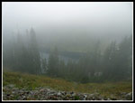
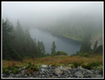
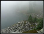
The trail dropped down to Ridge and Gravel Lakes. At the gap above the lakes the wind was blowing hard once again. I took a photo of the white cloudy spot where Ridge Lake sits. A big group passed me by here. Once back on the go the wind immediately died down. I started hiking behind another hiker. Turns out he is a through hiker. The recent rain and cool weather reopened the PCT farther north the day before. Fires had cosed it for weeks. Those who hiked too fast found themselves unable to complete the trek. His speed was perfect. He was within two weeks of reaching Canada. About 1.25 miles beyond the lake I stopped. It turns out I was right below Alaska Mountain. I could not see a thing. After 7.5 miles of hiking it was time for lunch. It was just about noon. 7.5 miles in 3.5 hours.
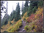
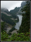
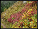
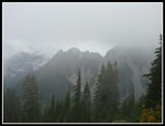
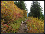
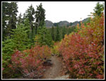
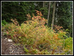
On the way back the trail reaches a spot where it nearly reaches the ridge top. I went up to the ridge and looked down the other side. There was Edd's Lake. I new of it and had seen photos but this was the first time I had seen it. A very long skinny lake. This was not the place to reach the lake as the slope was nearly vertical. The best fall color of the day was in the stretch beyond Ridge Lake. No backlighting to bring out the colors but some good colors nonetheless. The clouds had lightened just enough that I could now clearly see Alaska Lake below the trail.
Passing by Ridge Lake there were now two camps set up below the trail on the Gravel Lake side. It would be an interesting backpacking trip as the rainy weather would be coming in the next day. I met a number of parties coming in as I hiked back to the Katwalk. One person in shorts and a short sleeve shirt must have been borderline hypothermic but was smiling and having fun. The Katwalk was almost out of the clouds. I could even see the summit of Kendal Peak. Much of Gold Creek Valley was now visible too. Alta Mountain was firmly stuck in the clouds however. The Katwalk was empty. I picked up the pace for the hike down. Pace is relative though as two climbers hefting a rope zoomed on by. They went all the way to the base of the summit on Mount Thomson before deciding zero visibility was not good enough conditions to continue. A wise decision.
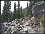
Hiking down I continued to meet folks coming up. I passed a number of folks heading down too. All the rock became a bit tedious up high but the gentle grade made up for it. In the forest the trail is pretty smooth. Once back in forest I ditched the jacket. I reached the parking lot at about 4:15 pm. 2:15 down from the Katwalk was not much different than my time going up. The day was gray but dry. On the drive home I had the fun of two microbursts with rain heavy enough to turn the freeway into a river. Other than the lack of views this hike was outstanding. A fast hike in cool conditions with some good fall color and not nearly as crowded as it can be. I seem to hike this trail most often in the fall. Conditions can vary from sunny to snowy. This day I had gray and that was not so bad.
Click on thumbnails to get
larger pictures.
Trips - 2015
Home
This trail is very busy all summer long. I always plan for an early start to avoid the crowds. That was not the case this day. There were a number of folks to pass or by passed by. I considered the Commonwealth Creek short cut but it starts out a little brushy and the brush was wet. The cool weather, a light day pack, and light hiking shoes allowed for a fast pace. Where the trail descends through the rock field I looked for the great views of Guye Peak and Red Mountain. Not this day. Nothing was visible except for clouds and more clouds. There is a little fall color out now though. I hiked past the Commonwealth Creek connector trail and soon reached the old "4k" marker. I hiked the first 2.5 miles in 52 minutes. Not bad for uphill. Even with the recent rain the small waterfall that showers down on hikers in the spring and early summer was dry. At least the hike was dry too. The next creek can be interesting to cross early in the year. There was water running there but not much.
Crossing the avalanche swath I looked up but could not see any of Kendall Peak up above. When the trail neared the ridge a very cold wind blew through the forest. A caught up with several more parties along here. The trail leaves the ridge and soon breaks out onto the big talus field below Kendall Peak. The breeze seemed to be a headwind now. Cold but not enough to put on a jacket and sweat inside it. No views at all. No highway, no Guye Peak, no summit ridge above. The thick clouds seemed to cut out the traffic noise and the sight of anyone else. Instant solitude on a busy trail. There had been reports of snow the previous day above 5500' At near 5000' I did not see any traces. The trail wraps around the west side of Kendall. I could hear folks coming before I could see them. A few backpackers were coming out. Up the switchbacks I went. At the Kendall Peak summit climbers trail I decided the lack of views suggested I pass on the summit.
Around to the north side the wind was gone. It was instantly much warmer. I stopped where the trail first reaches the ridge. Looking out I saw white clouds. Looking down to Gold Creek I saw the same. The wind was back and since most of the climbing was over I stopped to put on my jacket. Much better and not too hot at all. A few ups and downs and I arrived at the Kendall Katwalk. A good sized group was right at the point the trail switches from the west to east side of the ridge. Ironically the wind was howling there. 30 feet ahead where the trail is on the east side it was dead calm. Hiking across the Katwalk was interesting. I could only see about 30' ahead. One hiker appeared out of the cloud as he hiked back. I arrived at the Katwalk at 10:54 am. The hike up took 2:19 to cover 5.25 miles.
I had expected a sunny day to enjoy all the great mountain views. It was still pea soup. On many occasions I have hiked to Ridge and Gravel Lakes. I had not ever gone farther. This day the plan was to go at least another mile. I took a short break and several more hikers moved on by. A number of PCT through hikers are reaching this area on their way from Mexico to Canada. At least with the guys, a big beard is the usual distinguishing feature. The trail seemed very different with no views. Rather than looking out at the peaks I looked close by at the trail corridor itself. A trail I have hiked many times but this time it was much different.
The trail dropped down to Ridge and Gravel Lakes. At the gap above the lakes the wind was blowing hard once again. I took a photo of the white cloudy spot where Ridge Lake sits. A big group passed me by here. Once back on the go the wind immediately died down. I started hiking behind another hiker. Turns out he is a through hiker. The recent rain and cool weather reopened the PCT farther north the day before. Fires had cosed it for weeks. Those who hiked too fast found themselves unable to complete the trek. His speed was perfect. He was within two weeks of reaching Canada. About 1.25 miles beyond the lake I stopped. It turns out I was right below Alaska Mountain. I could not see a thing. After 7.5 miles of hiking it was time for lunch. It was just about noon. 7.5 miles in 3.5 hours.
On the way back the trail reaches a spot where it nearly reaches the ridge top. I went up to the ridge and looked down the other side. There was Edd's Lake. I new of it and had seen photos but this was the first time I had seen it. A very long skinny lake. This was not the place to reach the lake as the slope was nearly vertical. The best fall color of the day was in the stretch beyond Ridge Lake. No backlighting to bring out the colors but some good colors nonetheless. The clouds had lightened just enough that I could now clearly see Alaska Lake below the trail.
Passing by Ridge Lake there were now two camps set up below the trail on the Gravel Lake side. It would be an interesting backpacking trip as the rainy weather would be coming in the next day. I met a number of parties coming in as I hiked back to the Katwalk. One person in shorts and a short sleeve shirt must have been borderline hypothermic but was smiling and having fun. The Katwalk was almost out of the clouds. I could even see the summit of Kendal Peak. Much of Gold Creek Valley was now visible too. Alta Mountain was firmly stuck in the clouds however. The Katwalk was empty. I picked up the pace for the hike down. Pace is relative though as two climbers hefting a rope zoomed on by. They went all the way to the base of the summit on Mount Thomson before deciding zero visibility was not good enough conditions to continue. A wise decision.
Hiking down I continued to meet folks coming up. I passed a number of folks heading down too. All the rock became a bit tedious up high but the gentle grade made up for it. In the forest the trail is pretty smooth. Once back in forest I ditched the jacket. I reached the parking lot at about 4:15 pm. 2:15 down from the Katwalk was not much different than my time going up. The day was gray but dry. On the drive home I had the fun of two microbursts with rain heavy enough to turn the freeway into a river. Other than the lack of views this hike was outstanding. A fast hike in cool conditions with some good fall color and not nearly as crowded as it can be. I seem to hike this trail most often in the fall. Conditions can vary from sunny to snowy. This day I had gray and that was not so bad.
 First Bit Of Fall Color |
 Cloudy View |
 Cloudy Close Up |
 Hiker Ahead |
 Very Nice Color |
 Muted Colors |
 Misty Big Talus Field |
 Very Cloudy Below |
 What Cliffs? |
 Reaching The Ridge |
 Reaching The Katwalk |
 What Visibility? |
 Spot The Hikers |
 Red Mountain |
 Into The Mist |
 Still In The Clouds |
 Through More Rocks |
 Hiker Approaches |
 Ridge Lake? |
 Misty Alaska Lake |
 Out Of The Clouds |
 Cloudy Again |
 Edd's Lake |
 Almost Sun |
 Doe A Deer |
 Two Deer |
 Very Good Colors |
 Back Into Clouds |
 Clearer Alaska Lake |
 No Views Today |
 Ridge Lake Again |
 Ridge In View |
 Clear Katwalk |
 Looking Down |
 Blasted Ridge Top |
 It Looks Like Fall |
 I Can See For Miles |
 Guye Peak Summit |
 Wispy Clouds |
 Excellent Colors |
 Guye Peak |
 Last Color |
Trips - 2015
Home