5-30-15
This
loop trip is an old favorite. One I have done four times previously.
The last time was on 8-21-04. Eleven years had slipped by. I checked my
2004
trip report and it concluded
with "I don't think I'll wait 11 years to return". I waited
11 years to return. It was past time. I was on the road by 6:40 am and
cruised over Snoqualmie Pass. I drove through Roslyn and Ronald and up
the road along Lake Cle Elum. A left onto the Cooper Lake Road and a
right to the lake. The bridge over the Cooper River had a lot of
standing water. My sedan went almost bumper deep. Looks like they had a
lot of rain recently. It was much less deep on the way out. I reached
the parking lot at 8:40 am. Half a dozen cars were in the lot. Since my
last visit a big new outhouse has been installed. By 8:50 am I was on
my way.
The brush was all wet due to all that recent rain. Vanilla leaf started right away. There was a good variety of wildflowers in bloom all along the way. This is a pretty long trip with most of the climbing in the first one third of the way. An early start on a sunny day is a good idea. Most all the creeks were running though I saw almost no snow on the trip. Must have been that rain. I managed to rock hop them all with nearly dry feet. The trail guides say it is 1 mile to the Tired Creek Trail junction. My GPS said 1 1/3 miles. The junction is obvious if you are looking for it. Less so if you are hiking fast. It is a short way after crossing Tired Creek.
The Tired Creek Trail was a clear cut on my first visit some 27 years ago. Now the forest is beginning to enclose it again. There are some narrow sections where I soaked my pants on the wet brush. No problem on a warm summer day. Shortly the trail reaches the old logging road. At one time this was a shortcut to Pete Lake. The trail from the road is still signed on the Pete Lake Trail. The road is now gated and the bridge over Tired Creek has been removed. The trail I climbed up is well signed at the old road. The direction to continue up the trail is not. Turn right and hike to the missing bridge over Tired Creek. The trail is well marked here too.
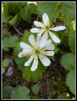
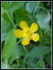
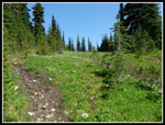
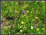
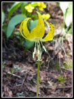
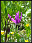
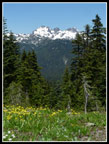
On an earlier visit this next section had recently been burned. Almost no traces left now. Most of the more than 2200' of gain to the old lookout site are in forest which can be good with the southern exposure on a hot day. It does impede views though there are a couple of good viewpoints. Strawberries were in bloom. I also saw Indian paintbrush, lupine, penstemon, buttercups, yellow violets, trillium, marsh marigolds, shooting stars, glacier lilies, phlox, desert parsley, and more. The wetter meadows up high had a lot of the wildflowers though there were patches on much of the way up. The trail is in good shape. It has always been a little rocky down low but most of the way is fine.
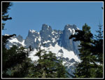
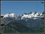
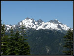
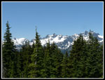
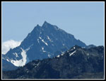
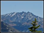
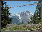
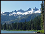
There were signs of a good deal of trail reconstruction since my 2004 visit. Sections have been widened and smoothed. In a few spots the grade has been rebuilt entirely. I was surprised but pleased that a lesser used trail received some serious work. At a switchback there is a view out to the Cascade Crest peaks. Three Queens, Four Brothers, Chikamin, and Lemah Mountain are right in your face. With blue sky and white snow they looked great.
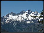
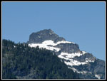
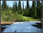
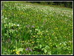
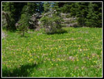
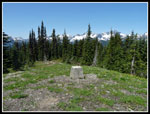
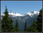
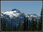
More switchbacks finally gave way to gentler grade and a straight shot towards the top of Polallie Ridge. Along here are the meadows. A few small snow patches left but not for long. Plenty of running water had a bevy of wildflowers in bloom. Big patches of yellow glacier lilies and buttercups mixed in with a lot of white marsh marigolds. Add patches of purple shooting stars and it made for great color. A few minutes later I reached the ridge top junction. Right a short steep eighth of a mile is the lookout site. It was now 11:27 am. The view from the 5482' site is outstanding. Over the 27 years since my first visit trees have been growing taller. Now they block small bits of the full view. For the most part the view is still open. Mt. Rainier to the southwest then all the peaks north of Snoqualmie Pass, Three Queens, Alta, the ones seen from lower on the trail, then Chimney Rock, Overcoat, Summit Chief and the other Chiefs, Bears Breast, Hinman, and Daniel. Farther east I recognized The Cradle, then Mt. Stuart. This is absolutely one of the best viewpoints for the east side of the Cascade Crest peaks north of Snoqualmie Pass.
I had a nice long lunch break on top. I did not pack up and leave until 12:15 pm. More than 45 minutes to enjoy the peaks and the sunshine with a nice cool breeze. 5 miles down but I still had nearly 9 miles to go. I did have 90% of the elevation gain out of the way. I quickly backtracked to the junction and headed down on the trail to Waptus Pass. There are several steep drops and some gentler terrain. At some point since my last visit a lot of trees fell across the trail. The cut ends looked like they were removed about 5-8 years ago. Again, nice to see maintenance on a lesser used trail. There were about a dozen logs down on the rest of the route to Pete Lake. None prove difficult for a hiker to get over. Some would be a problem for horses. I dragged two of the smaller ones off the trail. The rest were too big for the saw I carried. None needed limbing.
The creek near Waptus Pass had a lot of running water. No problem if camping at the sites there. On the flatter terrain for the next mile or so there were a lot of muddy sections. These will dry out soon.There were some more wildflowers, especially marsh marigolds, but not close to the show on the upper Tired Creek Trail. A number of ups and downs here as I gained over 100' at one point. The bridges over marshy areas were nearly new in 2004. They still look good. The junction with the Waptus Burn trail is well marked. I was not heading for the Pacific Crest Trail this day. A little farther the trail to Escondido Lake is also well marked. Just before it a trail to a campsite is as big as the main trail. I took a short wrong turn. Now finally the trail gets down to business dropping down to Pete Lake.
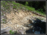
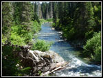
There are two good sized creek crossings. These two form the Cooper River. The other part of the river comes out of Cooper Lake and is still Lemah Creek at that point. I did not know that before the trip. The first crossing is just before the trail junction for Escondido Lake. The second is a little after and is the outlet from the lake. I rock hopped them both. Earlier with higher water they could be trouble. There is a nice small waterfall above one crossing. The trail continues good as it switchbacks down the slope. Part way down it gets very rocky. This is my least favorite part of the whole loop. There are some views out to Three Queens, now even closer.
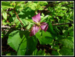
The day was rapidly getting much warmer. My cool breeze on the summit was now a hot breeze if any. At long last I reached flat ground and soon Pete Lake. The first few shoreline spots I tried were taken. I did find a spot near the outlet where I had views of the Cascade Crest peaks behind the lake. There was even a breeze blowing across the lake. I arrived at 2:28 pm. Just over two hours hiking time from the lookout site. About 4.5 miles hiked. Right on the shore I found a patch of bleeding hearts in bloom. The only ones I saw all day. I really did not want to leave. The 4.4 miles back to the car are mostly flat with no views and only a few glimpses of the Cooper River. Just a long forest walk. The lake was very nice. I stayed until 2:53 pm. twenty five minutes was not enough.
Reluctantly I headed back. The hike out was pretty quick. By 4:15 pm I was back at the trailhead. 4.4 miles in 1:22. Under 19 minute miles is fast for me. For the first 5.5 hours covering 9.6 miles I saw exactly zero people. From Pete Lake out I saw a dozen groups as one would expect. Most of the loop provides a great deal of solitude. It also provides great wildflowers and views of snowy peaks. It really should be a hike I do at least every five years. Totals are about 14 miles with 2900' of gain. So again I'll end this report by saying, "I don't think I'll wait 11 years to return".
Click on thumbnails to get
larger pictures.
Trips - 2015
Home
The brush was all wet due to all that recent rain. Vanilla leaf started right away. There was a good variety of wildflowers in bloom all along the way. This is a pretty long trip with most of the climbing in the first one third of the way. An early start on a sunny day is a good idea. Most all the creeks were running though I saw almost no snow on the trip. Must have been that rain. I managed to rock hop them all with nearly dry feet. The trail guides say it is 1 mile to the Tired Creek Trail junction. My GPS said 1 1/3 miles. The junction is obvious if you are looking for it. Less so if you are hiking fast. It is a short way after crossing Tired Creek.
The Tired Creek Trail was a clear cut on my first visit some 27 years ago. Now the forest is beginning to enclose it again. There are some narrow sections where I soaked my pants on the wet brush. No problem on a warm summer day. Shortly the trail reaches the old logging road. At one time this was a shortcut to Pete Lake. The trail from the road is still signed on the Pete Lake Trail. The road is now gated and the bridge over Tired Creek has been removed. The trail I climbed up is well signed at the old road. The direction to continue up the trail is not. Turn right and hike to the missing bridge over Tired Creek. The trail is well marked here too.
On an earlier visit this next section had recently been burned. Almost no traces left now. Most of the more than 2200' of gain to the old lookout site are in forest which can be good with the southern exposure on a hot day. It does impede views though there are a couple of good viewpoints. Strawberries were in bloom. I also saw Indian paintbrush, lupine, penstemon, buttercups, yellow violets, trillium, marsh marigolds, shooting stars, glacier lilies, phlox, desert parsley, and more. The wetter meadows up high had a lot of the wildflowers though there were patches on much of the way up. The trail is in good shape. It has always been a little rocky down low but most of the way is fine.
There were signs of a good deal of trail reconstruction since my 2004 visit. Sections have been widened and smoothed. In a few spots the grade has been rebuilt entirely. I was surprised but pleased that a lesser used trail received some serious work. At a switchback there is a view out to the Cascade Crest peaks. Three Queens, Four Brothers, Chikamin, and Lemah Mountain are right in your face. With blue sky and white snow they looked great.
More switchbacks finally gave way to gentler grade and a straight shot towards the top of Polallie Ridge. Along here are the meadows. A few small snow patches left but not for long. Plenty of running water had a bevy of wildflowers in bloom. Big patches of yellow glacier lilies and buttercups mixed in with a lot of white marsh marigolds. Add patches of purple shooting stars and it made for great color. A few minutes later I reached the ridge top junction. Right a short steep eighth of a mile is the lookout site. It was now 11:27 am. The view from the 5482' site is outstanding. Over the 27 years since my first visit trees have been growing taller. Now they block small bits of the full view. For the most part the view is still open. Mt. Rainier to the southwest then all the peaks north of Snoqualmie Pass, Three Queens, Alta, the ones seen from lower on the trail, then Chimney Rock, Overcoat, Summit Chief and the other Chiefs, Bears Breast, Hinman, and Daniel. Farther east I recognized The Cradle, then Mt. Stuart. This is absolutely one of the best viewpoints for the east side of the Cascade Crest peaks north of Snoqualmie Pass.
I had a nice long lunch break on top. I did not pack up and leave until 12:15 pm. More than 45 minutes to enjoy the peaks and the sunshine with a nice cool breeze. 5 miles down but I still had nearly 9 miles to go. I did have 90% of the elevation gain out of the way. I quickly backtracked to the junction and headed down on the trail to Waptus Pass. There are several steep drops and some gentler terrain. At some point since my last visit a lot of trees fell across the trail. The cut ends looked like they were removed about 5-8 years ago. Again, nice to see maintenance on a lesser used trail. There were about a dozen logs down on the rest of the route to Pete Lake. None prove difficult for a hiker to get over. Some would be a problem for horses. I dragged two of the smaller ones off the trail. The rest were too big for the saw I carried. None needed limbing.
The creek near Waptus Pass had a lot of running water. No problem if camping at the sites there. On the flatter terrain for the next mile or so there were a lot of muddy sections. These will dry out soon.There were some more wildflowers, especially marsh marigolds, but not close to the show on the upper Tired Creek Trail. A number of ups and downs here as I gained over 100' at one point. The bridges over marshy areas were nearly new in 2004. They still look good. The junction with the Waptus Burn trail is well marked. I was not heading for the Pacific Crest Trail this day. A little farther the trail to Escondido Lake is also well marked. Just before it a trail to a campsite is as big as the main trail. I took a short wrong turn. Now finally the trail gets down to business dropping down to Pete Lake.
There are two good sized creek crossings. These two form the Cooper River. The other part of the river comes out of Cooper Lake and is still Lemah Creek at that point. I did not know that before the trip. The first crossing is just before the trail junction for Escondido Lake. The second is a little after and is the outlet from the lake. I rock hopped them both. Earlier with higher water they could be trouble. There is a nice small waterfall above one crossing. The trail continues good as it switchbacks down the slope. Part way down it gets very rocky. This is my least favorite part of the whole loop. There are some views out to Three Queens, now even closer.
The day was rapidly getting much warmer. My cool breeze on the summit was now a hot breeze if any. At long last I reached flat ground and soon Pete Lake. The first few shoreline spots I tried were taken. I did find a spot near the outlet where I had views of the Cascade Crest peaks behind the lake. There was even a breeze blowing across the lake. I arrived at 2:28 pm. Just over two hours hiking time from the lookout site. About 4.5 miles hiked. Right on the shore I found a patch of bleeding hearts in bloom. The only ones I saw all day. I really did not want to leave. The 4.4 miles back to the car are mostly flat with no views and only a few glimpses of the Cooper River. Just a long forest walk. The lake was very nice. I stayed until 2:53 pm. twenty five minutes was not enough.
Reluctantly I headed back. The hike out was pretty quick. By 4:15 pm I was back at the trailhead. 4.4 miles in 1:22. Under 19 minute miles is fast for me. For the first 5.5 hours covering 9.6 miles I saw exactly zero people. From Pete Lake out I saw a dozen groups as one would expect. Most of the loop provides a great deal of solitude. It also provides great wildflowers and views of snowy peaks. It really should be a hike I do at least every five years. Totals are about 14 miles with 2900' of gain. So again I'll end this report by saying, "I don't think I'll wait 11 years to return".
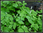 Vanilla Leaf |
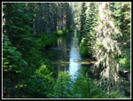 Cooper River |
 Past Prime Trillium |
 First Views Out |
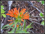 Indian Paintbrush |
 Penstemon |
 First Big Viewpoint |
 Lemah Mountain |
 Three Queens Summit |
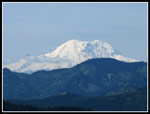 Mt. Rainier |
 Wilderness Boundary |
 Marsh Marigolds |
 Buttercup Like |
 A Little Snow |
 Meadows |
 Wildflowers |
 Glacier Lily |
 Shooting Star |
 Lots Of Wildflowers |
 Glacier Lilies |
 Lookout Site |
 Summit Chief |
 Hinman & Daniel |
 Three Queens & Alta |
 Cascade Crest Peaks |
 Mt. Stuart |
 Snowy Peaks & Flowers |
 The Cradle |
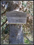
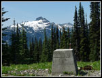 Lookout Support Block |
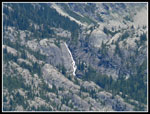 Big Waterfall |
 Bears Breast Mountain |
 Log Across Trail |
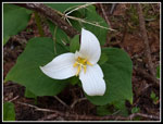 Trillium |
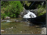 Creek Crossing & Falls |
 Rocky Trail |
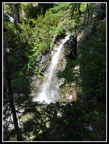 Another Waterfall |
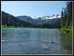 Pete Lake View |
 Lemah From Pete Lake |
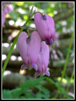 Bleeding Hearts |
 Leaving Pete Lake |
Trips - 2015
Home