12-19-15
Kim
joined me for a lower elevation
hike to Wallace Falls and Lake. This is a hike I do most winters. The
lake is at only 1844' and often has little or now snow in the winter.
Last December I hiked the loop to the falls and the lake and found a
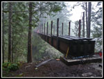
new bridge under construction. It is above the upper falls viewpoint.
The boot path climbs up to an old road. Left goes to Wallace Lake.
Right has ended at a missing logging bridge just before the river drops
over the upper falls. Plans to connect the Wallace Lake State Park
trails to new trails coming in the Reiter ORV and hiking trails system.
I meant to come back earlier to see the new bridge. It was past time.
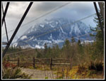
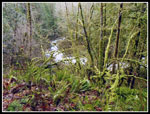
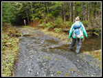
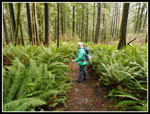
Kim and I headed out of North Seattle at 7:45 am. By 8:45 am we were at the trailhead located just outside of Gold Bar off Highway 2. There were a dozen or so cars in the lot already. It rained most of the night and early morning but it was dry when we started out. Dry but cold. It was in the mid to upper 30s all day. Fortunately, the wind was very light. The route begins under the power lines. Just before going into the forest there is a great view of Mt. Baring and Mts. Index and Persis. Not so much today. No Baring and just a little of Persis. The snow level was near our elevation on the south side of the valley. It was quite a bit higher on the north side where we were hiking. At the first junction we went right on the Woody Trail along the Wallace River. We came down on the other option, the Railroad Grade Trail.
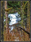
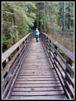
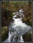
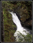
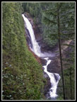
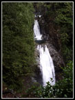
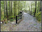
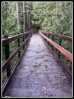
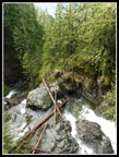
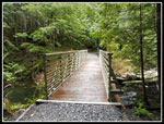
The river had a good flow though nothing like the recent flood levels. Several faster parties passed us along here. We enjoyed the trail and views of the river. There are a few ups and downs. We passed the two side trails that go up to the Railroad Grade then dropped to the bridge crossing the NF Wallace River. Much of the elevation gain on the whole hike comes in the next few miles or less to the top of the upper falls. A steep climb brought us to the covered picnic spot. There is a nice view of the cascades and the middle falls. I always stop for photos here. Heading on up the trail we met several groups already heading down. We stopped at the middle falls viewpoint then headed up to the upper falls viewpoint. A good water flow but the mist was nowhere near to reaching the viewpoint. After a short stop we followed the short boot path turns to trail up to the old road. A right turn quickly took us to the new bridge site.
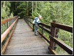
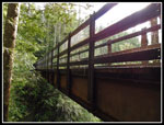
Last December there was only the frame with no decking and vertical posts with no railing. Now it is finished. The railing is very high. A shorter person will not be able to see over the top. The builders did put a lower railing on the downstream side in the middle. Much better for short folks to take photos. I will come back later to explore the old road/trails on the other side of the bridge. After a food break we headed off on the road to Wallace Lake, some 2.4 miles away. When I first hiked this old road in the late 1980s it was long abandoned. Narrow, grassy, and muddy in many places. It is much different now. More logging was returned it to a freshly graveled road much of the way. It is still dirt to the edge of the state park. Since my last visit logging has reached the park boundary.
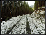
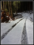
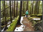
A new spur turns to the left. There is not yet a sign here. The main road/trail goes to the right. As we came out of the woods there was snow on the road. Just a little at first then enough to cover the road. It looked like winter but it was not deep enough to slow us down much. We passed a hiker here going in the opposite direction. The only person we saw between the middle falls and the Railroad Grade several hours later. Once away from the falls the trails are not very busy. At most there was a couple of inches of snow. When we left the road for the old dirt spur to the lake the snow was nearly all gone. At the late outlet we found a brand new bridge. It was not there last December. Steel with wooden decking. Time for a last food and water break at the outlet before heading down.
In order to bring in the new bridge, the old dirt spur road that leads down to the Greg Ball Trail was covered in a thick layer of gravel. The soft dirt is now hard rock. With the middle section between falls and lake returned to gravel road and now this section, the route is getting to be hard on the feet. Mine were not happy. We soon reached the lower gravel road, took a right turn, and in short order were at the top of the Greg Ball Trail. The upper part of this trail can be muddy. After all the recent rain I expected it to be mushy. It was not bad at all. We were most of the way down when we finally saw another hiker. At the bottom of the trail we met up with the Railroad Grade Trail. It was starting to rain at that point but a few minutes later it stopped. I carried an umbrella all the way around the loop and never used it.
On the grade we met a few more groups heading up. This route is longer than dropping down to the Woody Trail but it is smooth, gently graded, and not as crowded. We left forest at the power line corridor and there was still no view of Mt. Baring. We had a little sunshine during the hike but it was all cloudy once again. We did have a partial view of towards Persis though the top was in the clouds. The last bit of gravel road and we were back at the trailhead. By 3:45 pm we were ready to head out. I thought we might be early enough to miss the ski traffic. It was wide open turning onto Highway 2. Within a few miles we reached the backup. Stop and go all the way through Sultan. It added about 45 minutes to the drive home but was far from the worst I have seen on Highway 2.
As mentioned, this is a favorite winter hike. We had a taste of fresh snow but just enough to cover the ground without slowing us down much. It was cold all day but never below freezing. The forecast rain held off all day long. Without a trip to the far end of Wallace Lake the loop was 10 miles with 1700' of elevation gain. A good long trip on just about the shortest day of the year. We had only 8:25 between sunrise and sunset. After documenting the building of the new Murat Bridge I was eager to check out the finished bridge above the upper falls. I paced it off at roughly 124' long. About 76' shorter than the Tiger Mountain bridge but still a very long one. Kim and I had a great day on the trail.
Click on thumbnails to get
larger pictures.
Trips - 2015
Home
Kim and I headed out of North Seattle at 7:45 am. By 8:45 am we were at the trailhead located just outside of Gold Bar off Highway 2. There were a dozen or so cars in the lot already. It rained most of the night and early morning but it was dry when we started out. Dry but cold. It was in the mid to upper 30s all day. Fortunately, the wind was very light. The route begins under the power lines. Just before going into the forest there is a great view of Mt. Baring and Mts. Index and Persis. Not so much today. No Baring and just a little of Persis. The snow level was near our elevation on the south side of the valley. It was quite a bit higher on the north side where we were hiking. At the first junction we went right on the Woody Trail along the Wallace River. We came down on the other option, the Railroad Grade Trail.
The river had a good flow though nothing like the recent flood levels. Several faster parties passed us along here. We enjoyed the trail and views of the river. There are a few ups and downs. We passed the two side trails that go up to the Railroad Grade then dropped to the bridge crossing the NF Wallace River. Much of the elevation gain on the whole hike comes in the next few miles or less to the top of the upper falls. A steep climb brought us to the covered picnic spot. There is a nice view of the cascades and the middle falls. I always stop for photos here. Heading on up the trail we met several groups already heading down. We stopped at the middle falls viewpoint then headed up to the upper falls viewpoint. A good water flow but the mist was nowhere near to reaching the viewpoint. After a short stop we followed the short boot path turns to trail up to the old road. A right turn quickly took us to the new bridge site.
Last December there was only the frame with no decking and vertical posts with no railing. Now it is finished. The railing is very high. A shorter person will not be able to see over the top. The builders did put a lower railing on the downstream side in the middle. Much better for short folks to take photos. I will come back later to explore the old road/trails on the other side of the bridge. After a food break we headed off on the road to Wallace Lake, some 2.4 miles away. When I first hiked this old road in the late 1980s it was long abandoned. Narrow, grassy, and muddy in many places. It is much different now. More logging was returned it to a freshly graveled road much of the way. It is still dirt to the edge of the state park. Since my last visit logging has reached the park boundary.
A new spur turns to the left. There is not yet a sign here. The main road/trail goes to the right. As we came out of the woods there was snow on the road. Just a little at first then enough to cover the road. It looked like winter but it was not deep enough to slow us down much. We passed a hiker here going in the opposite direction. The only person we saw between the middle falls and the Railroad Grade several hours later. Once away from the falls the trails are not very busy. At most there was a couple of inches of snow. When we left the road for the old dirt spur to the lake the snow was nearly all gone. At the late outlet we found a brand new bridge. It was not there last December. Steel with wooden decking. Time for a last food and water break at the outlet before heading down.
In order to bring in the new bridge, the old dirt spur road that leads down to the Greg Ball Trail was covered in a thick layer of gravel. The soft dirt is now hard rock. With the middle section between falls and lake returned to gravel road and now this section, the route is getting to be hard on the feet. Mine were not happy. We soon reached the lower gravel road, took a right turn, and in short order were at the top of the Greg Ball Trail. The upper part of this trail can be muddy. After all the recent rain I expected it to be mushy. It was not bad at all. We were most of the way down when we finally saw another hiker. At the bottom of the trail we met up with the Railroad Grade Trail. It was starting to rain at that point but a few minutes later it stopped. I carried an umbrella all the way around the loop and never used it.
On the grade we met a few more groups heading up. This route is longer than dropping down to the Woody Trail but it is smooth, gently graded, and not as crowded. We left forest at the power line corridor and there was still no view of Mt. Baring. We had a little sunshine during the hike but it was all cloudy once again. We did have a partial view of towards Persis though the top was in the clouds. The last bit of gravel road and we were back at the trailhead. By 3:45 pm we were ready to head out. I thought we might be early enough to miss the ski traffic. It was wide open turning onto Highway 2. Within a few miles we reached the backup. Stop and go all the way through Sultan. It added about 45 minutes to the drive home but was far from the worst I have seen on Highway 2.
As mentioned, this is a favorite winter hike. We had a taste of fresh snow but just enough to cover the ground without slowing us down much. It was cold all day but never below freezing. The forecast rain held off all day long. Without a trip to the far end of Wallace Lake the loop was 10 miles with 1700' of elevation gain. A good long trip on just about the shortest day of the year. We had only 8:25 between sunrise and sunset. After documenting the building of the new Murat Bridge I was eager to check out the finished bridge above the upper falls. I paced it off at roughly 124' long. About 76' shorter than the Tiger Mountain bridge but still a very long one. Kim and I had a great day on the trail.
 Cloudy Mt. Persis |
 First Falls |
 NF Wallace River Bridge |
 NF Wallace River |
 Green Forest |
 Witches Butter |
 Lower Falls |
 Middle Falls |
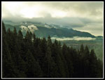 Skykomish Valley |
 Upper Falls |
 New Bridge |
 124' Long |
 Lower Railing |
 Above Upper Falls |
 Along New Bridge |
 Bridge Last December |
 Snow On Road/Trail |
 Deepest Snow |
 Mossy Rock |
 Map Near Lake |
 Easy Crossing This Time |
 New Lake Bridge |
 Wallace Lake |
 Greg Ball Trail |
 Sword Ferns |
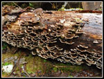 Turkey Tail Fungi |
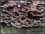 Close Up |
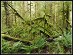 Mossy Forest |
Trips - 2015
Home