6-25-16
This
was an unusual trip. Gary,
John, and I have an accumulated 90 or so years of hiking. Cow Heaven
was in the 100 Hikes in the North Cascades book decades ago. Still,
none of us had done this hike. I'm always up for a new trail. I met
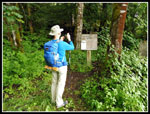
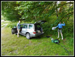
Gary and John at the 164th St. Park and Ride at 7:20 am and we headed
north. Through Arlington and Darrington to the North Cascades Highway.
In Marblemount we turned onto the Ranger Station Road and a quarter
mile after the end of pavement came to the small trailhead. Parking for
about three or four cars. We were on the trail just after 9:00 am. It
was cool and misty in the morning. There was supposed to be some
clearing in the afternoon. This hike is about elevation gain. The
trailhead is at only 400'. The Tiger Mountain trailhead on I-90 just
outside of Issaquah near Seattle is at 500'. The summit of the first
Helen Butte is just over 5400'. That is 5000' without any ups and
downs. We knew we were in for a long climb.
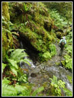
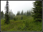
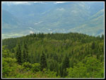
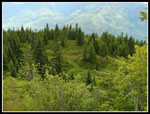
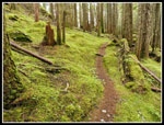
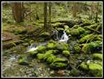
The trail quickly reaches a small falls. An easy rock hop this time of year. There are several more creek crossings in the first half of the hike to Cow Heaven. All easy rock hops or in one case a plank to walk across. The route begins pretty smooth with a consistent grade. It did not seem that steep though the climbing continues for a long way with few flat spots. The forest is the highlight. No views out for a long time but a very green forest. Moss covers most everything. I have been doing a lot of trips like that recently. We saw some saprophytes, especially coral root. Not as much as on the Old Mason Lake Trail a week ago but quite a bit. It was in the mid to upper 50s much of the way up. It as also humid. My glasses were constantly steamed up and I sweated much more than normal at that temperature. It had rained the day before.
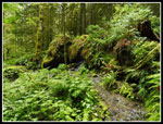
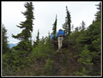
There were many short switchbacks that were efficient in gaining elevation. There is only one short downhill section on the way up. We did find a two mile marker on a tree. It seemed to take a long time to reach it. We also figured out that the trail shown on maps is a fantasy. both GPS units recorded a route that was in the general vicinity but not even close to what is on maps. There are many more switchbacks in reality. After about 3000' of climbing the big trees began to get smaller. Some brush started to appear. The trail began to follow a forested ridge. We read about one big tree down and finally reached it. The trail goes to the right and then follows right next to the tree. Hardly a detour at all.
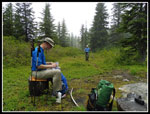
As the trail became brushier the brush was now soaking wet. We whacked it with poles and a lot of water went flying. The rest ended up on us. My boots were soaked in no time. I had earlier zipped off my pants legs. We took turns leading through the wet zone. The trail finally crested to Cow Heaven. There is a campsite there. We found three wood "chairs" there. It was already 12:20 pm and time for lunch. I replaced my soaking wet short sleeve shirt with a long sleeve one. Much warmer. I also put on a jacket for more wet brush bashing.
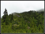
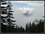
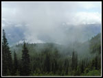
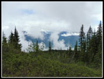
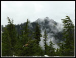
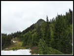
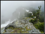
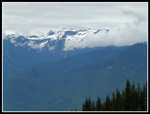
Our break was at about 4300'. He had gained a net of 3900' in 3.8 miles. Helen Buttes were still almost two miles away. We soon were moving again. A few minutes later the nice trail came to a junction. Two minimal trails. We tried left first and it quickly ended at a site with some big animal bones. We backtracked and took the right trail. It was the right trail. It began to climb once again. We climbed up to a rocky point that must have some good views on a clear day. This day was not clear. We slowed down a little earlier hoping the sky would begin to clear. No such luck. A forested ridge was up about us. We could not see much looking out through all the clouds. Cow Heaven was just below us. The route continued to look like a very old built trail, not a boot path. It switchbacked at times. There was a cut bank. At one spot someone built a small rock and stick barrier to show that the route takes a sharp right turn. We kept climbing towards the ridge above.
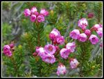
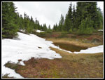
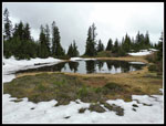
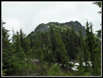
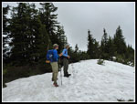
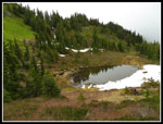
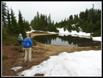
The trail came over the ridge to find some meadow mixed in with more trees. There was now some snow too. The route seemed to end. We could go straight ahead on snow slowly descending a cut in the trees or turn right also with fewer trees. We checked out both and took the right turn. A short distance over the ridge turned to the left. Looking out we saw a ridge at a right angle to the one we were on. It appeared to be Helen Buttes. One high point, a saddle, then another high point. We still had some distance to go. There are not many reports on the buttes and since we decided on this hike only a few days earlier we had very little to go on. We dropped a little along the edge of the ridge and came to a good sized tarn partly surrounded by snow. One could camp there easily as long as the snow lasts.
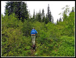
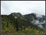
The ridge began to narrow down as we headed towards the buttes. At times we lost the tread under snow but soon found it again. As the trail went around to the west side the snow ended. The ridge began to climb fast and our trail contoured around it on the west side. It still looked to be a trail. Narrow and sloughing in places but with a cut bank. The side hilling was not too hard. The slope was not so steep as to be dangerous. Another meadow was below us. The hillside gave way to another good sized meadow. We could now see a summit well above us. We looked for a route heading up towards the ridge. The meadow was very wet and my feet were quickly soaked once again. The meadow slowly ascended and we found another boot path. We followed it past another tarn until we were under the summit. The path continued on as a ridge headed away form the summit. This had to be the lower southwest Helen Butte. The northeast one was hidden by the first summit.
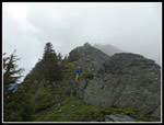
We headed back looking for a route up to the ridge. I had seen a path that looked like it might go up on our way across the meadow. There was an obvious low spot on the ridge above. Below it near the meadow were trees. Much of the slope was all brush. I chose to try heading up in the trees to miss the brush. Part way up I found some plastic tape. The others then come over to my spot. The route went up partly on dirt partly on snow. When I came into slide alder a path was cut through it. Bingo! It was moderately steep but it went just fine to the ridge top. The summit went into and out of clouds. it was just 400' above us. the first part of the ridge was just trees and low brush. Higher up it was rocky. The ridge became very narrow. The route ascended wet grass and rocks. It was now 3:00 pm. Six hours in and not yet at the summit. The route did not look like a walk up. It was getting late. After a quick discussion we decided that a sketchy summit and no views was not worth it. Time to head back.
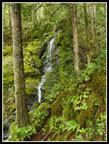
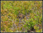
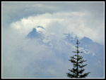
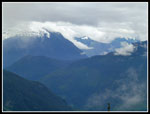
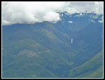
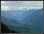
We immediately spooked a bother and two young grouse. One posed for photos. Back to the saddle and then down to the meadow. The hike back along the ridge was long but uneventful. We had a few peek-a-boo views but not much. Back at the ridge top high above Cow Heaven we had some slight views out. down we went to the rocky point right above Heaven. Here we had the best views of the day. Gary correctly picked out Hidden Lake Lookout. Our mega zoom cameras showed the building on top. We also could see Whitehorse Mountain through more clouds. We saw parts of other peaks but without a complete view I could not pinpoint what they were. The hike down the last 4000' seemed to take forever but we made much better time. The brush was not not very wet. The trail was. It was wet and very slick. The trail is mostly soft duff but has some rocky sections and lots of small and slick roots. Especially when they are wet. We had several falls including one by me. No lasting damage was done.
We thought we were hearing voices with a mile or so to go. Back at the car a couple were packing up to leave. They were the voices as they were a short way ahead of us. We saw nobody else on the trail all day. Only those two at the trailhead. Yet another hike with complete solitude. We reached the car at about 6:45 pm. Almost ten hours of complete solitude on a trail that was first in a hiking guide more than two decades ago. Not bad. This was a fun trip. Since none of us had hiked it we had no landmarks to tell us where we were. The clouds made the morning hiking very misty in the forest. A "moody" type of hike. The meadows were nice. The quick in and out views interesting. With all the leaves up high this looked to be a good fall hike too. If you like a well graded trail that can get you a mile of elevation gain this is a good choice. With ups and downs we recorded 11.6 miles with 5200' of elevation gain to just below the first butte's summit. A fun trip and a hike i will do again.
Click on thumbnails to get
larger pictures.
Trips - 2016
Home
The trail quickly reaches a small falls. An easy rock hop this time of year. There are several more creek crossings in the first half of the hike to Cow Heaven. All easy rock hops or in one case a plank to walk across. The route begins pretty smooth with a consistent grade. It did not seem that steep though the climbing continues for a long way with few flat spots. The forest is the highlight. No views out for a long time but a very green forest. Moss covers most everything. I have been doing a lot of trips like that recently. We saw some saprophytes, especially coral root. Not as much as on the Old Mason Lake Trail a week ago but quite a bit. It was in the mid to upper 50s much of the way up. It as also humid. My glasses were constantly steamed up and I sweated much more than normal at that temperature. It had rained the day before.
There were many short switchbacks that were efficient in gaining elevation. There is only one short downhill section on the way up. We did find a two mile marker on a tree. It seemed to take a long time to reach it. We also figured out that the trail shown on maps is a fantasy. both GPS units recorded a route that was in the general vicinity but not even close to what is on maps. There are many more switchbacks in reality. After about 3000' of climbing the big trees began to get smaller. Some brush started to appear. The trail began to follow a forested ridge. We read about one big tree down and finally reached it. The trail goes to the right and then follows right next to the tree. Hardly a detour at all.
As the trail became brushier the brush was now soaking wet. We whacked it with poles and a lot of water went flying. The rest ended up on us. My boots were soaked in no time. I had earlier zipped off my pants legs. We took turns leading through the wet zone. The trail finally crested to Cow Heaven. There is a campsite there. We found three wood "chairs" there. It was already 12:20 pm and time for lunch. I replaced my soaking wet short sleeve shirt with a long sleeve one. Much warmer. I also put on a jacket for more wet brush bashing.
Our break was at about 4300'. He had gained a net of 3900' in 3.8 miles. Helen Buttes were still almost two miles away. We soon were moving again. A few minutes later the nice trail came to a junction. Two minimal trails. We tried left first and it quickly ended at a site with some big animal bones. We backtracked and took the right trail. It was the right trail. It began to climb once again. We climbed up to a rocky point that must have some good views on a clear day. This day was not clear. We slowed down a little earlier hoping the sky would begin to clear. No such luck. A forested ridge was up about us. We could not see much looking out through all the clouds. Cow Heaven was just below us. The route continued to look like a very old built trail, not a boot path. It switchbacked at times. There was a cut bank. At one spot someone built a small rock and stick barrier to show that the route takes a sharp right turn. We kept climbing towards the ridge above.
The trail came over the ridge to find some meadow mixed in with more trees. There was now some snow too. The route seemed to end. We could go straight ahead on snow slowly descending a cut in the trees or turn right also with fewer trees. We checked out both and took the right turn. A short distance over the ridge turned to the left. Looking out we saw a ridge at a right angle to the one we were on. It appeared to be Helen Buttes. One high point, a saddle, then another high point. We still had some distance to go. There are not many reports on the buttes and since we decided on this hike only a few days earlier we had very little to go on. We dropped a little along the edge of the ridge and came to a good sized tarn partly surrounded by snow. One could camp there easily as long as the snow lasts.
The ridge began to narrow down as we headed towards the buttes. At times we lost the tread under snow but soon found it again. As the trail went around to the west side the snow ended. The ridge began to climb fast and our trail contoured around it on the west side. It still looked to be a trail. Narrow and sloughing in places but with a cut bank. The side hilling was not too hard. The slope was not so steep as to be dangerous. Another meadow was below us. The hillside gave way to another good sized meadow. We could now see a summit well above us. We looked for a route heading up towards the ridge. The meadow was very wet and my feet were quickly soaked once again. The meadow slowly ascended and we found another boot path. We followed it past another tarn until we were under the summit. The path continued on as a ridge headed away form the summit. This had to be the lower southwest Helen Butte. The northeast one was hidden by the first summit.
We headed back looking for a route up to the ridge. I had seen a path that looked like it might go up on our way across the meadow. There was an obvious low spot on the ridge above. Below it near the meadow were trees. Much of the slope was all brush. I chose to try heading up in the trees to miss the brush. Part way up I found some plastic tape. The others then come over to my spot. The route went up partly on dirt partly on snow. When I came into slide alder a path was cut through it. Bingo! It was moderately steep but it went just fine to the ridge top. The summit went into and out of clouds. it was just 400' above us. the first part of the ridge was just trees and low brush. Higher up it was rocky. The ridge became very narrow. The route ascended wet grass and rocks. It was now 3:00 pm. Six hours in and not yet at the summit. The route did not look like a walk up. It was getting late. After a quick discussion we decided that a sketchy summit and no views was not worth it. Time to head back.
We immediately spooked a bother and two young grouse. One posed for photos. Back to the saddle and then down to the meadow. The hike back along the ridge was long but uneventful. We had a few peek-a-boo views but not much. Back at the ridge top high above Cow Heaven we had some slight views out. down we went to the rocky point right above Heaven. Here we had the best views of the day. Gary correctly picked out Hidden Lake Lookout. Our mega zoom cameras showed the building on top. We also could see Whitehorse Mountain through more clouds. We saw parts of other peaks but without a complete view I could not pinpoint what they were. The hike down the last 4000' seemed to take forever but we made much better time. The brush was not not very wet. The trail was. It was wet and very slick. The trail is mostly soft duff but has some rocky sections and lots of small and slick roots. Especially when they are wet. We had several falls including one by me. No lasting damage was done.
We thought we were hearing voices with a mile or so to go. Back at the car a couple were packing up to leave. They were the voices as they were a short way ahead of us. We saw nobody else on the trail all day. Only those two at the trailhead. Yet another hike with complete solitude. We reached the car at about 6:45 pm. Almost ten hours of complete solitude on a trail that was first in a hiking guide more than two decades ago. Not bad. This was a fun trip. Since none of us had hiked it we had no landmarks to tell us where we were. The clouds made the morning hiking very misty in the forest. A "moody" type of hike. The meadows were nice. The quick in and out views interesting. With all the leaves up high this looked to be a good fall hike too. If you like a well graded trail that can get you a mile of elevation gain this is a good choice. With ups and downs we recorded 11.6 miles with 5200' of elevation gain to just below the first butte's summit. A fun trip and a hike i will do again.
 Trailhead Sign |
 Mossy Wall & Creek |
 Green Mossy Forest |
 Waterfall |
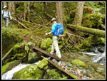 Walking The Plank |
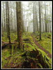 Misty Forest |
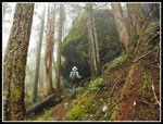 Big Rock |
 Getting Brushy |
 Lunch Break In Heaven |
 Cow Heaven |
 Heather |
 Partridge Foot |
 Heading For Ridge |
 Neat Clouds |
 Lupine |
 Falls Through Clouds |
 Cloudy Below |
 More Clouds |
 Ridge Top |
 Helen Buttes |
 Ridge Top Tarn |
 NE Helen Butte |
 SW Helen Butte |
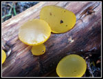 Bright Yellow |
 Final Meadow |
 Turnaround Point |
 Tarn & Butte Ridge |
 Climbing To Summit Ridge |
 Looking To False Summit |
 Looking Down Ridge |
 Grouse |
 Marsh Marigold |
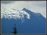
 Whitehorse Mountain |
 Heading Back |
 Back At Tarn |
 A Little Clearing |
 Valley Floor In Sight |
 Waterfall Again |
 More Peaks |
 View Northeast |
 Hidden Lake Lookout |
 Cow Heaven Below |
 Back In Forest |
 Mossy Rocks |
 Back At Last |
Trips - 2016
Home