10-22-16
Gwen
was free for a hike. The west side forecast was for rain. Sunny on the
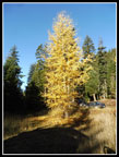
east side. The high elevation Lyall's larch were about finished. The
lower elevation Western larch were close to peak. We decided on a trip
up Miller Peak towards the eastern end of the NF Teanaway Valley. I
had been up Miller 12 times but had only come down the trail twice.
Most trips were a loop or via Iron or Shaser Creeks. This is a
motorcycle trail and a popular trail in hunting season. This was the
second and last weekend of general deer season. There would be lots of
hunters out. I have hiked the trail during hunting season a number of
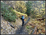
times and felt fine as long as I was draped in bright orange. Pam and
Jenny signed on too. I had not hiked with either of them before. We met
at 7:30 am in North Seattle and headed east.
The sky was clear east of the crest. Out to Cle Elum then up to the Teanaway Road. We had one mile of dirt before turning off onto Stafford Creek Road. In the 24 days since I drove to the Ingalls trailhead the road has deteriorated badly. The occasional pot holes then are almost continuous now. The Stafford Road is usually rocky and bad but it is now better than the main Teanaway Road. Hunters filled up 29 Pines Campgrounds and most of the unofficial sites along the Stafford Road. The Stafford Creek trailhead had only half a dozen cars. At the end of the road we found almost every spot taken around the parking loop. Several big tents and camps for hunters. We arrived at the 3200' trailhead at 9:40 am. It was chilly but well above freezing. There was a little frost apparent. We were on the trail by 9:54 am.
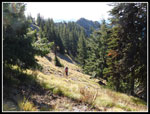
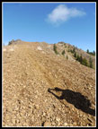
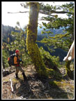
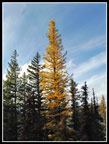
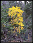
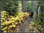
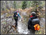
The trail to the summit gains 3200' over 4.25 miles. The first two miles gain elevation slowly. The last part is much steeper. There are a couple bigger creek crossings and several more easier ones. These were very easy with low water levels just a few weeks ago. Recent rains have brought up those levels. The wider ones had narrow logs that got us across. I had dry feet all day. Lots of yellow leaves along the lower trail. After about two miles the grade dramatically increased. There are no steps, roots or rocks on the trail. It is a very steady grade. The fact that there are lots of motorcycles does mean some short rocky sections.
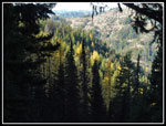
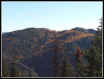
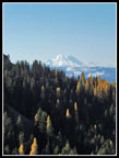
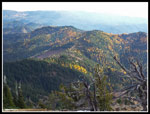
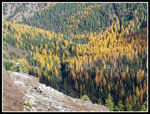
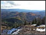
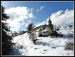
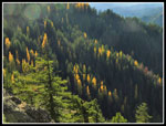
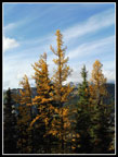
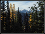
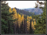
As we climbed the switchbacks we heard the sound of motorcycles. A few minutes later they passed by. As usual most of our encounters during the trip were fine. We got off the trails and the cycles slowed down and went by. No problems but a little exhaust smell and that passed quickly. We saw one or two motorcycles parked just off the trail. Not very many signs of hunters. We reached the first ridge top and had views east to Iron Bear Peak. The hillsides were awash in golden larch trees. They were right about at their peak. Blue sky and golden larch make for quite the view. Another group of motorcycles went by then we met two hikers coming down already. They mentioned that the trail was snow free all the way to the top. I did not expect that. We brought gaiters and microspikes and there was no snow.
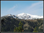
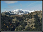
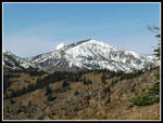
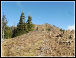
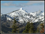
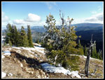
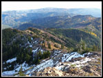
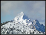
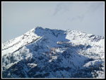
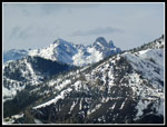
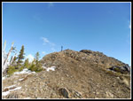
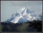
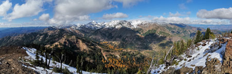
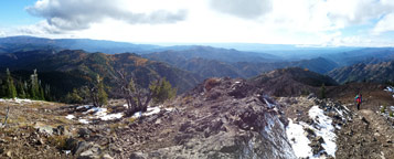
Higher up we met another group of hikers coming down. Pam knew one of them. The junction with the County Line Trail and the Miller summit route was unsigned. Down goes the County Line. Up goes the summit trail. Up we went. Now we had better views. Out to Earl, Navaho, and Three Brothers plus the top of Mt. Stuart. The last bit is wide open and a bit steeper. Just below the summit were all those motorcycles. I went on by and reached the 6400' top soon after at 1:08 pm. There was nobody else on top. The others were busy taking photos below as I bundled up. The first thing that was clear is that in a very short period the totally blue sky became more than half white. I have never seen clouds come in so fast. Unlike most of my visits to Miller the wind was not blowing hard on top. It was chilly but not too bad.
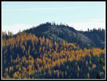
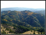
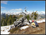
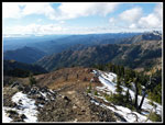
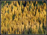
Great views in all directions from the summit of Miller. Mt. Stuart was in and out of clouds but most other summits were in the clear. Below the summit on the north side was snow and some larch trees. A few smaller trees right near the top had rime ice on them. By the time we headed down most all the rime ice had melted. Soon after I arrived on top all the motorcycles left. Gwen, Pam, and Jenny arrived soon after. After seeing a number of folks on the way up we had total solitude for nearly our entire time at the summit. A little later, I headed over to the northeast end of the summit ridge. Below was a very big grove of golden larch. The thickest grove I saw all day. Very nice.
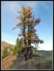
Two more hikers arrived more than an hour later. They came up via the Iron Creek Trail. A fun route and a long way back for them before dark. We finally packed up and headed down at 2:50 pm. Almost two hours on top. We saw a lot few folks on our way down. We did see a few groups still heading up. That was about it. We took one detour to get a closer look at a few big larch trees. We did stop for some photos but made much better time coming down. It was about 5:25 pm when we reached the car. Sunset was at 6:03 pm so we had half an hour to spare.
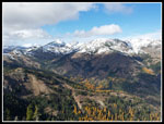
This is one of my favorite times of the year when the weather cooperates. We were able to hike up to 6400' without snow but all the higher peaks around us were covered with a fresh coating of snow. The sun really lit up the peaks. In addition, we had bright golden larch trees. Quite the double feature. I enjoyed another trip with Gwen and meeting and hiking with Jenny and Pam too. A great day in the high country. Soon it will require snowshoes.
Click on thumbnails to get
larger pictures.
Trips - 2016
Home
The sky was clear east of the crest. Out to Cle Elum then up to the Teanaway Road. We had one mile of dirt before turning off onto Stafford Creek Road. In the 24 days since I drove to the Ingalls trailhead the road has deteriorated badly. The occasional pot holes then are almost continuous now. The Stafford Road is usually rocky and bad but it is now better than the main Teanaway Road. Hunters filled up 29 Pines Campgrounds and most of the unofficial sites along the Stafford Road. The Stafford Creek trailhead had only half a dozen cars. At the end of the road we found almost every spot taken around the parking loop. Several big tents and camps for hunters. We arrived at the 3200' trailhead at 9:40 am. It was chilly but well above freezing. There was a little frost apparent. We were on the trail by 9:54 am.
The trail to the summit gains 3200' over 4.25 miles. The first two miles gain elevation slowly. The last part is much steeper. There are a couple bigger creek crossings and several more easier ones. These were very easy with low water levels just a few weeks ago. Recent rains have brought up those levels. The wider ones had narrow logs that got us across. I had dry feet all day. Lots of yellow leaves along the lower trail. After about two miles the grade dramatically increased. There are no steps, roots or rocks on the trail. It is a very steady grade. The fact that there are lots of motorcycles does mean some short rocky sections.
As we climbed the switchbacks we heard the sound of motorcycles. A few minutes later they passed by. As usual most of our encounters during the trip were fine. We got off the trails and the cycles slowed down and went by. No problems but a little exhaust smell and that passed quickly. We saw one or two motorcycles parked just off the trail. Not very many signs of hunters. We reached the first ridge top and had views east to Iron Bear Peak. The hillsides were awash in golden larch trees. They were right about at their peak. Blue sky and golden larch make for quite the view. Another group of motorcycles went by then we met two hikers coming down already. They mentioned that the trail was snow free all the way to the top. I did not expect that. We brought gaiters and microspikes and there was no snow.
Higher up we met another group of hikers coming down. Pam knew one of them. The junction with the County Line Trail and the Miller summit route was unsigned. Down goes the County Line. Up goes the summit trail. Up we went. Now we had better views. Out to Earl, Navaho, and Three Brothers plus the top of Mt. Stuart. The last bit is wide open and a bit steeper. Just below the summit were all those motorcycles. I went on by and reached the 6400' top soon after at 1:08 pm. There was nobody else on top. The others were busy taking photos below as I bundled up. The first thing that was clear is that in a very short period the totally blue sky became more than half white. I have never seen clouds come in so fast. Unlike most of my visits to Miller the wind was not blowing hard on top. It was chilly but not too bad.
Great views in all directions from the summit of Miller. Mt. Stuart was in and out of clouds but most other summits were in the clear. Below the summit on the north side was snow and some larch trees. A few smaller trees right near the top had rime ice on them. By the time we headed down most all the rime ice had melted. Soon after I arrived on top all the motorcycles left. Gwen, Pam, and Jenny arrived soon after. After seeing a number of folks on the way up we had total solitude for nearly our entire time at the summit. A little later, I headed over to the northeast end of the summit ridge. Below was a very big grove of golden larch. The thickest grove I saw all day. Very nice.
Two more hikers arrived more than an hour later. They came up via the Iron Creek Trail. A fun route and a long way back for them before dark. We finally packed up and headed down at 2:50 pm. Almost two hours on top. We saw a lot few folks on our way down. We did see a few groups still heading up. That was about it. We took one detour to get a closer look at a few big larch trees. We did stop for some photos but made much better time coming down. It was about 5:25 pm when we reached the car. Sunset was at 6:03 pm so we had half an hour to spare.
This is one of my favorite times of the year when the weather cooperates. We were able to hike up to 6400' without snow but all the higher peaks around us were covered with a fresh coating of snow. The sun really lit up the peaks. In addition, we had bright golden larch trees. Quite the double feature. I enjoyed another trip with Gwen and meeting and hiking with Jenny and Pam too. A great day in the high country. Soon it will require snowshoes.
 Trailhead Color |
 Gwen On The Trail |
 Little Larch |
 Window To Larch Color |
 Earl Peak |
 Iron Bear Color |
 Closer Look |
 Earl & Clouds |
 Mt. Rainier |
 Navaho Peak |
 Grassy Trail |
 Lots Of Larch |
 Summit In Sight |
 Iron Bear & Jester Pks |
 Big Shadow |
 Silver Snag |
 Pam At Work |
 Navaho & Stuart |
 Cycles Below Summit |
 Route Below Summit |
 Navaho & Three Brothers |
 Rime Ice |
 Lit Up Larch |
 Big Larch Forest |
 Ridge On Loop Trip |
 Peaking Larch |
 Sea Of Larch |
 Snowy Back Side |
 Clouds Around Stuart |
 Snowy Earl Peak |
 Ingalls Peaks |
 Leaving Summit |
 Pam & Mossy Tree |
 Sun Lit Larch |
 Lone Larch |
 More Larch |
 Dramatic Mt. Stuart |
 Framed Earl Peak |
 Big Larch |
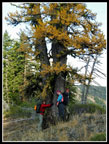 Tree Huggers |
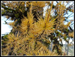 Larch Needles |
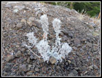 White Plant |
 Window Of Larch |
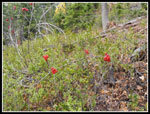 Mountain Ash |
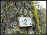 2 Mile Marker |
 More Leaf Color |
 Lined With Yellow |
 Creek Crossing |
 Panorama of the Teanaway Peaks |
 Panorama Looking To The East And South |
Trips - 2016
Home