3-05-16
It
is now official. The period from December through February was the
wettest on record for Seattle. Now we are in March and I was looking
at another wet day in the mountains with the snow level at 5000'.
Being in the rain on snow sucks. I chose a lower elevation
away from the mountains. So many winter trips have been along I-90 near
Seattle and I wanted to go somewhere different. I hike on Blanchard
Hill just about every year. I missed 2015 entirely. Clearly it was time
for another visit. I headed out of Seattle at a somewhat late time of
8:15 am. The sky was bright blue. To the east it was dark and
gray. I headed north nearly to Bellingham and took the Alger exit. A
left turn then another quick on on Barrell Springs Road. A right at the
signed wide dirt road to Blanchard Hill Trails. I passed the lower
trailhead and went up to the upper lot. There were half a dozen cars
there. I packed up and was on my way by 9:30 am.
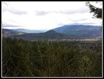
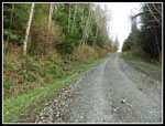
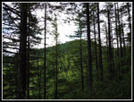
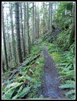
Last time I went clockwise. This time I reversed it and started up the old gated road. After 65 miles of sunshine on the drive I entered the cloud zone as I reached Blanchard Hill. I still harbored hopes that it might clear up later on. Part way up is an old barrow pit. A wide spot where the hill was dug away. It was mostly covered in small trees and brush on my last visit. Now it has been completely cleared out. Across from it is a break in the trees and views east. I could not see Mt. Baker this day but I could see out to farms below. After a little more than a mile I reached the Alternate Incline Trail. Time to leave the road. My usual route is an 8 mile route that is mostly a loop with an in an out from Lily Lake to Oyster Dome. This day I wanted to make it longer and determined a route as I headed up the trail.
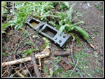
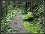
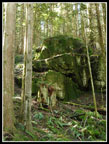
There are bits and pieces of old logging history on the way up. It has rusted cables, bits of equipment, and railroad grades. On my first visit the old Incline Trail was still in existence. The Alternate Incline was an alternative. I can still find the upper and lower ends of the old shorter steeper trail but it is rapidly disappearing. I took a short break at the junction with the Pacific Northwest Trail (PNT). I usually go right to Lizard Lake. This day I headed left on the trail to Lily Lake. The grade is pretty flat. It did not take long to reach the junction with the Lily Lake Trail. That would be my route down to my car at the upper trailhead. A few minutes farther down the trail I reached the junction with the side trail to Lily Lake, North Butte, and Lizard Lake. I would be taking that one a little later.
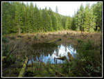
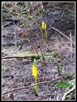
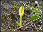
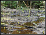
The marsh here is a spot that always has skunk cabbage in the spring. It is still very early March so I was not expecting any yellow. Perhaps a few green stalks poking above the water. To my surprise, They were already up and bright yellow. Not yet at their peak but well on their way. While stopped for photos Opus (David) and Lindsey approached. They had been to Oyster Dome already. I've done many hikes with David over the years. Always fun to unexpectedly meet someone on the trail. They headed off to Lily Lake and I headed for Oyster Dome. They were the first folks I had seen all day. Even with the recent rain the creek crossings were easy. The muddy spots were also not bad. I dropped down and at the junction with the Oyster Dome Trail coming up from Chuckanut Drive I began to see hikers. It did not take long to hike up to Oyster Dome from there.
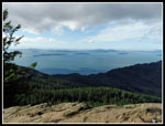
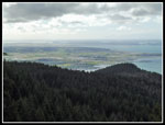
The route up is in forest. I could hear the wind but felt little. I did notice that every person coming down had jackets zipped up and hoods tied down tightly. That was a little clue to the conditions. Near the top I stopped to put on my jacket. I was prepared when I stepped onto the open rocks with everyone else. There is almost always "everyone else". Oyster Dome has become very popular. It is to be expected. There were still some clouds overhead but there was also some patches of sunshine too. I have been up there a number of times with nearly zero views. This was one of the clearer days I have had. I took lots of photos and had lunch before I headed up to the actual summit nearby. On the way down the slightly lower rocky slabs now had no people there. It provided even better views to the south.
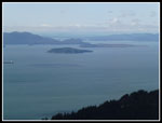
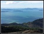
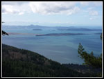
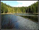
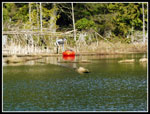
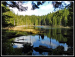
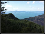
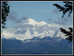
I passed many groups heading up in the short section back to the Oyster Dome Trail junction. I left most of the crowds and retraced my steps back to the Lily Lake junction by the skunk cabbages. At Lily Lake I found two groups in the camping area though not camping. One person was out on the lake in a boat. A few photos and I was heading to North Butte. Since my last visit the DNR folks have put up a lot of trail signs. There is even one at Lily Lake pointing towards North Butte and Lizard Lake. I turned off for the short steep climb to North Butte. It was windy on top. Oyster Butte is in site then salt water and the San Juan Islands. Two other hikers arrived as I left. Though it was cloudier to the east I went over to the north viewpoint and was surprised to be able to see Mt. Baker with just a few clouds around it.
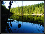
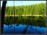
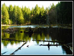
Now it was down hill to Lizard Lake. I went to the far end of the lake and back to the near end. There were just a few skunk cabbage poking above the water. A short walk took me to the Alternate Incline - PNT junction once again. A second trip along the railroad grade on the PNT and I was back at the Lily Lake Trail junction. Now it was time for the descent to the trailhead. The sun was really coming out and it warmed quickly as I descended. Short sleeves at first and I zipped off the legs too. It started to feel like spring. I did not see any yellow violets or other spring wildflowers out but it won't be long now. By 2:40 I was back at my car. There were quite a few more cars now though the lot was not filled.
For the day I hiked 10 miles with 2100' of elevation gain. More than three quarters of all the people I saw all day were in the short distance to and from Oyster Dome from the busier trail's junction. Otherwise I had quite a bit of solitude. There was wind up high and clouds in the morning but all in all it was one of the better weather days I have had on this trail. The days are getting longer now. I was home hours before dark. This is a nice alternative to Tiger and Cougar Mountains for a snow free winter trip. I doubt I'll miss a year again anytime soon.
Click on thumbnails to get
larger pictures.
Trips - 2016
Home
Last time I went clockwise. This time I reversed it and started up the old gated road. After 65 miles of sunshine on the drive I entered the cloud zone as I reached Blanchard Hill. I still harbored hopes that it might clear up later on. Part way up is an old barrow pit. A wide spot where the hill was dug away. It was mostly covered in small trees and brush on my last visit. Now it has been completely cleared out. Across from it is a break in the trees and views east. I could not see Mt. Baker this day but I could see out to farms below. After a little more than a mile I reached the Alternate Incline Trail. Time to leave the road. My usual route is an 8 mile route that is mostly a loop with an in an out from Lily Lake to Oyster Dome. This day I wanted to make it longer and determined a route as I headed up the trail.
There are bits and pieces of old logging history on the way up. It has rusted cables, bits of equipment, and railroad grades. On my first visit the old Incline Trail was still in existence. The Alternate Incline was an alternative. I can still find the upper and lower ends of the old shorter steeper trail but it is rapidly disappearing. I took a short break at the junction with the Pacific Northwest Trail (PNT). I usually go right to Lizard Lake. This day I headed left on the trail to Lily Lake. The grade is pretty flat. It did not take long to reach the junction with the Lily Lake Trail. That would be my route down to my car at the upper trailhead. A few minutes farther down the trail I reached the junction with the side trail to Lily Lake, North Butte, and Lizard Lake. I would be taking that one a little later.
The marsh here is a spot that always has skunk cabbage in the spring. It is still very early March so I was not expecting any yellow. Perhaps a few green stalks poking above the water. To my surprise, They were already up and bright yellow. Not yet at their peak but well on their way. While stopped for photos Opus (David) and Lindsey approached. They had been to Oyster Dome already. I've done many hikes with David over the years. Always fun to unexpectedly meet someone on the trail. They headed off to Lily Lake and I headed for Oyster Dome. They were the first folks I had seen all day. Even with the recent rain the creek crossings were easy. The muddy spots were also not bad. I dropped down and at the junction with the Oyster Dome Trail coming up from Chuckanut Drive I began to see hikers. It did not take long to hike up to Oyster Dome from there.
The route up is in forest. I could hear the wind but felt little. I did notice that every person coming down had jackets zipped up and hoods tied down tightly. That was a little clue to the conditions. Near the top I stopped to put on my jacket. I was prepared when I stepped onto the open rocks with everyone else. There is almost always "everyone else". Oyster Dome has become very popular. It is to be expected. There were still some clouds overhead but there was also some patches of sunshine too. I have been up there a number of times with nearly zero views. This was one of the clearer days I have had. I took lots of photos and had lunch before I headed up to the actual summit nearby. On the way down the slightly lower rocky slabs now had no people there. It provided even better views to the south.
I passed many groups heading up in the short section back to the Oyster Dome Trail junction. I left most of the crowds and retraced my steps back to the Lily Lake junction by the skunk cabbages. At Lily Lake I found two groups in the camping area though not camping. One person was out on the lake in a boat. A few photos and I was heading to North Butte. Since my last visit the DNR folks have put up a lot of trail signs. There is even one at Lily Lake pointing towards North Butte and Lizard Lake. I turned off for the short steep climb to North Butte. It was windy on top. Oyster Butte is in site then salt water and the San Juan Islands. Two other hikers arrived as I left. Though it was cloudier to the east I went over to the north viewpoint and was surprised to be able to see Mt. Baker with just a few clouds around it.
Now it was down hill to Lizard Lake. I went to the far end of the lake and back to the near end. There were just a few skunk cabbage poking above the water. A short walk took me to the Alternate Incline - PNT junction once again. A second trip along the railroad grade on the PNT and I was back at the Lily Lake Trail junction. Now it was time for the descent to the trailhead. The sun was really coming out and it warmed quickly as I descended. Short sleeves at first and I zipped off the legs too. It started to feel like spring. I did not see any yellow violets or other spring wildflowers out but it won't be long now. By 2:40 I was back at my car. There were quite a few more cars now though the lot was not filled.
For the day I hiked 10 miles with 2100' of elevation gain. More than three quarters of all the people I saw all day were in the short distance to and from Oyster Dome from the busier trail's junction. Otherwise I had quite a bit of solitude. There was wind up high and clouds in the morning but all in all it was one of the better weather days I have had on this trail. The days are getting longer now. I was home hours before dark. This is a nice alternative to Tiger and Cougar Mountains for a snow free winter trip. I doubt I'll miss a year again anytime soon.
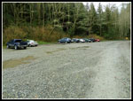 Upper Trailhead |
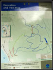 Blanchard Hill Map |
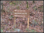 New Signs |
 First Viewpoint |
 Leaving Road |
 Logging Gear |
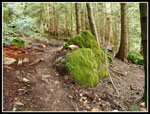
 Mossy Goodness |
 Wetland |
 Skunk Cabbage |
 Oyster Dome View |
 Islands |
 Clearing Up |
 North Butte |
 View Southwest |
 Skagit Lowlands |
 Perfect Skunk Cabbage |
 Lots Of Skunk Cabbage |
 Lily Lake |
 Boat & Boater |
 Nice Color |
 Mossy Rock |
 OD From North Butte |
 Mt. Baker |
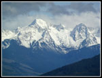 Snowy Peaks |
 Big Rock |
 Lizard Lake Color |
 Lizard Lake II |
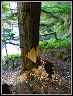 Beavers At Work |
 From Near Outlet |
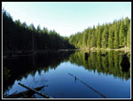 Lizard Reflection |
 Lily Lake Trail |
 Almost Down |
Trips - 2016
Home