2-28-16
A
damp gray late February day is a good time to explore a new trail close
to Seattle.
I was aware that land was purchased just a few years ago and a trail
was built to connect up with the many others on Squak Mountain. I just
had not taken a look at any information about it. A few days earlier
John had decided to check it out. That brought it back onto my radar
screen. With a crummy forecast for Saturday a short drive to a new
trail sounded good. It was easy to find out about it. Take the Highway
900 exit at the west end of Issaquah and proceed 3.2 miles south. The
entrance is hard to see at 40 mph. It is just south of the Wilderness
Peak trailhead for Cougar Mountain. The site is an old campground.
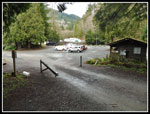
Complete with office and fenced basketball court near the entrance.
There are 23 marked parking spaces and room for a few more. I did not
get out for an early start. It was 9:30 when I started out.
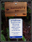
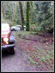
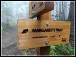
There is a road to the left of the parking lot. Not the right way. There is a sign board and road to the right. That's the way. A short way up the gravel road is a sign pointing left for Margret's Way Trail. The dirt trail starts a short way along. The trail climbs above the gravel road. I only went a short way when the trail reaches the road once again. Unfortunately, there was a mini van blocking the way. Completely blocking the trail. Right from the cut bank on the left to the drop off on the right. He was stuck. I had to go backwards to find a spot to get up the bank. I have never had to bushwhack on a dirt trail to get around a car. A first time for everything. As I got onto the road a jeep arrived to tow the stuck van away. The van must have tried to turn around when he became stuck.
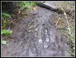
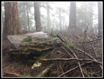
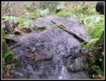
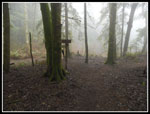
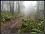
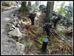
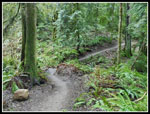
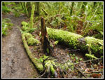
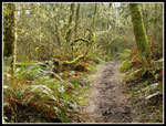
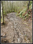
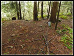
The route is a combination of trail and old road in the first mile. The campground went well up the hillside. I passed quite a few of the old campsites. They had electric hookups too. At long last, the road came to an end and I was on the new trail. In addition to a number of road junctions there are old trails and spur roads that branch off the trail. They all have signs pointing out the correct route. As the new route gets beaten in the junctions are getting to be easy to figure out. One thing I noticed in most all the trip reports I read was mention of the mud. For that reason I wore my heavier waterproof boots. It was a good decision. Much of the elevation gain is in the last mile. The middle is flatter. This is where the mud is "challenging". In the summer it will dry out. Now it is very slick. If keeping your feet dry is not a concern then trail runners will do fine. The mud is generally not deep, just wet and slick.
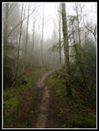
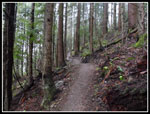
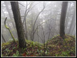
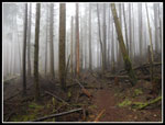
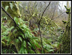
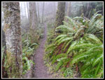
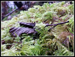
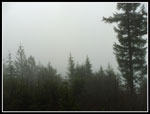
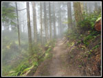
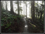
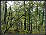
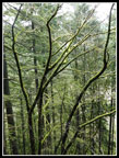
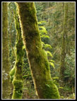
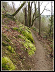
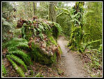
I was glad when the grade steepened. The traction improved. In Seattle there were high clouds. In Issaquah the clouds were near ground level. The hike up was totally in clouds. Visibility was minimal. At times it was almost wet enough to pull out my umbrella. The mist and all the moss made for some good photos. I passed a few folks early on heading down. After that there was solitude. After the mud the steeper section is in great shape. No trees down though a few were cut out recently. There is one murky spot where I almost buried my high top boots in mud. Otherwise the tread is fine. I reached the top of the trail where it meets the Chybinski Trail. The sign states that it is 2.76 miles. John's edited GPS track and my gut says it is actually about three miles. I turned right and thirty seconds later I reached a junction that I recognized.
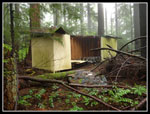
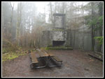
At the four way junction I took the middle trail. This one goes up and over West Peak. The mist was really heavy up there. Almost umbrella time. At the top are the flattened remains of an old building. It was still standing, minus the roof, on my first visit in 2010. From the summit I dropped down to the junction at the top of the Bullitt Gorge Trail. Here I met two hikers looking for the Bullitt cabin site and chimney. A few steps later I was on the Bullitt Chimney Trail heading for it. The other folks followed behind. I made a stop for some photos at the chimney. The other hikers followed me out. I was headed to Central Peak via the down and up trails. I mentioned the shortcut trail along the ridge. I made good time over to Central Peak and arrived just as the other hikers popped out from the ridge top trail. It was very misty on top.
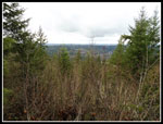
I retraced my steps back to the Bullitt Gorge - West Peak junction. I chose to take the route John did a few days earlier. I dropped down the Gorge Trail. This is the route I often take from the State Park trailhead at the south end of Squak Mountain. When I reached the Perimeter Loop Trail I turned off to the right. This is the second trail I was hiking for the first time. The trail does a slow ascent as it cuts around the southwest side of the mountain. At the junction for the short trail to Debbies View I took it. At the viewpoint I met a group I had seen over near Central Peak earlier. The view was non existent. Gray clouds and nothing else. Well, I guess I'll have to come back on a clear day. From there it was just a short hike to the four way junction where I earlier headed up West Peak.
A minute later I was on Margaret's Way Trail heading down. As I descended the mist began to fade away. At times there was even a little sunshine. It was still chilly but no longer damp. Near the end of the upper trail there is a signed viewpoint. On the way up I had zero view. Now I could see out a little. Back in the campground I met a few groups heading up. At the spot where the van was stuck it was gone but the ground was torn up. Though a squall was near by I made it down dry. I hike on Squak Mountain a time or two each year. One usual route leaves from the south and another from the east side. Now I have a third trailhead to use. I like this trail. Yes, it's a little muddy but otherwise it is nicely graded and opens up another area of Squak for hiking. I will probably hike this trail one or twice a year as a close in alternative. It was a fun day on the trail.
Click on thumbnails to get
larger pictures.
Trips - 2016
Home
There is a road to the left of the parking lot. Not the right way. There is a sign board and road to the right. That's the way. A short way up the gravel road is a sign pointing left for Margret's Way Trail. The dirt trail starts a short way along. The trail climbs above the gravel road. I only went a short way when the trail reaches the road once again. Unfortunately, there was a mini van blocking the way. Completely blocking the trail. Right from the cut bank on the left to the drop off on the right. He was stuck. I had to go backwards to find a spot to get up the bank. I have never had to bushwhack on a dirt trail to get around a car. A first time for everything. As I got onto the road a jeep arrived to tow the stuck van away. The van must have tried to turn around when he became stuck.
The route is a combination of trail and old road in the first mile. The campground went well up the hillside. I passed quite a few of the old campsites. They had electric hookups too. At long last, the road came to an end and I was on the new trail. In addition to a number of road junctions there are old trails and spur roads that branch off the trail. They all have signs pointing out the correct route. As the new route gets beaten in the junctions are getting to be easy to figure out. One thing I noticed in most all the trip reports I read was mention of the mud. For that reason I wore my heavier waterproof boots. It was a good decision. Much of the elevation gain is in the last mile. The middle is flatter. This is where the mud is "challenging". In the summer it will dry out. Now it is very slick. If keeping your feet dry is not a concern then trail runners will do fine. The mud is generally not deep, just wet and slick.
I was glad when the grade steepened. The traction improved. In Seattle there were high clouds. In Issaquah the clouds were near ground level. The hike up was totally in clouds. Visibility was minimal. At times it was almost wet enough to pull out my umbrella. The mist and all the moss made for some good photos. I passed a few folks early on heading down. After that there was solitude. After the mud the steeper section is in great shape. No trees down though a few were cut out recently. There is one murky spot where I almost buried my high top boots in mud. Otherwise the tread is fine. I reached the top of the trail where it meets the Chybinski Trail. The sign states that it is 2.76 miles. John's edited GPS track and my gut says it is actually about three miles. I turned right and thirty seconds later I reached a junction that I recognized.
At the four way junction I took the middle trail. This one goes up and over West Peak. The mist was really heavy up there. Almost umbrella time. At the top are the flattened remains of an old building. It was still standing, minus the roof, on my first visit in 2010. From the summit I dropped down to the junction at the top of the Bullitt Gorge Trail. Here I met two hikers looking for the Bullitt cabin site and chimney. A few steps later I was on the Bullitt Chimney Trail heading for it. The other folks followed behind. I made a stop for some photos at the chimney. The other hikers followed me out. I was headed to Central Peak via the down and up trails. I mentioned the shortcut trail along the ridge. I made good time over to Central Peak and arrived just as the other hikers popped out from the ridge top trail. It was very misty on top.
I retraced my steps back to the Bullitt Gorge - West Peak junction. I chose to take the route John did a few days earlier. I dropped down the Gorge Trail. This is the route I often take from the State Park trailhead at the south end of Squak Mountain. When I reached the Perimeter Loop Trail I turned off to the right. This is the second trail I was hiking for the first time. The trail does a slow ascent as it cuts around the southwest side of the mountain. At the junction for the short trail to Debbies View I took it. At the viewpoint I met a group I had seen over near Central Peak earlier. The view was non existent. Gray clouds and nothing else. Well, I guess I'll have to come back on a clear day. From there it was just a short hike to the four way junction where I earlier headed up West Peak.
A minute later I was on Margaret's Way Trail heading down. As I descended the mist began to fade away. At times there was even a little sunshine. It was still chilly but no longer damp. Near the end of the upper trail there is a signed viewpoint. On the way up I had zero view. Now I could see out a little. Back in the campground I met a few groups heading up. At the spot where the van was stuck it was gone but the ground was torn up. Though a squall was near by I made it down dry. I hike on Squak Mountain a time or two each year. One usual route leaves from the south and another from the east side. Now I have a third trailhead to use. I like this trail. Yes, it's a little muddy but otherwise it is nicely graded and opens up another area of Squak for hiking. I will probably hike this trail one or twice a year as a close in alternative. It was a fun day on the trail.
 Trail Sign |
 Stuck Car |
 Campsite 29 |
 Trail Markers |
 Misty Trail |
 Muddy Spot |
 Mossy Log |
 No Underbrush |
 A Long Way Down |
 Building Remains |
 Building In 2010 |
 Bullitt Chimney |
 Bullitt Gorge Junction |
 Moss & Ferns |
 More Mud |
 Perimeter Loop Trail |
 Mossy Goodness |
 Debbies View |
 4 Way Junction |
 Top Of Margaret's Way |
 More Mist |
 Some Sun? |
 Neat Lighting |
 Huh?? |
 Shades Of Green |
 Mossy Deciduous Trees |
 New Trail |
 More Mossy Logs |
 Licorice Ferns |
 On The Flats |
 Muddiest Spot |
 Mossy Rocks |
 Lower Viewpoint |
 Campsite |
 Old Sign |
 Neat Colors |
 Parking Lot |
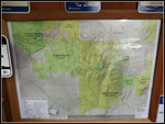 Map |
Trips - 2016
Home