4-16-17
With
a sunny day on tap I wanted to
get in some miles and not slog in snow. It was Easter Sunday and I
chose to head north. For the last two years I have done a loop hike on
Chuckanut Mountain. Wildflowers, views, a lake, and the Rock Trail.
Plenty to keep me busy for a day of hiking. Time for another visit. In
addition to Easter it was also a peak weekend for the Skagit valley
tulip fields. Perhaps the trails would be pretty empty? I headed out at
7:05 am. One stop for gas and I headed for Bellingham. Well, almost to
Bellingham. Off I-5 at exit 246 and then on the Old Samish Road to
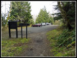
Chuckanut Drive. There were only a few cars in the lot when I arrived.
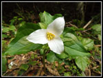
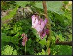
I packed up and I was on the trail at 8:42 am. Two days earlier I saw
my first salmonberry flowers and yellow violets of the season as well
as many trillium. I still had not seen any bleeding hearts. 75 feet up
the trail I found a big patch of blooming bleeding hearts. They were
the only bleeding hearts I saw all day. Lots of plants but no more in
bloom.
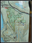
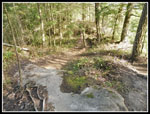
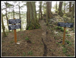
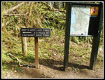
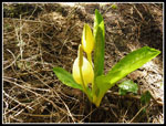
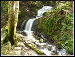
There were also a lot of skunk cabbage in the first mile. Most were a little past prime but some yellow still remained. In just a few short minutes the trail intersects the Interurban Trail. This old intercity train line opened for business 105 years ago as the Bellingham and Skagit Interurban. Today it is a recreational trail where it still exists. The route passes a nice waterfall right along the way. Once it turned and crossed the gorge of Chuckanut Creek. That bridge was 700 feet long and 130 feet high. All that remains is a concrete footing. The trail soon splits at an unsigned junction. Down goes to Arroyo Park. I took that route the first two times. Up is a shorter route and I took it this time. Most all the other junctions on the route were signed. Many had full sized maps on boards. Those maps were not there last year.
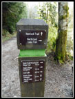
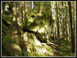
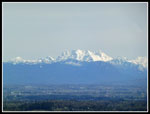
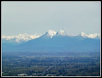
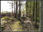
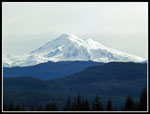
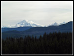
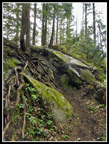
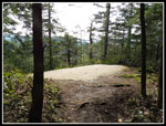
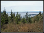
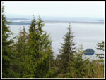
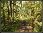
The trail is wide and a few switchbacks have banked dirt turns. Looks like this is a mountain bike speedway. This Easter day it was very quiet. I did not see a bike until I was within a few miles of the end. I did not see all that many people at all. I was on the Hemlock Trail and stayed on it until a right turn onto the North Lost Lake Trail. In a few weeks the bleeding hearts and yellow violets will line the route. For now it is just green. The next junction was the start of my look. At 2.2 miles in I reached the Chuckanut Ridge Trail. It sweeps around the nose of the ridge passing some big boulders. It then climbs a short steep section up to the ridge top. Not long after the first views of Mt. Baker open up. The ridge top is entirely forested blocking most all views west to salt water. There are a number of opening to the east providing mountain views. Baker and the Twin Sisters were covered with winter snow.
It was all blue sky when I started but high clouds were drifting in. It was pleasantly warm but Mt. Baker surrounded by blue sky never happened. Good views but not the best. I'd forgotten how long that ridge is. Also all the ups and downs. The high point of the trip was 1940' but I logged 2700' of gain. Yep, lots of ups and downs. There are two trails that drop down to roads coming off of Chuckanut Drive to the west. On my first trip I accidentally took the second one and had to climb back up. The ridge is narrow in spots. There are a couple spots where hands are needed to for short scrambles up slabs of rock and steep dirt. I was a little disappointed to see deep bike tire tracks along the whole ridge. I wish this one trail was a bike free zone. At least in the rainy season. I did not see any up there this day.
After three miles of ridge I finally popped out of the forest just before the Cyrus Gates overlook. Yes, you can drive all the way to the top. On my first two visits I took the short road route to the overlook. This time I stayed on a trail that climbed the ridge to the top of Chuckanut Mountain. At 1940' the summit is about 100' above the overlook. The top is completely forested. No views. I found a trail that took me down to the overlook. It was 11:17 when I arrived. I took 2:35 to hike about 5.25 miles. Trees are growing up and beginning to interfere with the views. The view remains but seems to be shrinking with each visit. My lunch break was just under 20 minutes. Now it was time for one of the best parts of the trip.
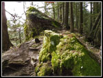
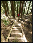
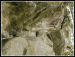
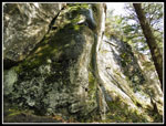
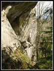
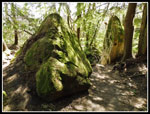
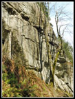
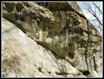
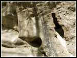
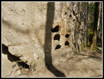
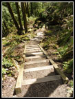
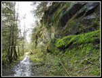
The Rock Trail is almost exactly three years old. It was dedicated on April 26,2014. My first visit was only a year later. A short forest walk from the overlook takes you to the stairs. Staircases were built on an impossibly steep slope. Unlike any trail I've hiked around here. Significant elevation is lost very fast. Then you are back on dirt trail once again. this side of Chuckanut Mountain is exposed sandstone. Near vertical cliffs of sandstone. I see very little of it hiking in Washington state. This and Exclamation Point Rock are prime examples. The rock is hard to describe so just look at the photos below the report. I did run into several groups hiking up the trail but none hiking down. The trail does a good job of skirting the bottom of the sandstone cliffs. Lots of craning my neck to see to the top. It is 1.2 miles down to the bottom. With all the photos it took me 50 minutes. The trail descends 1200' in that 1.2 miles. Those stairways account for a good portion.
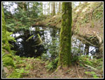
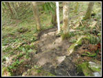
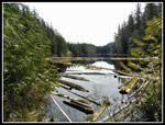
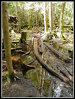
At the bottom it was wet enough for more skunk cabbage. I went left on the North Lost Lake Trail. The same one that I hiked the north part of in the morning. It would take me much of the way back. It traverses above long narrow Lost Lake. I could see a little of it below through the trees. At the other end of the lake is a side trail to the outlet. I was hiking with low top hiking shoes and no poles. There is some mud and running water to cross. It can be interesting. A number of narrow logs have been placed at the worst spot. Easy to cross with poles. I managed to not fall in while crossing and recrossing. Forest goes right to the edge of the lake making photos difficult. I found a few spots where I could get a view down the lake. It had been a little chilly up at the overlook but down at the lake it was pleasantly warm.
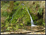
I ran into several groups at the lake. My stay was short. Soon I was back on the North Lost Lake Trail. This trail sits right below Chuckanut Ridge. The slope is near vertical. In places there are more sandstone cliffs. There are also a few small waterfalls next to the trail. The trail was once a gravel road so it is not as nice as dedicated trails nearby but it is still nice hiking. I started seeing blooming trillium along the trail. Also a few mushrooms. The route does hike a lot faster than the up and down ridge trail high above. I passed several other well marked trails. First was Raptor Ridge then the Madrone Crest Trail. More places for me to explore on future trips. The Raptor Ridge Trail continues over to Pine and Cedar Lakes. I visited them for the first time last year via a different route.
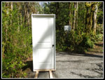
The next junction was the end of my loop. Back to where I headed off on the Chuckanut Ridge Trail. Now it was just 2.2 miles of downhill back to the trailhead. Along the way I passed a door on the trail. Standing up in a frame. A door. That was a first sighting on a hiking trail. I reached my car at 2:25 pm. My 11+ mile jaunt took 5:43. I was back by early afternoon. After the first 45 minutes it was short sleeves and shorts for the rest of the day. We are heading back to another rainy week ahead but for this one day it felt like spring. Hiking Chuckanut Mountain in the spring has become a habit and not one I will likely break any time soon.
Click on thumbnails to get
larger pictures.
Trips - 2017
Home
There were also a lot of skunk cabbage in the first mile. Most were a little past prime but some yellow still remained. In just a few short minutes the trail intersects the Interurban Trail. This old intercity train line opened for business 105 years ago as the Bellingham and Skagit Interurban. Today it is a recreational trail where it still exists. The route passes a nice waterfall right along the way. Once it turned and crossed the gorge of Chuckanut Creek. That bridge was 700 feet long and 130 feet high. All that remains is a concrete footing. The trail soon splits at an unsigned junction. Down goes to Arroyo Park. I took that route the first two times. Up is a shorter route and I took it this time. Most all the other junctions on the route were signed. Many had full sized maps on boards. Those maps were not there last year.
The trail is wide and a few switchbacks have banked dirt turns. Looks like this is a mountain bike speedway. This Easter day it was very quiet. I did not see a bike until I was within a few miles of the end. I did not see all that many people at all. I was on the Hemlock Trail and stayed on it until a right turn onto the North Lost Lake Trail. In a few weeks the bleeding hearts and yellow violets will line the route. For now it is just green. The next junction was the start of my look. At 2.2 miles in I reached the Chuckanut Ridge Trail. It sweeps around the nose of the ridge passing some big boulders. It then climbs a short steep section up to the ridge top. Not long after the first views of Mt. Baker open up. The ridge top is entirely forested blocking most all views west to salt water. There are a number of opening to the east providing mountain views. Baker and the Twin Sisters were covered with winter snow.
It was all blue sky when I started but high clouds were drifting in. It was pleasantly warm but Mt. Baker surrounded by blue sky never happened. Good views but not the best. I'd forgotten how long that ridge is. Also all the ups and downs. The high point of the trip was 1940' but I logged 2700' of gain. Yep, lots of ups and downs. There are two trails that drop down to roads coming off of Chuckanut Drive to the west. On my first trip I accidentally took the second one and had to climb back up. The ridge is narrow in spots. There are a couple spots where hands are needed to for short scrambles up slabs of rock and steep dirt. I was a little disappointed to see deep bike tire tracks along the whole ridge. I wish this one trail was a bike free zone. At least in the rainy season. I did not see any up there this day.
After three miles of ridge I finally popped out of the forest just before the Cyrus Gates overlook. Yes, you can drive all the way to the top. On my first two visits I took the short road route to the overlook. This time I stayed on a trail that climbed the ridge to the top of Chuckanut Mountain. At 1940' the summit is about 100' above the overlook. The top is completely forested. No views. I found a trail that took me down to the overlook. It was 11:17 when I arrived. I took 2:35 to hike about 5.25 miles. Trees are growing up and beginning to interfere with the views. The view remains but seems to be shrinking with each visit. My lunch break was just under 20 minutes. Now it was time for one of the best parts of the trip.
The Rock Trail is almost exactly three years old. It was dedicated on April 26,2014. My first visit was only a year later. A short forest walk from the overlook takes you to the stairs. Staircases were built on an impossibly steep slope. Unlike any trail I've hiked around here. Significant elevation is lost very fast. Then you are back on dirt trail once again. this side of Chuckanut Mountain is exposed sandstone. Near vertical cliffs of sandstone. I see very little of it hiking in Washington state. This and Exclamation Point Rock are prime examples. The rock is hard to describe so just look at the photos below the report. I did run into several groups hiking up the trail but none hiking down. The trail does a good job of skirting the bottom of the sandstone cliffs. Lots of craning my neck to see to the top. It is 1.2 miles down to the bottom. With all the photos it took me 50 minutes. The trail descends 1200' in that 1.2 miles. Those stairways account for a good portion.
At the bottom it was wet enough for more skunk cabbage. I went left on the North Lost Lake Trail. The same one that I hiked the north part of in the morning. It would take me much of the way back. It traverses above long narrow Lost Lake. I could see a little of it below through the trees. At the other end of the lake is a side trail to the outlet. I was hiking with low top hiking shoes and no poles. There is some mud and running water to cross. It can be interesting. A number of narrow logs have been placed at the worst spot. Easy to cross with poles. I managed to not fall in while crossing and recrossing. Forest goes right to the edge of the lake making photos difficult. I found a few spots where I could get a view down the lake. It had been a little chilly up at the overlook but down at the lake it was pleasantly warm.
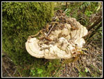
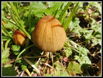
I ran into several groups at the lake. My stay was short. Soon I was back on the North Lost Lake Trail. This trail sits right below Chuckanut Ridge. The slope is near vertical. In places there are more sandstone cliffs. There are also a few small waterfalls next to the trail. The trail was once a gravel road so it is not as nice as dedicated trails nearby but it is still nice hiking. I started seeing blooming trillium along the trail. Also a few mushrooms. The route does hike a lot faster than the up and down ridge trail high above. I passed several other well marked trails. First was Raptor Ridge then the Madrone Crest Trail. More places for me to explore on future trips. The Raptor Ridge Trail continues over to Pine and Cedar Lakes. I visited them for the first time last year via a different route.
The next junction was the end of my loop. Back to where I headed off on the Chuckanut Ridge Trail. Now it was just 2.2 miles of downhill back to the trailhead. Along the way I passed a door on the trail. Standing up in a frame. A door. That was a first sighting on a hiking trail. I reached my car at 2:25 pm. My 11+ mile jaunt took 5:43. I was back by early afternoon. After the first 45 minutes it was short sleeves and shorts for the rest of the day. We are heading back to another rainy week ahead but for this one day it felt like spring. Hiking Chuckanut Mountain in the spring has become a habit and not one I will likely break any time soon.
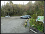 Parking Lot |
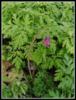 Bleeding Hearts |
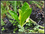 Skunk Cabbage |
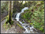 Waterfall |
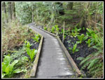 Boardwalk |
 New Maps |
 Mileage Post |
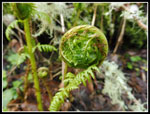 Fern Unfurls |
 Chuckanut Ridge Trail |
 Big Boulders |
 Trail On Ridge |
 Northern Peaks |
 More Northern Peaks |
 Ridge Top |
 Mt. Baker |
 Baker & Twin Sisters |
 More New Signs |
 Scramble Spot |
 Ridge Top Rocks |
 Pond On Ridge |
 Steep Downhill |
 Chuckanut Mt. Summit |
 Cyrus Gates Overlook |
 Overlook View |
 Another View |
 Steep Stairs |
 The Rock Trail |
 Mossy Cliffs |
 Fluted Rock |
 Mossy Boulders |
 Shadows |
 Pock Marks |
 A Face? |
 Holy Rock? |
 More Stairs |
 Lost Lake Signs |
 Lost Lake |
 Another Skunk Cabbage |
 Slick Muck |
 North Lost Lake Trail |
 Split Waterfalls |
 More Sandstone |
 Big Fungus |
 Trillium |
 Mushrooms |
 Falls Again |
 Interurban Trail Door |
 Bleeding Hears Close Up |
Trips - 2017
Home