4-14-17
Good
Friday is a holiday in my business. Nearly every year, rain or shine, I
get out for a hike without the weekend crowds. This year looked more
like rain than shine. I waited for the bulk of the morning road
gridlock to ease before heading out. At 9:00 am radar showed
it was snowing over East Tiger Mountain and raining lower down. Still
it was only showers and I might get lucky and have a half way dry day.
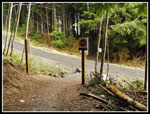
Traffic was not too bad and I arrived at the 1350' trailhead at Tiger
Summit off Highway 15 at 9:45 am. It was not raining. I had pieced
together a partial loop that used several biker trails that I had not
hiked yet. New trails are always good. There was only three cars by the
highway and half a dozen more at the inner lot. Not bad.
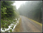
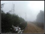
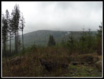
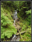
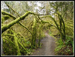
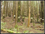
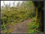
I took the connector trail over to the main road. Many years, bike trails are closed during the winter and reopened on 4-15. I was one day early. There were no signs at the Northwest Timber Trail. Either it opened early or was never closed this winter. I quickly headed uphill on the Master Link Trail. This is a one way uphill bike trail. Hikers are allowed in both directions. Though the grade is very gentle, making the trail longer, it is a nice option versus the road walk to East Tiger. The trail is marked as 2.5 miles though it seems longer. It does hike fast as there are no steep sections. Before long I was in the haze. It made for some interesting photos as clouds were visible in the forest. Not close to pea soup fog but it was pretty gray.
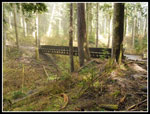
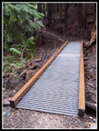
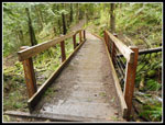
After switchbacking all over the forest I reached the big steel I-beam bridge. One of the largest trees I see on Tiger Mountain is right at the start of the bridge. In wet areas I saw yellow skunk cabbage. That continued all along the route. There was even one in the creek below the bridge. I hoped to see more spring flowers like trillium, yellow violets, and bleeding hearts but had no luck on the way up. I saw one woman running on the Northwest Timber Trail just as I was leaving it. I saw nobody at all on the Master Link. I finally reached the upper road at 11:09 am. I had covered 2.9 miles in 1:14. Not great speed but not too bad with a dozen photo stops. The road continues on to the summit but I chose to had back into the forest on the Quick Link Trail. This is a longer more gently graded route. Again, bikes go uphill and hikers can go both directions. More switchbacks and I again came out on the road. A little more uphill brought me to the start of the Predator Trail. This used to be an unofficial hikers trail over Sally's Summit and down. Now it is one black diamond, steep as heck bike trail. We hiked down it before it was open to bikes. No hikers are allowed on it.
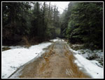
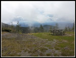
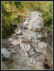
A little downhill brought me to a junction. Right goes up the last .70 miles to the top of East Tiger Mountain. There was some snow along the road higher up. Most snow is now gone. A group of three bikers then a solo biker passed me on the road. As I climbed up the clouds became thicker. Not much visibility near the summit. I arrived to find all four bikers at the picnic tables. It was 11:43 am when I reached the 3004' summit. 1:48 to hike 4 miles with 1650' of gain. I ascended with a light long sleeve shirt. It was 36 degrees on top with a cold wind. Time for a jacket. I had an early lunch and the others soon headed down. Views did not open up. No Mt. Rainier view this day.
After 10 minutes on top I was ready to leave. At that time it began to snow. Over three weeks into spring and 25 miles east of Puget Sound it was snowing. Then it turned to hail. A little bit of everything this day. By the time I had lost 200' of elevation a sucker hole allowed bright sunlight to shine through. One minute lost in a gray cloud and then squinting into the bright sun. That did not last long. I considered hiking down the Off The Grid Trail that parallels the road but chose the road instead. The trail takes a much less direct route as it has some long switchbacks to lose elevation. I hoped to get back early enough to avoid the worst of the afternoon traffic in Seattle. The road route would save close to half an hour. I did take the short long cut going down the Quick Link Trail.
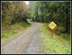
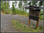
I have hiked up to East Rattlesnake on this road all the way from Highway 18 in 2010. A long 13+ mile road walk. Back then the trails I would hike today were not yet built except for the Northwest Timber Trail. The new trails make this loop possible in a reasonable distance. From the road at the Quick Link - Master Link junction it is about a mile to where the Off The Grid Trail crosses the road and continues downhill as the Fully Rigid Trail. All I had to do was not miss that spot. That was not a problem. First is a sign for drivers alerting to a trail crossing of the road. Next was the trails sign board with trails names and mileages. Then there were the two picnic tables. Not easy to miss the trails junction. I headed downhill on the Fully Rigid Trail. While the Master Link and Quick Link are signed for any ability, the Fully Rigid warns of difficult spots. It has some mud, some sharp turns, and one jump that goes right between two close together trees. I'd be walking my bike there.
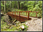
The trail was easy hiking. There was one old trail blocked with small branches. A look down it showed a good sized cut log. That is something to explore at a later date. The Fully Rigid Trail becomes the Joy Ride Trail. At one point the Swamp Trail come in. This is a newer and much differently placed version of the old Silent Swamp hikers Trail. I hiked it on my 2010 trip right before it was all clear cut. There are an amazing array of bridges on the Fully Rigid/Joy Ride/Northwest Timber Trail route. Steel I-beam based ones and older style all wood bridges. Even the wood bridges have different styles. I saw at least four styles of bridges in the roughly 3.5 miles on these trails. On the way down my umbrella went up and down many times. Short squalls were followed by breaks in the weather. Other than up high the wind was minimal.
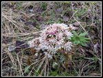
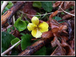
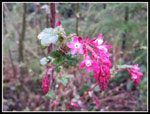
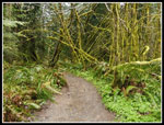
As I dropped down I began to see the spring flowers absent from the rest of the route. First were trillium. I saw quite a few of them. Next were yellow violets. Some big clumps of them. I did see bleeding heart plants but no flowers yet. There were some other flowering shrubs too. I saw a lone runner and a biker along here. The route crossed one more small spur road and reached the Northwest Timber Trail. The map showed it to be pretty flat. That is not entirely true. There were a number of ups and downs. Not a lot but it did add a few hundred feet of elevation gain.. The trail goes through some great mossy sections and also a good sized clear cut. I could see the bottom of Rattlesnake Mountain but the top was in clouds. This 2.2 mile section really seemed to go on and on. The rain picked up more when I reached the clear cut. Out with the umbrella once again. Towards the end of the trail two more bikes zoomed by. Right before the end of the Northwest Timber Trail I met a family with three kids out for a damp day in the forest.
Once back at the road I crossed over to the connector trail and in just a few minutes reached the parking lot. Quite a few more cars than in the morning. It was 2:15 p when I reached my car. A total of 5:19 minutes to hike 10 miles with about 1900' of elevation gain. 3.5 miles of the trip were on three trails I had not hiked before. That's a rarity on Tiger Mountain. Other than a half mile slowdown on the I-90 floating bridge I had an easy drive home. Out after morning traffic and back before afternoon gridlock.
This was a fun day. Having a holiday that few other have allows for some solitude on trails close to Seattle. The weather probably kept others at home. It was a near perfect day for an umbrella hike. I did not get very wet as the rain came in then went out numerous times. I had sunshine (a little), snow, and hail. The misty clouds and overcast brought out some great colors. No glare to blow out photos. All in all, a great weekday to not be at work and to be in the mountains instead.
Click on thumbnails to get
larger pictures.
Trips - 2017
Home
I took the connector trail over to the main road. Many years, bike trails are closed during the winter and reopened on 4-15. I was one day early. There were no signs at the Northwest Timber Trail. Either it opened early or was never closed this winter. I quickly headed uphill on the Master Link Trail. This is a one way uphill bike trail. Hikers are allowed in both directions. Though the grade is very gentle, making the trail longer, it is a nice option versus the road walk to East Tiger. The trail is marked as 2.5 miles though it seems longer. It does hike fast as there are no steep sections. Before long I was in the haze. It made for some interesting photos as clouds were visible in the forest. Not close to pea soup fog but it was pretty gray.
After switchbacking all over the forest I reached the big steel I-beam bridge. One of the largest trees I see on Tiger Mountain is right at the start of the bridge. In wet areas I saw yellow skunk cabbage. That continued all along the route. There was even one in the creek below the bridge. I hoped to see more spring flowers like trillium, yellow violets, and bleeding hearts but had no luck on the way up. I saw one woman running on the Northwest Timber Trail just as I was leaving it. I saw nobody at all on the Master Link. I finally reached the upper road at 11:09 am. I had covered 2.9 miles in 1:14. Not great speed but not too bad with a dozen photo stops. The road continues on to the summit but I chose to had back into the forest on the Quick Link Trail. This is a longer more gently graded route. Again, bikes go uphill and hikers can go both directions. More switchbacks and I again came out on the road. A little more uphill brought me to the start of the Predator Trail. This used to be an unofficial hikers trail over Sally's Summit and down. Now it is one black diamond, steep as heck bike trail. We hiked down it before it was open to bikes. No hikers are allowed on it.
A little downhill brought me to a junction. Right goes up the last .70 miles to the top of East Tiger Mountain. There was some snow along the road higher up. Most snow is now gone. A group of three bikers then a solo biker passed me on the road. As I climbed up the clouds became thicker. Not much visibility near the summit. I arrived to find all four bikers at the picnic tables. It was 11:43 am when I reached the 3004' summit. 1:48 to hike 4 miles with 1650' of gain. I ascended with a light long sleeve shirt. It was 36 degrees on top with a cold wind. Time for a jacket. I had an early lunch and the others soon headed down. Views did not open up. No Mt. Rainier view this day.
After 10 minutes on top I was ready to leave. At that time it began to snow. Over three weeks into spring and 25 miles east of Puget Sound it was snowing. Then it turned to hail. A little bit of everything this day. By the time I had lost 200' of elevation a sucker hole allowed bright sunlight to shine through. One minute lost in a gray cloud and then squinting into the bright sun. That did not last long. I considered hiking down the Off The Grid Trail that parallels the road but chose the road instead. The trail takes a much less direct route as it has some long switchbacks to lose elevation. I hoped to get back early enough to avoid the worst of the afternoon traffic in Seattle. The road route would save close to half an hour. I did take the short long cut going down the Quick Link Trail.
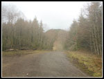
I have hiked up to East Rattlesnake on this road all the way from Highway 18 in 2010. A long 13+ mile road walk. Back then the trails I would hike today were not yet built except for the Northwest Timber Trail. The new trails make this loop possible in a reasonable distance. From the road at the Quick Link - Master Link junction it is about a mile to where the Off The Grid Trail crosses the road and continues downhill as the Fully Rigid Trail. All I had to do was not miss that spot. That was not a problem. First is a sign for drivers alerting to a trail crossing of the road. Next was the trails sign board with trails names and mileages. Then there were the two picnic tables. Not easy to miss the trails junction. I headed downhill on the Fully Rigid Trail. While the Master Link and Quick Link are signed for any ability, the Fully Rigid warns of difficult spots. It has some mud, some sharp turns, and one jump that goes right between two close together trees. I'd be walking my bike there.
The trail was easy hiking. There was one old trail blocked with small branches. A look down it showed a good sized cut log. That is something to explore at a later date. The Fully Rigid Trail becomes the Joy Ride Trail. At one point the Swamp Trail come in. This is a newer and much differently placed version of the old Silent Swamp hikers Trail. I hiked it on my 2010 trip right before it was all clear cut. There are an amazing array of bridges on the Fully Rigid/Joy Ride/Northwest Timber Trail route. Steel I-beam based ones and older style all wood bridges. Even the wood bridges have different styles. I saw at least four styles of bridges in the roughly 3.5 miles on these trails. On the way down my umbrella went up and down many times. Short squalls were followed by breaks in the weather. Other than up high the wind was minimal.
As I dropped down I began to see the spring flowers absent from the rest of the route. First were trillium. I saw quite a few of them. Next were yellow violets. Some big clumps of them. I did see bleeding heart plants but no flowers yet. There were some other flowering shrubs too. I saw a lone runner and a biker along here. The route crossed one more small spur road and reached the Northwest Timber Trail. The map showed it to be pretty flat. That is not entirely true. There were a number of ups and downs. Not a lot but it did add a few hundred feet of elevation gain.. The trail goes through some great mossy sections and also a good sized clear cut. I could see the bottom of Rattlesnake Mountain but the top was in clouds. This 2.2 mile section really seemed to go on and on. The rain picked up more when I reached the clear cut. Out with the umbrella once again. Towards the end of the trail two more bikes zoomed by. Right before the end of the Northwest Timber Trail I met a family with three kids out for a damp day in the forest.
Once back at the road I crossed over to the connector trail and in just a few minutes reached the parking lot. Quite a few more cars than in the morning. It was 2:15 p when I reached my car. A total of 5:19 minutes to hike 10 miles with about 1900' of elevation gain. 3.5 miles of the trip were on three trails I had not hiked before. That's a rarity on Tiger Mountain. Other than a half mile slowdown on the I-90 floating bridge I had an easy drive home. Out after morning traffic and back before afternoon gridlock.
This was a fun day. Having a holiday that few other have allows for some solitude on trails close to Seattle. The weather probably kept others at home. It was a near perfect day for an umbrella hike. I did not get very wet as the rain came in then went out numerous times. I had sunshine (a little), snow, and hail. The misty clouds and overcast brought out some great colors. No glare to blow out photos. All in all, a great weekday to not be at work and to be in the mountains instead.
 On My Way |
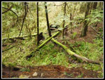 Many Shades Of Green |
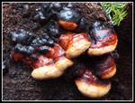 Colorful Fungus |
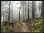 Misty Trail |
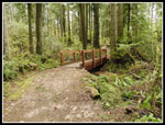
 Largest Bridge |
 Big Mossy Rock |
 Skunk Cabbage |
 New Bridge |
 Top Of Master Link |
 Snow Along Road |
 East Tiger In Sight |
 Coltsfoot |
 Nearing Summit |
 Fresh Snow |
 Viewpoint? |
 Junction Ahead |
 Roadside Rest Area |
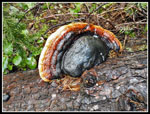 More Fungus |
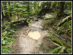 Mud Puddles |
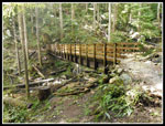 Steel I-Beam Bridge |
 Draping Moss |
 Colorful Moss |
 Trillium |
 Salmonberry |
 Cloudy Rattlesnake Mt. |
 Yellow Violet |
 Colorful Flowers |
 Wooden Bridge |
 Cascading Creek |
 Cable Side Rails |
 Rock Trail |
 Back To Mossy Trees |
 Arch Over Trail |
 Striped Trees |
 Last Mossy Trees |
Trips - 2017
Home