1-02-17
January
2nd and time to get out on
the first hike of the new year. Sub freezing temperatures, some snow in
the lowlands around Seattle, and sunny skies. I chose a close in hike
with a bit of a view. After hiking on Friday and Saturday to end 2016 I
took off Sunday New Year's Day. Monday was the holiday and I had to get
in a first hike of the new year. The lowlands had an bit of snow and
sub freezing temperatures the past few days and I was not excited to
drive icy roads before getting my new tired put on. That meant another
trip to the Issaquah Alps. I had not been up the Poo Poo Point Trail to
the Point in sometime. 8 miles with 2000' of elevation gain sounded
good. It was very cold with a clear sky. There are few spots on Cougar,
Squak, and Tiger with any viewpoints now that the trees have engulfed
the summits. Poo Poo Point does have views. That settled it.
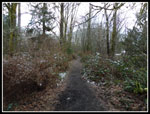
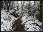
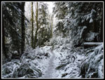
I was slow to get going in the morning. Not out of the house until about 8:30 am. A little more time to warm up the day. I arrived at the High School Trailhead in Issaquah at about 9:00 am. All the spots in the small lot were taken but there were several spots along the road. The temperature was in the high 20s when I started out. Not cold for much of the country in the winter but cold for the Seattle area. I headed up the old RR Grade then onto the High School Trail. Before I reached the power line corridor some of the trees were flocked with fresh snow. There was none on the trail. Two folks passed be under the power lines and turned up the Section Line Trail. I went right to the Poo Poo Point Trail. This old road/trail gains elevation at a steady grade.
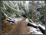
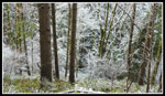
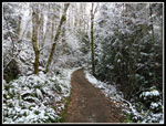
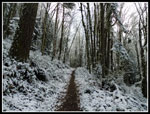
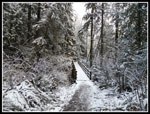
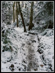
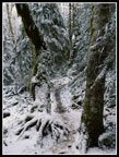
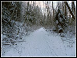
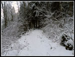
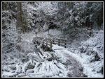
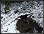
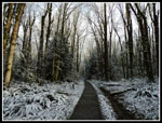
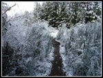
Just as I started up the trail I passed two guys who had stopped. I passed three more groups in the next mile. Within that mile the hard crunchy ground began to be partly covered with hard icy snow. Well packed down icy snow.There was enough dirt to allow me to proceed with just boots. The trees and brush were all snow covered. This is about as pretty as the old road/trail ever looks. I booted it up to the big bridge in Many Creek Valley and beyond. The trail was now getting very slick but the section after the bridge is quite flat. That changes dramatically when the old road is left and steep trail begins. This next section is probably the steepest on the route to the West Side RR Grade.
I stopped at this point and put on micro spikes. The slipping instantly ended and I had better traction on the steep spots than on dry dirt. The spike dug securely into the icy snow. I passes several groups going up and down. Those without traction devices were having a hard time. I would have fallen at least a couple times when coming down. I made reasonably good time going up. A couple were catching up with me and I sped up quite a bit nearing the grade. I just beat them up. They were heading up the One View Trail and I turned off right on the grade heading for Poo Poo Point. A little down then up followed by the steeper down from the grade down to the old road below. The road heads gently uphill to the parking lot at Poo Poo Point.
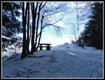
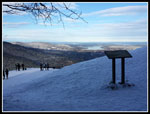
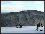
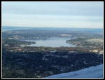
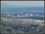
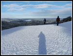
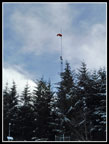
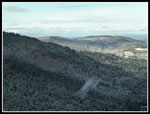
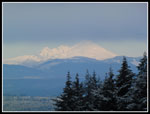
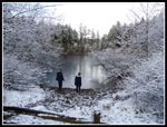
I arrived at the Point at 10:40 am. I took 1:34 minutes to hike up four miles. Not bad with the snow. The entire hike up was dead calm. It was not so at Poo Poo Point. My thermometer read 20 degrees and with a steady cold wind it felt very cold. Down on the para sailor take off strip there was a little sunshine. I headed down. It was still very cold but it felt better in the sun. Good views out to Bellevue, Squak and Cougar Mountains, The Olympics, and even Mt. Baker. The ground was covered in snow and so was much of the ground down below. This is one hike where you can see where you started. Issaquah High School is easy to pick out. I took a number of photos and a panorama video. I planned to take a few photos and head down. I actually spent almost half an hour on top. My fingers were almost numb with taking off gloves to shoot photos. They headed back up when I started moving. Down the old road and then up the steep climb to the RR Grade. I looked forward to the climb as the effort warmed by back up.
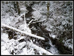
Back at the Poo Poo Point, One View, RR Grade junction I headed down. I soon began passing some of the folks I passed on the way up. Their ascents were pretty slow. Not too surprising with the icy trail. I made good time going down. One guy ran by me with no traction devices on. I would have fallen numerous times in just boots at the speed he was going. It was still early when I reached the power line corridor. I could retrace my route up and be done in one more mile. Or I could take advantage of the mostly flat plateau and get in a few more miles. I chose the latter. I hiked along the Gas Line Trail to the Bus Trail and headed east towards the High Point Trailhead. I went all the way to the main Tradition Lake Trail that heads up Tiger 3. I went left then left again on the Around The Lake Trail. This brought me back to the Bus Trail. This detour added about two miles.
Back at the power line corridor I took the very short side trail to Round Lake. This "lake" is more of a marsh all summer. Now it had filled up again. It was frozen over. On the hike up the High School Trail I have passed the end of the Adventure Trail dozens of times over the decades. Since it does not go up to any of the peaks I had never hiked it. I knew the trail at Round Lake heads over to the north end of it. There is a map on a board at the lake. I took a look and taking that trail would add about another mile. I was well past time I had an Adventure. Off I went on the Wetlands Trail. The second junction was unsigned but I recalled from the map that I need to take another left turn. This took me downhill to another junction with the Adventure Trail.
I though it would be pretty flat but I was wrong. With ups and downs it added another 240' of gain to my day. Up and down and all around it went. One final descent brought me back to the High School Trail. Every year I try to hike at least ten new trails. I had one on my first hike of the new year. Now it was less than a mile down to the car. I finished up at 1:32 pm. I added 3 miles and 300' feet of elevation gain to the normal hike. 11 miles with 2300' of gain and I was back home by 2:10 pm. Not bad at all. This was a good leg stretcher with an easy drive. 20 degrees and wind was cold on top but with no wind the rest of the hike was war enough. I seldom write trip reports on Tiger Mountain but with the fresh snow it takes on a beauty seldom seen. All in all, it was an excellent first hike of the new year.
Click on thumbnails to get
larger pictures.
Trips - 2017
Home
I was slow to get going in the morning. Not out of the house until about 8:30 am. A little more time to warm up the day. I arrived at the High School Trailhead in Issaquah at about 9:00 am. All the spots in the small lot were taken but there were several spots along the road. The temperature was in the high 20s when I started out. Not cold for much of the country in the winter but cold for the Seattle area. I headed up the old RR Grade then onto the High School Trail. Before I reached the power line corridor some of the trees were flocked with fresh snow. There was none on the trail. Two folks passed be under the power lines and turned up the Section Line Trail. I went right to the Poo Poo Point Trail. This old road/trail gains elevation at a steady grade.
Just as I started up the trail I passed two guys who had stopped. I passed three more groups in the next mile. Within that mile the hard crunchy ground began to be partly covered with hard icy snow. Well packed down icy snow.There was enough dirt to allow me to proceed with just boots. The trees and brush were all snow covered. This is about as pretty as the old road/trail ever looks. I booted it up to the big bridge in Many Creek Valley and beyond. The trail was now getting very slick but the section after the bridge is quite flat. That changes dramatically when the old road is left and steep trail begins. This next section is probably the steepest on the route to the West Side RR Grade.
I stopped at this point and put on micro spikes. The slipping instantly ended and I had better traction on the steep spots than on dry dirt. The spike dug securely into the icy snow. I passes several groups going up and down. Those without traction devices were having a hard time. I would have fallen at least a couple times when coming down. I made reasonably good time going up. A couple were catching up with me and I sped up quite a bit nearing the grade. I just beat them up. They were heading up the One View Trail and I turned off right on the grade heading for Poo Poo Point. A little down then up followed by the steeper down from the grade down to the old road below. The road heads gently uphill to the parking lot at Poo Poo Point.
I arrived at the Point at 10:40 am. I took 1:34 minutes to hike up four miles. Not bad with the snow. The entire hike up was dead calm. It was not so at Poo Poo Point. My thermometer read 20 degrees and with a steady cold wind it felt very cold. Down on the para sailor take off strip there was a little sunshine. I headed down. It was still very cold but it felt better in the sun. Good views out to Bellevue, Squak and Cougar Mountains, The Olympics, and even Mt. Baker. The ground was covered in snow and so was much of the ground down below. This is one hike where you can see where you started. Issaquah High School is easy to pick out. I took a number of photos and a panorama video. I planned to take a few photos and head down. I actually spent almost half an hour on top. My fingers were almost numb with taking off gloves to shoot photos. They headed back up when I started moving. Down the old road and then up the steep climb to the RR Grade. I looked forward to the climb as the effort warmed by back up.
Back at the Poo Poo Point, One View, RR Grade junction I headed down. I soon began passing some of the folks I passed on the way up. Their ascents were pretty slow. Not too surprising with the icy trail. I made good time going down. One guy ran by me with no traction devices on. I would have fallen numerous times in just boots at the speed he was going. It was still early when I reached the power line corridor. I could retrace my route up and be done in one more mile. Or I could take advantage of the mostly flat plateau and get in a few more miles. I chose the latter. I hiked along the Gas Line Trail to the Bus Trail and headed east towards the High Point Trailhead. I went all the way to the main Tradition Lake Trail that heads up Tiger 3. I went left then left again on the Around The Lake Trail. This brought me back to the Bus Trail. This detour added about two miles.
Back at the power line corridor I took the very short side trail to Round Lake. This "lake" is more of a marsh all summer. Now it had filled up again. It was frozen over. On the hike up the High School Trail I have passed the end of the Adventure Trail dozens of times over the decades. Since it does not go up to any of the peaks I had never hiked it. I knew the trail at Round Lake heads over to the north end of it. There is a map on a board at the lake. I took a look and taking that trail would add about another mile. I was well past time I had an Adventure. Off I went on the Wetlands Trail. The second junction was unsigned but I recalled from the map that I need to take another left turn. This took me downhill to another junction with the Adventure Trail.
I though it would be pretty flat but I was wrong. With ups and downs it added another 240' of gain to my day. Up and down and all around it went. One final descent brought me back to the High School Trail. Every year I try to hike at least ten new trails. I had one on my first hike of the new year. Now it was less than a mile down to the car. I finished up at 1:32 pm. I added 3 miles and 300' feet of elevation gain to the normal hike. 11 miles with 2300' of gain and I was back home by 2:10 pm. Not bad at all. This was a good leg stretcher with an easy drive. 20 degrees and wind was cold on top but with no wind the rest of the hike was war enough. I seldom write trip reports on Tiger Mountain but with the fresh snow it takes on a beauty seldom seen. All in all, it was an excellent first hike of the new year.
 Starting Out |
 A Little Snow |
 Icy Branches |
 Snowy Off Trail |
 Trail Junction |
 Ascending To More Snow |
 A Narrow Sliver |
 Nearing Bridge |
 Icy Trail |
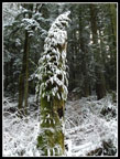
 Snowy Moss |
 Nearing Point |
 At Poo Poo Point |
 Several Groups |
 Sun & Squak Mountain |
 Lake Sammamish |
 Bellevue |
 Long Shadow |
 Wind Sock |
 Squak & Cougar |
 Mt. Baker |
 Heading Down |
 Back To Bridge |
 Snowy Creek |
 Smaller Bridge |
 Snowy Ferns |
 Lower Poo Poo Trail |
 Bus Trail |
 Snowy Scotch Broom |
 Round Lake |
 Adventure Trail |
Trips - 2017
Home