1-15-17
I
planned a trip to Wallace Falls and Lake back in early November.
Something kept getting in the way. The year came to an end and I still
had not done it. Well, this was the time. I made it to Monroe in good
time. Half way to Sultan traffic came to a stop. Stop and go most of
the way to Gold Bar. One ambulance did pass us heading east but I never
saw it again. Is ski traffic this bad on a Sunday morning? After a 1:15
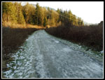
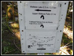
drive I arrived at the trailhead at 9:05 am. The first old
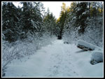
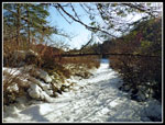
road section under the power lines had a lot of solid ice. I walked
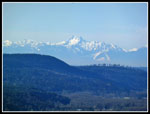
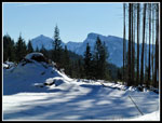
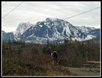
along the far edge to get by. Good views of Mt. Baring and Mt. Index
from the end of the road. I headed into the forest and immediately
reached the first junction. Right on the Woody Trail and the short way
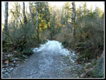
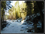
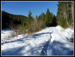
to the falls. I went left on the old railroad grade. Some more icy
spots along the grade. None long enough to put on microspikes. It was
23 degrees in Sultan and likely the mid 20s when I started out. This
would be the last day of the cold dry weather.
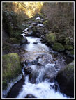
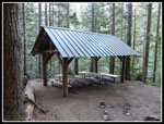
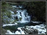
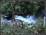
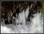
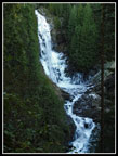
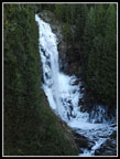
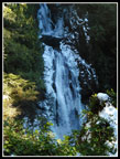
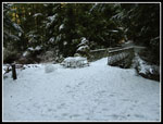
I sped along the grade to about the 2.3 mile point where I took a short trail down to the Wallace Falls Trail. A drop down to cross one fork of the Wallace River then steeply up to the covered picnic spot. I took a break here to photograph the lower falls. Running water but lots of ice too. The middle falls was in sight and looked even more icy. One of the best parts of the cold spell is all the icy waterfalls. Soon I was heading up to the middle falls. It was in fact full of ice. The sun is so low now that though it was now 10:35 am there was no glare. The middle falls looked great. Views out to the valley below. All blue sky overhead. On to the upper falls.
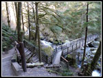
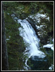
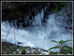
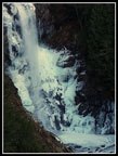
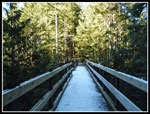
There were several groups at the upper falls when I arrived. More ice and rushing water. I took a few photos and continued on. The route up to the road above the falls is now mostly a built trail. Not all the obvious a the bottom but it get better higher up. When I reached the road I turned right and went over to the new bridge. At some point the new trails at Reiter will connect up to the Wallace Falls and Lake trails. Snow on the bridge and anywhere not in forest at this elevation. I went a little farther on the road system across the bridge but soon retraced my steps. I'll explore there later in the year.
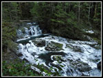
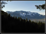
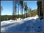
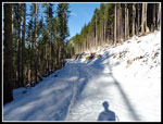
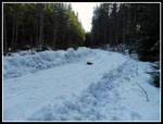
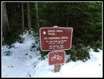
Now I had 2.4 miles of road to Wallace Lake. The first part in forest was dirt with a little snow. Once I popped out in the new clear cuts it was solid snow. On my last visit the tree cutting was underway and a few opening were appearing. Now there are some very good views down to and across the Skykomish Valley. There were also clear views of parts of the Olympic Mountains, much to my surprise. The snow was pretty well packed down. No need for snowshoes, microspikes, or even gaiters. The forest was still very cold abut sun shone on the clear cuts and it was much warmer. I'm not a big fan or clear cuts but the views and sunshine were nice on this day. Footing was pretty good but snow travel is slower. The road came out at junction. Right or left goes to the Greg Ball Trail route down. Right goes straight to Wallace Lake. I turned right. .60 miles from the junction to the lake. That went by faster. Once back in forest the snow was less and harder packed.
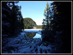
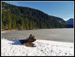
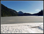
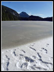
I reached the lake at 12:30 pm. 6.3 miles down and 5 miles back to the trailhead. Add another mile as I headed around the lake. The snow can be deeper and soft on the route around the lake. The lake is now popular enough that a packed trail went all the way. Year ago, I would go to the lake in winter and not see any other footprints. Those days are long gone. The snow was not very deep and pretty well consolidated. The lake was in the sunshine. My route was all in cold shade. At the end of the lake the inlet stream was all under snow. An easy walk to Pebble Beach. Well, no pebbles are showing with the snow cover. The inlet was completely in sunshine. It felt much warmer. I did not want to leave. First was lunch time and photos.
I arrived at 12:45 pm. I stayed a full half hour. Two folks left just as I arrived. Another guy came and went while I lounged in the sunshine. The lake was fully frozen over. I could not break the ice by the shore. I had no intention in walking out on it. At 1:15 pm I headed back. As I walked out the inlet route I heard a couple guys heading on towards Jay Lake. Heading back into the shade dropped the temperature by about 30 degrees. At least it felt like it. Back around the lake to the outlet and time to head down. .60 miles brought me to the main road. The road had been plowed. Not down to the gravel but the snow was thin and hard. Easy walked back to the Greg Ball Trail.
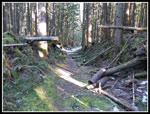
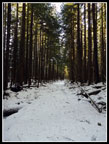
The first half of the Ball Trail was under snow. Lots of branches had recently fallen. I moved about 30 of them off the trail while coming down.The snow was easy to walk on. As it thinned it became very slick. Several times I nearly fell. Time to put on microspikes. Problem solved. Before long the snow was gone and so were the spikes. The bare trail hiked much faster. Before long I was back at the end of the railroad grade. After not seeing many folks after the upper falls I immediately ran into a number of groups.
The last 2.3 mils went by very quickly. I took the longer railroad grade route heading down too. Some of the ice on the last power line section had melted. The rain this coming week will take care of the rest of it. The lot was a little more than half full when I arrived at 3:25 pm. Highway 2 traffic was slow as always on a Sunday and it took me about 1:30 to drive home. Half an hour just from Gold Bar to Sultan. Not nearly as bad as on some days.
It took me a long time to fit this trip in but it was well worth it. :The falls are great after heavy rain then they are raging. They are also great when they are icy and snowy. The blue sky and ice was fantastic today. It as a great trip. The snow may have kept folks from doing the full loop as I had solitude from the falls to the lake. I hiked about 12 miles on the day with 1800' of elevation gain.
Click on thumbnails to get
larger pictures.
Trips - 2017
Home
I sped along the grade to about the 2.3 mile point where I took a short trail down to the Wallace Falls Trail. A drop down to cross one fork of the Wallace River then steeply up to the covered picnic spot. I took a break here to photograph the lower falls. Running water but lots of ice too. The middle falls was in sight and looked even more icy. One of the best parts of the cold spell is all the icy waterfalls. Soon I was heading up to the middle falls. It was in fact full of ice. The sun is so low now that though it was now 10:35 am there was no glare. The middle falls looked great. Views out to the valley below. All blue sky overhead. On to the upper falls.
There were several groups at the upper falls when I arrived. More ice and rushing water. I took a few photos and continued on. The route up to the road above the falls is now mostly a built trail. Not all the obvious a the bottom but it get better higher up. When I reached the road I turned right and went over to the new bridge. At some point the new trails at Reiter will connect up to the Wallace Falls and Lake trails. Snow on the bridge and anywhere not in forest at this elevation. I went a little farther on the road system across the bridge but soon retraced my steps. I'll explore there later in the year.
Now I had 2.4 miles of road to Wallace Lake. The first part in forest was dirt with a little snow. Once I popped out in the new clear cuts it was solid snow. On my last visit the tree cutting was underway and a few opening were appearing. Now there are some very good views down to and across the Skykomish Valley. There were also clear views of parts of the Olympic Mountains, much to my surprise. The snow was pretty well packed down. No need for snowshoes, microspikes, or even gaiters. The forest was still very cold abut sun shone on the clear cuts and it was much warmer. I'm not a big fan or clear cuts but the views and sunshine were nice on this day. Footing was pretty good but snow travel is slower. The road came out at junction. Right or left goes to the Greg Ball Trail route down. Right goes straight to Wallace Lake. I turned right. .60 miles from the junction to the lake. That went by faster. Once back in forest the snow was less and harder packed.
I reached the lake at 12:30 pm. 6.3 miles down and 5 miles back to the trailhead. Add another mile as I headed around the lake. The snow can be deeper and soft on the route around the lake. The lake is now popular enough that a packed trail went all the way. Year ago, I would go to the lake in winter and not see any other footprints. Those days are long gone. The snow was not very deep and pretty well consolidated. The lake was in the sunshine. My route was all in cold shade. At the end of the lake the inlet stream was all under snow. An easy walk to Pebble Beach. Well, no pebbles are showing with the snow cover. The inlet was completely in sunshine. It felt much warmer. I did not want to leave. First was lunch time and photos.
I arrived at 12:45 pm. I stayed a full half hour. Two folks left just as I arrived. Another guy came and went while I lounged in the sunshine. The lake was fully frozen over. I could not break the ice by the shore. I had no intention in walking out on it. At 1:15 pm I headed back. As I walked out the inlet route I heard a couple guys heading on towards Jay Lake. Heading back into the shade dropped the temperature by about 30 degrees. At least it felt like it. Back around the lake to the outlet and time to head down. .60 miles brought me to the main road. The road had been plowed. Not down to the gravel but the snow was thin and hard. Easy walked back to the Greg Ball Trail.
The first half of the Ball Trail was under snow. Lots of branches had recently fallen. I moved about 30 of them off the trail while coming down.The snow was easy to walk on. As it thinned it became very slick. Several times I nearly fell. Time to put on microspikes. Problem solved. Before long the snow was gone and so were the spikes. The bare trail hiked much faster. Before long I was back at the end of the railroad grade. After not seeing many folks after the upper falls I immediately ran into a number of groups.
The last 2.3 mils went by very quickly. I took the longer railroad grade route heading down too. Some of the ice on the last power line section had melted. The rain this coming week will take care of the rest of it. The lot was a little more than half full when I arrived at 3:25 pm. Highway 2 traffic was slow as always on a Sunday and it took me about 1:30 to drive home. Half an hour just from Gold Bar to Sultan. Not nearly as bad as on some days.
It took me a long time to fit this trip in but it was well worth it. :The falls are great after heavy rain then they are raging. They are also great when they are icy and snowy. The blue sky and ice was fantastic today. It as a great trip. The snow may have kept folks from doing the full loop as I had solitude from the falls to the lake. I hiked about 12 miles on the day with 1800' of elevation gain.
 Icy Road/Trail |
 Some Ice On RR Grade |
 Old Trestle Site |
 Bridge Over River |
 Wallace River |
 Picnic Shelter |
 Icy Lower Falls |
 Icy Falls |
 Gorge |
 Icicles |
 Icy Gorge |
 Lower Falls Again |
 Middle Falls |
 Closer Look |
 Icy Middle Falls |
 Valley Overlook |
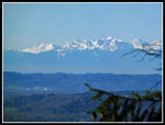 The Olympic Mts. |
 The Brothers |
 Upper Falls |
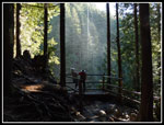 Viewpoint |
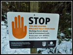 State Park Boundary |
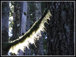 Glowing Moss |
 Road Across Bridge |
 Bridge Above Falls |
 Map & Sign |
 Road To Lake |
 Clear Cut |
 Compacted Snow |
 Mountain View |
 Along The Meadow |
 Nearing The Lake |
 Back Into State Park |
 Wallace Lake Outlet |
 Pebble Beach |
 Wallace Lake In Sunshine |
 Snowy Footprints |
 Inlet Creek |
 Inlet Picnic Table |
 Plowed Road |
 Greg Ball Trail |
 Mts. Persis & Baring |
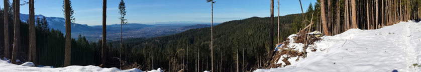 Panorama view from the new clear cut between Wallace Falls and Wallace Lake |
 Mt. Baring |
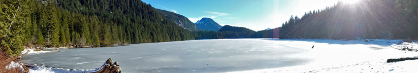 Panorama view of Wallace Lake taken from the inlet at Pebble Beach |
Trips - 2017
Home