4-29-17
Gary
and John were free for a weekend hike. Rain was coming in during the
afternoon. We chose to head east for a spring wildflower hike of the
Westberg Trail on Manastash Ridge. My first visit was with Janet on
4-05-14. This trip was 24 days later. This has been a cold spring but I
hoped that the wildflower show would be farther along. In fact it was
about the same. We met in Bellevue at 7:00 am and headed east. Contrary
to the forecast of partly cloudy and becoming almost completely cloudy
we had blue sky through the mountains and down to the east side. We
continuted past Cle Elum and exited in Thorp at exit 101. A right turn
and two miles later another right turn on signed Cove Road. The end of
the road is the trail parking lot. In 2014 we found the lot already
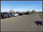
more than half full in the morning. This time it was nearly entirely
full at our 8:20 am arrival. By 8:30 am we were packed and on the way.
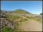
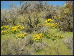
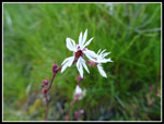
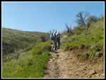
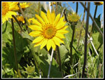
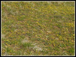
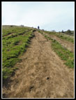
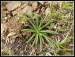
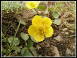
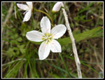
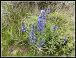
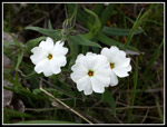
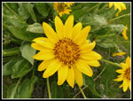
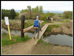
There is now a sign board at the start though it has no relevant information. A bridge crosses a canal and starts up the canyon. There is another route that immediately climbs steeply up the nose of the ridge to the right. That was our descent route. This early there is plenty of water at the bottom and the possibility of rattlesnakes. We did see a non rattler on the way down. Wildflowers began immediately. Some balsamroot, ballhead waterleaf, and woodland star were at the base of the canyon. As we climbed higher more wildflowers appeared. This day we did not have a huge variety of flowers but large amounts of those in bloom. Glacier lilies were done but later flowers like lupine and paintbrush are still to come. On the way down we did come upon several small lupine plants that have just begun to bloom. High up there wre thousands of bitterroot plants. There will be a terrific bitterroot display in three or four weeks.
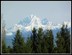
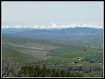
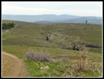
As we climbed the views behind up opened up. Down to the farms and ranches and out to the snow covered mountains. Most prominent is Mt. Stuart and the Stuart Range. They are still completely covered in winter white. The locals hike this trail early in the morning. They were soon passing us on their way down. Locals were easy to differentiate from those of us who had long drives. They did not have backpacks and cameras. Just out for a little morning exercise. They also did not have a two hour drive.
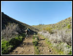
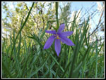
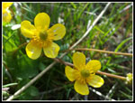
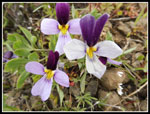
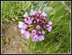
We saw other flowers like tiny penstemon, varieties of small yellow flowers I could not identify, violet grass widows, and bluebells. Spring beauty appeared and never went away. We saw it along much of our route. Some varieties were quite large. Yellow bells appeared next and buttercups. Sagebrush violets were another that once seen were all along the route. The trail has no switchbacks. None as in zero. It is straight up the canyon until it meets the other trail on the ridge top then straight up the ridge. We measured 1670' of gain in two miles to the upper ridge top memorial site. There are some flatter spots then more steep climbs. It was 32 degrees at Snoqualmie Pass but in the 50s as we climbed. With the sun it was pleasantly warm. Warm enough to cause sweat. After a long dark cold winter and early spring it was nice to be out in the sunshine.
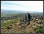
As the trail nears the upper ridge top it turns right and continues to climb to the memorial site. There were a few big trees along the trail but for the most part it is completely in the open. We could see the top from the parking lot and most of the way up the trail. Some Kittitas County Search and Rescue folks were visible from a mile away. They had bright orange hats (with KCSR on them). We passed them coming down as we neared the memorial site. We arrived at the memorial to find it empty. A little solitude. Great views on this clear day. From the Cascade peaks to Mt. Stuart to Ellensburg far below. We took a food and water break here. We arrived at almost 10:00 am. With all the flower photo stops we took nearly 1:30 to hike up two miles. And we have no regrets about all the stops. Great views and very good wildflower display.
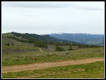
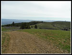
The vast majority of folks who hike up to the memorial site turn around and head back down. A few hikers continue on. Most all of them had backpacks and cameras. If you get up early and drive two hours you usually want more than a four mile round trip hike. We were not half way to our turn around point. Surprisingly, we also had gained barely half of the day's elevation gain. The ridge top is wide and does not have much forest. There are some trees along the north side but the rest is grass and wildflowers with some roads. The trip out and back to the memorial would be entirely on rocky dirt roads. The ridge is rolling hills. Three miles out to the UW observatory and back gained and lost almost 1500'. Lots of uphill in both directions.
A short walk from the memorial brought us to the main road. A right turn heads downhill. This is where we began to see the bitterroot plants. First a few, then dozens, then hundreds. More of the same wildflowers we had seen on the way up. On the ridge top the balsamroot have barely begun to bloom. Lots of sagebrush violets, grass widows, yellow bells, spring beauty, and more. Soon after reaching the road we stepped off to let a four wheel ATV pass by. Then another. Then some more. Then even more. I did not keep count but within three to five minutes we must have seen 25 go by. Some big club was having a big outing. After they went by we saw one single truck on the hike out and all the way back to the memorial site. No motorcycles and no mountain bikes either. One big whoosh of ATVs and then hours of solitude. Not a bad trade off.
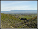
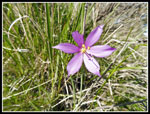
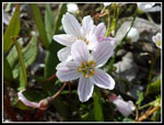
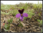
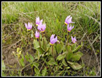
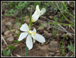
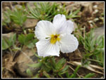
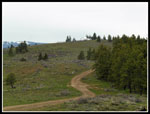
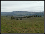
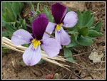
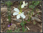
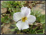
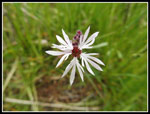
The road drops to a junction with three options. We chose the left one. It worked. There was a big puddle in the road at the low point. John noticed shooting stars in bloom here. That was an unexpected treat. There were not very many of them but they were right at their peak. The road was smooth at times and very rocky at others. Much rockier than I recalled. It required care in foot placement to not slip and fall or twist an ankle. Not that hard to hike on but tiresome. From the top of the ridge views opened to the south. Down to the valley of Umtanum Creek and over to Umtanum Ridge. We climbed to a high point then dropped down then climbed back up a number of times. On one decent I noticed a white flower that was too big to be spring beauty. I went over to take a look and found it to be a white grass widow. In years of spring hikes to east of the Cascade Crest I have seen many violet grass widows but this was the first white one. Walking back to the road I spotted another white flower. That one was a white violet. Another first time sighting within 20 feet of the first. Those two unusual wildflower sightings made my day.
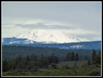
At the next high point we could see the observatory building in the distance. Down we went then up again then down then up. Here we found a little snow on the north side of the ridge that has survived to the end of April. I was beginning to wonder just where the observatory was. we kept walking and could not see it again. At long last it came into view. On the last descent we noticed another white flower. It was another white grass widow. No sitings in many years then two in half an hour. We climbed up to the observatory for our lunch break. The bottom of Mt. Rainier was in site. As we hike along the ridge high clouds had been moving in. Now the sun was gone for the day. The Stuart Range was still in the clear though later it too was in the clouds.
We stopped and found the bugs that were a minor bother at the memorial site were now a major bother. We had to look for a spot in the cold wind to lessen the problem. The were not biting or stinging but they swarmed us like in mid summer. I put on a jacket to keep them at bay and the cold wind kept it on later. After lunch we headed back and kept on jackets and put on gloves. Our warm sunny morning was now a dark cloudy day. The head wind we had on the way back added to the chill. We saw one hiker at a distance when we arrived at the observatory. We met several more hiking groups on the way back. We reached the observatory at 11:50 am. 3:20 to hike 5.3 miles. On the way back our photo stops were far fewer and we made much better time.
By 1:30 we were back at the memorial site. The bugs were awful. Our stay was short. The drop down the trail was steep but the footing was much better than on the road. We met some folks coming up but it was not crowded. We chose not to drop back into the canyon on our ascent route but stayed on the ridge top. The last descent off the nose of the ridge was very steep but short. We were back at the car by 2:50 pm. We anticipated a quick drive back to Seattle. That was not to be the case. On the drive in Gary noticed steam from paving on the westbound lanes of I-90 at the top of the Easton Hill. That led to a long backup on the way back as three lanes on the hill merged down to one lane at the top. It added nearly two hours to our drive home.
Even that did not mar a very nice trip. This was my second time on the trail and the first for Gary and John. Wildflowers were not at peak but put on a great display. The morning sunshine was much appreciated for the warmth and the views. Six of the 10+ miles we hiked provided a great degree of solitude. All in all, a great day on the trail. for the day we hiked 10.6 miles with 3100' of elevation gain.
Click on thumbnails to get
larger pictures.
Trips - 2017
Home
There is now a sign board at the start though it has no relevant information. A bridge crosses a canal and starts up the canyon. There is another route that immediately climbs steeply up the nose of the ridge to the right. That was our descent route. This early there is plenty of water at the bottom and the possibility of rattlesnakes. We did see a non rattler on the way down. Wildflowers began immediately. Some balsamroot, ballhead waterleaf, and woodland star were at the base of the canyon. As we climbed higher more wildflowers appeared. This day we did not have a huge variety of flowers but large amounts of those in bloom. Glacier lilies were done but later flowers like lupine and paintbrush are still to come. On the way down we did come upon several small lupine plants that have just begun to bloom. High up there wre thousands of bitterroot plants. There will be a terrific bitterroot display in three or four weeks.
As we climbed the views behind up opened up. Down to the farms and ranches and out to the snow covered mountains. Most prominent is Mt. Stuart and the Stuart Range. They are still completely covered in winter white. The locals hike this trail early in the morning. They were soon passing us on their way down. Locals were easy to differentiate from those of us who had long drives. They did not have backpacks and cameras. Just out for a little morning exercise. They also did not have a two hour drive.
We saw other flowers like tiny penstemon, varieties of small yellow flowers I could not identify, violet grass widows, and bluebells. Spring beauty appeared and never went away. We saw it along much of our route. Some varieties were quite large. Yellow bells appeared next and buttercups. Sagebrush violets were another that once seen were all along the route. The trail has no switchbacks. None as in zero. It is straight up the canyon until it meets the other trail on the ridge top then straight up the ridge. We measured 1670' of gain in two miles to the upper ridge top memorial site. There are some flatter spots then more steep climbs. It was 32 degrees at Snoqualmie Pass but in the 50s as we climbed. With the sun it was pleasantly warm. Warm enough to cause sweat. After a long dark cold winter and early spring it was nice to be out in the sunshine.
As the trail nears the upper ridge top it turns right and continues to climb to the memorial site. There were a few big trees along the trail but for the most part it is completely in the open. We could see the top from the parking lot and most of the way up the trail. Some Kittitas County Search and Rescue folks were visible from a mile away. They had bright orange hats (with KCSR on them). We passed them coming down as we neared the memorial site. We arrived at the memorial to find it empty. A little solitude. Great views on this clear day. From the Cascade peaks to Mt. Stuart to Ellensburg far below. We took a food and water break here. We arrived at almost 10:00 am. With all the flower photo stops we took nearly 1:30 to hike up two miles. And we have no regrets about all the stops. Great views and very good wildflower display.
The vast majority of folks who hike up to the memorial site turn around and head back down. A few hikers continue on. Most all of them had backpacks and cameras. If you get up early and drive two hours you usually want more than a four mile round trip hike. We were not half way to our turn around point. Surprisingly, we also had gained barely half of the day's elevation gain. The ridge top is wide and does not have much forest. There are some trees along the north side but the rest is grass and wildflowers with some roads. The trip out and back to the memorial would be entirely on rocky dirt roads. The ridge is rolling hills. Three miles out to the UW observatory and back gained and lost almost 1500'. Lots of uphill in both directions.
A short walk from the memorial brought us to the main road. A right turn heads downhill. This is where we began to see the bitterroot plants. First a few, then dozens, then hundreds. More of the same wildflowers we had seen on the way up. On the ridge top the balsamroot have barely begun to bloom. Lots of sagebrush violets, grass widows, yellow bells, spring beauty, and more. Soon after reaching the road we stepped off to let a four wheel ATV pass by. Then another. Then some more. Then even more. I did not keep count but within three to five minutes we must have seen 25 go by. Some big club was having a big outing. After they went by we saw one single truck on the hike out and all the way back to the memorial site. No motorcycles and no mountain bikes either. One big whoosh of ATVs and then hours of solitude. Not a bad trade off.
The road drops to a junction with three options. We chose the left one. It worked. There was a big puddle in the road at the low point. John noticed shooting stars in bloom here. That was an unexpected treat. There were not very many of them but they were right at their peak. The road was smooth at times and very rocky at others. Much rockier than I recalled. It required care in foot placement to not slip and fall or twist an ankle. Not that hard to hike on but tiresome. From the top of the ridge views opened to the south. Down to the valley of Umtanum Creek and over to Umtanum Ridge. We climbed to a high point then dropped down then climbed back up a number of times. On one decent I noticed a white flower that was too big to be spring beauty. I went over to take a look and found it to be a white grass widow. In years of spring hikes to east of the Cascade Crest I have seen many violet grass widows but this was the first white one. Walking back to the road I spotted another white flower. That one was a white violet. Another first time sighting within 20 feet of the first. Those two unusual wildflower sightings made my day.
At the next high point we could see the observatory building in the distance. Down we went then up again then down then up. Here we found a little snow on the north side of the ridge that has survived to the end of April. I was beginning to wonder just where the observatory was. we kept walking and could not see it again. At long last it came into view. On the last descent we noticed another white flower. It was another white grass widow. No sitings in many years then two in half an hour. We climbed up to the observatory for our lunch break. The bottom of Mt. Rainier was in site. As we hike along the ridge high clouds had been moving in. Now the sun was gone for the day. The Stuart Range was still in the clear though later it too was in the clouds.
We stopped and found the bugs that were a minor bother at the memorial site were now a major bother. We had to look for a spot in the cold wind to lessen the problem. The were not biting or stinging but they swarmed us like in mid summer. I put on a jacket to keep them at bay and the cold wind kept it on later. After lunch we headed back and kept on jackets and put on gloves. Our warm sunny morning was now a dark cloudy day. The head wind we had on the way back added to the chill. We saw one hiker at a distance when we arrived at the observatory. We met several more hiking groups on the way back. We reached the observatory at 11:50 am. 3:20 to hike 5.3 miles. On the way back our photo stops were far fewer and we made much better time.
By 1:30 we were back at the memorial site. The bugs were awful. Our stay was short. The drop down the trail was steep but the footing was much better than on the road. We met some folks coming up but it was not crowded. We chose not to drop back into the canyon on our ascent route but stayed on the ridge top. The last descent off the nose of the ridge was very steep but short. We were back at the car by 2:50 pm. We anticipated a quick drive back to Seattle. That was not to be the case. On the drive in Gary noticed steam from paving on the westbound lanes of I-90 at the top of the Easton Hill. That led to a long backup on the way back as three lanes on the hill merged down to one lane at the top. It added nearly two hours to our drive home.
Even that did not mar a very nice trip. This was my second time on the trail and the first for Gary and John. Wildflowers were not at peak but put on a great display. The morning sunshine was much appreciated for the warmth and the views. Six of the 10+ miles we hiked provided a great degree of solitude. All in all, a great day on the trail. for the day we hiked 10.6 miles with 3100' of elevation gain.
 Parking Lot |
 Onto The Trail |
 Old Road To Start |
 Balsamroot Blooming |
 Mt. Stuart |
 Lone Balsamroot |
 Woodland Star |
 Ballhead Waterleaf |
 View Out |
 Gary & John |
 Bright Yellow |
 Shaded Grass Widow |
 Bright Grass Widow |
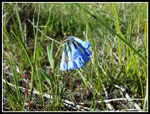 Bluebells |
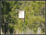 Bluebird & Birdhouse |
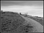 Black & White |
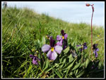 Sagebrush Violet |
 Field Of Yellow |
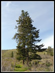 Big Trees |
 Buttercups |
 Spring Beauty |
 Steep Uphill |
 Farms & Peaks |
 At Memorial Site |
 Road To Observatory |
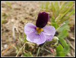 Lone Sagebrush Violet |
 Darker Violet |
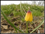 Yellow Bell |
 Bitterroot |
 A Buttercup |
 Shooting Stars |
 Another Uphill |
 White Grass Widow |
 White Violet |
 Looking Back |
 Observatory In Sight |
 Mt. Rainier |
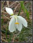 White Grass Widow #2 |
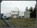 UW Observatory |
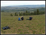 Lunch Time |
 Umtanum Ridge |
 More Violets |
 Lone Tree |
 White Widows Again |
 White Violet Again |
 Violet Grass Widow |
 Black Shell Flower |
 Violet & White |
 Female Bluebird |
 Dagger Pod |
 More Spring Beauty |
 Lupine |
 Perfect Woodland Star |
 Phlox |
 Big Balsamroot Flower |
 Off The Trail |
Trips - 2017
Home