1-14-18
Gary
and John were free for a
Sunday hike. The mountains had lots of snow during the week. We chose
to do a lower elevation hike that would be snow free. With talk of
clear cutting Blanchard Hill I wanted to get in another hike there
while the trees still stand. To top it off, a wet week turned into one
unseasonably warm and sunny Sunday. We headed north and met in Lynnwood
at 7:45 am. From there we continued north through Mt. Vernon up to the
Alger exit from I-5, just south of Bellingham. Onto Barrell Springs
Road and then the gravel road up to the upper trailhead for Blanchard
Hill. There were several cars in the lot when we arrived at 8:50 am. By
8:57 am we were on the trail. It was chilly but not freezing as we
started up the road/trail. For the first time the gate was open though
the sign does say it is closed to cars.
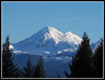
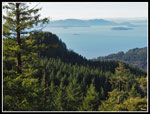
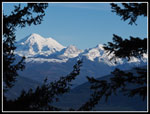
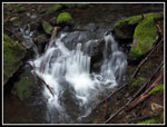
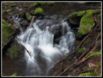
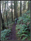
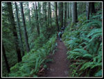
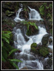
Doing the loop counterclockwise gets the road walking out of the way first. We hiked up the road to the quarry and found the spot across the road with views out to the valley below and Mt. Baker in the distance. Bright blue sky made for good contrast. All the creeks on the hillside beside the road were running higher than normal. There are a couple small but nice waterfalls. We reached the Alternate Incline Trail at the one mile point. Now we started climbing at a steeper grade than the road. The trail is steeper but not especially steep. Many stumps are remnants of the old forest. Higher up are metal reminders as well. Bits and pieces of cables and logging machinery. Right at the two mile mark we reached the junction with the Pacific Northwest Trail (PNT). That trail goes from Montana to the Pacific Ocean.
My plan was to follow the PNT then continue on to Oyster Dome. Then head back and pass by Lily Lake, go up North Butte, and drop to Lizard Lake. When we reached the PNT junction we met a couple mountain bikers who had just done a loop from Lizard Lake down to the road we started on then up several other roads and on a boot path back to the junction we were now at. Gary was interested in trying their loop. It would require added several miles of a route that was not on our maps. I could adjust our route to keep it close to the 10 miles planned. John was in and I agreed to trying this new route.
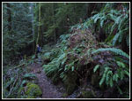
We headed into the forest and the path led to the end of a logging spur. We were able to navigate the roads even with a number of new spurs not on our maps. There were a number of junctions. We dropped about 600' to the road we had been hiking at the start of our trip. Fresh logging also provided a spot with views out to Mt. Baker. Once on the main road we started looking for a path heading into the woods. This should be the Lost Sailor Trail. Much sooner than expected we found a trail. It crossed the road and continued down. We expected this trail to lead up to the PNT at a point north of Lizard Lake. Our route quickly split. We took the left steeper trail and it quickly came to a complete end. Okay... Back down and off we went on the right trail. This would lead us up to the PNT. Except we came to another junction. They seemed about the same size. We took the left one that headed more uphill. Now we would be on the main trial to the PNT. Except we came to another junction. We again stayed left on the steeper track. It became even steeper and then very steep. The tread became less distinct but was still obvious.
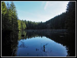
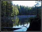
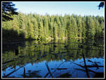
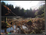
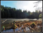
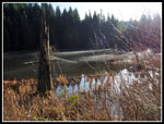
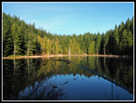
Up a steep gully and we found a "This is not a Trail" sign. I have never seen one of these out in the middle of nowhere. The trail petered out and we stopped to reconsider. The PNT was off to our right. We had been running parallel to it. for quite a while. We contoured right until we came to a big drop. We were atop a nice wide ridge. We chose to not drop down. We bushwhacked up through minimal brush. We came to a saddle where we met a trail cutting through. It lead down to the right and very quickly we reached Lizard Lake right by the outlet. We took a bread to look down the lake. Our route up from the road was a little less than one mile. It seemed longer. Now all we had to do was cross the outlet creek and there was the PNT. We headed around the lake and picked up the trail to North Butte and Lily Lake. This used to be a hard to find boot path but now it is a well signed trail.
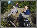
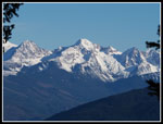
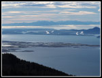
We soon reached the next junction and headed up to the top of North Butte. We saw folks heading up and down. The days of total solitude on North Butte ended with all the new trails and trail signs. Up at the summit we were finally in sunshine. It was warm. Very warm for mid January. No jacket needed. Not long sleeves either. We were not alone on top but there were only one or two others while we had lunch. We arrived at 12:00 pm. We stayed for 20 minutes. The sun was great. Views out are not as good as at Oyster Dome but not too bad. We dropped by the viewpoint east for a look at Mt. Baker and the Twin Sisters. There is just a window between trees. It seems to be closing a bit as the trees grow.
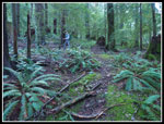
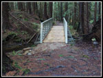
We headed down to Lily Lake. There was a tent in the campsites. A pretty nice weekend to camp at the lake. There was still a layer of low fog right on the water that looked pretty neat. The shore was also in bright sunshine. We slowly worked our way down to the outlet area. We did stop there for some more photos. It was almost 1:00 pm when we left the lake. A short trail took us to the main trail heading for Oyster Dome. I wore heavier boots as heavy recent rain had creek high and lots of mud on most trails. These trails have had recent trail work done and I saw much less mud than even a few years ago. Our trail followed the Lily Lake outlet creek and then crossed over it. This is at a place where the creek is wide enough to require several rock hops at high water. Except there is no rock crossing anymore. Now there is a big steel bridge across.
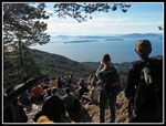
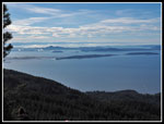
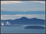
Soon we reached the junction with the Oyster Dome Trail coming up from Chuckanut Drive. It was easy to see the meeting point as we went from solitude to a conga line. Groups and groups and groups were ahead of us now. One more creek crossing without a bridge and it was uphill to the top. We arrived to find the largest crowds I have seen at Oyster Dome. Dozens of folks were sitting at the upper viewpoint. We took some photos and moved on. I always head over to the nearby real summit. There were two folks on the rocky forested top. No solitude to be found. We headed back to the viewpoints and stopped at the lower one. Great views out to salt water and the Olympic Mountains. Best of all we were back in sunshine. We sat down. we were not in a hurry to go back into the forest. With no wind and a temperature in the mid or upper 50s it felt like spring in January.
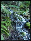
We spent about 50 minutes at Oyster Dome. At 1:18 pm we started down. Back in the conga line. Folks ahead of us. More right on our heels. Lock step until we reached the junction. The hoards turned right and we went back to solitude. We climbed back up to the Lily Lake junction and then went straight ahead. We left the old railroad grade at the Lily Lake Trail junction. Now we had 3 more miles of downhill back to the trailhead. The trail is gently graded and easy walking. The creeks were running fast but many were bridged and the others easy rock hops. The last traverse has the road in sight below and seems to go on forever. The last bridge had lots of water cascading down from above in a short falls. We saw very few folks on this trail. We made it down to the short road walk and reached the car at 3:55 pm. We had more than an hour of daylight left.
This turned out to be a fun hike. We had no snow, less mud than expected, and quite a bit of solitude. Oyster Dome was even more crowded than expected. The sunshine was a nice surprise and it was really warm for January. The unexpected loop was a lot of fun. We took a few wrong turns but it all worked out fine. I had a chance to see a new part of Blanchard Hill. I'll be back in snowshoes or on skis soon but it was a nice lowland trip and not on Tiger Mountain.
Click on thumbnails to get
larger pictures.
Trips - 2018
Home
Doing the loop counterclockwise gets the road walking out of the way first. We hiked up the road to the quarry and found the spot across the road with views out to the valley below and Mt. Baker in the distance. Bright blue sky made for good contrast. All the creeks on the hillside beside the road were running higher than normal. There are a couple small but nice waterfalls. We reached the Alternate Incline Trail at the one mile point. Now we started climbing at a steeper grade than the road. The trail is steeper but not especially steep. Many stumps are remnants of the old forest. Higher up are metal reminders as well. Bits and pieces of cables and logging machinery. Right at the two mile mark we reached the junction with the Pacific Northwest Trail (PNT). That trail goes from Montana to the Pacific Ocean.
My plan was to follow the PNT then continue on to Oyster Dome. Then head back and pass by Lily Lake, go up North Butte, and drop to Lizard Lake. When we reached the PNT junction we met a couple mountain bikers who had just done a loop from Lizard Lake down to the road we started on then up several other roads and on a boot path back to the junction we were now at. Gary was interested in trying their loop. It would require added several miles of a route that was not on our maps. I could adjust our route to keep it close to the 10 miles planned. John was in and I agreed to trying this new route.
We headed into the forest and the path led to the end of a logging spur. We were able to navigate the roads even with a number of new spurs not on our maps. There were a number of junctions. We dropped about 600' to the road we had been hiking at the start of our trip. Fresh logging also provided a spot with views out to Mt. Baker. Once on the main road we started looking for a path heading into the woods. This should be the Lost Sailor Trail. Much sooner than expected we found a trail. It crossed the road and continued down. We expected this trail to lead up to the PNT at a point north of Lizard Lake. Our route quickly split. We took the left steeper trail and it quickly came to a complete end. Okay... Back down and off we went on the right trail. This would lead us up to the PNT. Except we came to another junction. They seemed about the same size. We took the left one that headed more uphill. Now we would be on the main trial to the PNT. Except we came to another junction. We again stayed left on the steeper track. It became even steeper and then very steep. The tread became less distinct but was still obvious.
Up a steep gully and we found a "This is not a Trail" sign. I have never seen one of these out in the middle of nowhere. The trail petered out and we stopped to reconsider. The PNT was off to our right. We had been running parallel to it. for quite a while. We contoured right until we came to a big drop. We were atop a nice wide ridge. We chose to not drop down. We bushwhacked up through minimal brush. We came to a saddle where we met a trail cutting through. It lead down to the right and very quickly we reached Lizard Lake right by the outlet. We took a bread to look down the lake. Our route up from the road was a little less than one mile. It seemed longer. Now all we had to do was cross the outlet creek and there was the PNT. We headed around the lake and picked up the trail to North Butte and Lily Lake. This used to be a hard to find boot path but now it is a well signed trail.
We soon reached the next junction and headed up to the top of North Butte. We saw folks heading up and down. The days of total solitude on North Butte ended with all the new trails and trail signs. Up at the summit we were finally in sunshine. It was warm. Very warm for mid January. No jacket needed. Not long sleeves either. We were not alone on top but there were only one or two others while we had lunch. We arrived at 12:00 pm. We stayed for 20 minutes. The sun was great. Views out are not as good as at Oyster Dome but not too bad. We dropped by the viewpoint east for a look at Mt. Baker and the Twin Sisters. There is just a window between trees. It seems to be closing a bit as the trees grow.
We headed down to Lily Lake. There was a tent in the campsites. A pretty nice weekend to camp at the lake. There was still a layer of low fog right on the water that looked pretty neat. The shore was also in bright sunshine. We slowly worked our way down to the outlet area. We did stop there for some more photos. It was almost 1:00 pm when we left the lake. A short trail took us to the main trail heading for Oyster Dome. I wore heavier boots as heavy recent rain had creek high and lots of mud on most trails. These trails have had recent trail work done and I saw much less mud than even a few years ago. Our trail followed the Lily Lake outlet creek and then crossed over it. This is at a place where the creek is wide enough to require several rock hops at high water. Except there is no rock crossing anymore. Now there is a big steel bridge across.
Soon we reached the junction with the Oyster Dome Trail coming up from Chuckanut Drive. It was easy to see the meeting point as we went from solitude to a conga line. Groups and groups and groups were ahead of us now. One more creek crossing without a bridge and it was uphill to the top. We arrived to find the largest crowds I have seen at Oyster Dome. Dozens of folks were sitting at the upper viewpoint. We took some photos and moved on. I always head over to the nearby real summit. There were two folks on the rocky forested top. No solitude to be found. We headed back to the viewpoints and stopped at the lower one. Great views out to salt water and the Olympic Mountains. Best of all we were back in sunshine. We sat down. we were not in a hurry to go back into the forest. With no wind and a temperature in the mid or upper 50s it felt like spring in January.
We spent about 50 minutes at Oyster Dome. At 1:18 pm we started down. Back in the conga line. Folks ahead of us. More right on our heels. Lock step until we reached the junction. The hoards turned right and we went back to solitude. We climbed back up to the Lily Lake junction and then went straight ahead. We left the old railroad grade at the Lily Lake Trail junction. Now we had 3 more miles of downhill back to the trailhead. The trail is gently graded and easy walking. The creeks were running fast but many were bridged and the others easy rock hops. The last traverse has the road in sight below and seems to go on forever. The last bridge had lots of water cascading down from above in a short falls. We saw very few folks on this trail. We made it down to the short road walk and reached the car at 3:55 pm. We had more than an hour of daylight left.
This turned out to be a fun hike. We had no snow, less mud than expected, and quite a bit of solitude. Oyster Dome was even more crowded than expected. The sunshine was a nice surprise and it was really warm for January. The unexpected loop was a lot of fun. We took a few wrong turns but it all worked out fine. I had a chance to see a new part of Blanchard Hill. I'll be back in snowshoes or on skis soon but it was a nice lowland trip and not on Tiger Mountain.
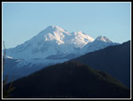 Mt. Baker View |
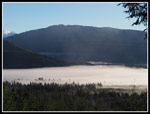 Fog In The Valley |
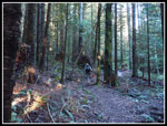 Alternate Incline Trail |
 Logging Remnants |
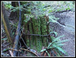
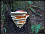 Fungus |
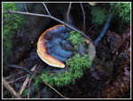 Colorful Fungus |
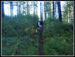 Off Trail Trail |
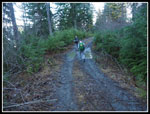 Muddy Road |
 Mt. Baker Again |
 Off Trail |
 Lizard Lake Reflection |
 Lizard Lake Outlet |
 Crisscrossed Logs |
 Waterfall |
 Dark Forest |
 North Butte Summit |
 North Butte View |
 Twin Sisters |
 Framed Mt. Baker |
 Lily Lake Glare |
 Fog On The Water |
 Lily Lake Shore |
 Lily Lake Reflection |
 New Bridge |
 Oyster Dome Crowd |
 Islands View |
 Mt. Erie |
 View Southwest |
 Cascade |
 Long Exposure |
 Lily Lake Trail |
 Sword Ferns Galore |
 Final Falls |
 Curvy Tree |
 Alien? |
 Tiny Mushrooms |
Trips - 2018
Home