Day 2
We
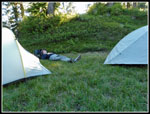
woke up to find our tents
covered in condensation. The brush around camp was all soaking wet. Our
route up Huckleberry Mountain would be largely up tall brush and
grass. On the plus side, the sky was finally clear with sun on our
campsite. We slept in and did not get up until past 8:00 am. I did not
need to walk far to fill my oatmeal bowl with fresh huckleberries. By
the time we were packed up to get hiking the brush was rapidly drying
out. The night before we did some exploring. The trail down to our
meadow in a basin kept going but soon ended. Our basin sat at the edge
of a big cliff. Thirty of so feet beyond John's tent the slope fell
away in a tall cliff. A gully ran from the far end of the meadow up
towards Huckleberry Mountain. We could see steep open grassy meadows
above. The middle of the meadow had forest below the upper grasses.
where we first reached the meadow another gully ran up towards the
summit. I went up that gully and found a trench that looked to be part
of the old trail. The grass, false hellebore, and small trees made it
tough to tell for sure. It did match the trail on my phone GPS app.
That is where we started out on Sunday morning.
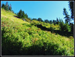
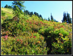
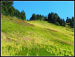
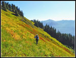
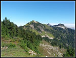
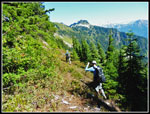
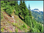
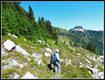
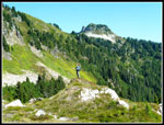
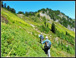
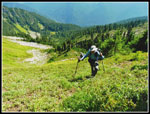
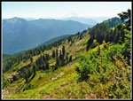
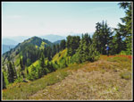
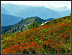
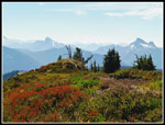
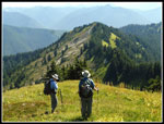
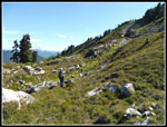
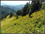
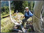
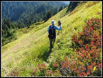
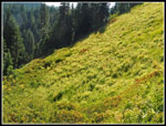
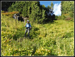
We left camp a few minutes before 10:00 am. We had all day to do a short distance. Short but not easy. The 26 years since Gary's previous trip had mostly obliterated the trail. He and his friend Mark had followed the trail up and camped at the summit. We were looking at more of a scramble up. The grass was mostly dry. We found that section of trail but lost it soon after. I led a bit and went up through a band of trees where the footing was better. We could barely see our feet in the tall hellebore and there were plenty of holes. We were ascending now a little right of the main gully. We came out of the trees to find... the trail. It was heading right and uphill. We soon lost it but kept going in the same direction. The slope was now less steep. We regained what seemed to be the trail just before a flat spot. The upper mountain was now laid out before us. It was all green grasses with yellowish false hellebore groves. We could see a number of spots that looked like a possible trail. We knew it rose to near the ridge top then followed it up and right to the summit of Huckleberry Mountain.
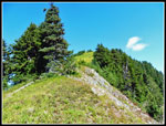
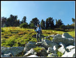
We scrambled up using the GPS map as a guide and did find the old trail. It was covered in grass but a little level tread was very much appreciated. It even had a couple switchbacks as it neared the ridge top. We reached the ridge right below several silvered snags that are very obvious. There was some wire there from the old lookout phone. I have found insulators before but seldom the actual phone wire. We kept ascending just right of the ridge top at the edge of grass. The ridge top has trees. Near the top the trail contours below the summit to the far side. The lookout site is never seen until you are right at it. A few more short switchbacks on the last climb. It is still not all that obvious as we had trouble staying on it up high when descending.
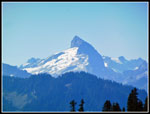
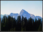
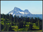
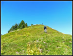
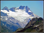
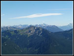
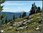
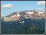
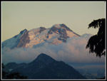
The route climbs the southwest ridge then cuts around the east side to reach a flat ridge top on the north. A short couple of steps up takes you to the lookout site. Gary camped on the flat grassy ridge top. The actual lookout site has grass and brush on all but the north side. Lots of melted glass but no wood. Multiple fire lookout sites say that the lookout was built in 1935 and burned by vandals in 1962. I have not been able to find even a single photo of the lookout building. The trip up was only .60 miles with 800' of elevation gain but it too us 1:24. Much time was spent trying to find the old trail. We had good views south from below the summit and great views most other directions from the lookout site. The sky was clear for views of Glacier Peak, Sloan Peak, Whitechuck, Pugh, Three Fingers, Whitehorse, Green, Buckindy, and more. It seemed hot though the thermometer only read 60 degrees.
On his previous trip Gary and Mark camped on the ridge by the lookout site then headed north to Boulder Peak, the next peak on the ridge. We had the same plan. What we lacked was good info. Gary keeps excellent records of his trips. We knew he found water in 1962. What we lacked was the best route to get to Boulder Peak. The ridge top descends gentle to a saddle between the peaks. The entire ridge is packed with trees. It is very narrow. Following the ridge top is not an option. The left side of the ridge is too steep. To the right is a boulder and grass basin about 300' lower. We chose to start along the ridge below the thick trees. It went okay at first but the slope became steeper and steeper. We found a spot where we could bail out down to the basin and took it. Now we had easier travel but could not see what the saddle ahead looked like.
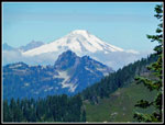
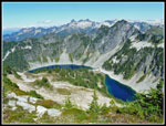
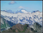
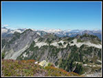
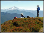
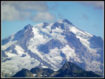
We dropped down farther and turned a corner to see the route up to the saddle. It was more steep grass, heather, and false hellebore. With big ripe huckleberries too. The slope steepened considerably near the top. Okay to ascend. It would be more interesting to come down. Once on top we started gently climbing to a flat meadow at the base of the final slopes up Boulder Peak. This was the best climbing of the day. No navigation needed. Just one steep step after another to the top. And oh what a top. Huckleberry Mountain is at an elevation of 5856'. Boulder Peak is at 6267'. The views are 360 degrees and spectacular. Below are Pear and Boulder Lakes. Behind the lakes is Hurricane Peak. To the north are Mt. Baker, Snowking, Buckindy, numerous other North Cascade summits. Heading east Dome Peak and Bonanza stand tall. Glacier Peak really stands out. We could even just make out the Olympic Mountains far to the west. A great spot to just take in the views. We arrived at 12:45 pm and stayed until 2:24 pm. We were the second party to sign the summit register this year.
Dropping off Boulder Peak was fast and easy. The drop from the saddle was much steeper but went just fine. Then we had the climb all the way up the rocky basin to just below the old Huckleberry lookout site summit. The basin was quite photogenic and made for easy travel. The last climb was steep but not too long. We arrived back at the lookout site at 3:35 pm. It was one mile between the summits. We took another break enjoying the views before heading down. We left the summit at 4:01 pm and arrived at camp at 4:48. It was much easier now that we knew the route. For the day we traveled a whole 3.3 miles with 1950' of elevation gain and loss. On trail that would not be hard. Off trail on steep slopes with lots of side hilling it was not that easy. The payoff was well worth the effort. After dinner and another round of Pass the Plate we headed to bed.
The forecast for Monday had clouds and a chance of rain. We were prepared to break camp in the rain and face lots of wet brush on the climb up to the real trail in the big meadow above. Instead we awoke in a cloud but with zero condensation on our tents. They were packed away almost entirely dry.
We left camp a few minutes before 10:00 am. We had all day to do a short distance. Short but not easy. The 26 years since Gary's previous trip had mostly obliterated the trail. He and his friend Mark had followed the trail up and camped at the summit. We were looking at more of a scramble up. The grass was mostly dry. We found that section of trail but lost it soon after. I led a bit and went up through a band of trees where the footing was better. We could barely see our feet in the tall hellebore and there were plenty of holes. We were ascending now a little right of the main gully. We came out of the trees to find... the trail. It was heading right and uphill. We soon lost it but kept going in the same direction. The slope was now less steep. We regained what seemed to be the trail just before a flat spot. The upper mountain was now laid out before us. It was all green grasses with yellowish false hellebore groves. We could see a number of spots that looked like a possible trail. We knew it rose to near the ridge top then followed it up and right to the summit of Huckleberry Mountain.
We scrambled up using the GPS map as a guide and did find the old trail. It was covered in grass but a little level tread was very much appreciated. It even had a couple switchbacks as it neared the ridge top. We reached the ridge right below several silvered snags that are very obvious. There was some wire there from the old lookout phone. I have found insulators before but seldom the actual phone wire. We kept ascending just right of the ridge top at the edge of grass. The ridge top has trees. Near the top the trail contours below the summit to the far side. The lookout site is never seen until you are right at it. A few more short switchbacks on the last climb. It is still not all that obvious as we had trouble staying on it up high when descending.
The route climbs the southwest ridge then cuts around the east side to reach a flat ridge top on the north. A short couple of steps up takes you to the lookout site. Gary camped on the flat grassy ridge top. The actual lookout site has grass and brush on all but the north side. Lots of melted glass but no wood. Multiple fire lookout sites say that the lookout was built in 1935 and burned by vandals in 1962. I have not been able to find even a single photo of the lookout building. The trip up was only .60 miles with 800' of elevation gain but it too us 1:24. Much time was spent trying to find the old trail. We had good views south from below the summit and great views most other directions from the lookout site. The sky was clear for views of Glacier Peak, Sloan Peak, Whitechuck, Pugh, Three Fingers, Whitehorse, Green, Buckindy, and more. It seemed hot though the thermometer only read 60 degrees.
On his previous trip Gary and Mark camped on the ridge by the lookout site then headed north to Boulder Peak, the next peak on the ridge. We had the same plan. What we lacked was good info. Gary keeps excellent records of his trips. We knew he found water in 1962. What we lacked was the best route to get to Boulder Peak. The ridge top descends gentle to a saddle between the peaks. The entire ridge is packed with trees. It is very narrow. Following the ridge top is not an option. The left side of the ridge is too steep. To the right is a boulder and grass basin about 300' lower. We chose to start along the ridge below the thick trees. It went okay at first but the slope became steeper and steeper. We found a spot where we could bail out down to the basin and took it. Now we had easier travel but could not see what the saddle ahead looked like.
We dropped down farther and turned a corner to see the route up to the saddle. It was more steep grass, heather, and false hellebore. With big ripe huckleberries too. The slope steepened considerably near the top. Okay to ascend. It would be more interesting to come down. Once on top we started gently climbing to a flat meadow at the base of the final slopes up Boulder Peak. This was the best climbing of the day. No navigation needed. Just one steep step after another to the top. And oh what a top. Huckleberry Mountain is at an elevation of 5856'. Boulder Peak is at 6267'. The views are 360 degrees and spectacular. Below are Pear and Boulder Lakes. Behind the lakes is Hurricane Peak. To the north are Mt. Baker, Snowking, Buckindy, numerous other North Cascade summits. Heading east Dome Peak and Bonanza stand tall. Glacier Peak really stands out. We could even just make out the Olympic Mountains far to the west. A great spot to just take in the views. We arrived at 12:45 pm and stayed until 2:24 pm. We were the second party to sign the summit register this year.
Dropping off Boulder Peak was fast and easy. The drop from the saddle was much steeper but went just fine. Then we had the climb all the way up the rocky basin to just below the old Huckleberry lookout site summit. The basin was quite photogenic and made for easy travel. The last climb was steep but not too long. We arrived back at the lookout site at 3:35 pm. It was one mile between the summits. We took another break enjoying the views before heading down. We left the summit at 4:01 pm and arrived at camp at 4:48. It was much easier now that we knew the route. For the day we traveled a whole 3.3 miles with 1950' of elevation gain and loss. On trail that would not be hard. Off trail on steep slopes with lots of side hilling it was not that easy. The payoff was well worth the effort. After dinner and another round of Pass the Plate we headed to bed.
The forecast for Monday had clouds and a chance of rain. We were prepared to break camp in the rain and face lots of wet brush on the climb up to the real trail in the big meadow above. Instead we awoke in a cloud but with zero condensation on our tents. They were packed away almost entirely dry.
 Heading For The Lookout |
 Sloan Peak |
 Good Colors On Ascent |
 Mt. Pugh |
 Huckleberry Mountain |
 Whitechuck Mountain |
 Traversing Slope |
 Mt. Baker |
 Boulder Peak Ahead |
 Heading To Boulder Pk |
 Getting Steeper |
 Dropped Into Basin |
 John On Knoll |
 Heading For Ridge |
 Nearing Ridge Top |
 On Ridge Top |
 Looking At Basin |
 Huckleberry Behind Us |
 Final Push To Boulder |
 Lakes Below Boulder |
 Fall Colors |
 Snowking Mountain |
 More Colors |
 Hurricane Peak |
 Dome Peak |
 John & Gary On Boulder |
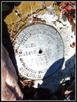 Boulder Benchmark |
 Green Mt. & Cloud |
 Descending Boulder Pk |
 On The Rocks |
 Partridge Foot |
 Basin & Glacier Peak |
 Lookout Is Above |
 Mt. Buckindy |
 Glacier Close Up |
 Descending Huckleberry |
 Phone Line |
 Trail & Color |
 Excellent Color |
 Final Grassy Gully |
 Time To Crash |
 Plate |
 Glacier Near Sunset |
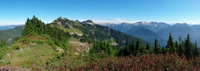 Panorama North From Huckleberry Lookout Site |
<< Day >>
Huckleberry Mountain Report
Home