3-18-18
Janet
planned a trip east of the
mountains and I signed on. Back on 3-10-12
Janet, Suzanne, Barry, and I did the Skyline Trail from the south end
to Gracie Point and slightly beyond. That was my first and only visit.
This would be my second. We were too early for many wildflowers in 2012
and I expected the same this time. The weather forecast was much better
there than much of the state. It was expected to be sunny and near 60
degrees. I was up for another sunny hike. it is a long drive
at
152 miles from my house. We met in Bellevue at 7:05 am and headed east.
It was very cloudy in the mountains but began to clear up at Easton and
kept getting better. We took the more scenic drive down the Yakima
Canyon Road to near Selah then on to the trailhead. Trailhead
directions are in the link above.
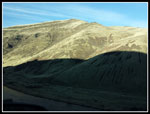
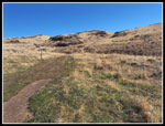
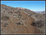
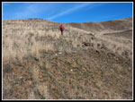
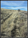
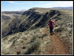
On the previous trip we drove by the gated road and on to to more eastern trailhead. This time we turned into the parking lot seen just after pavement ends on Buffalo Road. The gated road is about 1.5 miles to a shorter route to Gracie Point on the Skyline Trail. The road is very rough but Janet's Forerunner had no trouble with it. At the end of the trip there was a Forester and a Hummer at the trailhead. We followed the Forester out and they did okay. We arrived at the 1800' trailhead at about 9:34 am. Where the road starts to go down is the place to park and look for the trail. The route goes right up a drainage with no switchbacks. A straight shot to the ridge top. It is not particularly steep. By 9:49 am we were packed up and on the trail.
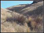
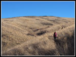
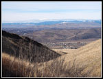
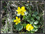
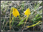
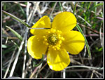
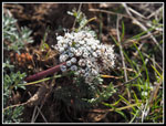
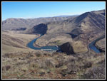
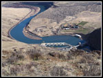
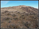
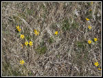
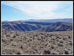
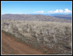
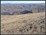
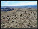
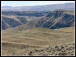
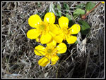
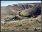
Fairly soon Janet noticed buttercups in bloom. We were hoping for a few wildflower sightings. One or two soon became a few dozen. Then the yellow bells appeared. There were a lot of those yellow flowers in bloom. We saw one or two other flowers but most were buttercups and yellow bells. Part way up we met a woman coming down already. The grasses are a bright brown all around. Very colorful. Behind us we could see the city. We reached the ridge top in 1.08 miles. That cut off almost two miles vs. the other trailhead we used in 2012. The other route also had several ups and downs along the ridge adding more elevation gain. What this route lacked was a longer time on the ridge top with great views out. From the ridge top we could see down to the Yakima River Canyon and Roza Dam. Great morning lighting on the canyon walls.
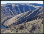
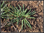
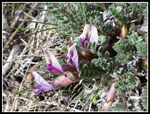
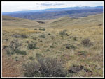
At the trail junction we found many bitterroot on the previous visit. A close look showed it to be the same this time. In another month or so there will be great bitterroot color up there. The route cuts around a bump on the ridge. The trail is narrow and the drop to the river seems to be vertical. Not a good place if one had vertigo. After that the ridge becomes much wider and the going is easy. The main trail drops down below the ridge and climbs back up again. We took it last time. On the way back we found a slightly longer route that follows a road and stays on the ridge top. A bit longer but much easier walking. We took that upper route this time. The route heads west then turns north after going below Gracie Point. The Skyline trail traverses around the right side of Gracie Point. One can easily go to the summit on a boot path and cross country. The real trail stays right of Gracie Point. The road goes to the left of it then cuts back to join the trail. We looked at the gently ridge heading up towards Gracie to the left and decided to take it.
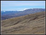
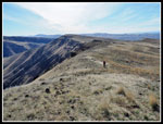
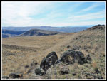
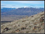
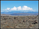
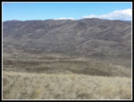
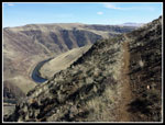
Our route was shorter and easier than the road/trail. We hit a road on the left ridge of Gracie Point and walked it to the 3200' summit. From the parking lot we could see Mt. Adams and as we climbed Mt. Rainier came into view. Now from the summit we added more mountain views to the west and north. Directly north of us was Umtanum Ridge. The Skyline Trail drops down from Gracie Point to Roze Creek then climbs up to the top of Umtanum Ridge. Most all of the trail was visible from Gracie Point. We reached the top at 11:36 am and had lunch. It was sunny but at times a cold breeze was blowing. It was not to bad on the summit. Our first visit took 4.75 miles to reach the top. This time we reached the summit in only 2.5 miles. It was much shorter than I was expecting.
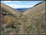
The trip was too short so we headed off to do a little exploring. First we headed down the north side. Part way down are ascending fence posts with a boot path alongside. This is the route we took from the Skyline Trail to the summit in 2012. Two hikers were coming up. We stopped to talk. They had backpacked from the south end to Roza Creek for the night. It was sub freezing and much colder than they expected. Still, they were having a great time. We continued dropping down the slope to where we turned around on my first visit. We intersected the Skyline Trail here. Some good views. We did not feel like dropping all the way down to the creek and climbing all the way back up. Instead we climbed back up the slope.
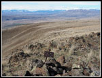
There area a lot of old roads all over the place. We followed one uphill and crossed several more along the way. The grade was steady until near the top when it headed right up the fall line. Very steep for a road at the top. Back on the ridge top we headed west, away from Gracie Point. The old ridge top road loses elevation very slowly. We dropped to pass a missing gate and stopped. Some great views all around from the ridge top. We headed off the road on the south side looking for any other wildflowers. There were a few but not many in bloom this early. What we did see was a whole lot of bitterroot. This place will be really colorful when they are n bloom. Not wanting to drop into the wrong drainage, we headed east until near where we came up the slope.
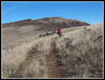
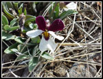
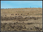
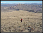
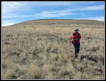
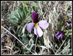
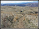
Heading down we saw a group of three on the road we took earlier. They were heading up to where it intersects the Skyline Trail. We continued down to the road after they had passed by. One woman with a dog, two backpackers, and a group of three at a distance. Not exactly a crowded hike so far. We followed the road south. Where it turns east we went cross country to a small bump. From there the views south were even better. Rather than retrace our steps we headed cross country in the general direction of the Skyline Trail. With zero trees up high and only a few sage bushes to avoid it's easy to head in any direction. Along here Janet managed to find a lot more flowers in bloom. Mostly more buttercups and yellow bells but also a few others. A single woodland star, some vetch, and more desert violets were a some seen. We crossed one ravine and ended up meeting the Skyline Trail not far from the junction with our trail down.
We saw two more folks at the junction. The trail down to the car is not that steep and made fore easy walking even though it goes straight down. That final mile did not take long. As mentioned there were two other cars at the trailhead. The Forester owners came down right after us. On the drive out we passed two groups of target shooters. They were not near the trailhead. Thank you.
This proved to be a great trip. The 300 miles round trip made for a long drive. The day of blue sky, near 60 degree warmth, and no snow made it all worthwhile. Though minimal still, the wildflower show was far better than I was expecting. Taking the scenic drive through the canyon instead of the freeway was nice too. It adds only 11 minutes according to Google Maps dependent on whether or not you have a slow driver ahead as there is only one lane each way. We had clouds in the mountains going home but not as thick as in the morning. All in all, it was a good day on the far eastern slopes.
Click on thumbnails to get
larger pictures.
Trips - 2018
Home
On the previous trip we drove by the gated road and on to to more eastern trailhead. This time we turned into the parking lot seen just after pavement ends on Buffalo Road. The gated road is about 1.5 miles to a shorter route to Gracie Point on the Skyline Trail. The road is very rough but Janet's Forerunner had no trouble with it. At the end of the trip there was a Forester and a Hummer at the trailhead. We followed the Forester out and they did okay. We arrived at the 1800' trailhead at about 9:34 am. Where the road starts to go down is the place to park and look for the trail. The route goes right up a drainage with no switchbacks. A straight shot to the ridge top. It is not particularly steep. By 9:49 am we were packed up and on the trail.
Fairly soon Janet noticed buttercups in bloom. We were hoping for a few wildflower sightings. One or two soon became a few dozen. Then the yellow bells appeared. There were a lot of those yellow flowers in bloom. We saw one or two other flowers but most were buttercups and yellow bells. Part way up we met a woman coming down already. The grasses are a bright brown all around. Very colorful. Behind us we could see the city. We reached the ridge top in 1.08 miles. That cut off almost two miles vs. the other trailhead we used in 2012. The other route also had several ups and downs along the ridge adding more elevation gain. What this route lacked was a longer time on the ridge top with great views out. From the ridge top we could see down to the Yakima River Canyon and Roza Dam. Great morning lighting on the canyon walls.
At the trail junction we found many bitterroot on the previous visit. A close look showed it to be the same this time. In another month or so there will be great bitterroot color up there. The route cuts around a bump on the ridge. The trail is narrow and the drop to the river seems to be vertical. Not a good place if one had vertigo. After that the ridge becomes much wider and the going is easy. The main trail drops down below the ridge and climbs back up again. We took it last time. On the way back we found a slightly longer route that follows a road and stays on the ridge top. A bit longer but much easier walking. We took that upper route this time. The route heads west then turns north after going below Gracie Point. The Skyline trail traverses around the right side of Gracie Point. One can easily go to the summit on a boot path and cross country. The real trail stays right of Gracie Point. The road goes to the left of it then cuts back to join the trail. We looked at the gently ridge heading up towards Gracie to the left and decided to take it.
Our route was shorter and easier than the road/trail. We hit a road on the left ridge of Gracie Point and walked it to the 3200' summit. From the parking lot we could see Mt. Adams and as we climbed Mt. Rainier came into view. Now from the summit we added more mountain views to the west and north. Directly north of us was Umtanum Ridge. The Skyline Trail drops down from Gracie Point to Roze Creek then climbs up to the top of Umtanum Ridge. Most all of the trail was visible from Gracie Point. We reached the top at 11:36 am and had lunch. It was sunny but at times a cold breeze was blowing. It was not to bad on the summit. Our first visit took 4.75 miles to reach the top. This time we reached the summit in only 2.5 miles. It was much shorter than I was expecting.
The trip was too short so we headed off to do a little exploring. First we headed down the north side. Part way down are ascending fence posts with a boot path alongside. This is the route we took from the Skyline Trail to the summit in 2012. Two hikers were coming up. We stopped to talk. They had backpacked from the south end to Roza Creek for the night. It was sub freezing and much colder than they expected. Still, they were having a great time. We continued dropping down the slope to where we turned around on my first visit. We intersected the Skyline Trail here. Some good views. We did not feel like dropping all the way down to the creek and climbing all the way back up. Instead we climbed back up the slope.
There area a lot of old roads all over the place. We followed one uphill and crossed several more along the way. The grade was steady until near the top when it headed right up the fall line. Very steep for a road at the top. Back on the ridge top we headed west, away from Gracie Point. The old ridge top road loses elevation very slowly. We dropped to pass a missing gate and stopped. Some great views all around from the ridge top. We headed off the road on the south side looking for any other wildflowers. There were a few but not many in bloom this early. What we did see was a whole lot of bitterroot. This place will be really colorful when they are n bloom. Not wanting to drop into the wrong drainage, we headed east until near where we came up the slope.
Heading down we saw a group of three on the road we took earlier. They were heading up to where it intersects the Skyline Trail. We continued down to the road after they had passed by. One woman with a dog, two backpackers, and a group of three at a distance. Not exactly a crowded hike so far. We followed the road south. Where it turns east we went cross country to a small bump. From there the views south were even better. Rather than retrace our steps we headed cross country in the general direction of the Skyline Trail. With zero trees up high and only a few sage bushes to avoid it's easy to head in any direction. Along here Janet managed to find a lot more flowers in bloom. Mostly more buttercups and yellow bells but also a few others. A single woodland star, some vetch, and more desert violets were a some seen. We crossed one ravine and ended up meeting the Skyline Trail not far from the junction with our trail down.
We saw two more folks at the junction. The trail down to the car is not that steep and made fore easy walking even though it goes straight down. That final mile did not take long. As mentioned there were two other cars at the trailhead. The Forester owners came down right after us. On the drive out we passed two groups of target shooters. They were not near the trailhead. Thank you.
This proved to be a great trip. The 300 miles round trip made for a long drive. The day of blue sky, near 60 degree warmth, and no snow made it all worthwhile. Though minimal still, the wildflower show was far better than I was expecting. Taking the scenic drive through the canyon instead of the freeway was nice too. It adds only 11 minutes according to Google Maps dependent on whether or not you have a slow driver ahead as there is only one lane each way. We had clouds in the mountains going home but not as thick as in the morning. All in all, it was a good day on the far eastern slopes.
 Skyline Ridge From Car |
 Looking Up From Start |
 Heading Up |
 Sea Of Brown |
 Looking Back |
 Buttercups |
 Yellow Bells |
 Close Up Buttercup |
 White Flower |
 Mt. Rainier |
 Nearing Ridge |
 Yakima River Canyon |
 Rose Dam |
 Canyon Walls |
 Bitterroot |
 Ascending Ridge |
 Gracie Point Is Ahead |
 Sagebrush Violet |
 Wide Ridge Top |
 Deer On The Run |
 More Buttercups |
 Looking Down Ridge |
 Off Road/Trail |
 Mt. Adams |
 Crater? |
 View Northwest |
 Gracie Point Summit |
 Puffy Clouds |
 Backpackers |
 Descending North |
 Umtanum Ridge |
 Heading Back |
 Steep Old Road |
 Wide Open Views |
 Colorful Canyon Walls |
 More Buttercups |
 Another Violet |
 Vetch |
 River View Again |
 Narrow Trail |
 Nearing Junction |
 Leaving Ridge Top |
 Narrow Gully |
 3 Cars In Lot |
Trips - 2018
Home