4-20-19
Saturday
looked to be a sunny day.
I had no idea where to go. My Discover Pass just ran out. That takes
care of a number of trailheads. I did not feel like a solo snowshoe
trip. I did not feel like a hike on a crowded I-90 trail. There are a
number of peaks west of the Cascades north of the Mountain Loop. I did
Anderson Mountain a year ago. I know of Frailey Mountain from my 45
year old Footsore Book. When evening searching brought up an Eric
Willhite report of visiting the
old lookout site I added it to my
sort list. My 11:00 pm I had settled on Frailey. At 7:08 am I was on my
way. Up to Highway 530 heading for Darrington. At the Oso Fire Station
I turned left on the Lake Cavanaugh Road. The gate is 5.1 miles from
the highway. I have passed that turnoff many times over the years. The
road starts paved then goes to gravel. It is steep and narrow in spots
but I had no trouble. There is room for 3 or 4 cars in front of the
gate and a couple more on the opposite side of the road.
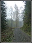
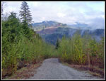
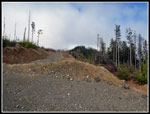
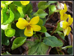
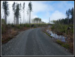
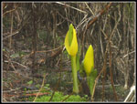
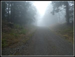
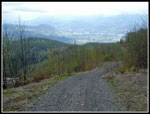
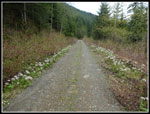
I doubt many people go up this route. It is a road. Roads are bad. Hikers don't hike roads. I do. Solitude and some great views. I've seen the photos if not the views. I was on my way from the 1150' gate at 8:27 am. The gate is only 61 miles from my home in North Seattle. It was a chilly 42 degrees at the start. I was a little disappointed in the lack of spring wildflowers. I did see a big display of coltsfoot lining the route. There was one spot with several skunk cabbage. Yellow violets made an appearance. Perhaps I was just a little early. The road starts out at a gentle grade. I used a gps receiver and a cell pone gps app. Neither map showed the first part of the road.
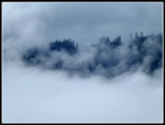
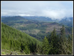
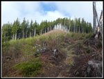
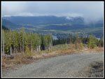
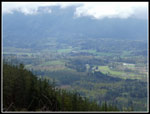
The route contoured around a bump and climbed to meet the ridge top. Now it follows the ridge all the way up. It goes from the left side to the right side of the ridge. Around the bump there is a ridge top clear cut providing some views out. As the road begins to climb more steeply I could see a bit of the NF Stillaguamish Valley. A view opened to the south and all I could see were thick dark clouds. A few trees stood out from the white on the south ridge of the valley. Overhead a big blue sucker hole opened leaving me in sunshine. Instantly it warmed up dramatically. As the road climbed I came to a junction. Left the road climbed a short way to the ridge top. That road looked to be more used. The road straight ahead was almost as large. I checked maps and straight ahead proved the correct route.
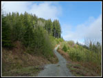
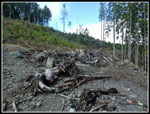
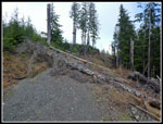
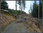
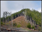
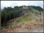
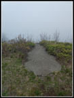
The road grade eased and a berm blocked forward progress. I went around and found a series of large logs across the road. I stepped over two and went under the rest. It was not hard to get by on foot. The road reached the ridge top in a clear cut. Probably some good views on a clear day. Another berm was easy to get around. The road dropped a little to the end. At first I did not see the trail up through the clear cut. Once found it makes the last climb easy enough. I could see the tower from the road end. There are trees near the tower and above the clear cut. I arrived on top at 9:57 am. I hiked 3.4 miles to the top in 1:30.
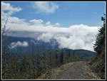
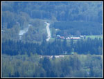
There was still some blue sky overhead. Most of the sky was still white. To the north I could see down to Cavanaugh Lake. To the south I could see white clouds up, down, and straight out. There is a rock with the grass worn off in a line of bare rock. It heads right over a cliff. This was where hang gliders took off in the 1970s and 1980s when folks could drive to the summit. Trip reports show that Whitehorse and Three Fingers are visible from here. I saw different shades of white. That is enough reason to come back. I hoped that it would be clearer when I came back later in the day. My next objective was to head west to the real summit of Frailey Mountain. The tower/lookout site is at an elevation of 2666'. There are two more western summits at 2721' and 2722'. I planned to head to the real summits.
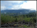
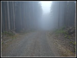
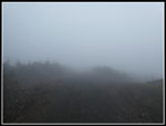
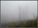
The road on the maps dropped down then contoured below the ridge top. I figured I could follow it until near the summits then bushwhack up to the top. I dropped down the road. At the bottom the road flattened and I saw some snow in the ditches along the road. That was the only snow seen all day. The road turned to the left side of the ridge and began to climb. This area looks to have been recently clear cut. There are still sections of forest and the clear cuts along the ridge. I reached a wet land and the sound of frogs was very loud. As I walked by they all stopped croaking. The clouds grew thicker on the ridge as I hiked to the west. Checking my GPS map it was clear that a new road is right below the ridge top and well above the one on the map. This made it easy to stay near the top of the ridge.
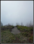
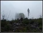
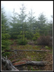
There are two more bumps along the ridge before reaching the real summit. These ups and downs and the real summit added almost 900' of gain round trip to the 1500' climb to the tower summit. In places the cloud was so thick that visibility dropped to 50'-60'. It made for a very moody feeling. I like hikes like that. After the second bump the road dropped then climbed up to near the top of Frailey Mountain I already knew the summit was in trees and provided no views. The two almost equal height summits are close together. I am not a summit bagger and did not find any need to tramp around looking for both. Just below the first summit there is a short spur switching back and climbing. It too is bermed. I went around that and when I was almost to the high point on the map I climbed up the cut bank about 20' to the top. The high point is a mossy opening with small trees all around. I stopped for a quick lunch. With the trees and clouds there was zero view. I reached the top at 10:51 am. It is right about 2 miles from the tower summit. If this spot was not the real summit it was awfully close. The ridge here is right about 2720'.
It was still early as I headed back. If anything the clouds grew even thicker on the return. It did not look like waiting would be very helpful. Up and down and up and down along the ridge I went with another visit to Frogville. I dropped to the low point and began the final climb several hundred feet up to the tower. Half way up I heard engines and then saw three motorcycles pass my by. Up at the tower I met them. They were close to my age. Bikers looking for a place to ride. I did not expect to see anyone on this hike. Three is not very crowded but was a bit unexpected. They had been up here two weeks earlier and were stopped by the amount of snow. Now it was virtually all gone. They headed off first as I finished my lunch. AI arrived on top at 11:45 am and left at 12:03 pm. The views were even worse than when I arrived in the morning.
The trip down was easier. I quickly dropped to the road below. Up a little then over and under the down logs and I was on open road to the bottom. At the road junction that goes over the ridge top to the south side I took that detour. Coming down the road views opened down to the NF Stilly Valley. I could not see any peaks but I could see the valley. I hoped that the road over the ridge would have some open views to the south. It did not. After dropping down I climbed back up and continued my descend on the main road. I reached the gate at 1:28 pm, almost exactly five hours after I started.
For the day I hiked just over 11 miles with 2400' of elevation gain. There were some wildflowers, some views, and several summits. I will need to return for the views out to snowy peaks. The trip did provide almost all the solitude I was expecting. Not many folks know about this route and very few would care to hike a logging road even if they did. That's fine with me. I will take solitude and views over forested trails and summits with a few hundred other hikers. Even without the views this proved to be a fun and successful trip.
Click on thumbnails to get
larger pictures.
Trips - 2019
Home
I doubt many people go up this route. It is a road. Roads are bad. Hikers don't hike roads. I do. Solitude and some great views. I've seen the photos if not the views. I was on my way from the 1150' gate at 8:27 am. The gate is only 61 miles from my home in North Seattle. It was a chilly 42 degrees at the start. I was a little disappointed in the lack of spring wildflowers. I did see a big display of coltsfoot lining the route. There was one spot with several skunk cabbage. Yellow violets made an appearance. Perhaps I was just a little early. The road starts out at a gentle grade. I used a gps receiver and a cell pone gps app. Neither map showed the first part of the road.
The route contoured around a bump and climbed to meet the ridge top. Now it follows the ridge all the way up. It goes from the left side to the right side of the ridge. Around the bump there is a ridge top clear cut providing some views out. As the road begins to climb more steeply I could see a bit of the NF Stillaguamish Valley. A view opened to the south and all I could see were thick dark clouds. A few trees stood out from the white on the south ridge of the valley. Overhead a big blue sucker hole opened leaving me in sunshine. Instantly it warmed up dramatically. As the road climbed I came to a junction. Left the road climbed a short way to the ridge top. That road looked to be more used. The road straight ahead was almost as large. I checked maps and straight ahead proved the correct route.
The road grade eased and a berm blocked forward progress. I went around and found a series of large logs across the road. I stepped over two and went under the rest. It was not hard to get by on foot. The road reached the ridge top in a clear cut. Probably some good views on a clear day. Another berm was easy to get around. The road dropped a little to the end. At first I did not see the trail up through the clear cut. Once found it makes the last climb easy enough. I could see the tower from the road end. There are trees near the tower and above the clear cut. I arrived on top at 9:57 am. I hiked 3.4 miles to the top in 1:30.
There was still some blue sky overhead. Most of the sky was still white. To the north I could see down to Cavanaugh Lake. To the south I could see white clouds up, down, and straight out. There is a rock with the grass worn off in a line of bare rock. It heads right over a cliff. This was where hang gliders took off in the 1970s and 1980s when folks could drive to the summit. Trip reports show that Whitehorse and Three Fingers are visible from here. I saw different shades of white. That is enough reason to come back. I hoped that it would be clearer when I came back later in the day. My next objective was to head west to the real summit of Frailey Mountain. The tower/lookout site is at an elevation of 2666'. There are two more western summits at 2721' and 2722'. I planned to head to the real summits.
The road on the maps dropped down then contoured below the ridge top. I figured I could follow it until near the summits then bushwhack up to the top. I dropped down the road. At the bottom the road flattened and I saw some snow in the ditches along the road. That was the only snow seen all day. The road turned to the left side of the ridge and began to climb. This area looks to have been recently clear cut. There are still sections of forest and the clear cuts along the ridge. I reached a wet land and the sound of frogs was very loud. As I walked by they all stopped croaking. The clouds grew thicker on the ridge as I hiked to the west. Checking my GPS map it was clear that a new road is right below the ridge top and well above the one on the map. This made it easy to stay near the top of the ridge.
There are two more bumps along the ridge before reaching the real summit. These ups and downs and the real summit added almost 900' of gain round trip to the 1500' climb to the tower summit. In places the cloud was so thick that visibility dropped to 50'-60'. It made for a very moody feeling. I like hikes like that. After the second bump the road dropped then climbed up to near the top of Frailey Mountain I already knew the summit was in trees and provided no views. The two almost equal height summits are close together. I am not a summit bagger and did not find any need to tramp around looking for both. Just below the first summit there is a short spur switching back and climbing. It too is bermed. I went around that and when I was almost to the high point on the map I climbed up the cut bank about 20' to the top. The high point is a mossy opening with small trees all around. I stopped for a quick lunch. With the trees and clouds there was zero view. I reached the top at 10:51 am. It is right about 2 miles from the tower summit. If this spot was not the real summit it was awfully close. The ridge here is right about 2720'.
It was still early as I headed back. If anything the clouds grew even thicker on the return. It did not look like waiting would be very helpful. Up and down and up and down along the ridge I went with another visit to Frogville. I dropped to the low point and began the final climb several hundred feet up to the tower. Half way up I heard engines and then saw three motorcycles pass my by. Up at the tower I met them. They were close to my age. Bikers looking for a place to ride. I did not expect to see anyone on this hike. Three is not very crowded but was a bit unexpected. They had been up here two weeks earlier and were stopped by the amount of snow. Now it was virtually all gone. They headed off first as I finished my lunch. AI arrived on top at 11:45 am and left at 12:03 pm. The views were even worse than when I arrived in the morning.
The trip down was easier. I quickly dropped to the road below. Up a little then over and under the down logs and I was on open road to the bottom. At the road junction that goes over the ridge top to the south side I took that detour. Coming down the road views opened down to the NF Stilly Valley. I could not see any peaks but I could see the valley. I hoped that the road over the ridge would have some open views to the south. It did not. After dropping down I climbed back up and continued my descend on the main road. I reached the gate at 1:28 pm, almost exactly five hours after I started.
For the day I hiked just over 11 miles with 2400' of elevation gain. There were some wildflowers, some views, and several summits. I will need to return for the views out to snowy peaks. The trip did provide almost all the solitude I was expecting. Not many folks know about this route and very few would care to hike a logging road even if they did. That's fine with me. I will take solitude and views over forested trails and summits with a few hundred other hikers. Even without the views this proved to be a fun and successful trip.
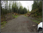 Gate & Parking |
 Hiking The Road |
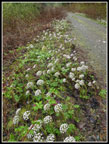 Lined With Coltsfoot |
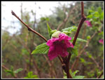 Salmonberry Flower |
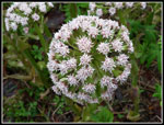 Coltsfoot Close Up |
 Some Views |
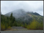 Cloudy View Ahead |
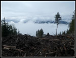 Clouds Fill Valley |
 Trees Through Clouds |
 More Views |
 Straight Ahead |
 Spectacular Clouds |
 Towards Lake |
 End Of The Road |
 Down Logs |
 More Down Logs |
 Turn Right |
 Tower Is In Sight |
 Trail To Summit |
 Yellow Violets |
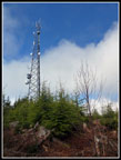 Summit Tower |
 Take Off Ramp |
 Lake Cavanaugh |
 Route Ahead |
 Frogville |
 Back In Clouds |
 Getting Foggier |
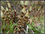
 Skunk Cabbage |
 Real Summit |
 Heading Back |
 It's Getting Darker |
 Still No Views |
 Not Clearing Yet |
 Below The Clouds |
 River & Highway |
 View Of Valley |
 Horsetails |
 Coltsfoot Again |
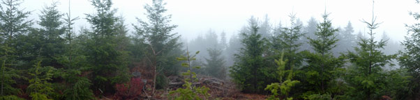 Frailey Mountain Real Summit Panorama |
Trips - 2019
Home