9-21-19
I
first hiked up Mt. David in 2001. I was not sure I could hike 14 miles
with 5100' of elevation gain in one day. I did and I had a great time.
One year later I invited Gary to come along. We had a great time. Our
most recent trip up David in 2014 was my 6th and Gary's 5th. Eighteen
years after my first ascent I was hoping I was still up for such a long
day. Our trips have all been in late summer or early fall as the
colorful leaf show is another factor to look forward to. It is a long
drive and a long hike. I was up at 4:00 am and on the road at 4:48 am.
We met in Bothell at 5:10 am and headed east. More traffic than
expected at that hour but not too bad. We cruised over Stevens Pass and
at Coles Corner turned north. The unpaved part of the White River Road
was in good condition. We arrived at the 2300' trailhead at 7:10 am. By
7:20 am we were on the trail. There were about 8-9 cars in the lot.
Most had wet windshields. We were probably the first day hikers. On
previous late September trips it had been in the mid 30s at the start.
This day was in the mid 40s.
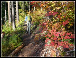
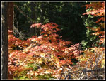
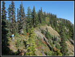
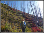
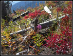
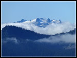
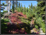
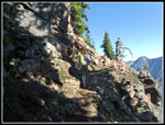
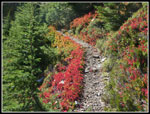
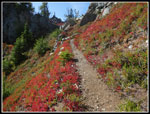
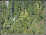
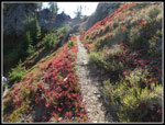
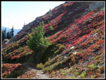
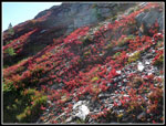
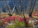
The trail begins with a mile of gentle downhill along the river. This is not much appreciated at the end of a long day as it means a mile of gentle uphill. We made good time. After the Mt. David - Panther Creek trails junction the route begins to climb. We began to see fall colors in the forest. Leaves were yellow and red. After a steady climb the route flattened a bit then began to climb again. There is one spot out in the open where the trail is pretty brushy. It was a little damp in the morning but dry in the afternoon. We were glad when the brush ended. There are also some logs down in this section. Some were just beg enough to cause up to stop to get over them. Others were just step across ones. The logs and brush were more an inconvenience than a big problem. After that we were back to a very nicely graded trail.
We gained just over 3000' in less than 3.5 miles from the junction. Though it was not hot we were sweating on the ascent. This steady climb is the cost paid to get to the high country on the upper ridge of Mt. David. We slowed down for a while then sped up and continued non stop to the summit. I was overheating a bit. I kept on my zip off pants legs and long sleeve shirt. On an earlier trip I received several hornet stings below the ridge. No problems this day. At the ridge top we stopped for a break. I went to shorts and short sleeves. I felt our time to the ridge was slower than past years but not too bad. In fact, at 2:10 it was 8 minutes faster than five years earlier. It was also 7 minutes faster than when I was 18 years younger. I think we took fewer photos this day but we were still happy with our time.
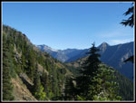
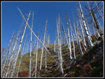
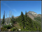
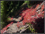
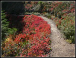
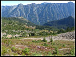
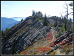
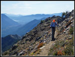
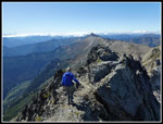
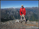
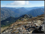
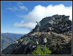
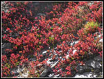
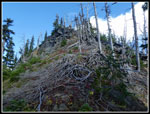
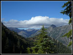
Now the fun began. The next 2.8 miles to the summit was mostly above tree line. Great views to the south then north then south again. We crossed the ridge top several times. There were also lots of huckleberry bushes with brightly colored leaves. The sky was completely blue. Barely any signs of clouds. Sunny and warm but not at all hot were the best possible conditions. To this point we had seen one person in the parking lot and nobody on the trail. It was still only 9:47 am when we started hiking again. We headed uphill through a burn. It was black with soot and ash on our last trip. Now it was mostly just silvered trees with brightly colored bushes grown back. It is now quite beautiful again.
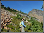
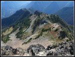
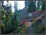
We climbed up the south side of the ridge and crossed over to the north. Lots of photos and views slowed us way down as it always has. We were already a mile high when we reached the ridge We still had more than 2000' to gain to the 7431' summit of Mt. David. The morning sun backlit the leaves nicely. One reason we look for a sunny day to do this trip. We took another break where the trail crosses right below a big rock field. While there a solo hiker caught up and passed us. Now the route begins short switchbacks up the slope to the ridge top. Lots of huckleberry leaves all along here.
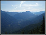
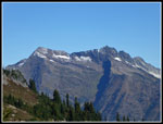
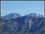
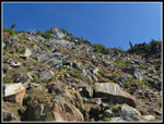
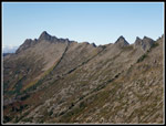
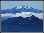
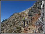
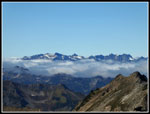
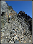
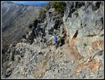
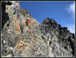
We reached the ridge top again and now had great views to the south. There was a sea of low clouds to the south. Mt. Daniel and Mt. Rainier was clear above the clouds. We could see down to Lake Wenatchee and to Dirty Face Peak right above it. Clark Mountain was visible to the north. We contoured below the ridge on the northeast side. One more climb to the ridge top and we dropped onto the other side. This quickly led to one of the most interesting spots on the route. The trail climbs up the steep hillside with a series of switchbacks. This is a bit of a gully as most everything that falls ends up falling down the center. The trail is narrow but fine most of the way. In the center it is narrower. The only problem is if someone above you knocks a rock down. The other hiker had cleared the route and we had no problem hiking up.
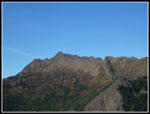
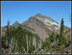
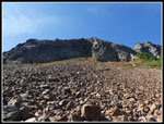
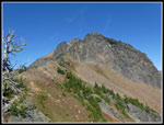
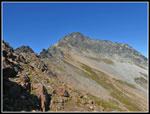
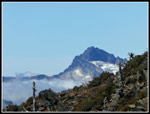
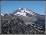
finally we crossed the top and the route climbed a bit, dropped a couple switchbacks, traversed a bit then began the final climb to the ridge top for the last time. We had seen a couple hikers behind us with a dog since not long after we took our last break. They would seem close behind then disappear again. We did not see them again until well after we reached the summit. The last part is a bit steeper than most of the route. Under the summit the trail peters out. There is a bit of a route heading straight up but it is not very distinct. That is the correct choice. Once up some looser rocks we reached the base of the final section tot he summit. This is a narrow obvious track that was blasted out when the lookout building was built. There is some exposure but the footing is great. In just a couple minutes we were on top. The blasted flat spot for the lookout is plenty big for a dozen or more folks. There was just the one solo hiker on top. From the top we had the first view of Glacier peak. It was some fresh snow on the south side.
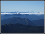
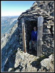
To the west we could now see that there were a lot of clouds near and just west of the Cascade Crest were under low clouds. Sloan Peak rose above the clouds. The Monte Cristo peaks were also in the open. The high summit of David provides great views in all directions. We arrived on top at 12:18 pm. Jut under 5 hours to the summit. We barely averaged one mile per hour after reaching the ridge top. Enjoying the high ridge walk is a lot more fun for s than setting a fast time to the summit. We wanted to be down before the 7:08 pm sunset and we arrived at the summit early enough for a nice long summit stay. There was very little wind. Conditions were about perfect for a long stay. The two guys with the dog arrived later. Before leaving we made the usual visit to the other side of the summit where the rock outhouse sits. It is made of piled rock slabs. A very distinctive building. Step out of it and turn right one big step and it is a several thousand foot vertical fall. Very impressive. Far below in the Indian Creek Valley there are larch trees. We could see just a few of them have started to turn golden.
At 1:40 pm we started down. The narrow blasted section is a little more interesting going down. We dropped through the short rocky section to the real trail and met one more hiker. He was waiting for his friend to catch up. We pointed him to the summit route. After we dropped off the ridge top we met his friend. He was the fifth and last person we saw this day. Not much of a crowd on such a fine day. The last two guys actually caught up and passed us on the last steep descent to the river. We were still pretty slow as the ridge hiking back to where we finally left the ridge is such fun. We made sure to make the most of our time and still get down before dark.
Our last break was at the last point on the ridge top. Now we had the 3000' descent to look forward to. After 5600' of gain and 2800' of loss this is not so much fun. Though we made much better time down than up the descent seemed to go on and on and on. My feet and knees were feeling it near the bottom. We were looking forward to reaching that last gently uphill mile+ section. That part was much slower than in the morning. We reached the trailhead at 6:08 pm. That was two hours after leaving the ridge top. We were down one full hour before sunset.
One other reason for this trip was a chance to dine at the new 59er Diner. We often did before it burned down. Now, about a year after it reopened we stopped for dinner. At 7:00 pm it was busy enough for us to have to wait for a table. We finally reached the Bothell Park & Ridge at about 9:20 pm. I was home by 9:50 pm.
This was a terrific trip. The weather could not have been better. Clouds did come in after we left the summit but we had the whole morning and early afternoon to enjoy the spectacular views. Spectacular they are. The Ridge walk is between 5200' and the 7431' summit. Among the best ones in the Cascades. The leaf color show was near to its peak. It was well worth getting up at 4:00 am and getting home at 9:50 pm. I was sore the next day but that too was not bad. My knees can still take 5800' of pounding in one day. Gary is a little older than me and he did pretty will too. I hope we can still do this hike in another 5 or even 10 years. I expect we have at least one more trip up Mt. David in our future.
Click on thumbnails to get
larger pictures.
Trips - 2019
Home
The trail begins with a mile of gentle downhill along the river. This is not much appreciated at the end of a long day as it means a mile of gentle uphill. We made good time. After the Mt. David - Panther Creek trails junction the route begins to climb. We began to see fall colors in the forest. Leaves were yellow and red. After a steady climb the route flattened a bit then began to climb again. There is one spot out in the open where the trail is pretty brushy. It was a little damp in the morning but dry in the afternoon. We were glad when the brush ended. There are also some logs down in this section. Some were just beg enough to cause up to stop to get over them. Others were just step across ones. The logs and brush were more an inconvenience than a big problem. After that we were back to a very nicely graded trail.
We gained just over 3000' in less than 3.5 miles from the junction. Though it was not hot we were sweating on the ascent. This steady climb is the cost paid to get to the high country on the upper ridge of Mt. David. We slowed down for a while then sped up and continued non stop to the summit. I was overheating a bit. I kept on my zip off pants legs and long sleeve shirt. On an earlier trip I received several hornet stings below the ridge. No problems this day. At the ridge top we stopped for a break. I went to shorts and short sleeves. I felt our time to the ridge was slower than past years but not too bad. In fact, at 2:10 it was 8 minutes faster than five years earlier. It was also 7 minutes faster than when I was 18 years younger. I think we took fewer photos this day but we were still happy with our time.
Now the fun began. The next 2.8 miles to the summit was mostly above tree line. Great views to the south then north then south again. We crossed the ridge top several times. There were also lots of huckleberry bushes with brightly colored leaves. The sky was completely blue. Barely any signs of clouds. Sunny and warm but not at all hot were the best possible conditions. To this point we had seen one person in the parking lot and nobody on the trail. It was still only 9:47 am when we started hiking again. We headed uphill through a burn. It was black with soot and ash on our last trip. Now it was mostly just silvered trees with brightly colored bushes grown back. It is now quite beautiful again.
We climbed up the south side of the ridge and crossed over to the north. Lots of photos and views slowed us way down as it always has. We were already a mile high when we reached the ridge We still had more than 2000' to gain to the 7431' summit of Mt. David. The morning sun backlit the leaves nicely. One reason we look for a sunny day to do this trip. We took another break where the trail crosses right below a big rock field. While there a solo hiker caught up and passed us. Now the route begins short switchbacks up the slope to the ridge top. Lots of huckleberry leaves all along here.
We reached the ridge top again and now had great views to the south. There was a sea of low clouds to the south. Mt. Daniel and Mt. Rainier was clear above the clouds. We could see down to Lake Wenatchee and to Dirty Face Peak right above it. Clark Mountain was visible to the north. We contoured below the ridge on the northeast side. One more climb to the ridge top and we dropped onto the other side. This quickly led to one of the most interesting spots on the route. The trail climbs up the steep hillside with a series of switchbacks. This is a bit of a gully as most everything that falls ends up falling down the center. The trail is narrow but fine most of the way. In the center it is narrower. The only problem is if someone above you knocks a rock down. The other hiker had cleared the route and we had no problem hiking up.
finally we crossed the top and the route climbed a bit, dropped a couple switchbacks, traversed a bit then began the final climb to the ridge top for the last time. We had seen a couple hikers behind us with a dog since not long after we took our last break. They would seem close behind then disappear again. We did not see them again until well after we reached the summit. The last part is a bit steeper than most of the route. Under the summit the trail peters out. There is a bit of a route heading straight up but it is not very distinct. That is the correct choice. Once up some looser rocks we reached the base of the final section tot he summit. This is a narrow obvious track that was blasted out when the lookout building was built. There is some exposure but the footing is great. In just a couple minutes we were on top. The blasted flat spot for the lookout is plenty big for a dozen or more folks. There was just the one solo hiker on top. From the top we had the first view of Glacier peak. It was some fresh snow on the south side.
To the west we could now see that there were a lot of clouds near and just west of the Cascade Crest were under low clouds. Sloan Peak rose above the clouds. The Monte Cristo peaks were also in the open. The high summit of David provides great views in all directions. We arrived on top at 12:18 pm. Jut under 5 hours to the summit. We barely averaged one mile per hour after reaching the ridge top. Enjoying the high ridge walk is a lot more fun for s than setting a fast time to the summit. We wanted to be down before the 7:08 pm sunset and we arrived at the summit early enough for a nice long summit stay. There was very little wind. Conditions were about perfect for a long stay. The two guys with the dog arrived later. Before leaving we made the usual visit to the other side of the summit where the rock outhouse sits. It is made of piled rock slabs. A very distinctive building. Step out of it and turn right one big step and it is a several thousand foot vertical fall. Very impressive. Far below in the Indian Creek Valley there are larch trees. We could see just a few of them have started to turn golden.
At 1:40 pm we started down. The narrow blasted section is a little more interesting going down. We dropped through the short rocky section to the real trail and met one more hiker. He was waiting for his friend to catch up. We pointed him to the summit route. After we dropped off the ridge top we met his friend. He was the fifth and last person we saw this day. Not much of a crowd on such a fine day. The last two guys actually caught up and passed us on the last steep descent to the river. We were still pretty slow as the ridge hiking back to where we finally left the ridge is such fun. We made sure to make the most of our time and still get down before dark.
Our last break was at the last point on the ridge top. Now we had the 3000' descent to look forward to. After 5600' of gain and 2800' of loss this is not so much fun. Though we made much better time down than up the descent seemed to go on and on and on. My feet and knees were feeling it near the bottom. We were looking forward to reaching that last gently uphill mile+ section. That part was much slower than in the morning. We reached the trailhead at 6:08 pm. That was two hours after leaving the ridge top. We were down one full hour before sunset.
One other reason for this trip was a chance to dine at the new 59er Diner. We often did before it burned down. Now, about a year after it reopened we stopped for dinner. At 7:00 pm it was busy enough for us to have to wait for a table. We finally reached the Bothell Park & Ridge at about 9:20 pm. I was home by 9:50 pm.
This was a terrific trip. The weather could not have been better. Clouds did come in after we left the summit but we had the whole morning and early afternoon to enjoy the spectacular views. Spectacular they are. The Ridge walk is between 5200' and the 7431' summit. Among the best ones in the Cascades. The leaf color show was near to its peak. It was well worth getting up at 4:00 am and getting home at 9:50 pm. I was sore the next day but that too was not bad. My knees can still take 5800' of pounding in one day. Gary is a little older than me and he did pretty will too. I hope we can still do this hike in another 5 or even 10 years. I expect we have at least one more trip up Mt. David in our future.
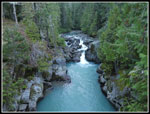 White River & Falls |
 First Leaf Color |
 Bright Against Dark |
 Views From Ridge Top |
 Gary On Ridge Top |
 Distant Whittier Peak |
 Silvered Snags |
 Huckleberry Color |
 Fireweed |
 Dirty Face Peak |
 First Summit Sighting |
 Summit From Ridge |
 Mt. Daniel Over Clouds |
 Color Show Begins |
 Backlit Beauty |
 Trail Lined In Red |
 Narrow Trail |
 Clark Mountain |
 Rock Field |
 Gary On Trail |
 More Red Leaves |
 Meadow Below |
 Summit Behind Bump |
 7 Finger Jack & Maude |
 Trail On Ridge |
 Great Color |
 Climbing Up Gully |
 View Of Trail |
 Approaching Summit |
 High On Ridge |
 Whittier Ridge |
 View To The South |
 Mt. Daniel Again |
 Nearing Summit |
 Monte Cristo Peaks |
 Sloan Peak |
 Blasted Section |
 Glacier Peak |
 Heading To Other Summit |
 Stone Ig"loo" |
 Larch Trees Changing |
 Jim On Summit |
 Gary Descending |
 Me On Blasted Section |
 Gary Ahead |
 Rounding Rock |
 Back To The Color |
 Best Color Spot |
 Wow! |
 Close Up Look |
 Solo Hiker |
 Roots? |
 Burn Colors |
 Time To Leave Ridge |
Trips - 2019
Home