3-30-19
I
was looking for a good long leg
stretching hike with minimal snow. Time for a return to Wallace Falls
State Park. Initially, I was planning the usual hike to the falls then
over to Wallace Lake and down the Greg Ball Trail. I arrived at the
trailhead at about 8:25 am to find the lot about 65% full. I always
expect an overflow crowd by mid morning but this was the most cars I
have seen this early. My thoughts of a mostly empty trail to the falls
was not looking likely. The forecast was for a 20% chance of rain and
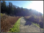
partly cloudy sky. It was completely clear. I started up the trail at
8:35 am. The low sun was blinding at the trail starts out going to the
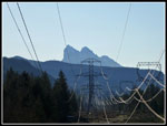
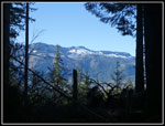
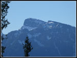
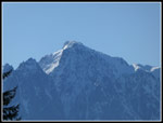
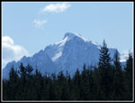
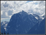
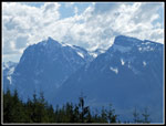
east. I had the usual good views of Mt. Baring and Mts. Index and
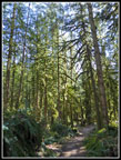
Persis. Quickly the way left the open power line corridor and headed
into forest. I chose the railroad grade and considered just taking the
Greg Ball Trail to Wallace Lake and then going on to Jay Lake. That
would be a lot less crowded than the falls trail was sure to be.
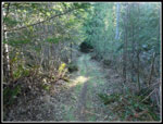
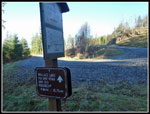
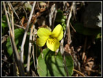
Last week I saw my first wildflowers of the year, a few patches of yellow violets. I looked carefully but saw none along the trail. As I neared the junction with the trail over to the DNR logging road to the lake I thought about going up that route. It is longer and mostly out in the open sunshine. The road is gravel and harder on feet than the dirt trail to the lake. At the junction I turned left and headed towards the logging road. This route is 6.5 miles to Wallace Lake from the trailhead. The Greg Ball Trail and the railroad grade is about 4.75 miles. What's an extra 1.75 miles?
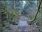
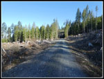
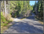
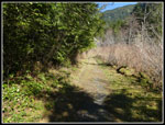
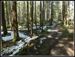
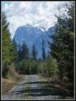
When I first hiked to Wallace Lake on 2-18-89 the route was on an old logging road that had turned to a grassy road/trail. Trees had formed a canopy overhead. The tread was soft. There were no views out from the forested trail. Then the road was widened and heavily graveled for new logging. I had only hiked the road once since and it was very thick gravel. Difficult to walk. I had forgotten that the old grassy road still exists for .90 miles where the wide gravel road is reached. The road is the route for bicycles as the other trails are closed to bikes. I reached the gravel road to find it is much easier to walk now. Truck tires have ground in or kicked off much of the gravel. I was pleasantly surprised. The road was in the sunshine. It was only about 40 degrees when I started but it was very comfortable in the sunshine.
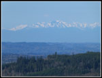
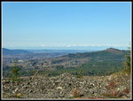
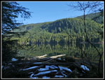
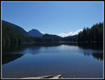
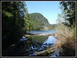
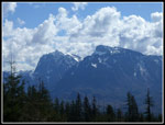
The net elevation gain to the lake is 1514' over 6.5 miles. It is very gently graded. I made very good time on the road. Trees have begun to grow back but there are some very good views out. In places I could see Index and Persis plus much of the ridge across the Skykomish River Valley. The Olympic Mountains were in sight but it was a little hazy. My GPS recorded 3.2 mph moving speed on the 5 uphill miles from the railroad grade to the lake. That is very good speed for me. I reached the lake at 10:54 am. I took 2:19 to hike 6.5 miles. The snow is almost gone. Just a few small patches at the lake outlet. I saw two groups near the trailhead. I saw another hiker on the railroad grade. I saw one more at the top of the Greg Ball Trail. Not much of a crowd on trails away from Wallace Falls.
I took the trail around the lake. No snow here now. I expected the inlet creek to be running making it difficult to reach Pebble Beach at the lake inlet. To my surprise, it was dry. An easy walk along the rocky creek bed to the lake shore. I arrived at Pebble Beach at 11:08 am. The lake was not as high as it often is in the spring. There was plenty of dry gravel. Views down the lake were excellent. The sunshine made it warm enough. My lunch break lasted until 11:30 am. I headed up the trail to Jay Lake. The trail was bare dirt about half way where the snow started immediately. In 50' it went from bare to snow covered. The snow was not deep. I followed boot prints from there to the lake. I arrived at Jay Lake at 11:48 am. The sign leaving Wallace Lake said it was 1 mile. The GPS said .80 miles to the campsites in the middle of the lake. I stopped at one campsite and it was snow free in the forest. The road/trail is more open and snow covered.
I took a short break at Jay Lake and headed back. At the Wallace Lake inlet I went back to Pebble Beach and found no one there again. This break was shorter. I did notice big bright sun sparkles in the lake that I caught on video. I often see small sparkles but these were much bigger. The biggest change is on my first stop there were just a few small clouds in the distance. Now there were big and very tall clouds building. They made for good photos. I now had completed 9 miles. This was going to be a long day. I headed back at 12:18 pm. I hiked back along the lake passing two groups near the shore. Where the old road up to the lake comes in I took a short detour. The road drops down and now at the same point a road heads uphill. It goes to a recent logging area. I checked this out a year ago. The road climbed about 80' to a landing with views up and down the Skykomish Valley. Index and Persis now had clouds above them. This is a very nice viewpoint. I retraced my steps and continued to the outlet.
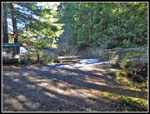
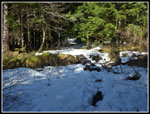
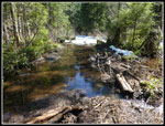
Time for one more detour. The route from the falls reaches a stop .25 miles from the lake where beavers have dammed a creek that created a lake on the old roadbed/trail. It can be very challenging to get across at high water. I wanted to see if I could get across with dry feet now. I met two hikers who were just finishing crossing it when I arrived. Small logs have been placed to create a dry walkway along the side of the lake. The route is now much better. It still could be challenging after heavy rains when the water is even higher.
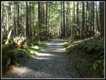
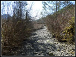
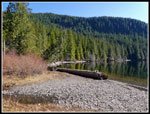
I went back to the Wallace Lake outlet and headed out. I complained about thick large gravel placed on this road/trail last year. It is just as bad now. Sharp rocks that are hard on the feet. A really stupid thing to have done to a nice old forest road/trail. The main DNR road to the lake is much easier to walk on. I reached the DNR road and turned right. I soon reached the Greg Ball Trail. I had planned to go down it but the bright sunshine and views on the road sounded better than the soft dirt trail through thick forest. At least for this day. A long dark winter makes a sunny spring day feel that much better. I made very good time going down. I saw some folks at the top of the Greg Ball, two more hikers coming up, and two bikers coming up. That was it until back on the railroad grade. I made even better time going down. The only slowdowns were for all the photo opportunities. I also saw more yellow violets in bloom.
I reached the trailhead at 3:04 pm. With my short side trips I ended up right at 17 miles with 1800' of elevation gain. My moving speed ended at 3.2 mph. I paused the GPS for my long lunch break. With my numerous photo stops and a few food and water breaks by average speed dropped to 2.7 mph. Still, that is very fast for me. The smooth easy grade made for a fast trip.
My plans started as a falls - lake loop trip. That changed to taking the road up. That changed again to taking the road down. I managed to take a hike to the lake that can be as short as 4.1 miles and increased it to 6.5 miles each way. add in the Jay Lake addition and my two side trips at the lake and I pushed it to 17 miles. As expected, the parking lot was a packed zoo at 3:04 pm when I returned. on my drive out I saw roughly 40 more cards along the road. Much of the road has "no parking "signs so folks now park even farther away. 10 of the cars were parked beyond where the May Creek Road comes in. With cars parked right up to the fog line on the road people were walking in the car lane. I had to drive in the left lane for quite a ways to get around them all. This is just nuts. Even with the crowd I had a quiet hike with just enough company to keep it fun but never close to being crowded. It turned out to be a really long and fun early spring hike.
Click on thumbnails to get
larger pictures.
Trips - 2019
Home
Last week I saw my first wildflowers of the year, a few patches of yellow violets. I looked carefully but saw none along the trail. As I neared the junction with the trail over to the DNR logging road to the lake I thought about going up that route. It is longer and mostly out in the open sunshine. The road is gravel and harder on feet than the dirt trail to the lake. At the junction I turned left and headed towards the logging road. This route is 6.5 miles to Wallace Lake from the trailhead. The Greg Ball Trail and the railroad grade is about 4.75 miles. What's an extra 1.75 miles?
When I first hiked to Wallace Lake on 2-18-89 the route was on an old logging road that had turned to a grassy road/trail. Trees had formed a canopy overhead. The tread was soft. There were no views out from the forested trail. Then the road was widened and heavily graveled for new logging. I had only hiked the road once since and it was very thick gravel. Difficult to walk. I had forgotten that the old grassy road still exists for .90 miles where the wide gravel road is reached. The road is the route for bicycles as the other trails are closed to bikes. I reached the gravel road to find it is much easier to walk now. Truck tires have ground in or kicked off much of the gravel. I was pleasantly surprised. The road was in the sunshine. It was only about 40 degrees when I started but it was very comfortable in the sunshine.
The net elevation gain to the lake is 1514' over 6.5 miles. It is very gently graded. I made very good time on the road. Trees have begun to grow back but there are some very good views out. In places I could see Index and Persis plus much of the ridge across the Skykomish River Valley. The Olympic Mountains were in sight but it was a little hazy. My GPS recorded 3.2 mph moving speed on the 5 uphill miles from the railroad grade to the lake. That is very good speed for me. I reached the lake at 10:54 am. I took 2:19 to hike 6.5 miles. The snow is almost gone. Just a few small patches at the lake outlet. I saw two groups near the trailhead. I saw another hiker on the railroad grade. I saw one more at the top of the Greg Ball Trail. Not much of a crowd on trails away from Wallace Falls.
I took the trail around the lake. No snow here now. I expected the inlet creek to be running making it difficult to reach Pebble Beach at the lake inlet. To my surprise, it was dry. An easy walk along the rocky creek bed to the lake shore. I arrived at Pebble Beach at 11:08 am. The lake was not as high as it often is in the spring. There was plenty of dry gravel. Views down the lake were excellent. The sunshine made it warm enough. My lunch break lasted until 11:30 am. I headed up the trail to Jay Lake. The trail was bare dirt about half way where the snow started immediately. In 50' it went from bare to snow covered. The snow was not deep. I followed boot prints from there to the lake. I arrived at Jay Lake at 11:48 am. The sign leaving Wallace Lake said it was 1 mile. The GPS said .80 miles to the campsites in the middle of the lake. I stopped at one campsite and it was snow free in the forest. The road/trail is more open and snow covered.
I took a short break at Jay Lake and headed back. At the Wallace Lake inlet I went back to Pebble Beach and found no one there again. This break was shorter. I did notice big bright sun sparkles in the lake that I caught on video. I often see small sparkles but these were much bigger. The biggest change is on my first stop there were just a few small clouds in the distance. Now there were big and very tall clouds building. They made for good photos. I now had completed 9 miles. This was going to be a long day. I headed back at 12:18 pm. I hiked back along the lake passing two groups near the shore. Where the old road up to the lake comes in I took a short detour. The road drops down and now at the same point a road heads uphill. It goes to a recent logging area. I checked this out a year ago. The road climbed about 80' to a landing with views up and down the Skykomish Valley. Index and Persis now had clouds above them. This is a very nice viewpoint. I retraced my steps and continued to the outlet.
Time for one more detour. The route from the falls reaches a stop .25 miles from the lake where beavers have dammed a creek that created a lake on the old roadbed/trail. It can be very challenging to get across at high water. I wanted to see if I could get across with dry feet now. I met two hikers who were just finishing crossing it when I arrived. Small logs have been placed to create a dry walkway along the side of the lake. The route is now much better. It still could be challenging after heavy rains when the water is even higher.
I went back to the Wallace Lake outlet and headed out. I complained about thick large gravel placed on this road/trail last year. It is just as bad now. Sharp rocks that are hard on the feet. A really stupid thing to have done to a nice old forest road/trail. The main DNR road to the lake is much easier to walk on. I reached the DNR road and turned right. I soon reached the Greg Ball Trail. I had planned to go down it but the bright sunshine and views on the road sounded better than the soft dirt trail through thick forest. At least for this day. A long dark winter makes a sunny spring day feel that much better. I made very good time going down. I saw some folks at the top of the Greg Ball, two more hikers coming up, and two bikers coming up. That was it until back on the railroad grade. I made even better time going down. The only slowdowns were for all the photo opportunities. I also saw more yellow violets in bloom.
I reached the trailhead at 3:04 pm. With my short side trips I ended up right at 17 miles with 1800' of elevation gain. My moving speed ended at 3.2 mph. I paused the GPS for my long lunch break. With my numerous photo stops and a few food and water breaks by average speed dropped to 2.7 mph. Still, that is very fast for me. The smooth easy grade made for a fast trip.
My plans started as a falls - lake loop trip. That changed to taking the road up. That changed again to taking the road down. I managed to take a hike to the lake that can be as short as 4.1 miles and increased it to 6.5 miles each way. add in the Jay Lake addition and my two side trips at the lake and I pushed it to 17 miles. As expected, the parking lot was a packed zoo at 3:04 pm when I returned. on my drive out I saw roughly 40 more cards along the road. Much of the road has "no parking "signs so folks now park even farther away. 10 of the cars were parked beyond where the May Creek Road comes in. With cars parked right up to the fog line on the road people were walking in the car lane. I had to drive in the left lane for quite a ways to get around them all. This is just nuts. Even with the crowd I had a quiet hike with just enough company to keep it fun but never close to being crowded. It turned out to be a really long and fun early spring hike.
 Bright Sun At Start |
 Mt. Baring |
 Old Logging Road |
 Fully Enclosed Trail |
 First View Out |
 DNR Road Junction |
 Clear Cut Along Road |
 Mt. Persis View |
 Mt. Index View |
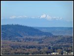 Olympic Mountains |
 Old Off Trail Perch |
 View To The West |
 Wide Open Views |
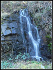 Small Waterfall |
 Turn Off To Lake |
 Old Road To Lake |
 Lake Outlet |
 Reflection In Lake |
 Route Around Lake |
 Dry Inlet Creek Bed |
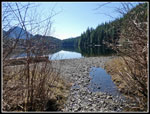 Pebble Beach |
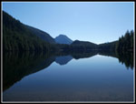 Wallace Lake Reflected |
 Pebbles On The Beach |
 Distant Snowy Peak |
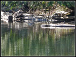 Canada Geese |
 Trail To Jay Lake |
 Now Snowy Trail |
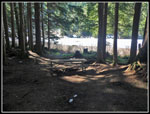 Campsite At Lake |
 Back At Wallace Lake |
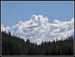 Big Distant Clouds |
 Index From Clear Cut |
 Index & Persis |
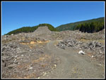 New Clear Cut |
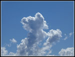 Puffy Clouds |
 Second Detour |
 Wallace Lake Outlet |
 Greg Ball Trail |
 Yellow Violet |
 Last Mountain View |
 Road To Index |
 Mossy Trees |
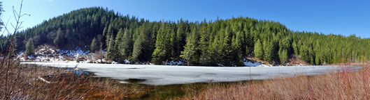 Here Is A Panorama Shot Of Jay Lake |
Trips - 2019
Home