Chuckanut
Mountain
2-09-20On
Sunday Gary and John joined me for a winter/spring favorite hike. It
looked to be a rare sunny day this year. Mt. Rainier was closed down by
landslides on Highway 410, the Carbon River Road, and the main
Nisqually Entrance. The 410 side closed Crystal Mountain. With the
closures and the sun many hiking, snowshoeing, or skiing destinations
would be packed. I thought a trip to Chuckanut Mountain was in order.
Gary did this trip with me in 2016.
John had never done it. My first visit was in 2015. This would be my
fifth. We met At Ash Way Park and Ride at 7:15 am and headed north. It
was quite cloudy though the updated morning forecast called for mostly
sunny. Hmm... We left I-5 at exit 246 and headed west to the North
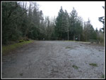
Chuckanut Mountain Trailhead. We arrived at 8:20 am to find only a few
cars in the lot. Thinks were looking good. We were on the trail at 8:24
am.
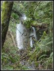
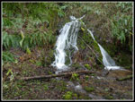
Last January I arrived to find all but a couple parking spaces full at about the same time. A WTA work party was replacing several boardwalks right near the beginning of the trail. They were finished and in great shape this day. It was cold at the start. Temperature in the low 30s. It was completely overcast. Not what we expected. Still, it was not raining. It had rained almost every day of the year so far. We quickly reached the Interurban Trail. The old railroad grade makes a good trail. I was hoping the waterfall next to the trail would be roaring and it was. Not huge but more water than on any previous visit. We stopped for photos. There are lots of junctions on the trails. Most have signs and some have big maps. Near the start several have no signs. I map is very helpful. I was pretty sure of the way but we still consulted the gps maps to be sure.
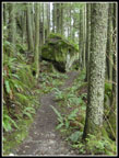
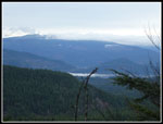
I was happy when we started to gain elevation as it helped to warm us up. There was varying degrees of mud on our route. Never too bad and there was none for much of our route. Still, it was a bit oozy in places. We passed several groups of runners early on. Then the crowds, such as they were, went away. For much of the day we saw very few people. I was a little afraid that a mudslide on Chuckanut Drive would have closed the trail to Oyster Dome and meant bigger crowds on our route. It turned out to be the opposite. We took a short break at the turn off for the Chuckanut Ridge Trail. This is one of my favorite routes on the Mountain. We climbed steeply to the top of the narrow forested ridge. There is a viewpoint out to part of Bellingham and to Mt. Baker. I was afraid that Baker would be lost in the clouds. The sky was white but the mountain was in the clear. We had a very nice view of it.
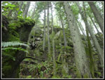
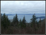
After that the views are lost to the thick forest. Saltwater is not far away but we could only get a few glimpses out to it to the west. The ridge has a lot of ups and downs. As it gains elevation up to the Cyrus Gates Overlook each up leads to a slightly smaller down. The three or so miles of the ridge seem to go on and on forever. We passed the Lower Ridge junction and continued on. The then new unmarked trail I found in 2015 was still unmarked. It drops to the road. I found that out when I took a wrong turn that time. The correct trail stays on the ridge until it reaches the road coming up from Chuckanut Drive. The ridge trail continues to the high point just above the Gates Overlook. I have done it once. We took the road the very short distance to the overlook. On all my previous visits there were lots of cars and some people when I arrived. Not so this day. The slide across Chuckanut Drive blocked access to the road. It allowed us to have total solitude at the overlook.
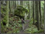
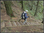
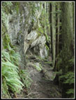
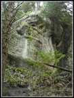
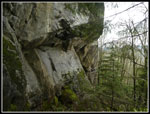
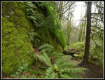
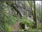
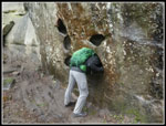
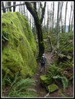
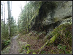
It was quite chilly but there was no wind at all. We put on more layers and sat down for lunch. It was only 11:18 when we arrived. Some trees had fallen during recent wind storms and had been cut up. We noticed a little snow below the overlook on the west side. Just a tiny bit. We did not see any other snow on our trip. John took a short trip up to the highpoint on the ridge and returned. At 11:44 we headed on. Next came the steep descent on the Rock Trail. This is a highlight of the trip for me. Even better with the road closure as we saw nobody on it. The steps are impressively steep as they took us down the near cliff like slope. After than the trail contours right below the cliffs. The rocky cliffs are made of sandstone. That is something seldom seen in Washington State. That make is even more interesting. The pock market rock looks like it should be located in the southwest.
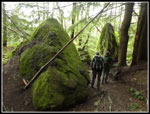
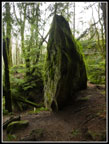
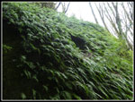
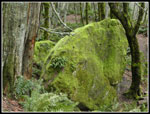
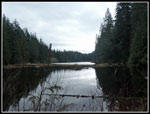
We took quite a bit of time hiking the 1.2 mile trail. Many photos were taken. In addition to the cliffs there are big boulders that have crashed down from above and now are covered with moss and ferns. They make for quite a sight. We finally reached the junction with the South Lost Lake Trail at 12:30 pm. 46 minutes to hike 1.2 miles is not fast but was very enjoyable. The South Lost Lake Trail is pretty flat and prone to mud. It was muddy in spots but not as bad as I expected. We soon saw Lost Lake below through the trees. At the junction we turned right towards the lake. Gary and I went all the way past the outlet and a short way up the east side of the lake to get a good view. All around the outlet it is swampy. Especially so after all the recent rain. I have found that at the star to of the water it is possible to head right for the lake. We did so. Last January it was dry as I poked through the trees to a small open viewpoint of the lake. This time it was more sporting. There was a big puddle right where we pushed through the trees. I did so and jumped the puddle. John put his hiking pole into it to check the depth. It was almost two feet deep. I am glad I did not fall in.
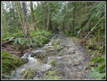
There was only room for two and we took turns getting a look down the lake. We then headed back. Once on the trail we saw a woman coming back across the wet logs needed to cross the swamp. One of only a few people seen over the last several hours. Back at the South Lost Lake Trail we turned right and continued towards the trailhead. This trail climbs and drops and climbs and drops. Much of the way the trail is up against cliffs. Above that is the ridge top we hiked up earlier. In places it leaves the steep slope before coming back again. We played leap frog with two other hikers as they passes us and we passed them before they passed us one last time. There is another waterfall that is right against the trail. This one was gushing. The creek then runs down the trail for a ways. We were able to cross it easily.
Towards the end we passed several more trails. At long last we completed our loop at the spot where we had turned on to the Chuckanut Ridge Trail. Now it was just retracing our morning route. As expected we began to see more people in the last mile or so. Even then it was not very crowded. We arrived back at the car at 2:37 pm. The lot was now mostly full though there were a number of open spots.
This day turned out very well. On the negative side we had a few small blue sucker holes in the sky near the end but it was almost entirely an overcast day. It was cold not not at all windy. It finally reached the low 40s at the end but was in the 30s almost all day. The positives far outweighed the negatives. It never rained. We had morning views of Mt. Baker. The trail was eerily empty. The closed road provided total solitude at the overlook and on the Rock Trail. We avoided the recent floods and wet snow. This trip will remain in my annual rotation for a long time. It is great for being snow free much of the winter and for some great spring wildflowers. For the day we hiked about 12 miles with 2700' of elevation gain though the highest point on the trail was 1840'. All that and I was home well before my 5:00 pm goal.
Click on thumbnails to get
larger pictures.
Trips - 2020
Home
Last January I arrived to find all but a couple parking spaces full at about the same time. A WTA work party was replacing several boardwalks right near the beginning of the trail. They were finished and in great shape this day. It was cold at the start. Temperature in the low 30s. It was completely overcast. Not what we expected. Still, it was not raining. It had rained almost every day of the year so far. We quickly reached the Interurban Trail. The old railroad grade makes a good trail. I was hoping the waterfall next to the trail would be roaring and it was. Not huge but more water than on any previous visit. We stopped for photos. There are lots of junctions on the trails. Most have signs and some have big maps. Near the start several have no signs. I map is very helpful. I was pretty sure of the way but we still consulted the gps maps to be sure.
I was happy when we started to gain elevation as it helped to warm us up. There was varying degrees of mud on our route. Never too bad and there was none for much of our route. Still, it was a bit oozy in places. We passed several groups of runners early on. Then the crowds, such as they were, went away. For much of the day we saw very few people. I was a little afraid that a mudslide on Chuckanut Drive would have closed the trail to Oyster Dome and meant bigger crowds on our route. It turned out to be the opposite. We took a short break at the turn off for the Chuckanut Ridge Trail. This is one of my favorite routes on the Mountain. We climbed steeply to the top of the narrow forested ridge. There is a viewpoint out to part of Bellingham and to Mt. Baker. I was afraid that Baker would be lost in the clouds. The sky was white but the mountain was in the clear. We had a very nice view of it.
After that the views are lost to the thick forest. Saltwater is not far away but we could only get a few glimpses out to it to the west. The ridge has a lot of ups and downs. As it gains elevation up to the Cyrus Gates Overlook each up leads to a slightly smaller down. The three or so miles of the ridge seem to go on and on forever. We passed the Lower Ridge junction and continued on. The then new unmarked trail I found in 2015 was still unmarked. It drops to the road. I found that out when I took a wrong turn that time. The correct trail stays on the ridge until it reaches the road coming up from Chuckanut Drive. The ridge trail continues to the high point just above the Gates Overlook. I have done it once. We took the road the very short distance to the overlook. On all my previous visits there were lots of cars and some people when I arrived. Not so this day. The slide across Chuckanut Drive blocked access to the road. It allowed us to have total solitude at the overlook.
It was quite chilly but there was no wind at all. We put on more layers and sat down for lunch. It was only 11:18 when we arrived. Some trees had fallen during recent wind storms and had been cut up. We noticed a little snow below the overlook on the west side. Just a tiny bit. We did not see any other snow on our trip. John took a short trip up to the highpoint on the ridge and returned. At 11:44 we headed on. Next came the steep descent on the Rock Trail. This is a highlight of the trip for me. Even better with the road closure as we saw nobody on it. The steps are impressively steep as they took us down the near cliff like slope. After than the trail contours right below the cliffs. The rocky cliffs are made of sandstone. That is something seldom seen in Washington State. That make is even more interesting. The pock market rock looks like it should be located in the southwest.
We took quite a bit of time hiking the 1.2 mile trail. Many photos were taken. In addition to the cliffs there are big boulders that have crashed down from above and now are covered with moss and ferns. They make for quite a sight. We finally reached the junction with the South Lost Lake Trail at 12:30 pm. 46 minutes to hike 1.2 miles is not fast but was very enjoyable. The South Lost Lake Trail is pretty flat and prone to mud. It was muddy in spots but not as bad as I expected. We soon saw Lost Lake below through the trees. At the junction we turned right towards the lake. Gary and I went all the way past the outlet and a short way up the east side of the lake to get a good view. All around the outlet it is swampy. Especially so after all the recent rain. I have found that at the star to of the water it is possible to head right for the lake. We did so. Last January it was dry as I poked through the trees to a small open viewpoint of the lake. This time it was more sporting. There was a big puddle right where we pushed through the trees. I did so and jumped the puddle. John put his hiking pole into it to check the depth. It was almost two feet deep. I am glad I did not fall in.
There was only room for two and we took turns getting a look down the lake. We then headed back. Once on the trail we saw a woman coming back across the wet logs needed to cross the swamp. One of only a few people seen over the last several hours. Back at the South Lost Lake Trail we turned right and continued towards the trailhead. This trail climbs and drops and climbs and drops. Much of the way the trail is up against cliffs. Above that is the ridge top we hiked up earlier. In places it leaves the steep slope before coming back again. We played leap frog with two other hikers as they passes us and we passed them before they passed us one last time. There is another waterfall that is right against the trail. This one was gushing. The creek then runs down the trail for a ways. We were able to cross it easily.
Towards the end we passed several more trails. At long last we completed our loop at the spot where we had turned on to the Chuckanut Ridge Trail. Now it was just retracing our morning route. As expected we began to see more people in the last mile or so. Even then it was not very crowded. We arrived back at the car at 2:37 pm. The lot was now mostly full though there were a number of open spots.
This day turned out very well. On the negative side we had a few small blue sucker holes in the sky near the end but it was almost entirely an overcast day. It was cold not not at all windy. It finally reached the low 40s at the end but was in the 30s almost all day. The positives far outweighed the negatives. It never rained. We had morning views of Mt. Baker. The trail was eerily empty. The closed road provided total solitude at the overlook and on the Rock Trail. We avoided the recent floods and wet snow. This trip will remain in my annual rotation for a long time. It is great for being snow free much of the winter and for some great spring wildflowers. For the day we hiked about 12 miles with 2700' of elevation gain though the highest point on the trail was 1840'. All that and I was home well before my 5:00 pm goal.
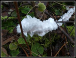 Hair Ice |
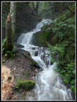 First Waterfall |
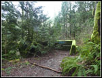 Old Trestle Site |
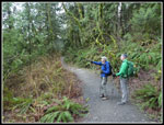 Gary & John |
 Second Waterfall |
 Big Rock |
 Steep Slope |
 Gary On Ridge Trail |
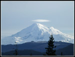 Mt. Baker |
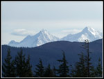 Twin Sisters |
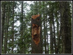 Snag Face? |
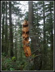 Another Face? |
 Another View |
 Empty Overlook |
 Overlook View |
 Descending Rock Trail |
 Along Cliffs |
 Sandstone Ciffs |
 Overhanging Rock |
 Shades Of Green |
 Vertical Rock |
 Moss & Ferns |
 Lots Of Ferns |
 Back To Cliffs |
 Headless Hiker |
 Really Mossy |
 Gary & Green Wall |
 Lost Lake |
 Another Waterfall |
 Trail Is A Creek |
 Trail Below Ridge |
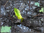 First Skunk Cabbage |
Trips - 2020
Home