6-27-20
With
rain on the west side of the
mountains i headed a little east to Easton and the trail up Mt. Baldy.
There were two trip reports on WTA from mid week so I was not expecting
it to be as little used as it used to be. It had been 5 years since me
last visit. I was out the door by 7:05 am. Hopefully early enough to
get a parking spot near the trailhead. Though the weather radar showed
no rain anywhere in Washington state it rained almost all the way to
Snoqualmie Pass. As I neared Easton there was a sucker hole of blue sky
to be seen. From Easton I drove to the Kachess Dam Road which quickly
turned to gravel. Under the powerlines and right on the narrow road to
the trailhead. My first visit was in October of 1994. Then the route to
the trailhead was going under the powerlines on a bad dirt road to a
five or six way intersection. The correct route ended up right along
Silver Creek. I doubt I saw anyone else for my first three or four
visits. Now the road is smooth and easy. There are only about a dozen
spaces near the start of the trail. After that, folks park along any
wide spot in the road. I arrived at about 8:25 am to find one last
spot. I was on my way a few minutes later.
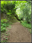
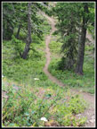
Two trails start from this spot. One goes up Silver Creek and one crosses the creek and heads up to the ridge top. From there the ridge climbs steeply up to a higher ridge at Para Point. Left drops then climbs to Thomas Mountain. Right drops and climbs to Mt. Baldy. The clouds were thick enough that I was not expecting much of a view this day. The forecast also included 10 -15 MPH winds with gusts up to 29 mph. I dropped to cross the creek and started the switchbacks. I quickly passed a group of four hikers at a switchback. The trail is pretty narrow in this section. I sped up as they started moving right after I passed them. Fortunately I pulled away and did not see them again on the way up. For future reflection when I read this report years from now, it is the time of the Covid pandemic and I wanted a hike with as few folks as possible. Safety first.
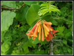
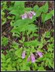
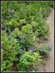
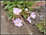
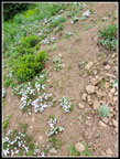
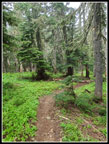
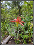
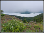
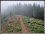
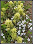
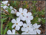
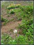
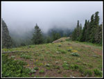
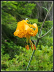
On my first visit I reached an active road and had to look closely for where the trail soon leaves it. I missed it and went too far up the road that day. It is no longer a problem. The road is now narrow and the trail is more obvious than the old road. I started seeing some wildflowers near the bottom and they continued most of the way up. I had not seen a tiger lily this year. That was rectified in the first quarter mile. There were quite a few honeysuckles flowers too. Some vanilla leaf, false Solomon's seal, starflower, and others were along the lower trail. When I could no longer hear or see the other group I slowed down a little. It was chilly at the start but the steady climbing had me warming up fast. I reached the ridge top junction with the Easton Ridge and Domerie Divide trails at about 9:06 am. I turned left on the flat ridge top on the Domerie Divide Trail. At 9:12 am I stopped at the viewpoint to zip off my pant legs. I was getting too hot. The viewpoint was open to a stiff cold wind. Clear views down to Kachess Lake and Lake Easton. Only white sky was above.
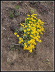
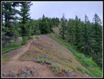
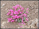
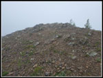
Now comes the fun part. The trail up to this point is a steady climb. A bit steep but no problem. Now it gets crazy steep. First it climbs a short bit and then makes a short descent. Now it is straight up. I have slipped a few times coming down and fallen on my rear. Even so, I had forgotten how steep it can be. It also has some loose dirt and small rocks. I set a steady pace heading up. At one switchback I passed two more guys heading up. As the route gets higher the flowers become more east side types. Some past prime arrowleaf balsamroot appeared. I saw a few arnica in bloom too. When I reached the spot where the ridge top and Baldy come into view Baldy was in the clouds. The now bare ground had phlox, penstemon, Columbia Lewisia, Larkspur, and more in bloom. I ground out the last bit of elevation to Para Point, arriving at 10:03 am. I climbed 2600' in just over 1 1/2 hours. The wind was blowing hard enough that I put on a jacket and clamped down the hood to keep my hat from flying away. I considered Thomas as it was likely to see fewer visitors but decided to turn right and head for Baldy.
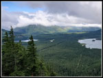
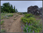
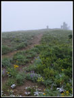
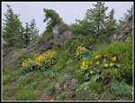
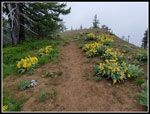
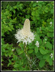
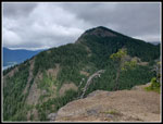
The ridge walk to Baldy has ups and down plus forest and meadows. Lake Cle Elum is now right below. The views out to Mts Daniel, Hinman, and Stuart were not to be this day. I could see down but not out. At open gaps in the ridge clouds blew through. It was probably in the low 40s but with the icy wind it felt like mid 30s. Such is early summer in Washington state. I had to put on gloves. The reddish penstemon growing in bare rocky soil was very colorful. I saw it on Koppen Mountain a week earlier. Lupine was mixed in with blooming balsamroot too. I looked for one anomaly I have only seen on this ridge. Balsamroot blooming right next to beargrass. My timing was good. A single beargrass was in bloom on the right side with a patch of blooming balsamroot on the left. I see beargrass west of the crest and balsamroot to the east. Here they grow together. Half way along a line runner with a dog passed me. When I reached the last low spot where the trail begins to climb up Baldy I passed a group of five heading down. That made for 4 groups passed on the way up for a total of 12 people. Not too bad at all.
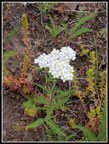
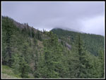
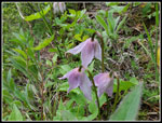
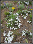
The old trail continues beneath Baldy and down to Domerie Peak. There was just a minimal boot path leading to the summit. Not any more. Now the trail winds around then heads straight up to the top. I did not see the old trail heading on. I reached the summit at 10:38 am. I took 2:08 to hike up four miles with just over 3100' of gain. Not too bad considering all the photos I took and my sow pace on the steep section. Views were the expected none at all. Even the lake right below was in and out of the clouds. I stayed only a few minutes then headed lower to get out of some of the wind. Time for a quick lunch. There are many wildflowers in bloom on the open slope below the summit. These included penstemon, several colors of phlox, balsamroot, Indian paintbrush, Columbia Lewisia, lupine, desert parsley, and more.
After taking photos of the flowers and finishing lunch the two guys I had passed earlier came up to the summit. I headed down at 10:55. As the vertical descent began to level off I spied an animal trail heading down the ridge towards Domerie Peak. A short way along it became a full trail. What was the main route is now so overgrown with plants that the start is hard to find. I have been to Domerie Peak and Baldy from the other direction one time on snowshoes. One day I need to continue down to Domerie from Baldy on dirt. Not this day. I took more flower photos on the ridge but kept up a good pacer. I passed a group of three women hikers and one other group on the ridge. Moving off the trail was easy. Back at Para Point I passed one more group then started the descent. It is not as steep as lower down but I had to be careful not to slip on the loose dirt. I passed several groups of one or two on the upper slopes.
When I reached the steep section I caught up with the group of five I saw below Baldy. It took a while to find spots where one or two could step off and let me pass. It is very narrow in a few spots. Once past them I picked up the pace. One slope has chocolate lilies this time of year and try as I might both up and down I could not find a single one there. They blend in so well I might have just missed them. Down at the viewpoint I stopped to take off my jacket and zip off my pants legs. The wind was lighter and it was much warmer. I passed half a dozen more groups on the last part of the hike. I was not alone on this trip but it was far from crowded. About what I was hoping for. I reached the trailhead at 12:51 pm. I took 1:56 to come down. I was a bit nervous driving out the narrow road as it is very hard to pass any other car. Fortunately I did not need to. Cars were parked all the way up to the much wider Kachess Dam Road. I passed several folks walking to the trailhead.
I was a little concerned about rain and it stayed dry. I was a little concerned about 29 mph wind on the ridge top. It was windy but nowhere near that strong. I had no views but expected that. The trail was not too crowded. I managed to get 3400' of total elevation gain on an 8 mile hike. That is a good workout. Mt. Si has similar numbers but a whole lot more people. Thanks to a few months of in city hikes due to the pandemic this was only my fourth hike with over 3000' of elevation gain this year. This hike was my last of the first half of the year. Even so, with 95,400' of gain I am not far off pace for another 200,000' year. All in all, it was a fine summer/winter day on the trail.
Click on thumbnails to get
larger pictures.
Trips - 2020
Home
Two trails start from this spot. One goes up Silver Creek and one crosses the creek and heads up to the ridge top. From there the ridge climbs steeply up to a higher ridge at Para Point. Left drops then climbs to Thomas Mountain. Right drops and climbs to Mt. Baldy. The clouds were thick enough that I was not expecting much of a view this day. The forecast also included 10 -15 MPH winds with gusts up to 29 mph. I dropped to cross the creek and started the switchbacks. I quickly passed a group of four hikers at a switchback. The trail is pretty narrow in this section. I sped up as they started moving right after I passed them. Fortunately I pulled away and did not see them again on the way up. For future reflection when I read this report years from now, it is the time of the Covid pandemic and I wanted a hike with as few folks as possible. Safety first.
On my first visit I reached an active road and had to look closely for where the trail soon leaves it. I missed it and went too far up the road that day. It is no longer a problem. The road is now narrow and the trail is more obvious than the old road. I started seeing some wildflowers near the bottom and they continued most of the way up. I had not seen a tiger lily this year. That was rectified in the first quarter mile. There were quite a few honeysuckles flowers too. Some vanilla leaf, false Solomon's seal, starflower, and others were along the lower trail. When I could no longer hear or see the other group I slowed down a little. It was chilly at the start but the steady climbing had me warming up fast. I reached the ridge top junction with the Easton Ridge and Domerie Divide trails at about 9:06 am. I turned left on the flat ridge top on the Domerie Divide Trail. At 9:12 am I stopped at the viewpoint to zip off my pant legs. I was getting too hot. The viewpoint was open to a stiff cold wind. Clear views down to Kachess Lake and Lake Easton. Only white sky was above.
Now comes the fun part. The trail up to this point is a steady climb. A bit steep but no problem. Now it gets crazy steep. First it climbs a short bit and then makes a short descent. Now it is straight up. I have slipped a few times coming down and fallen on my rear. Even so, I had forgotten how steep it can be. It also has some loose dirt and small rocks. I set a steady pace heading up. At one switchback I passed two more guys heading up. As the route gets higher the flowers become more east side types. Some past prime arrowleaf balsamroot appeared. I saw a few arnica in bloom too. When I reached the spot where the ridge top and Baldy come into view Baldy was in the clouds. The now bare ground had phlox, penstemon, Columbia Lewisia, Larkspur, and more in bloom. I ground out the last bit of elevation to Para Point, arriving at 10:03 am. I climbed 2600' in just over 1 1/2 hours. The wind was blowing hard enough that I put on a jacket and clamped down the hood to keep my hat from flying away. I considered Thomas as it was likely to see fewer visitors but decided to turn right and head for Baldy.
The ridge walk to Baldy has ups and down plus forest and meadows. Lake Cle Elum is now right below. The views out to Mts Daniel, Hinman, and Stuart were not to be this day. I could see down but not out. At open gaps in the ridge clouds blew through. It was probably in the low 40s but with the icy wind it felt like mid 30s. Such is early summer in Washington state. I had to put on gloves. The reddish penstemon growing in bare rocky soil was very colorful. I saw it on Koppen Mountain a week earlier. Lupine was mixed in with blooming balsamroot too. I looked for one anomaly I have only seen on this ridge. Balsamroot blooming right next to beargrass. My timing was good. A single beargrass was in bloom on the right side with a patch of blooming balsamroot on the left. I see beargrass west of the crest and balsamroot to the east. Here they grow together. Half way along a line runner with a dog passed me. When I reached the last low spot where the trail begins to climb up Baldy I passed a group of five heading down. That made for 4 groups passed on the way up for a total of 12 people. Not too bad at all.
The old trail continues beneath Baldy and down to Domerie Peak. There was just a minimal boot path leading to the summit. Not any more. Now the trail winds around then heads straight up to the top. I did not see the old trail heading on. I reached the summit at 10:38 am. I took 2:08 to hike up four miles with just over 3100' of gain. Not too bad considering all the photos I took and my sow pace on the steep section. Views were the expected none at all. Even the lake right below was in and out of the clouds. I stayed only a few minutes then headed lower to get out of some of the wind. Time for a quick lunch. There are many wildflowers in bloom on the open slope below the summit. These included penstemon, several colors of phlox, balsamroot, Indian paintbrush, Columbia Lewisia, lupine, desert parsley, and more.
After taking photos of the flowers and finishing lunch the two guys I had passed earlier came up to the summit. I headed down at 10:55. As the vertical descent began to level off I spied an animal trail heading down the ridge towards Domerie Peak. A short way along it became a full trail. What was the main route is now so overgrown with plants that the start is hard to find. I have been to Domerie Peak and Baldy from the other direction one time on snowshoes. One day I need to continue down to Domerie from Baldy on dirt. Not this day. I took more flower photos on the ridge but kept up a good pacer. I passed a group of three women hikers and one other group on the ridge. Moving off the trail was easy. Back at Para Point I passed one more group then started the descent. It is not as steep as lower down but I had to be careful not to slip on the loose dirt. I passed several groups of one or two on the upper slopes.
When I reached the steep section I caught up with the group of five I saw below Baldy. It took a while to find spots where one or two could step off and let me pass. It is very narrow in a few spots. Once past them I picked up the pace. One slope has chocolate lilies this time of year and try as I might both up and down I could not find a single one there. They blend in so well I might have just missed them. Down at the viewpoint I stopped to take off my jacket and zip off my pants legs. The wind was lighter and it was much warmer. I passed half a dozen more groups on the last part of the hike. I was not alone on this trip but it was far from crowded. About what I was hoping for. I reached the trailhead at 12:51 pm. I took 1:56 to come down. I was a bit nervous driving out the narrow road as it is very hard to pass any other car. Fortunately I did not need to. Cars were parked all the way up to the much wider Kachess Dam Road. I passed several folks walking to the trailhead.
I was a little concerned about rain and it stayed dry. I was a little concerned about 29 mph wind on the ridge top. It was windy but nowhere near that strong. I had no views but expected that. The trail was not too crowded. I managed to get 3400' of total elevation gain on an 8 mile hike. That is a good workout. Mt. Si has similar numbers but a whole lot more people. Thanks to a few months of in city hikes due to the pandemic this was only my fourth hike with over 3000' of elevation gain this year. This hike was my last of the first half of the year. Even so, with 95,400' of gain I am not far off pace for another 200,000' year. All in all, it was a fine summer/winter day on the trail.
 Start Of The Trail |
 Waterfall |
 Rose Blossom |
 Honeysuckle |
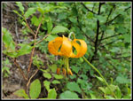 Tiger Lily |
 Tall Penstemon |
 Lakes From Viewpoint |
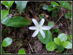 Queen's Cup |
 Lupine |
 Trail Steepens |
 White Flower |
 Yellow Flowers |
 Ridge Flattens |
 More Lupine |
 Baldy In The Clouds |
 Columbia Lewisia |
 Lots Of Phlox |
 Lush Forest |
 Purple Flower |
 Columbine |
 Lake Cle Elum |
 Colorful Penstemon |
 Cloudy Ridge |
 Balsamroot Close Up |
 Indian Paintbrush & Phlox |
 Baldy Summit |
 Mess Of Phlox |
 Hikers On Summit |
 Phlox Close Up |
 Balsamroot Patches |
 Lots Of Color |
 More Color On Ridge |
 Beargrass |
 Rare Sight |
 Down From Para Point |
 Back At Viewpoint |
 Trail Junction |
 Another Tiger Lily |
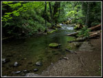 Silver Creek |
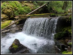 Back At Waterfall |
Trips - 2020
Home