3-21-20
The
coronavirus had much of Seattle
closed down. After a week in the house I was ready for a long hike. We
had gotten out on Wednesday for a lonesome evening hike on Tiger
Mountain. Other than one trip to the grocery store that was the only
time all week I left my house. Gary was in for a trip too. We kicked
around ideas Friday night. We both did not want to hike a busy trail.
Since we would be traveling alone we did not want a long drive for
multiple cars. I leaned towards a road walk where we would see few
folks and could pass easily while staying well away from each other.
The virus transmits through the air so we needed the space. Lastly, I
was afraid that a total lockdown might occur before the virus reached
its peak. With no hiking a possibility in the near future I wanted to
get in a long hike. To top it off Saturday was looking to be sunny and
near 60 degrees. That is warm this time of year.
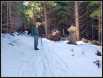
We settled on Rattlesnake Mountain from Highway 18. A few weeks ago I went to Grand Prospect and on to near the summit of West Rattlesnake in 8.5 miles round trip. This trip would be about 17 miles round trip. Folks don't like boring road walks. I seldom see people until near the summit. John signed on to the trip also. Early Saturday morning Gary called to say he had a bit of a cough. Much more likely it was something minor but he did not want to be coughing around us just in case it might be the coronavirus. John met me just off Highway 15 near I-90 at 7:55 am. I was five minutes early and he was even earlier. During the virus pandemic the road around Seattle have been mostly open. My drive home in the afternoon had no slowdowns at all. No traffic and we arrived early. There was one vehicle already there. We never saw that person.
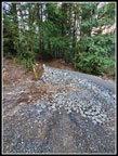
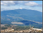
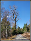
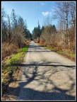
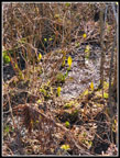
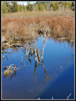
The route starts out on pavement as it crosses a big wetland. For only the second time ever the first gate was open. We hiked across the wetland seeing a few bright yellow skunk cabbage. At 1 mile we reached the power sub station. The gate there was locked as always. Nice views out to Tiger Mountain. There are mile markers every half mile up to six miles. The next 1.5 miles is flat and straight. At Canyon Creek the route turns left and follows the creek to the bridge. I did not venture here for the half dozen or more years the old culvert was washed out. The new bridge is five or six years old. Now comes the fun part. The road begins to climb. This is among the steeper section of the day. Straight up we went. There is a new bike trail that goes just off the trail on one side and crosses the road twice. Slowly new trails are providing non road options to this side of Rattlesnake Mountain. The trails are not yet open though it looks like some folks have tried them out.
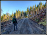
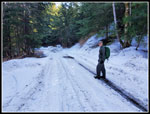
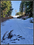
At the top of the climb there is a junction. We stayed right on the main road. Now is more easy walking as the grade is gentle for the next 1.5 miles. We kept looking for any early wildflowers but saw none on the way up. At 4.5 miles we took a break. Here we took a sharp left at an open gated road. It starts with a quick climb. We took only 1:19 to this point for an average speed of 3.5 mph. That is well above my average. We were just pat the half way mark to the summit. After the junction at 4.5 miles the road switches back right at 5.0 miles and switches back again at 5.5 miles. It is strange as these turns area all at half mile marks. At just before 6.5 mile we reached the next junction. We turned right and almost immediately the snow began. The road was part bare and partly covered with icy snow. Trucks had been up it so the snow was not deep but packed and frozen. Poles came in handy though were not necessary.
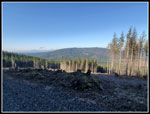
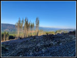
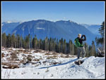
The next junction is where the new bike trail from Stan's Overlook crosses the road. We took a short break here. A couple minutes later four young women came running down the road. They had been to Grand Prospect and to the summit of West Rattlesnake. If we had left a minute earlier we would not have seen them. They headed down the trail. We headed up the trail. Bare at first it soon was completely snow covered. There were no fresh tracks. We were the first folks up this day. The trail crossed the road once then again right below the summit. We crossed the road and the trail quickly reaches the clear cut. At the clear cut border we left forest and went into the sunshine. It was not cloudless but there was a lot of sun. It was 45 degrees but felt much warmer. We had hiked up 8.1 miles in 2:46, arriving at 10:42 am. With just a windshirt I was plenty warm enough.
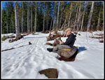
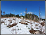
We were in no hurry to leave. Our lunch lasted until 11:54 am. We finally started moving. There was enough snow to cover the ground and small logs. It was still pretty hard. We headed straight uphill towards the summit. Near the top our views from south to northeast widened. We now could see Mt. Si and peaks farther north. John heard voices and we spotted two hikers on the road in the clear cut to the east. We saw two hikers in one direction and one going in the other. Though they were half a mile away we could gear them talking. From the summit we dropped down to the lower towers. We went into the shade over the top and it was cold. Back in the sunshine it was warm. We enjoyed a little last sunshine before heading back to the summit. Now it was time to head down. We left the summit at 12:13 pm.
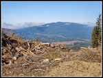
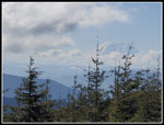
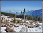
Down the road to pick up the trail again. There were two logs down right before the trail reached the road. Folks have been climbing up the bank to the road. We moved one smaller tree off the trail. John then cut the branches off the other. It is not hard to get over or around it now. On the trail section we met two bikers pushing their bikes uphill in the snow. Lower down we met one more biker. That brought the total to 7 other people. Back on the road the ice had softened. Walking was much easier. It did not take long to reach the first junction and the end of the snow. The upper road has a number of recent clear cuts which provide good views from southwest to northwest. Tiger Mountain was clear all day. In the morning any farther views were cloudy and hazy. On the way down they still were.
The miles went by pretty fast. Down to the 4.5 mile junction for a short break then on we went. Near the top of the big hill we took the other road and followed it over to the upper Canyon Creek Bridge. Coming back we explored the new trail that drops down the road in the middle of the big hill. We saw one more biker. After crossing the lower bridge we were on the long straight section back to the power sub station. Two hikers went by going in. Back by the power station they ran by us heading out. That brought us up to 10 people seen all day long. The last mile was a bit painful for my feet. On the way down we saw quite a few patches of coltsfoot in bloom. None on the way up. They must have all opened in late morning. Back at the wetland we noticed even more skunk cabbage in bloom.
We made it back to the cars at 3:15 pm. That was 3:02 coming down. Considering that we took the detour to the upper Canyon Creek Bridge our moving time was similar to our uphill time. Our average moving speed was 3.0 mph which is very good for me over 17 miles. In total we saw those 10 people all day long. If we had not taken a break we would have missed the four women runners. The next day I saw a photo of Rattlesnake Ledge at the other end of the mountain and over 120 people were at the ledge at the time the drone took the picture. That is not safe social distancing. We had a 20' wide road to ourselves nearly the entire day. Much safer. This is not my favorite springtime hike but under the unusual circumstances we made the most of it. For the day the stats were 17 miles hiked with 2500' of elevation gain. John and I had a great time.
Click on thumbnails to get
larger pictures.
Trips - 2020
Home
We settled on Rattlesnake Mountain from Highway 18. A few weeks ago I went to Grand Prospect and on to near the summit of West Rattlesnake in 8.5 miles round trip. This trip would be about 17 miles round trip. Folks don't like boring road walks. I seldom see people until near the summit. John signed on to the trip also. Early Saturday morning Gary called to say he had a bit of a cough. Much more likely it was something minor but he did not want to be coughing around us just in case it might be the coronavirus. John met me just off Highway 15 near I-90 at 7:55 am. I was five minutes early and he was even earlier. During the virus pandemic the road around Seattle have been mostly open. My drive home in the afternoon had no slowdowns at all. No traffic and we arrived early. There was one vehicle already there. We never saw that person.
The route starts out on pavement as it crosses a big wetland. For only the second time ever the first gate was open. We hiked across the wetland seeing a few bright yellow skunk cabbage. At 1 mile we reached the power sub station. The gate there was locked as always. Nice views out to Tiger Mountain. There are mile markers every half mile up to six miles. The next 1.5 miles is flat and straight. At Canyon Creek the route turns left and follows the creek to the bridge. I did not venture here for the half dozen or more years the old culvert was washed out. The new bridge is five or six years old. Now comes the fun part. The road begins to climb. This is among the steeper section of the day. Straight up we went. There is a new bike trail that goes just off the trail on one side and crosses the road twice. Slowly new trails are providing non road options to this side of Rattlesnake Mountain. The trails are not yet open though it looks like some folks have tried them out.
At the top of the climb there is a junction. We stayed right on the main road. Now is more easy walking as the grade is gentle for the next 1.5 miles. We kept looking for any early wildflowers but saw none on the way up. At 4.5 miles we took a break. Here we took a sharp left at an open gated road. It starts with a quick climb. We took only 1:19 to this point for an average speed of 3.5 mph. That is well above my average. We were just pat the half way mark to the summit. After the junction at 4.5 miles the road switches back right at 5.0 miles and switches back again at 5.5 miles. It is strange as these turns area all at half mile marks. At just before 6.5 mile we reached the next junction. We turned right and almost immediately the snow began. The road was part bare and partly covered with icy snow. Trucks had been up it so the snow was not deep but packed and frozen. Poles came in handy though were not necessary.
The next junction is where the new bike trail from Stan's Overlook crosses the road. We took a short break here. A couple minutes later four young women came running down the road. They had been to Grand Prospect and to the summit of West Rattlesnake. If we had left a minute earlier we would not have seen them. They headed down the trail. We headed up the trail. Bare at first it soon was completely snow covered. There were no fresh tracks. We were the first folks up this day. The trail crossed the road once then again right below the summit. We crossed the road and the trail quickly reaches the clear cut. At the clear cut border we left forest and went into the sunshine. It was not cloudless but there was a lot of sun. It was 45 degrees but felt much warmer. We had hiked up 8.1 miles in 2:46, arriving at 10:42 am. With just a windshirt I was plenty warm enough.
We were in no hurry to leave. Our lunch lasted until 11:54 am. We finally started moving. There was enough snow to cover the ground and small logs. It was still pretty hard. We headed straight uphill towards the summit. Near the top our views from south to northeast widened. We now could see Mt. Si and peaks farther north. John heard voices and we spotted two hikers on the road in the clear cut to the east. We saw two hikers in one direction and one going in the other. Though they were half a mile away we could gear them talking. From the summit we dropped down to the lower towers. We went into the shade over the top and it was cold. Back in the sunshine it was warm. We enjoyed a little last sunshine before heading back to the summit. Now it was time to head down. We left the summit at 12:13 pm.
Down the road to pick up the trail again. There were two logs down right before the trail reached the road. Folks have been climbing up the bank to the road. We moved one smaller tree off the trail. John then cut the branches off the other. It is not hard to get over or around it now. On the trail section we met two bikers pushing their bikes uphill in the snow. Lower down we met one more biker. That brought the total to 7 other people. Back on the road the ice had softened. Walking was much easier. It did not take long to reach the first junction and the end of the snow. The upper road has a number of recent clear cuts which provide good views from southwest to northwest. Tiger Mountain was clear all day. In the morning any farther views were cloudy and hazy. On the way down they still were.
The miles went by pretty fast. Down to the 4.5 mile junction for a short break then on we went. Near the top of the big hill we took the other road and followed it over to the upper Canyon Creek Bridge. Coming back we explored the new trail that drops down the road in the middle of the big hill. We saw one more biker. After crossing the lower bridge we were on the long straight section back to the power sub station. Two hikers went by going in. Back by the power station they ran by us heading out. That brought us up to 10 people seen all day long. The last mile was a bit painful for my feet. On the way down we saw quite a few patches of coltsfoot in bloom. None on the way up. They must have all opened in late morning. Back at the wetland we noticed even more skunk cabbage in bloom.
We made it back to the cars at 3:15 pm. That was 3:02 coming down. Considering that we took the detour to the upper Canyon Creek Bridge our moving time was similar to our uphill time. Our average moving speed was 3.0 mph which is very good for me over 17 miles. In total we saw those 10 people all day long. If we had not taken a break we would have missed the four women runners. The next day I saw a photo of Rattlesnake Ledge at the other end of the mountain and over 120 people were at the ledge at the time the drone took the picture. That is not safe social distancing. We had a 20' wide road to ourselves nearly the entire day. Much safer. This is not my favorite springtime hike but under the unusual circumstances we made the most of it. For the day the stats were 17 miles hiked with 2500' of elevation gain. John and I had a great time.
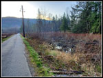 Heading Out |
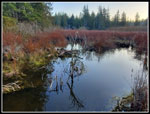 Reflection |
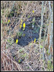 Skunk Cabbage |
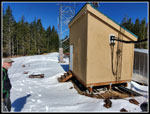
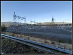 Power Sub Station |
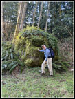 Jim & Erratic |
 New Trail |
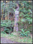 4.5 Mile Marker |
 Entering Clear Cut |
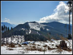
 Tiger Mountain View |
 View To Northwest |
 Distant Highway 18 |
 Onto Icy Snow |
 Stump Rocks |
 Road Below Summit |
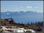 Snowy Peaks |
 Mt. Rainier |
 Lunch Spot |
 John At Work |
 View To The North |
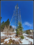
 Rattlesnake Towers |
 Actual Summit |
 Ridge & East Summit |
 Towers & Blue Sky |
 Heading Down |
 More Clouds |
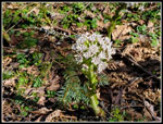 Coltsfoot |
 Another Trail |
 Me & My Shadow |
 Big Tree |
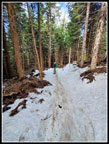
 Last Straightaway |
 More Skunk Cabbage |
 Nice Reflection |
Trips - 2020
Home