9/24-25/21
Day 1
I had not been out on a backpacking trip in two years. This year was slipping away. With a sunny Friday and Saturday coming but rain on Sunday, I asked Gary to join me on a trip. He had been back east for a week but found the time to go. We met at my house at 6:50 am and headed for Highway 2. I joined Bob and Kolleen for a backpacking trip to Benchmark Mountain in 2010. We camped on the summit and there was still some snow there to melt for water. My tent was staked in sand and high winds collapsed it during the night. We planned to camp on top too. The road over Jack's Pass and on to the trailhead was in fine shape. Some pot holes but not bad. We arrived at about 9:00 am. There were more than half a dozen cars in the lot. They had wet windshields so they were there overnight. The lot serves the Quartz Creek, NF Skykomish, and West Cady trails. Most were likely to not be on the West Cady route.
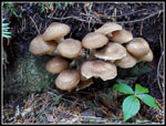
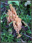
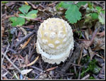
The sky was clear and it was in the low 50s. Excellent conditions. The trail parallels the NF Skykomish River then crosses on a high bridge. The next two miles are in deep forest. Some big trees and a whole lot of fresh mushrooms. The last few weeks after some hard rain has really brought out the mushrooms. We had a number of photo stops here. For this trip it was not clear that we would have water on the summit. I brought 3 full quarts of water. Usually, we can bring a quart and pump more as necessary. More weight meant less interest in kneeling down for photos.
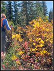
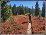
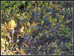
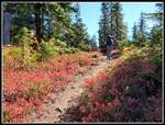
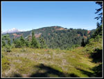
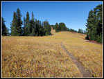
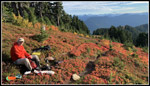
We made our way up the nicely graded trail. One guy with a day pack zoomed in by us heading up. Then we met a couple coming down after a loop trip. they spent the night before on the summit. Yes, the two tarns below the summit had plenty of clear water. The wind blew hard in the middle of the night and their exposed tent site was not much fun. We reconsidered camping at another spot on the ridge below the summit. They mentioned a solo hiker took that spot last night. We saw the solo guy. His pack was tiny. We were amazed he had food and shelter from the wind. The trail breaks out of the forest at about the 2 mile point. The huckleberry bushes began at once. They never really ended. A few early berries were a little tart. Soon they were very sweet. No need to leave the trail as the bushes were loaded and right along the side of the trail. We ate well and left a whole lot for the wildlife.
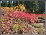
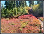
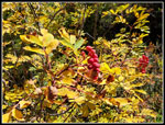
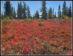
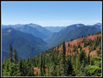
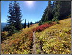
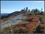
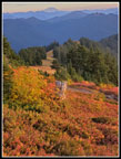
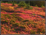
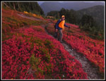
The colors also started at once as we left the forest. Huckleberry and mountain ash were very colorful. Bright red for the ash and red and orange for the huckleberry. The photo opportunities were continuous. We stopped for lunch at a spot just off the trail. We had a view of Glacier Peak. The beauty of a 6.8 mile hike is that we had lots of time for photos, berry eating, and just sitting and enjoying the views. We were soon back on our way. The ridge top is a gentle climb with some ups and downs. When it began to get warm in the sunshine there is another short forested part. Just about perfect.
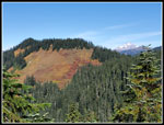
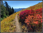
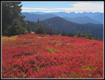
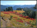
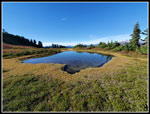
At times we had great views back to Columbia and Kyes Peaks. Glacier Peak would appear for a moment. Sloan Peak made a few appearances too. Some of the berries in the sunniest spots were past prime. Many more in some shade were still very sweet. One final and longer climb brought us to a point that is the border of the Wild Sky Wilderness and the Henry Jackson Wilderness. This was the next to last day of the high hunt in the Henry Jackson Wilderness. We brought orange vests and hats for that reason. There was a very small chance we would see any hunters but better safe than sorry. We did not see or hear any hunting. There is a sign at the border but none naming either wilderness. There is a dry campsite at the high point. We dropped down in forest to a meadow to a tarn. It did have decent water. Farther down in a meadow is another small tarn. It too was nearly full. After a very hot dry summer we were surprised to see the recent hard rain had recharged the tarns.
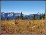
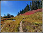
The route drops a little more in open colorful meadows. Some bright red, orange, and yellow and also some golden grasses. All of it was really pretty. The final climb to the summit is very meadow-like. We kept stopping for photos. Turning around provided sun lit brightly colored leaves. The wind was blowing a bit and we began to debate camping on the summit or down on the ridge. The main trail contours around Benchmark and heads over to the Pacific Crest Trail (PCT). Another trail heads right up the ridge to the top. When we were near the junction we spotted the campsite right off the trail. It is very forested with some wind protection. It is a horse camp too. One end is a bit horsey. The other end is better. It was plenty large for our two tents. I'm sure my memory of sleeping in a collapsed tent had something to do with my thoughts. We decided to camp on the ridge.
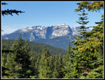
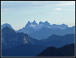
We arrived at our 5525' camp at 2:50 pm. We set up camp and took a break. Great views of Sloan Peak from camp. We packed up food and headed up to the summit. It is only about 250' of elevation gain to the top. The wind was blowing harder as we hiked up. Part way up the trail left the bare ridge and went left tot he west side. The wind was dead calm here. We noted it as the best spot to cook dinner later. This part of the route had some spectacular red leaf color too. We arrived at the summit at 3:53 pm.It was still clear though we could now see clouds to the west coming in. Great views in all directions. Mt. Rainier to the south but also Chimney Rock, Daniel and Hinman, and Mt. Stuart. The Wild Sky peaks are to the southwest. West is the Monte Cristo Peaks including, Columbia, Kyes, and Monte Cristo Peak. Farther north is Sloan plus parts of Pugh and White Chuck then Glacier Peak. Three Fingers and Whitehorse were just visible. We were able to find Johnson Mountain and others. To the northeast it was harder to recognize peaks from this angle. It really is a great spot to look at all the mountains.
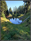
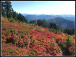
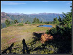
We spent time enjoying the views and photographing them. Down below we could see red and orange meadows all around. We then headed north on the ridge to the campsites. They are exposed to the weather. Especially the wind. One is a small pit that blocks wind at the bottom of a tent but would fill with water when it rains. The other is the sandy spot I camped at in 2010. With the wind still building we were happy to have camp set up just below the summit. Below the summit campsites, we could see the two tarns set in a big colorful meadow. We found a fairly easy way down from the ridge. A couple hundred vertical feet later we were at the larger tarn. The water level was plenty high to fill our water bag. It was surprisingly clear water. Someone built a fire ring at the edge of the tarn when the level was lower. Now it was partly submerged. The wind was minimal down here so we decided to take another break.
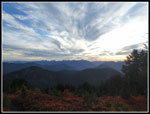
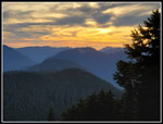
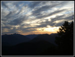
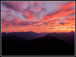
We arrived at the tarn at 4:22 pm. We sat around for a while then filled the water bag with enough for dinner and breakfast. We finally headed back uphill at 5:06 pm. Back on the summit ridge, the wind was blowing much harder. I had my jacket hood on to keep my hat from flying away. We stopped at the summit for a few more photos then headed down. We were immediately out of the wind. At a good viewpoint amidst a sea of colorful leaves, we stopped for dinner. Sitting on the trail we boiled water for dinner. Bugs were not much of a problem so we decided to wait here for sunset at 6:54 pm. We had a great view to the west plus northwest and south. The setting sun was great with the remaining blue sky and the white clouds. Once the sun dropped out of sight the best show began. Sunlight lit up the undersides of the clouds. That was really amazing. The lighting changed by the seconds.
When that was done we packed up and headed down to camp. We had some wind in camp but the noise in the treetops made it clear it was blowing pretty hard. I woke up at 10:45 pm and the wind was gone. I slept pretty well. Much better than usual for the first night out of the year. We went to bed at 8:00 pm well after it was completely dark. Daylight would return in a long eleven hours. The first day of our trip was a complete success. We saw only four people but a million colorful leaves and many ripe huckleberries.
Click on thumbnails to get
larger pictures.
Day 2
Trips - 2021
Home
I had not been out on a backpacking trip in two years. This year was slipping away. With a sunny Friday and Saturday coming but rain on Sunday, I asked Gary to join me on a trip. He had been back east for a week but found the time to go. We met at my house at 6:50 am and headed for Highway 2. I joined Bob and Kolleen for a backpacking trip to Benchmark Mountain in 2010. We camped on the summit and there was still some snow there to melt for water. My tent was staked in sand and high winds collapsed it during the night. We planned to camp on top too. The road over Jack's Pass and on to the trailhead was in fine shape. Some pot holes but not bad. We arrived at about 9:00 am. There were more than half a dozen cars in the lot. They had wet windshields so they were there overnight. The lot serves the Quartz Creek, NF Skykomish, and West Cady trails. Most were likely to not be on the West Cady route.
The sky was clear and it was in the low 50s. Excellent conditions. The trail parallels the NF Skykomish River then crosses on a high bridge. The next two miles are in deep forest. Some big trees and a whole lot of fresh mushrooms. The last few weeks after some hard rain has really brought out the mushrooms. We had a number of photo stops here. For this trip it was not clear that we would have water on the summit. I brought 3 full quarts of water. Usually, we can bring a quart and pump more as necessary. More weight meant less interest in kneeling down for photos.
We made our way up the nicely graded trail. One guy with a day pack zoomed in by us heading up. Then we met a couple coming down after a loop trip. they spent the night before on the summit. Yes, the two tarns below the summit had plenty of clear water. The wind blew hard in the middle of the night and their exposed tent site was not much fun. We reconsidered camping at another spot on the ridge below the summit. They mentioned a solo hiker took that spot last night. We saw the solo guy. His pack was tiny. We were amazed he had food and shelter from the wind. The trail breaks out of the forest at about the 2 mile point. The huckleberry bushes began at once. They never really ended. A few early berries were a little tart. Soon they were very sweet. No need to leave the trail as the bushes were loaded and right along the side of the trail. We ate well and left a whole lot for the wildlife.
The colors also started at once as we left the forest. Huckleberry and mountain ash were very colorful. Bright red for the ash and red and orange for the huckleberry. The photo opportunities were continuous. We stopped for lunch at a spot just off the trail. We had a view of Glacier Peak. The beauty of a 6.8 mile hike is that we had lots of time for photos, berry eating, and just sitting and enjoying the views. We were soon back on our way. The ridge top is a gentle climb with some ups and downs. When it began to get warm in the sunshine there is another short forested part. Just about perfect.
At times we had great views back to Columbia and Kyes Peaks. Glacier Peak would appear for a moment. Sloan Peak made a few appearances too. Some of the berries in the sunniest spots were past prime. Many more in some shade were still very sweet. One final and longer climb brought us to a point that is the border of the Wild Sky Wilderness and the Henry Jackson Wilderness. This was the next to last day of the high hunt in the Henry Jackson Wilderness. We brought orange vests and hats for that reason. There was a very small chance we would see any hunters but better safe than sorry. We did not see or hear any hunting. There is a sign at the border but none naming either wilderness. There is a dry campsite at the high point. We dropped down in forest to a meadow to a tarn. It did have decent water. Farther down in a meadow is another small tarn. It too was nearly full. After a very hot dry summer we were surprised to see the recent hard rain had recharged the tarns.
The route drops a little more in open colorful meadows. Some bright red, orange, and yellow and also some golden grasses. All of it was really pretty. The final climb to the summit is very meadow-like. We kept stopping for photos. Turning around provided sun lit brightly colored leaves. The wind was blowing a bit and we began to debate camping on the summit or down on the ridge. The main trail contours around Benchmark and heads over to the Pacific Crest Trail (PCT). Another trail heads right up the ridge to the top. When we were near the junction we spotted the campsite right off the trail. It is very forested with some wind protection. It is a horse camp too. One end is a bit horsey. The other end is better. It was plenty large for our two tents. I'm sure my memory of sleeping in a collapsed tent had something to do with my thoughts. We decided to camp on the ridge.
We arrived at our 5525' camp at 2:50 pm. We set up camp and took a break. Great views of Sloan Peak from camp. We packed up food and headed up to the summit. It is only about 250' of elevation gain to the top. The wind was blowing harder as we hiked up. Part way up the trail left the bare ridge and went left tot he west side. The wind was dead calm here. We noted it as the best spot to cook dinner later. This part of the route had some spectacular red leaf color too. We arrived at the summit at 3:53 pm.It was still clear though we could now see clouds to the west coming in. Great views in all directions. Mt. Rainier to the south but also Chimney Rock, Daniel and Hinman, and Mt. Stuart. The Wild Sky peaks are to the southwest. West is the Monte Cristo Peaks including, Columbia, Kyes, and Monte Cristo Peak. Farther north is Sloan plus parts of Pugh and White Chuck then Glacier Peak. Three Fingers and Whitehorse were just visible. We were able to find Johnson Mountain and others. To the northeast it was harder to recognize peaks from this angle. It really is a great spot to look at all the mountains.
We spent time enjoying the views and photographing them. Down below we could see red and orange meadows all around. We then headed north on the ridge to the campsites. They are exposed to the weather. Especially the wind. One is a small pit that blocks wind at the bottom of a tent but would fill with water when it rains. The other is the sandy spot I camped at in 2010. With the wind still building we were happy to have camp set up just below the summit. Below the summit campsites, we could see the two tarns set in a big colorful meadow. We found a fairly easy way down from the ridge. A couple hundred vertical feet later we were at the larger tarn. The water level was plenty high to fill our water bag. It was surprisingly clear water. Someone built a fire ring at the edge of the tarn when the level was lower. Now it was partly submerged. The wind was minimal down here so we decided to take another break.
We arrived at the tarn at 4:22 pm. We sat around for a while then filled the water bag with enough for dinner and breakfast. We finally headed back uphill at 5:06 pm. Back on the summit ridge, the wind was blowing much harder. I had my jacket hood on to keep my hat from flying away. We stopped at the summit for a few more photos then headed down. We were immediately out of the wind. At a good viewpoint amidst a sea of colorful leaves, we stopped for dinner. Sitting on the trail we boiled water for dinner. Bugs were not much of a problem so we decided to wait here for sunset at 6:54 pm. We had a great view to the west plus northwest and south. The setting sun was great with the remaining blue sky and the white clouds. Once the sun dropped out of sight the best show began. Sunlight lit up the undersides of the clouds. That was really amazing. The lighting changed by the seconds.
When that was done we packed up and headed down to camp. We had some wind in camp but the noise in the treetops made it clear it was blowing pretty hard. I woke up at 10:45 pm and the wind was gone. I slept pretty well. Much better than usual for the first night out of the year. We went to bed at 8:00 pm well after it was completely dark. Daylight would return in a long eleven hours. The first day of our trip was a complete success. We saw only four people but a million colorful leaves and many ripe huckleberries.
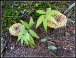 First Mushrooms |
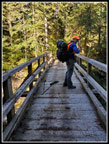 Gary On The Bridge |
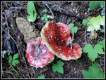 Colorful Mushrooms |
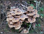 Mess Of Mushrooms |
 More Mushrooms |
 Fungus |
 Out Of The Forest |
 Lit Up Leaves |
 Colorful Meadow |
 Ascending Meadow |
 Glacier Peak In Sight |
 Sloan Peak |
 More Great Colors |
 Another Mushroom |
 Mountain Ash |
 Wall To Wall Red |
 Gary Crosses Meadow |
 Huckleberries! |
 Lined With Color |
 Unlit Meadow |
 WF Cady Creek |
 Monte Cristo Peaks |
 Golden Grass |
 First Tarn |
 Benchmark In Sight |
 Second Tarn |
 Looking Back To Colors |
 Really Bright |
 Golden Meadow Ahead |
 Sweet! |
 Colorful W Cady Ridge |
 Heading For Summit |
 Summit Campsite |
 Nearing Tarn |
 Tarn Below Summit |
 Dinner & Sunset Spot |
 Overcoat Peak |
 White Sky |
 Setting Sun |
 Almost Gone |
 Soft Lighting |
 Beautiful Colors |
 Gary At Sunset |
 Fantastic Sunset |
Day 2
Trips - 2021
Home