12-05-21
November
was among the wettest months on record. Early snow all melted. Mid-week
we managed to get in an after work headlamp umbrella hike. No snow
until
right at Grand Prospect (3100'). There was just a little there.
Saturday was rain all day and snow in the mountains. On Sunday I was
ready to get out in the snow but without too much deep fresh snow. I
also wanted to avoid crowds on the popular trails. I chose another trip
to East Tiger Mountain. The trailhead is near 1400' and the summit is
at 3000'. I have done a lot of trip to East Tiger during the pandemic
as the wide road is safe and the trails up are not crowded in the early
morning. This day the morning was sub freezing and I did not get on the
road until. 7:40 am. I arrived at the inner Tiger Summit Trailhead at
8:20 am. Almost no snow there. Only about a dozen or less cars in the
lot. I was on my way by 8:25 am. There were no people at the parking
lot. There were no people on the trail. I saw nobody all the way up
East Tiger.
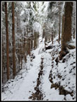
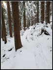
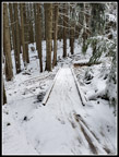
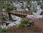
It was 30 degrees at the start. The bridge on the Connector Trail had snow and ice on it. The trail in forest was bare. I followed the Connector Trail to the main road and crossed it onto the NW Timber Trail. A short way along I turned off left uphill on the Master Link. Since this is bikes only uphill but hikers in both directions I do not have to worry about speeding bikes coming down. Some bikers are early but most seem to arrive later than me. That gives me a chance to get well up the trail before seeing anyone. This day it worked perfectly. As I climbed I began to see fresh snow. First on the brush and soon after on the trail. Bikes had been going up it yesterday in the snow. The tracks were very clear. I usually do not post a report with photos for East Tiger Mountain. With the fresh snow it was really very beautiful. I took quite a few photos on the way up. By the time I reached the big bridge the snow was an inch or two deep. Not enough to slow me down much but enough to cover the trail.
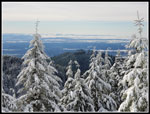
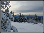
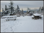
As I neared the upper road I kept expecting some bikers to pass me. It did not happen. The road it self had 3 or more inches of snow. I crossed and continued on the Quick Link Trail. I was making good but not great time. I had plenty of time before dark so fast was not necessary. The Quick Link deposited me back on the main upper road. There were a few bike tracks and a few walker tracks. No trench was yet in place. The trees along the road were really snow plastered. A short climb brought me to the high point and then a short drop down to the junction below the summit. I went right on the summit spur road. The snow was still only 3-4 inches deep. I passed the open gate and went left to the viewpoint. Lots of snow on the picnic tables. There was a clear view of Mt. Rainier. Largely cloudy overhead but great views out including the summit of Rainier. I headed back to the road. I almost always walk up the road to the summit. There is a new bike trail that is one way only uphill. Near the top it is a narrow cut in a very steep hillside and there is barely room for a bike and hiker to get by each other. That is why I avoid it usually. I was feeling lucky and hoped I could hike up it without a bike catching up with me.
I reached the top with no bikes in sight. It is unusual to be on top on a dry day without anyone else. Bikers are coming and going constantly. Not this morning. I arrived on top at 10:21 am. Nearly two hours is a very slow time for me. Considering I had my winter weight pack and high top boots and the snow and many photos it was not all that bad. I had almost as good a view of Mt. Rainier as I had at the lower viewpoint. In places below fog sat in valleys. In most places it was clear. I had a little blue sky coming up but it was mostly cloudy now. A little food, water, and photos and I packed up and started down at 10:36 am. That was my only break the whole day. By now I had decided to go down the Off The Grid Trail (OTG). It would be about a 10 miles loop on less traveled trails. That distance might get painful on a foot suffering from plantar fasciitis but it was too nice a day for a short trip.
I was thinking how lucky I had been to hike over 4 miles and not see a single person when I saw a lone biker at the junction with the OTG Trail. There were three of his friends also coming up. I did not see them. The road had no recent bike tracks so they had been slogging up in abut 4" of fluffy snow. I turned off on the East Tiger Trail and in a few minutes left that for the OTG. The trail has a number of short jumps that require the hiker to jump or carefully climb down a few steep feet. With the snow it was more challenging. I managed to slip and slide and remain vertical the whole time. Where the OTG is right below the Quick Link Trail I stopped. I looked at the map and saw I would get a little more elevation and distance by heading to the QL. I would also exchange the many short jumps on the OTG for a smooth trail then a smooth road to get down to the end of the OTG. The cross country part was easy and I was on the QL very quickly. What I found was not part of the plan. In 7 minutes on the QL I passed 11 bikers and 1 hiker. The crowds had arrived.
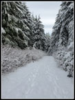
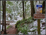
I was glad to reach the upper road. I left the crowds and headed down the snow covered road. One biker had tried to ride down in the snow with mixed results. Every few dozen feet the track stopped and footprints appeared. The biker kept stopping. I had no such problem. The road had enough snow to cushion my steps but it was not slick. Much better than walking the dirt and gravel road. The road has big evergreen trees along both sides and some smaller deciduous trees with fare limbs. Everything was covered in fresh snow. It was about as good at Tiger Mountain can look. I took a number of photos and short videos along here. Farther down I was very surprised to see two bikers slogging up the steep road in the snow. They were barely going fast enough to stay upright but doggedly determined to keep heading up. Now I was up to 15 people seen. Where the OTG reached the road I turned right on the Joy Ride Trail. This trail has a few OTG like jumps and some very smooth tread. It is narrower than most of the trails. As I continued to descend in forest the snow began to thin. In its place was bare ground and quite a few small to medium sized mud puddles. I had on my high top waterproof boots so it was not a problem.
I seldom see more than a few folks on this trail. It is the last mile or so of the NW Timber trail where I start to see folks. This day the lower Joy Ride had half a dozen groups passing by me. I was glad to reach the NW Timber Trail. A gentle uphill then flat back to the trailhead. At the 7 mile mark on this trip I reached my goal for a very good hiking year. I reached 800 miles on the trail. My other goal is 200,000' of elevation gain. I reached that on the way up East Tiger in the morning. I don't recall reaching both goals on the same hike.
I as running out of gas when I reached the Connector Trail. Just .30 miles to go. Looking at my gps I realized that I needed another .6 miles to reach 11 for the day. Though My sore heel was not excited my brain took over and I headed .30 miles up the Iverson Railroad Trail to round out my day. I finally reached my car at 1:40 pm. The lot was nearly full now. Though the traffic map on my phone showed bad traffic in downtown Seattle my drive home was smooth and fast.
This was a great hike. It was cold but not frigid. There was no wind all day long. I hiked over 4 miles before seeing a single person. If I had not detoured to the QL coming back I likely would have seen 14 people instead of 26. Still, 26 people over 5 hours is not crowded. That is five minutes on the Mt. Si Trail. The snow was deep enough to really cover everything but not to impede my hiking. I brought microspikes but never needed them. Great conditions and a really beautiful hike on Tiger Mountain. All that, and I reached both my mileage and elevation goals for the year. A really fun day on the trail.
Click on thumbnails to get
larger pictures.
Trips - 2021
Home
It was 30 degrees at the start. The bridge on the Connector Trail had snow and ice on it. The trail in forest was bare. I followed the Connector Trail to the main road and crossed it onto the NW Timber Trail. A short way along I turned off left uphill on the Master Link. Since this is bikes only uphill but hikers in both directions I do not have to worry about speeding bikes coming down. Some bikers are early but most seem to arrive later than me. That gives me a chance to get well up the trail before seeing anyone. This day it worked perfectly. As I climbed I began to see fresh snow. First on the brush and soon after on the trail. Bikes had been going up it yesterday in the snow. The tracks were very clear. I usually do not post a report with photos for East Tiger Mountain. With the fresh snow it was really very beautiful. I took quite a few photos on the way up. By the time I reached the big bridge the snow was an inch or two deep. Not enough to slow me down much but enough to cover the trail.
As I neared the upper road I kept expecting some bikers to pass me. It did not happen. The road it self had 3 or more inches of snow. I crossed and continued on the Quick Link Trail. I was making good but not great time. I had plenty of time before dark so fast was not necessary. The Quick Link deposited me back on the main upper road. There were a few bike tracks and a few walker tracks. No trench was yet in place. The trees along the road were really snow plastered. A short climb brought me to the high point and then a short drop down to the junction below the summit. I went right on the summit spur road. The snow was still only 3-4 inches deep. I passed the open gate and went left to the viewpoint. Lots of snow on the picnic tables. There was a clear view of Mt. Rainier. Largely cloudy overhead but great views out including the summit of Rainier. I headed back to the road. I almost always walk up the road to the summit. There is a new bike trail that is one way only uphill. Near the top it is a narrow cut in a very steep hillside and there is barely room for a bike and hiker to get by each other. That is why I avoid it usually. I was feeling lucky and hoped I could hike up it without a bike catching up with me.
I reached the top with no bikes in sight. It is unusual to be on top on a dry day without anyone else. Bikers are coming and going constantly. Not this morning. I arrived on top at 10:21 am. Nearly two hours is a very slow time for me. Considering I had my winter weight pack and high top boots and the snow and many photos it was not all that bad. I had almost as good a view of Mt. Rainier as I had at the lower viewpoint. In places below fog sat in valleys. In most places it was clear. I had a little blue sky coming up but it was mostly cloudy now. A little food, water, and photos and I packed up and started down at 10:36 am. That was my only break the whole day. By now I had decided to go down the Off The Grid Trail (OTG). It would be about a 10 miles loop on less traveled trails. That distance might get painful on a foot suffering from plantar fasciitis but it was too nice a day for a short trip.
I was thinking how lucky I had been to hike over 4 miles and not see a single person when I saw a lone biker at the junction with the OTG Trail. There were three of his friends also coming up. I did not see them. The road had no recent bike tracks so they had been slogging up in abut 4" of fluffy snow. I turned off on the East Tiger Trail and in a few minutes left that for the OTG. The trail has a number of short jumps that require the hiker to jump or carefully climb down a few steep feet. With the snow it was more challenging. I managed to slip and slide and remain vertical the whole time. Where the OTG is right below the Quick Link Trail I stopped. I looked at the map and saw I would get a little more elevation and distance by heading to the QL. I would also exchange the many short jumps on the OTG for a smooth trail then a smooth road to get down to the end of the OTG. The cross country part was easy and I was on the QL very quickly. What I found was not part of the plan. In 7 minutes on the QL I passed 11 bikers and 1 hiker. The crowds had arrived.
I was glad to reach the upper road. I left the crowds and headed down the snow covered road. One biker had tried to ride down in the snow with mixed results. Every few dozen feet the track stopped and footprints appeared. The biker kept stopping. I had no such problem. The road had enough snow to cushion my steps but it was not slick. Much better than walking the dirt and gravel road. The road has big evergreen trees along both sides and some smaller deciduous trees with fare limbs. Everything was covered in fresh snow. It was about as good at Tiger Mountain can look. I took a number of photos and short videos along here. Farther down I was very surprised to see two bikers slogging up the steep road in the snow. They were barely going fast enough to stay upright but doggedly determined to keep heading up. Now I was up to 15 people seen. Where the OTG reached the road I turned right on the Joy Ride Trail. This trail has a few OTG like jumps and some very smooth tread. It is narrower than most of the trails. As I continued to descend in forest the snow began to thin. In its place was bare ground and quite a few small to medium sized mud puddles. I had on my high top waterproof boots so it was not a problem.
I seldom see more than a few folks on this trail. It is the last mile or so of the NW Timber trail where I start to see folks. This day the lower Joy Ride had half a dozen groups passing by me. I was glad to reach the NW Timber Trail. A gentle uphill then flat back to the trailhead. At the 7 mile mark on this trip I reached my goal for a very good hiking year. I reached 800 miles on the trail. My other goal is 200,000' of elevation gain. I reached that on the way up East Tiger in the morning. I don't recall reaching both goals on the same hike.
I as running out of gas when I reached the Connector Trail. Just .30 miles to go. Looking at my gps I realized that I needed another .6 miles to reach 11 for the day. Though My sore heel was not excited my brain took over and I headed .30 miles up the Iverson Railroad Trail to round out my day. I finally reached my car at 1:40 pm. The lot was nearly full now. Though the traffic map on my phone showed bad traffic in downtown Seattle my drive home was smooth and fast.
This was a great hike. It was cold but not frigid. There was no wind all day long. I hiked over 4 miles before seeing a single person. If I had not detoured to the QL coming back I likely would have seen 14 people instead of 26. Still, 26 people over 5 hours is not crowded. That is five minutes on the Mt. Si Trail. The snow was deep enough to really cover everything but not to impede my hiking. I brought microspikes but never needed them. Great conditions and a really beautiful hike on Tiger Mountain. All that, and I reached both my mileage and elevation goals for the year. A really fun day on the trail.
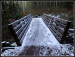 Icy Bridge |
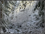
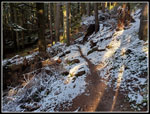 Snow Begins On Trail |
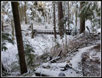 Nearing Big Bridge |
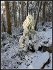
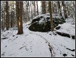 Big Green Erratic |
 Lit Up Tree |
 Quick Link View |
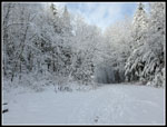 On Main Road |
 Lower Viewpoint |
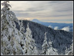
 South Tiger Mountain |
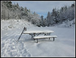 Snow On Table |
 Snowy Power Link Trail |
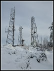 Summit Towers |
 Rainier From Summit |
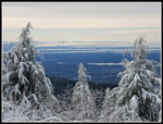 Fog In Valleys |
 More Snow On Summit |
 Heading Down |
 On OTG Trail |
 A Few Tire Tracks |
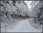 Descending Road |
 3.1 Miles To Go |
 Another Bridge |
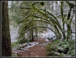 Green Arbor |
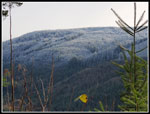 West Rattlesnake Mt. |
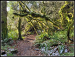 Best Arbor |
Trips - 2021
Home