10-30-21
Gary
and John were free for a hike.
It rained all last week and is forecast to rain most of next week. The
weekend promised two sunny days. We chose Saturday. I had been up to
Frog Mountain four weeks earlier. It was a cloudy day and the views
were not as good as hoped. I wanted to go back and Gary and John had
not yet done the hike. The night before the conditions looked to be
cold in the morning but otherwise excellent. In the morning Gary
emailed and texted me to say that the forecast now called for wind
gusts up to 29 mph. Along with near freezing morning temperatures that
would not be a lot of fun. We fell back on another idea we had
considered. The wind on the east side of the Cascades did not look to
be very strong. At the last minute, we changed to a trip back to
Exclamation Point Rock and the western larch seen on the way. We
changed the meeting place to Eastgate from Bothell and met there just
before 7:00 am. We headed east to Cle Elum then north on Highway 970 to
the Teanaway Road. Up to the West Fork road to the end of pavement and
then on to the gate. We arrived at about 9:00 am. We were packed u and
on our way at 9:09 am. The sky was blue and it was 23 degrees. That was
7 degrees colder than forecast.
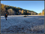
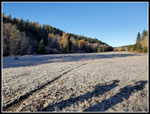
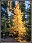
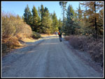
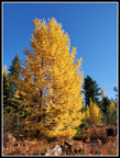
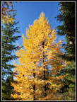
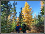
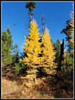
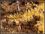
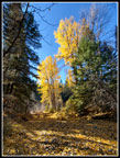
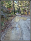
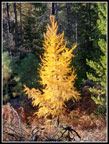
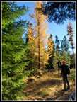
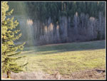
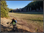
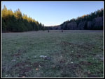
We headed out into the big meadow. The ground was frozen solid. The grass was brown with white frost. The big leaf trees along the WF Teanaway River were nearly leafless. We were too late for that fall color. We quickly were out in the open meadow and in the sunshine. The wind was very light, thankfully. My glove went off and on with each photo. After a long hot summer, 23 degrees felt very cold. On our recent backpacking trip, Gary and I had 17 degrees in the morning. This day felt just as cold. The meadow lasted .80 miles. An old spur road was our ticket up the steep slope. On an early spring trip here Gary and I ran into snow in the forest above the meadow. In late spring Janet and I found wildflowers. This day we had neither. The route winds around before reaching the main road. We knew that just before reaching the road there are a number of western larch trees. Some were a bit past prime but there was still a lot of golden colors.
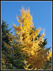
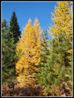
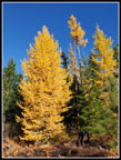
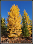
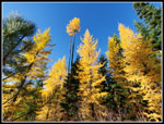
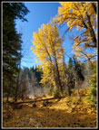
We headed off the trail and worked our way among the larch trees. They were dull at some angles to the sun and quite bright at others. The sun was still pretty low in the sky. We soon popped out on the road and turned right. This was going away from our Exclamation Point Rock but there is another very nice bunch of larch trees on the other side of the road a short way along. These were more in the open and much closer to the peak. We spent a considerable amount of time just winding through the larch trees. Some very nice colors and the sun was a bit higher adding to the brightness. The bright blue sky really set off the golden larch. There was nowhere close to the number of larch we saw at Carne Basin several weeks earlier. What was here was really nice, however. We stayed in the larch forest rather and aimed for the road farther along. We came out a bit farther up the road than where we first reached it. The route soon drops to cross a bridge. After that we climbed up to a higher spot before the descent down to the WF Teanaway River.
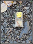
At the bottom of the hill, Gary spotted the two big cottonwood trees between the road and the river. Kim and I saw them several years ago when they were at peak fall color. This day they were a bit past peak but with plenty of color still on the trees. The ground was also covered with fallen golden leaves. It was very photogenic. We soon reached the bridge over the river. Just before that John pointed out a mousetrap in the road. Huh? Why would there be a mousetrap on a seldom used road. It still worked. On the way back we saw one farther down the road. Another one or the same one moved? We did not know.
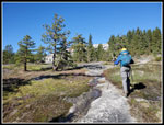
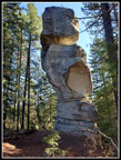
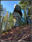
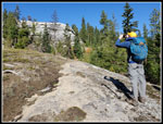
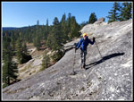
We headed along the road wondering how big "Teanaway Lake" would be. There is a puddle that can be small after a long dry summer or huge after fall or spring rains. We have had a lot of rain the past few weeks. It was huge. Several puddles close together must have been 80' long. We just squeezed by the side without having to slog through the brush. The last climb soon began. Up we went. We started seeing some larch trees off to the side of the road. One was right alongside. We were now a bit more than 4 miles from the trailhead. After passing a couple of old logging spurs we headed off the road and up the slickrock. Big pine trees and slabs or rock surrounded by grass and moss. The side of Mammoth Rock was soon in sight. One final steep push up to the ridge top and there was Exclamation Point Rock.
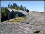
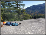
I have quite a few photos of the rock from all angles and on sunny and cloudy days. With a little snow at the base to none at all. We had a shorter than usual stay just adding a few more photos to my archive. As we neared the ridge top we could hear the wind in the treetops. The route to Mammoth Rock is behind the big vertical wall of the rock. No wind along here. At the other end, we climbed up onto the far end of the rock and there was enough wind to be quite chilly. We took a chance that it would be a little less at the far end where a few trees provide a little windbreak. In fact, that was the case. Still some breeze but not too bad. Several more layers did go on to keep us warm enough. We arrived at our lunch spot at 12:11 pm. With all our breaks and photos we took 3:02 to hike 5.1 miles.
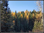
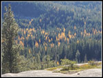
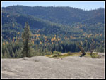
Across the valley, we could see many golden larch trees mixed in with more evergreen trees. It is a sizable larch forest. Though still quite cool the sunshine really helped. We stayed until 12:45 pm. It is now dark by 6:15 pm so we headed back a little earlier than I would have liked. Crossing Mammoth Rock we met a solo hiker. The only person on foot we were to see all day. Not bad solitude for a larch hike. Rather than retrace our steps, we decided to head down the far side of Mammoth Rock. Gary and I did this a few years ago and heard rushing water. We headed off trail and found a dozen foot tall waterfall. Water popped out of the ground at the top and ran back into the ground just after the falls. The only water seen was over the falls. It had a good flow that day. We came back with John and there was not a drop of water. After all the recent rain, we hoped for a waterfall this day. We did not hear the water but poked around and found the falls. Just a few drops falling now. I'm sure John thinks we just made up this so called waterfall.
Rather than drop to the road we climbed back uphill as we headed back. This brought up back to the spot just before the steep climb to Exclamation Point Rock. We headed back uphill to the Rock. Our plan now was to follow the ridge downhill. We have done this several times. The path goes down then up and down along the sandstone ridge. Some neat rock formations along here. We also had views north to Teanaway Peaks around Miller, Iron Bear, and even the top of now snowy Dragontail Peak in the Stuart Range. We continued on to the end of the ridge. It drops vertically left and straight ahead. It drops steeply to the right but with a ledge that allows descent. From the top, I saw a motorcycle and the others saw two of them. That plus the hiker up on Mammoth Rock were the only people seen all day. Only one passed by us.
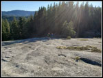
We had followed the trail left down to Sandstone Creek on earlier trips. This time we headed for the road we had walked up in the morning. The narrow path turned into an old road and we were soon back on our ascent route. We hiked down to the bridge over the WF Teanaway then uphill then down to the smaller bridge crossing. Farther on we headed uphill towards the second big slickrock slab of the day. By now my slight plantar foot pain was getting much worse. Hiking on a road is a lot harder on that foot than on a dirt trail. I was limping as we reached our high point just above the slickrock. It was still sunny. Nice views across the valley to more golden larch trees. We had one last break sitting in the sunshine. All too soon, we started down. I was slower but kept moving
We reached the road and shortly found our trail heading into the forest. A few more stops for larch photos though the lighting was not as good in the late afternoon. Once down to the meadow it was just another .80 miles to go. My foot was very pleased to see the car. We arrived back at the car at 4:45 pm. It was almost a nine to five day. Just under 8 hours on the route. It was a bit chilly in the morning but the weather turned out great. We had a little cold breeze at times but it was not a problem. It was a treat to have a second larch trip this year. John just managed to get in one larch trip before the needles will be falling soon. Even the drive home was fine for a change. I had been in at least some stop and go traffic on every trip east on I-90 since spring. All in all, it was a very nice day for a hike. Especially for one that required a change of plans right before we left home.
Click on thumbnails to get
larger pictures.
Trips - 2021
Home
We headed out into the big meadow. The ground was frozen solid. The grass was brown with white frost. The big leaf trees along the WF Teanaway River were nearly leafless. We were too late for that fall color. We quickly were out in the open meadow and in the sunshine. The wind was very light, thankfully. My glove went off and on with each photo. After a long hot summer, 23 degrees felt very cold. On our recent backpacking trip, Gary and I had 17 degrees in the morning. This day felt just as cold. The meadow lasted .80 miles. An old spur road was our ticket up the steep slope. On an early spring trip here Gary and I ran into snow in the forest above the meadow. In late spring Janet and I found wildflowers. This day we had neither. The route winds around before reaching the main road. We knew that just before reaching the road there are a number of western larch trees. Some were a bit past prime but there was still a lot of golden colors.
We headed off the trail and worked our way among the larch trees. They were dull at some angles to the sun and quite bright at others. The sun was still pretty low in the sky. We soon popped out on the road and turned right. This was going away from our Exclamation Point Rock but there is another very nice bunch of larch trees on the other side of the road a short way along. These were more in the open and much closer to the peak. We spent a considerable amount of time just winding through the larch trees. Some very nice colors and the sun was a bit higher adding to the brightness. The bright blue sky really set off the golden larch. There was nowhere close to the number of larch we saw at Carne Basin several weeks earlier. What was here was really nice, however. We stayed in the larch forest rather and aimed for the road farther along. We came out a bit farther up the road than where we first reached it. The route soon drops to cross a bridge. After that we climbed up to a higher spot before the descent down to the WF Teanaway River.
At the bottom of the hill, Gary spotted the two big cottonwood trees between the road and the river. Kim and I saw them several years ago when they were at peak fall color. This day they were a bit past peak but with plenty of color still on the trees. The ground was also covered with fallen golden leaves. It was very photogenic. We soon reached the bridge over the river. Just before that John pointed out a mousetrap in the road. Huh? Why would there be a mousetrap on a seldom used road. It still worked. On the way back we saw one farther down the road. Another one or the same one moved? We did not know.
We headed along the road wondering how big "Teanaway Lake" would be. There is a puddle that can be small after a long dry summer or huge after fall or spring rains. We have had a lot of rain the past few weeks. It was huge. Several puddles close together must have been 80' long. We just squeezed by the side without having to slog through the brush. The last climb soon began. Up we went. We started seeing some larch trees off to the side of the road. One was right alongside. We were now a bit more than 4 miles from the trailhead. After passing a couple of old logging spurs we headed off the road and up the slickrock. Big pine trees and slabs or rock surrounded by grass and moss. The side of Mammoth Rock was soon in sight. One final steep push up to the ridge top and there was Exclamation Point Rock.
I have quite a few photos of the rock from all angles and on sunny and cloudy days. With a little snow at the base to none at all. We had a shorter than usual stay just adding a few more photos to my archive. As we neared the ridge top we could hear the wind in the treetops. The route to Mammoth Rock is behind the big vertical wall of the rock. No wind along here. At the other end, we climbed up onto the far end of the rock and there was enough wind to be quite chilly. We took a chance that it would be a little less at the far end where a few trees provide a little windbreak. In fact, that was the case. Still some breeze but not too bad. Several more layers did go on to keep us warm enough. We arrived at our lunch spot at 12:11 pm. With all our breaks and photos we took 3:02 to hike 5.1 miles.
Across the valley, we could see many golden larch trees mixed in with more evergreen trees. It is a sizable larch forest. Though still quite cool the sunshine really helped. We stayed until 12:45 pm. It is now dark by 6:15 pm so we headed back a little earlier than I would have liked. Crossing Mammoth Rock we met a solo hiker. The only person on foot we were to see all day. Not bad solitude for a larch hike. Rather than retrace our steps, we decided to head down the far side of Mammoth Rock. Gary and I did this a few years ago and heard rushing water. We headed off trail and found a dozen foot tall waterfall. Water popped out of the ground at the top and ran back into the ground just after the falls. The only water seen was over the falls. It had a good flow that day. We came back with John and there was not a drop of water. After all the recent rain, we hoped for a waterfall this day. We did not hear the water but poked around and found the falls. Just a few drops falling now. I'm sure John thinks we just made up this so called waterfall.
Rather than drop to the road we climbed back uphill as we headed back. This brought up back to the spot just before the steep climb to Exclamation Point Rock. We headed back uphill to the Rock. Our plan now was to follow the ridge downhill. We have done this several times. The path goes down then up and down along the sandstone ridge. Some neat rock formations along here. We also had views north to Teanaway Peaks around Miller, Iron Bear, and even the top of now snowy Dragontail Peak in the Stuart Range. We continued on to the end of the ridge. It drops vertically left and straight ahead. It drops steeply to the right but with a ledge that allows descent. From the top, I saw a motorcycle and the others saw two of them. That plus the hiker up on Mammoth Rock were the only people seen all day. Only one passed by us.
We had followed the trail left down to Sandstone Creek on earlier trips. This time we headed for the road we had walked up in the morning. The narrow path turned into an old road and we were soon back on our ascent route. We hiked down to the bridge over the WF Teanaway then uphill then down to the smaller bridge crossing. Farther on we headed uphill towards the second big slickrock slab of the day. By now my slight plantar foot pain was getting much worse. Hiking on a road is a lot harder on that foot than on a dirt trail. I was limping as we reached our high point just above the slickrock. It was still sunny. Nice views across the valley to more golden larch trees. We had one last break sitting in the sunshine. All too soon, we started down. I was slower but kept moving
We reached the road and shortly found our trail heading into the forest. A few more stops for larch photos though the lighting was not as good in the late afternoon. Once down to the meadow it was just another .80 miles to go. My foot was very pleased to see the car. We arrived back at the car at 4:45 pm. It was almost a nine to five day. Just under 8 hours on the route. It was a bit chilly in the morning but the weather turned out great. We had a little cold breeze at times but it was not a problem. It was a treat to have a second larch trip this year. John just managed to get in one larch trip before the needles will be falling soon. Even the drive home was fine for a change. I had been in at least some stop and go traffic on every trip east on I-90 since spring. All in all, it was a very nice day for a hike. Especially for one that required a change of plans right before we left home.
 Cold shaded meadow |
 Sunny Meadow Is Warmer |
 Icy Leaves |
 First Larch Tree |
 Shady Road |
 Tall Larch |
 Nice Colors |
 Larch & Pine |
 Direct Sunshine |
 Changing Light |
 Looking Up |
 Two Larch |
 Guys At Work |
 Twins |
 Needles Close Up |
 More Icy Leaves |
 Golden Cottonwoods |
 Leaves On Ground Too |
 Mixed Forest |
 Mouse Trap On Road |
 Teanaway Lake |
 Lit Up Fireweed |
 On Fire |
 On The Slickrock |
 Exclamation Point Rock |
 Another View |
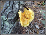 Big Mushroom |
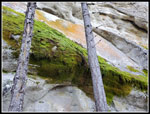 Moss & Lichen |
 John On Mammoth Rock |
 Larchy Forest |
 View From Rock |
 Gary Enjoys The Sun |
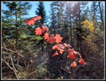 Red Leaves |
 Back On Slickrock |
 Hiking Ridge |
 Descending |
 More Larch |
 Leafless Trees & Meadow |
 Dropping To Meadow |
 Meadow In Shade |
Trips - 2021
Home