7-31-21
After
a long sunny July things
changed on the last day of the month. Gary was free for a hike. The day
would be overcast but still in the 80s. Smoke was finally getting near
Western Washington. We chose an early start and a short drive. I have
been up Mt. Washington twice via the Change Creek Trail. Gary had not
been up it yet. We figured up the new and down the usual Mt. Washington
Trail. The low temp was forecast to be about 67 degrees at about 7:00
am
before it started going up again. We met at Eastgate at 6:05 am and
headed east. There were two cars and one converted small bus in the
lot. A person was still in one car. Only two vehicles worth of folks on
the trail. We were on our way at 6:38 am.
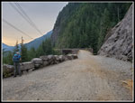
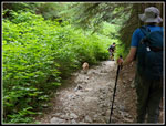
We hiked up to the old Iron Horse railroad grade and turned left. At about 1.2 miles from the start we turned off on the Change Creek Trail. On my two previous trips here I did not see anyone on this trail. This time we hiked at least three minutes before seeing a group ahead of us. What were the odds? They stopped shortly and we went by. Did not see them again. The trail is steep and narrow but in pretty good shape. It did not take long going uphill to realize just how high the humidity was. I was soaked in minutes. It made it difficult to go very fast. Combined width zero breeze and the water just stayed on my. Almost no cooling evaporation. Thankfully this is a very rare occurrence in Washington state. The rarity probably makes it that much harder to deal with.
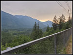
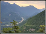
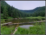
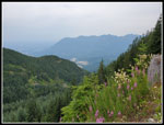
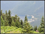
Well up the switchbacks a group of runners passed us by. They wee not running this part. Less than half our ages and moving pretty fast. The second group I had ever seen on this route. Just a few minutes after the first. At the Olallie Point turnoff we went a little way but decided not to scramble the last bit. Back on trail it was now much less steep. Still humid but easier walking. At the turnoff for Hall Point we turned left and hiked on up. The clouds were high and we could see all the peaks around us. Time for a food and water break too. Back down to the trail and on we went. The old road along here really looks like trail now. It was still early but getting warmer. At the pond junction we turned left and went to the pond. It was 8:45 am. Just over two hours to hike 3.2 miles. Ridiculously slow but with the heat and humidity plus several breaks and photos it was understandable. The very early start helped. It was still pretty early. I hiked around the pond on my first visit. The road went well past the pond and came back on the other side of the valley. The second time John and I did not go there. The pond was better looking than I expected.
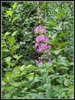
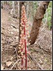
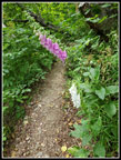
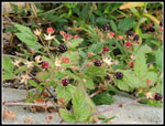
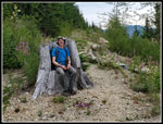
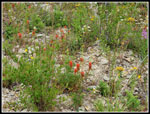
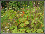
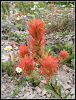
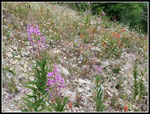
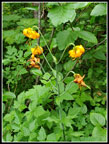
Our route climbed back up to the road again. Along the way Gary noticed two saprophytes. John and I saw a couple two. Looking at the photos from both trips showed they were in the same place. The only ones seen all day. Where the trail returned to the road was one of the best parts of the day. The road was more open with some views out. It travels down the valley away from Mt. Washington. This route is not all that direct. Wildflowers started very quickly. some lupine then some Indian paintbrush, then more. Lots of daisies too. Gary noticed the native blackberries. Lots of ripe ones. We slowed down a whole lot along here. Small berries but very sweet. In places the old road had big rock blocks providing a border. Not sure when this was done. There are several seats too made from big stumps. We discussed why the big stumps were in the middle of an old logging road. Put in place at a much later date?
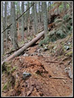
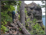
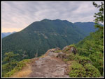
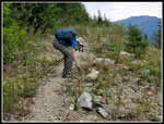
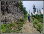
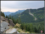
We did the first 1.2 miles at 2.9 mph. A short climb then the railroad grade. After that the humidity and multiple stops kept the pace very slow. We had all day but were taking more time than usual. At the next junction we were turned onto the old Mt. Washington road/trail. From here to the summit was a route we hiked for decades before the newer trail was built. The road used to be open along a cliff. now it has trees and bushes forming a thick border. It feels much different. We hiked around Change Peak then dropped down to The Great Wall. The Great Wall used to be bare road atop a ridge plowed flat. Now it is a route in a forest atop a narrow ridge plowed flat. On the other side we reached the ridge forming the top edge of the Seattle watershed. The road was in shade and cooler than anywhere else coming up. At the next junction the old trail goes between the roads and straight up the ridge line. It is very steep at the bottom. We slogged up the last few hundred feet to the open slope just below the top. There were two groups there. One of them warmed us of the thick bugs on the summit. We headed up to tag the top. It was 10:44 am. We had hiked 6.3 miles and almost all of our 3300' of elevation gain.
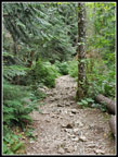
We went back to the open spot and there were bugs there too. No Mt. Rainier view with clouds and haze. We could see down to Chester Morse Lake. We decided to drop down to the point on the north ridge for our lunch. Several more groups were coming up as we descended. At the north ridge it was a bit more over grown than we recalled. Not a lot of views or places to step off the trail. We managed to find a spot. Hot humid and a little buggy. Perfect spot for lunch. Sort of. Soon enough we headed on down. I hike this trail about 3 out of every 4 years. The downhill is just a long loose rock route. Bad when it is dry and worse when wet. And yet we keep on hiking it. Now we had those four miles of rock. We just slogged on down. We were passed a number of times but younger folks zooming on down. On the positive side, it is mostly in shade. Still humid but not in sunshine. Not that there was much sunshine. The overcast lasted all day. It was warmer in the open but not sunny.
To add to the fun Gary tweeked his ankle slipping on loose rock. We slowed down but he made it out just fine. He felt better soon after so this does not seem like a lasting injury. Just another fun part of the day. We made it back to the trailhead at 1:43 pm. It was a pretty long day but with the early start we were down early. The lot was mostly full but there were open spots. We had no problem getting back to town with minimal traffic.
This was an interesting day. The heat and humidity was awful. It would have been in most places. We had a short drive and an early start. Two groups on the Change Creek trail was two more than expected but only two over 6+ miles. The wildflowers were pretty good in that one spot. I saw saprophytes for about the fifth or sixth straight week. The berries were tasty. The rocky descent was as bad as always. Bugs on top but few anywhere else. We did get in 10.4 miles with 3300' of elevation gain under trying conditions. All in all, not so bad. Gary hiked a new trail and we had a fun summer day without the wildfire smoke drifting in.
Click on thumbnails to get
larger pictures.
Trips - 2021
Home
We hiked up to the old Iron Horse railroad grade and turned left. At about 1.2 miles from the start we turned off on the Change Creek Trail. On my two previous trips here I did not see anyone on this trail. This time we hiked at least three minutes before seeing a group ahead of us. What were the odds? They stopped shortly and we went by. Did not see them again. The trail is steep and narrow but in pretty good shape. It did not take long going uphill to realize just how high the humidity was. I was soaked in minutes. It made it difficult to go very fast. Combined width zero breeze and the water just stayed on my. Almost no cooling evaporation. Thankfully this is a very rare occurrence in Washington state. The rarity probably makes it that much harder to deal with.
Well up the switchbacks a group of runners passed us by. They wee not running this part. Less than half our ages and moving pretty fast. The second group I had ever seen on this route. Just a few minutes after the first. At the Olallie Point turnoff we went a little way but decided not to scramble the last bit. Back on trail it was now much less steep. Still humid but easier walking. At the turnoff for Hall Point we turned left and hiked on up. The clouds were high and we could see all the peaks around us. Time for a food and water break too. Back down to the trail and on we went. The old road along here really looks like trail now. It was still early but getting warmer. At the pond junction we turned left and went to the pond. It was 8:45 am. Just over two hours to hike 3.2 miles. Ridiculously slow but with the heat and humidity plus several breaks and photos it was understandable. The very early start helped. It was still pretty early. I hiked around the pond on my first visit. The road went well past the pond and came back on the other side of the valley. The second time John and I did not go there. The pond was better looking than I expected.
Our route climbed back up to the road again. Along the way Gary noticed two saprophytes. John and I saw a couple two. Looking at the photos from both trips showed they were in the same place. The only ones seen all day. Where the trail returned to the road was one of the best parts of the day. The road was more open with some views out. It travels down the valley away from Mt. Washington. This route is not all that direct. Wildflowers started very quickly. some lupine then some Indian paintbrush, then more. Lots of daisies too. Gary noticed the native blackberries. Lots of ripe ones. We slowed down a whole lot along here. Small berries but very sweet. In places the old road had big rock blocks providing a border. Not sure when this was done. There are several seats too made from big stumps. We discussed why the big stumps were in the middle of an old logging road. Put in place at a much later date?
We did the first 1.2 miles at 2.9 mph. A short climb then the railroad grade. After that the humidity and multiple stops kept the pace very slow. We had all day but were taking more time than usual. At the next junction we were turned onto the old Mt. Washington road/trail. From here to the summit was a route we hiked for decades before the newer trail was built. The road used to be open along a cliff. now it has trees and bushes forming a thick border. It feels much different. We hiked around Change Peak then dropped down to The Great Wall. The Great Wall used to be bare road atop a ridge plowed flat. Now it is a route in a forest atop a narrow ridge plowed flat. On the other side we reached the ridge forming the top edge of the Seattle watershed. The road was in shade and cooler than anywhere else coming up. At the next junction the old trail goes between the roads and straight up the ridge line. It is very steep at the bottom. We slogged up the last few hundred feet to the open slope just below the top. There were two groups there. One of them warmed us of the thick bugs on the summit. We headed up to tag the top. It was 10:44 am. We had hiked 6.3 miles and almost all of our 3300' of elevation gain.
We went back to the open spot and there were bugs there too. No Mt. Rainier view with clouds and haze. We could see down to Chester Morse Lake. We decided to drop down to the point on the north ridge for our lunch. Several more groups were coming up as we descended. At the north ridge it was a bit more over grown than we recalled. Not a lot of views or places to step off the trail. We managed to find a spot. Hot humid and a little buggy. Perfect spot for lunch. Sort of. Soon enough we headed on down. I hike this trail about 3 out of every 4 years. The downhill is just a long loose rock route. Bad when it is dry and worse when wet. And yet we keep on hiking it. Now we had those four miles of rock. We just slogged on down. We were passed a number of times but younger folks zooming on down. On the positive side, it is mostly in shade. Still humid but not in sunshine. Not that there was much sunshine. The overcast lasted all day. It was warmer in the open but not sunny.
To add to the fun Gary tweeked his ankle slipping on loose rock. We slowed down but he made it out just fine. He felt better soon after so this does not seem like a lasting injury. Just another fun part of the day. We made it back to the trailhead at 1:43 pm. It was a pretty long day but with the early start we were down early. The lot was mostly full but there were open spots. We had no problem getting back to town with minimal traffic.
This was an interesting day. The heat and humidity was awful. It would have been in most places. We had a short drive and an early start. Two groups on the Change Creek trail was two more than expected but only two over 6+ miles. The wildflowers were pretty good in that one spot. I saw saprophytes for about the fifth or sixth straight week. The berries were tasty. The rocky descent was as bad as always. Bugs on top but few anywhere else. We did get in 10.4 miles with 3300' of elevation gain under trying conditions. All in all, not so bad. Gary hiked a new trail and we had a fun summer day without the wildfire smoke drifting in.
 Change Creek Bridge |
 Hazy View |
 Log Over Trail |
 Trail & Pinnacle |
 SF Snoqualmie Valley |
 Hall Point |
 Fireweed |
 Pond |
 Pinddrop |
 Foxglove |
 Native Blackberries |
 Gary's Throne |
 Wildflowers |
 Berry Eating Time |
 Thimbleberry Paintbrush |
 Close Up |
 More Flowers |
 Vertical Wall |
 Fire Training Center |
 McClellan Butte |
 Great Wall View North |
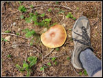 Big Mushroom |
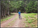 Gary On Road |
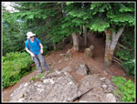 Gary On Summit |
 Hazy Lake |
 Tiger Lilies |
 Brushy Rocky Trail |
 Very Rocky Trail |
Trips - 2021
Home