6-20-21
Kim
joined me for an easy hike on a
hot day. I hiked Wednesday evening then worked re-roofing a friends
house on Thursday, Friday, and Saturday. By Sunday I wanted to hike but
was not up for much elevation gain. Adding to that was the forecast for
near 80 degrees. We wanted to find a place close that would be cooler
and not crowded. We settled on the Middle Fork Snoqualmie River Valley
and the new Oxbow Lake Trail combined with the very nearby CCC Trail.
One trail new and the other a road turned trail built nearly 90 years
ago. We headed out fairly early to beat the heat and get a parking
spot. It was Fathers Day and while the lots at Mailbox Peak were full
there were only a few cars parked along the road at 7:45 am. The Oxbow
lots had a number of cars but a number of empty spaces too. We arrived
just before 8:00 am and were on our way a few minutes later. We parked
at the second lot by the bathrooms.
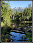
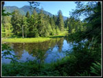
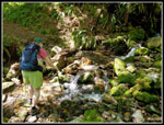
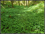
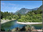
Kim had already done the Oxbow Lake Loop one time before in the fall. We took the short trail to the other lot. Along the way we stopped at the viewpoint looking down on the Middle Fork River. The low morning sun had the water sparkling. When we reached the other lot we decided to hike the loop clockwise. It drops down to a short spur over tot he river. One couple was there and was laving. Two fishermen were wading in the river. A neat spot. The Trail to the loop start and the loop itself are 2.0 miles long with minimal elevation change. Back on our way be crossed a good sized bridge with a good look over at the oxbow. A meander of the river was left cut off from the river after a course change. We hiked around a good part of it. The cool forest and views to the oxbow lake made for a short but fun hike. Very good for folks who can't do longer steeper hikes.
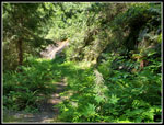
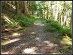
After that we walked the road a short few minutes to the Bessemer Road which accesses the CCC Road Trail. Much of the almost one mile road walk was in the shade as the morning sun was still pretty low. Across the big truck bridge we went. Flat grade turned to a bit of a climb until we reached the CCC Road Trail. To the right it is a road for a short way. I have been up South Bessemer a number of times including four weeks earlier. On previous trips I turned left a short way to see Big Blowout Creek. There was no bridge across the creek until my 2019 visit. It was still there in 2021. Ironically I was on the other side of the creek back in about 1979. I drove my 1971 Ford Pinto up the Mt. Si Road and on to the CCC Road. It was in such good shape my very minimal ground clearance did not stop me from reaching Big Blowout Creek. Even then there was no bridge and I had to turn around. Now I would be walking it some 42 years later.
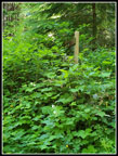
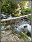
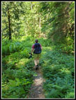
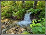
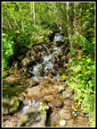
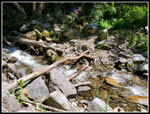
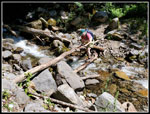
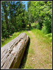
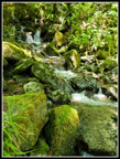
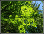
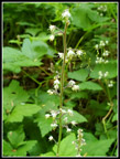
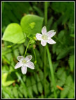
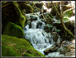
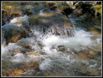
The log over the creek has no handrail and is not especially wide. The surface has been flattened and cross hatches cut into it. The creek was too high to rock hop so we took the log bridge. We did fine in both directions. The CCC Trail has minimal elevation change. Easy walking. We hiked it about 2.7 miles before turning around. Most of the route is in forest. It was much cooler than out in the sunshine. We saw a few wildflowers but not many. There are a number of creeks to cross. Two are a bit challenging to get across with dry feet. Most are easy rock hops. At the next big one we stopped for a break. A two generation family passed us by and we wished the two men a happy Fathers Day. Another couple passed us a bit later. The cascading creek, rocks to sit on , and shade made this a great stopping place. Best of all, we had minimal bug problems. Hardly noticed them.
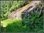
We paced up and continued on. I crossed the creek on a low log with a higher one to hold onto. It did not move at all. Kim followed and near the end of the log it did move and she fell into the water. Her wet boots were not a problem for her. At the next creek crossing half of the couple who passed us early had had enough. The first log crossing, the second log crossing where we took a break. and now a short seep drop to the creek and more rock hopping. This one was actually not bad. The slope above the road turned to a rock wall. The road was blasted out of solid rock along here. Part way up in one place we saw Scotch broom in bloom. It gets everywhere. More creeks needed crossing but none were more than an easy rock hop.
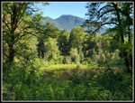
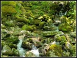
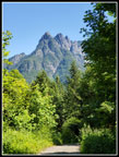
At 11:50 a we reached our turnaround point at Brawling Creek. We were now right below the summit of Green Mountain. The creek had a series of small cascades. Big mossy rocks were all around it. It was fairly wide but not deep. Another easy rock hop. This spot was even better than our first break spot. Time for the rest of our lunches. Nobody came through during our stay. Total solitude. It was much cooler than in sunshine. A cool breeze coming down the creek and almost total shade. We were in no hurry to leave. We stayed until almost 1:00 pm. The hike back was slow on purpose. I nice cool hike on a hot day. A few mountain bikes did pass us during the hike. We did not see many folks on the way back. In placers the forest broke for a minute and provided views out to the valley below and the peaks around us. Russian Butte and Mailbox Peak were seen several times.
No breaks on the way back. We arrived at the log bridge and the Bessemer Road at 2:52 pm. The sun was far enough along to not be shining directly down on our road walk most of the way. It was very pleasant. Back at the Middle Fork Road we had that short walk with no siding along the road but it was fine. Only one or two cars passed us. On the short Oxbow trail back to the east parking spot we stopped again at the river overlook. In the morning the low sun sparkled on the water and the peaks were dark and a bit hazy. In the afternoon the lighting was much different. Below us several birds were snatching bugs out of the air. There were a lot of bird calls all day long. We spent another half hour here. Still pretty cool in the forest with some breeze and beautiful views of the valley, river, and peaks. A helicopter flew by low near the river at one point. It had no markings like I would expect from Search and Rescue so I hope it was just some sightseeing.
On the drive home the road was still not lined with cars near Mailbox Peak. Still lots of cars but few if any illegally parked on the roadway. I chalk that up to it being Fathers Day and few folks out hiking. This was a fun day. Two new trail sections I had not hiked though 42 years ago I drove my car on one of them. The day was much cooler than being in the city. We did not get much elevation gain with only about 800' but we did hike 10 miles. This makes for a good route for a hot day or for a low elevation winter walk. Our highest point was just under 1600'. A fun day on a close to the city hike with few other people.
Click on thumbnails to get
larger pictures.
Trips - 2021
Home
Kim had already done the Oxbow Lake Loop one time before in the fall. We took the short trail to the other lot. Along the way we stopped at the viewpoint looking down on the Middle Fork River. The low morning sun had the water sparkling. When we reached the other lot we decided to hike the loop clockwise. It drops down to a short spur over tot he river. One couple was there and was laving. Two fishermen were wading in the river. A neat spot. The Trail to the loop start and the loop itself are 2.0 miles long with minimal elevation change. Back on our way be crossed a good sized bridge with a good look over at the oxbow. A meander of the river was left cut off from the river after a course change. We hiked around a good part of it. The cool forest and views to the oxbow lake made for a short but fun hike. Very good for folks who can't do longer steeper hikes.
After that we walked the road a short few minutes to the Bessemer Road which accesses the CCC Road Trail. Much of the almost one mile road walk was in the shade as the morning sun was still pretty low. Across the big truck bridge we went. Flat grade turned to a bit of a climb until we reached the CCC Road Trail. To the right it is a road for a short way. I have been up South Bessemer a number of times including four weeks earlier. On previous trips I turned left a short way to see Big Blowout Creek. There was no bridge across the creek until my 2019 visit. It was still there in 2021. Ironically I was on the other side of the creek back in about 1979. I drove my 1971 Ford Pinto up the Mt. Si Road and on to the CCC Road. It was in such good shape my very minimal ground clearance did not stop me from reaching Big Blowout Creek. Even then there was no bridge and I had to turn around. Now I would be walking it some 42 years later.
The log over the creek has no handrail and is not especially wide. The surface has been flattened and cross hatches cut into it. The creek was too high to rock hop so we took the log bridge. We did fine in both directions. The CCC Trail has minimal elevation change. Easy walking. We hiked it about 2.7 miles before turning around. Most of the route is in forest. It was much cooler than out in the sunshine. We saw a few wildflowers but not many. There are a number of creeks to cross. Two are a bit challenging to get across with dry feet. Most are easy rock hops. At the next big one we stopped for a break. A two generation family passed us by and we wished the two men a happy Fathers Day. Another couple passed us a bit later. The cascading creek, rocks to sit on , and shade made this a great stopping place. Best of all, we had minimal bug problems. Hardly noticed them.
We paced up and continued on. I crossed the creek on a low log with a higher one to hold onto. It did not move at all. Kim followed and near the end of the log it did move and she fell into the water. Her wet boots were not a problem for her. At the next creek crossing half of the couple who passed us early had had enough. The first log crossing, the second log crossing where we took a break. and now a short seep drop to the creek and more rock hopping. This one was actually not bad. The slope above the road turned to a rock wall. The road was blasted out of solid rock along here. Part way up in one place we saw Scotch broom in bloom. It gets everywhere. More creeks needed crossing but none were more than an easy rock hop.
At 11:50 a we reached our turnaround point at Brawling Creek. We were now right below the summit of Green Mountain. The creek had a series of small cascades. Big mossy rocks were all around it. It was fairly wide but not deep. Another easy rock hop. This spot was even better than our first break spot. Time for the rest of our lunches. Nobody came through during our stay. Total solitude. It was much cooler than in sunshine. A cool breeze coming down the creek and almost total shade. We were in no hurry to leave. We stayed until almost 1:00 pm. The hike back was slow on purpose. I nice cool hike on a hot day. A few mountain bikes did pass us during the hike. We did not see many folks on the way back. In placers the forest broke for a minute and provided views out to the valley below and the peaks around us. Russian Butte and Mailbox Peak were seen several times.
No breaks on the way back. We arrived at the log bridge and the Bessemer Road at 2:52 pm. The sun was far enough along to not be shining directly down on our road walk most of the way. It was very pleasant. Back at the Middle Fork Road we had that short walk with no siding along the road but it was fine. Only one or two cars passed us. On the short Oxbow trail back to the east parking spot we stopped again at the river overlook. In the morning the low sun sparkled on the water and the peaks were dark and a bit hazy. In the afternoon the lighting was much different. Below us several birds were snatching bugs out of the air. There were a lot of bird calls all day long. We spent another half hour here. Still pretty cool in the forest with some breeze and beautiful views of the valley, river, and peaks. A helicopter flew by low near the river at one point. It had no markings like I would expect from Search and Rescue so I hope it was just some sightseeing.
On the drive home the road was still not lined with cars near Mailbox Peak. Still lots of cars but few if any illegally parked on the roadway. I chalk that up to it being Fathers Day and few folks out hiking. This was a fun day. Two new trail sections I had not hiked though 42 years ago I drove my car on one of them. The day was much cooler than being in the city. We did not get much elevation gain with only about 800' but we did hike 10 miles. This makes for a good route for a hot day or for a low elevation winter walk. Our highest point was just under 1600'. A fun day on a close to the city hike with few other people.
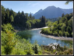 MF Snoqualmie River |
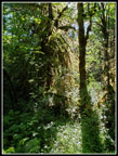 Mossy Trees |
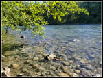 At The River |
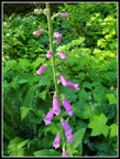 Foxglove |
 Oxbow Lake |
 Peaks & Colors |
 Mushrooms On Tree |
 More Mushrooms |
 Reflection |
 Brush Covers Sign |
 Kim Crosses Creek |
 Narrow Trail |
 Left Turn |
 Break At Creek |
 Across Creek |
 Kim Crossing |
 Next Creek |
 Rock Wall Ahead |
 Rock Wall |
 Mountain Views |
 Sunshine |
 Brawling Creek |
 Lit Up Leaves |
 Mossy Creek |
 Foam Flower |
 False Lily Of The Valley |
 Spring Beauty |
 Goat's Beard |
 Old Wider Road |
 White Water |
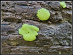 Slime Mold |
 Another Creek |
 Gumby |
 Russian Butte |
 Back At River |
Trips - 2021
Home